
Cabo Verde Google Maps is a site/tool that offers a wide range of map views (topographic, satellite, street view) and navigation options, with little effort on your part, yet efficiently. If you need to plan a trip to a new place like Cabo Verde, Google maps are available on desktop, mobile, or tablet. This Google maps and information page is dedicated to Cabo Verde, Africa (54 countries), showing its location, country facts, details about its capital city Praia, bordering countries like none, and plenty of other information which may be interesting when you visit this African state.
Quick links: Google Maps Cabo Verde, Praia Google maps, Driving Directions Cabo Verde, Printable Road Map.
About Cabo Verde in a nutshell
- Poor soils and lack of surface water mean that Cape Verde is dependent on food aid.
- Conventional short form of the name: Cabo Verde
- The conventional long form of the name: Republic of Cabo Verde
- Local long form: Republica de Cabo Verde
- Local short form: Cabo Verde
- Former name(s): N/A
- Etymology: the name derives from Cap-Vert (Green Cape) on the Senegalese coast, the westernmost point of Africa and the nearest mainland to the islands.
- The legal system in Cabo Verde: civil law system of Portugal.
- Climate: Warm, and very dry. Subject to droughts that can sometimes last for years at a time.
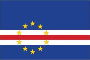
- The national symbols are ten, five-pointed, yellow stars; national colors: blue, white, red, yellow.
- Internet TLD: .cv
Background
The Portuguese discovered and colonized the uninhabited islands in the 15th century. Cabo Verde subsequently became a trading center for enslaved Africans and later an important coaling and resupply stop for whaling and transatlantic shipping. Cabo Verdes Krioulo language, music, and pano textiles are fusing European and various African cultural traditions. Following independence in 1975 and a tentative interest in unification with Guinea-Bissau, a one-party system was established and maintained until multi-party elections were held in 1990.
Cabo Verde continues to sustain one of Africas most stable democratic governments and one of its most stable economies, maintaining a currency formerly pegged to the Portuguese escudo and then the euro since 1998. During the second half of the 20th century, repeated droughts caused significant hardship and prompted heavy emigration. As a result, Cabo Verdes expatriate population – concentrated in Boston and Western Europe – is more significant than its domestic one. Most Cabo Verdeans have both African and Portuguese antecedents. Cabo Verde’s population descends from its first permanent inhabitants in the late 15th-century a preponderance of enslaved West Africans, a small share of Portuguese colonists, and even fewer Italians, Spaniards, and Portuguese Jews. Among the nine inhabited islands, population distribution is variable. Islands in the east are arid and are home to the country’s growing tourism industry. Western islands receive more precipitation and support larger populations, but agriculture and livestock grazing have damaged soil fertility and vegetation. For centuries, the country’s overall population size has fluctuated significantly, as recurring periods of famine and epidemics have caused high death tolls and emigration.
Geography
Ten main islands and eight smaller islets, all of volcanic origin. Mostly mountainous, with steep cliffs and rocky headlands.
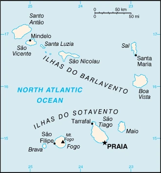
In the Atlantic Ocean, off the west coast of Africa lies the group of islands that make up Cape Verde, a Portuguese colony until it gained independence in 1975.
This state is located in Western Africa, a group of islands in the North Atlantic Ocean, west of Senegal, under the coordinates of 16 00 N, 24 00 W, covering an area of 4,033 sq km with a coastline of 965 km. Cabo Verde is Slightly larger than Rhode Island.
Steep, rugged, rocky, volcanic, with Mt. Fogo (a volcano on Fogo Island) 2,829 m as the highest point of Cabo Verde, while Atlantic Ocean 0 m as the lowest point, causing a mean elevation at N/A throughout the country. With a total of 4,033 sq km, Cabo Verde has 4,033 sq km of land and 0 sq km water surface area.
Strategic location 500 km from the west coast of Africa near major north-south sea routes; important communications station; the vital sea and air refueling site; one of four North Atlantic archipelagos that make up Macaronesia; the others are Azores (Portugal), Canary Islands (Spain), and Madeira (Portugal)
The climate in Cabo Verde is as follows: Temperate, warm, dry summer, precipitation meager and erratic.
When you visit Cabo Verde, the natural hazards shall be considered: Prolonged droughts; seasonal harmattan wind produces obscuring dust; volcanically and seismically active volcanism: Fogo (2,829 m), which last erupted in 1995, is Cabo Verdes only active volcano.
The following major health-threatening issues shall be considered when visiting Cabo Verde: none.
Current environmental issues affecting the Cabo Verdean people: deforestation due to demand for firewood; water shortages; prolonged droughts and improper use of land (overgrazing, crop cultivation on hillsides lead to desertification and erosion); environmental damage has threatened several species of birds and reptiles; illegal beach sand extraction; overfishing.
Google Maps Cabo Verde
The capital and other divisions
Capital city: Praia found under the coordinates 14 55 N, 23 31 W, applying the time zone UTC-1 (4 hours ahead of Washington, DC, during Standard Time), using the following daylight saving time: none.
Praia is the capital of Cabo Verde and the largest city in all of Cape Verde, the second-smallest African country by population. The city has a rich history that dates back to 1820 when it was established as a fishing village.
Cabo Verde became independent on 5 July 1975 (from Portugal), and its national holiday is Independence Day, 5 July (1975).
Administrative divisions: 22 municipalities (concelhos, singular – concelho); Boa Vista, Brava, Maio, Mosteiros, Paul, Porto Novo, Praia, Ribeira Brava, Ribeira Grande, Ribeira Grande de Santiago, Sal, Santa Catarina, Santa Catarina do Fogo, Santa Cruz, Sao Domingos, Sao Filipe, Sao Lourenco dos Orgaos, Sao Miguel, Sao Salvador do Mundo, Sao Vicente, Tarrafal, Tarrafal de Sao Nicolau.
People and society
Most people are of mixed PortugueseAfrican origin (Mestiço); the rests are descendants of enslaved Africans or more recent immigrants. Creolization of the culture negates ethnic tensions. Over half of the population live in Santiago. Around 700,000 Cape Verdeans live abroad, mainly in the US.
The population in Cabo Verde is 589,451 (July 2021 estimate), with an average of 1.24% (2021 estimate) change. That means Cabo Verde is the No. 172 in the world’s populated rank list. With an average of 26.8 years median age (25.9 years for males and 25.9 years for women), Cabo Verde ranks No. 151 on the globe’s median age rank list.
The people living in this country are the Cabo Verdean(s) (noun) or Cabo Verdean (adjective) and belong mainly to the following ethnic groups: Creole (Mulatto) 71%, African 28%, European 1%.
They speak Portuguese (official language), Krioulo (a Portuguese-based Creole language with two main dialects spoken in Cabo Verde and the Cabo Verdean diaspora worldwide) languages and practice the following religions: Roman Catholic 77.3%, Protestant 4.6% (includes Church of the Nazarene 1.7%, Adventist 1.5%, Assembly of God 0.9%, Universal Kingdom of God 0.4%, and God and Love 0.1%), other Christian 3.4% (includes Christian Rationalism 1.9%, Jehovahs Witness 1%, and New Apostolic 0.5%), Muslim 1.8%, other 1.3%, none 10.8%, unspecified 0.7% (2010 estimate).
We can conclude the following about the population in Cabo Verde: Among the nine inhabited islands, population distribution is variable. Islands in the east are arid and are only sparsely settled to exploit their extensive salt deposits. The more southerly islands receive more precipitation and support larger populations, but agriculture and livestock grazing have damaged the soil fertility and vegetation. Approximately half of the population lives on Sao Tiago Island, which is the location of the capital of Praia. On the northern island of Sao Vicente, Mindelo also has a large urban population, as shown in this population distribution map. In Cabo Verde, we are talking about 67.1% (2021) of the total population is living in cities, and most of them reside in the following municipalities: 168,000 Praia (capital city) (2018).
Industry
Most people are subsistence farmers. Clothing is the main export. No natural resources. The mid-Atlantic location ensures work maintaining ships and planes.
Cabo Verde’s economy depends on development aid, foreign investment, remittances, and tourism. The economy is service-oriented, with commerce, transport, tourism, and public services accounting for about three-fourths of GDP. Tourism is the mainstay of the economy and depends on conditions in the euro-zone countries. Cabo Verde annually runs a high trade deficit financed by foreign aid and remittances from its large pool of emigrants; remittances as a share of GDP are highest in Sub-Saharan Africa. Although about 40% of the population lives in rural areas, the share of food production in GDP is low.
The island economy suffers from a poor natural resource base, including severe water shortages, exacerbated by cycles of long-term drought and poor soil for growing food on several islands, requiring it to import most of what it consumes. The fishing potential, mostly lobster and tuna, is not fully exploited. Economic reforms aim to develop the private sector and attract foreign investment to diversify the economy and mitigate high unemployment. The government’s elevated debt levels have limited its capacity to finance any shortfalls.
Cabo Verde is rich in the following natural resources: salt, basalt rock, limestone, kaolin, fish, clay, gypsum.
The main industrial sectors are typically food and beverages, fish processing, shoes and garments, salt mining, ship repair.
The country’s export sectors are particularly strong in processed and frozen fish, mollusks, clothing, scrap iron (2019), partnering with these nations: Spain 65%, Portugal 14%, Italy 8% (2019). The export trade resulted in $420 million. Note: Data are in current year dollars (2020 estimate). In a global rank of the export, values resulted in Cabo Verde’s position of 194.
Land use in Cabo Verde: 21% (2018 estimate) forest, 60.4% (2018 estimate) other.
The arable land area is 11.7% (2018 estimate), and the agricultural land is 18.6% (2018 estimate). Land use for permanent crops 0.7% (2018 estimate), permanent pasture 6.2% (2018 estimate). The sum of the area of the irrigated land is 35 sq km (2012).
The main agro-industrial products of Cabo Verde are sugar cane, tomatoes, bananas, cabbages, coconuts, cassava, pulses nes, vegetables, milk, goat milk.
The country typically needs to import: refined petroleum, delivery trucks, coal tar oil, cars, rice (2019), partnering with the following nations: Portugal 36%, Netherlands 16%, Spain 11%, China 6% (2019) in a sum value of $1.02 billion. Note: data are in current year dollars (2020 estimate) $1.29 billion. Note: data are in current year dollars (2019 estimate) $1.34 billion. Note: data are in current year dollars (2018 estimate). This sum value on the global ranking list of imports resulted in Cabo Verde 189.
Cabo Verde Driving Directions
In this post, you learned about Cabo Verde, Western Africa, a group of islands in the North Atlantic Ocean, west of Senegal. We published basic information about its capital Praia and the Cabo Verdean nation.
Are you interested in visiting Cabo Verde and looking for driving directions? Click here to plan your route, or see a printable road map of Cabo Verde below for an overview of the route network.
Printable map of Cabo Verde

Did you know about Cabo Verde?
The archipelago of Cape Verde is off the coast of West Africa, so the country has access to both Atlantic and Caribbean waters. Cabo Verde was discovered by Europeans around 1456 when Portuguese sailors found some uninhabited islands close to the Senegalese coast. The Portuguese-speaking African nation gained independence in 1975 after Portugal’s 600 years of colonial rule.
After virtually visiting Cabo Verde, you may also be interested in the neighboring countries: none.
If you liked our Google map and Cabo Verde information page,
please share it with others or save the link https://www.drivingdirections.net in your bookmarks.