
Cayman Islands Google Maps is a site/tool that offers a wide range of map views (topographic, satellite, street view) and navigation options, with little effort on your part, yet efficiently. If you need to plan a trip to a new place like the Cayman Islands, Google maps are available on desktop, mobile, or tablet. This Google maps and information page is dedicated to the Cayman Islands, Central America, and the Caribbean (35 countries), showing its location, country facts, details about its capital city George Town (on Grand Cayman), bordering countries like none, and plenty of other information which may be interesting when you visit this Central American and the Caribbean state.
Quick links: Google Maps Cayman Islands, George Town (on Grand Cayman) Google maps, Driving Directions Cayman Islands, Printable Road Map.
About Cayman Islands in a nutshell
- Conventional short form of the name: Cayman Islands
- The conventional long form of the name: none
- Etymology: the islands name comes from the native Carib word caiman, describing the marine crocodiles living there.
- The legal system in Cayman Islands: English common law and local statutes.
- Climate: Tropical marine, warm, rainy summers, and cool, relatively dry winters.
- The national symbols are green sea turtle.
- Internet TLD: .ky
Background
The British colonized the Cayman Islands from Jamaica during the 18th and 19th centuries and were administered by Jamaica after 1863. In 1959, the islands became a territory within the Federation of the West Indies. When the Federation dissolved in 1962, the Cayman Islands remained a British dependency. The territory has transformed itself into a significant offshore financial center.
Geography
The Cayman Islands are a British Overseas Territory in the Caribbean, specifically in the western portion of the Caribbean Sea. The territory comprises over 60 islands and islets.
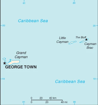
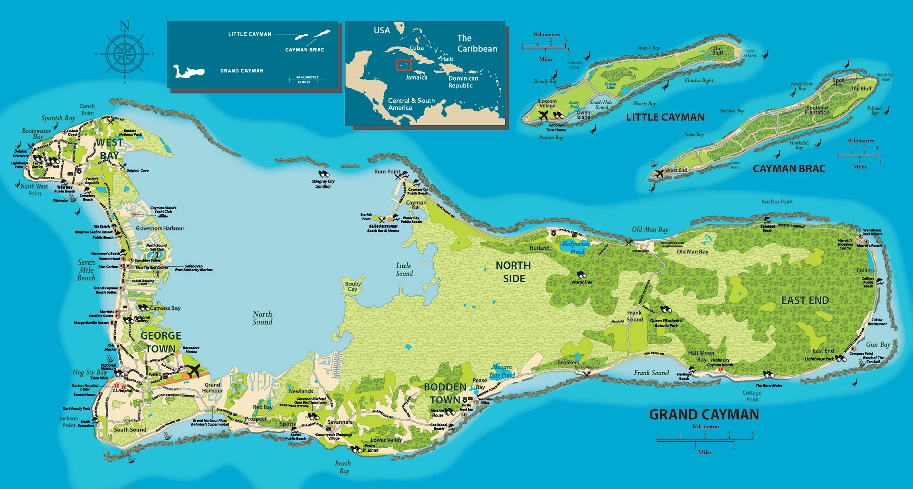
This state is located in the Caribbean, three-island group (Grand Cayman, Cayman Brac, Little Cayman) in the Caribbean Sea, 240 km south of Cuba and 268 km northwest of Jamaica, under the coordinates of 19 30 N, 80 30 W, covering an area of 264 sq km with a coastline of 160 km. Cayman Islands is 1.5 times the size of Washington, DC.
Low-lying limestone base surrounded by coral reefs, with 1 km SW of the bluff on Cayman Brac 50 m as the highest point of Cayman Islands, during the Caribbean Sea 0 m as the lowest point. With a total of 264 sq km, Cayman Islands has 264 sq km of land and 0 sq km water surface area.
An important location between Cuba and Central America.
The climate in the Cayman Islands is as follows: Tropical marine, warm, rainy summers (May to October), and calm, relatively dry winters (November to April).
The natural hazards shall be considered when you visit the Cayman Islands: Hurricanes (July to November).
The following major health-threatening issues shall be considered when visiting Cayman Islands: none.
Current environmental issues affecting the Caymanian people: no natural fresh water resources; drinking water supplies are met by reverse osmosis desalination plants and rainwater catchment; trash washing up on the beaches or being deposited there by residents; no recycling or waste treatment facilities; deforestation (trees being cut down to create space for commercial use).
Google Maps Cayman Islands
The capital and other divisions
Capital city: George Town (on Grand Cayman) found under the coordinates 19 18 N, 81 23 W, applying the time zone UTC-5 (same time as Washington, DC, during Standard Time), using the following daylight saving time: none.
George Town is one of the most popular tourist destinations in the Caribbean, and it’s easy to see why. The town is full of restaurants, bars, and shops. One reason that tourists flock there so often: George Town has a lot of English-speaking people.
Cayman Islands became independent on none (overseas territory of the UK), and its national holiday is Constitution Day, the first Monday in July (1959).
Administrative divisions: 6 districts; Bodden Town, Cayman Brac and Little Cayman, East End, George Town, North Side, West Bay.
People and society
The people living in this country are the Caymanian(s) (noun) or Caymanian (adjective) and belong mainly to the following ethnic groups: mixed 40%, White 20%, African descent 20%, expatriates of various ethnic groups 20%.
They speak English (official language) 90.9%, Spanish 4%, Filipino 3.3%, other 1.7%, unspecified 0.1% (2010 estimate) languages and practice the following religions: Protestant 67.8% (includes Church of God 22.6%, Seventh Day Adventist 9.4%, Presbyterian/United Church 8.6%, Baptist 8.3%, Pentecostal 7.1%, non-denominational 5.3%, Anglican 4.1%, Wesleyan Holiness 2.4%), Roman Catholic 14.1%, Jehovahs Witness 1.1%, other 7%, none 9.3%, unspecified 0.7% (2010 estimate).
We can conclude the following about the population in the Cayman Islands: The majority of the population resides on grand cayman. In the Cayman Islands, we are talking about 100% (2021) of the total population is living in cities, and most of them reside in the following municipalities: 35,000 George Town (capital city) (2018).
Industry
With no direct taxation, the islands are a thriving offshore financial center. More than 65,000 companies were registered in the Cayman Islands as of 2017, including more than 280 banks, 700 insurers, and 10,500 mutual funds. A stock exchange was opened in 1997. Nearly 90% of the island’s food and consumer goods must be imported. The Caymanians enjoy a standard of living comparable to that of Switzerland., Tourism is also a mainstay, accounting for about 70% of GDP and 75% of foreign currency earnings. The tourist industry is aimed at the luxury market and caters mainly to visitors from North America. Total tourist arrivals exceeded 2.1 million in 2016, with more than three-quarters of the US.
The Cayman Islands is rich in the following natural resources: Fish, climate, and beaches that foster tourism.
The main industrial sectors are typically tourism, banking, insurance and finance, construction, construction materials, furniture.
The country’s export sectors are particularly strong in recreational boats, gold, broadcasting equipment, sulfates, collector’s items (2019), partnering with these nations: Netherlands 82%, Spain 11% (2019). The export trade resulted in $4.13 billion. Note: Data are in current year dollars (2019 estimate). In a global export rank, values resulted in Cayman Islands’ position of 133.
Land use in the Cayman Islands: 52.9% (2018 estimate) forest, 35.9% (2018 estimate) other.
The arable land area is 0.8% (2018 estimate), and the agricultural land is 11.2% (2018 estimate). Land use for permanent crops 2.1% (2018 estimate), permanent pasture 8.3% (2018 estimate).
The main agro-industrial products of the Cayman Islands are vegetables, fruit; livestock; turtle farming.
The country typically needs to import: recreational boats, ships, gold, refined petroleum, cars (2019), partnering with the following nations: Netherlands 56%, United States 18%, Italy 8%, Switzerland 5% (2019) in a sum value of $2.7 billion. Note: data are in current year dollars (2019 estimate) $2.52 billion. Note: data are in current year dollars (2018 estimate). This sum value on the global ranking list of imports resulted in Cayman Islands 163.
Cayman Islands Driving Directions
In this post, you learned about the Cayman Islands, the Caribbean, three-island group (Grand Cayman, Cayman Brac, Little Cayman) in the Caribbean Sea, 240 km south of Cuba and 268 km northwest of Jamaica. We published some basic information about its capital George Town (on Grand Cayman), and the Caymanian nation.
Are you interested in visiting the Cayman Islands and looking for driving directions? Click here to plan your route, or see a printable road map of the Cayman Islands below for an overview of the route network.
Printable map of Cayman Islands
Did you know about Cayman Islands?
The Cayman Islands is a British Overseas Territory in the western Caribbean Sea that has been a popular destination for both business and tourism. Its size is quite large for an island nation, with over 100 sq km. The climate in the Cayman Islands is tropical and subtropical. It’s warm year-round, with temperatures never exceeding 29 degrees Celsius or falling below 20 degrees Celsius.
They are best known for being an offshore financial center with the oldest continuous law system in the Western Hemisphere.
After virtually visiting the Cayman Islands, you may also be interested in the neighboring countries: none.
If you liked our Google map and the Cayman Islands information page,
please share it with others or save the link https://www.drivingdirections.net in your bookmarks.