
North Korea Google Maps is a site/tool that offers a wide range of map views (topographic, satellite, street view) and navigation options, with little effort on your part, yet efficiently. If you need to plan a trip to a new place like North Korea, Google maps are available on desktop, mobile, or tablet. This Google maps and information page is dedicated to North Korea, Asia (22 countries), showing its location, country facts, details about its capital city Pyongyang, bordering countries like China, South Korea, Russia, and plenty of other information which may be interesting when you visit this Asian state.
Quick links: Google Maps North Korea, Pyongyang Google maps, Driving Directions North Korea, Printable Road Map.
About North Korea in a nutshell
- Conventional short form of the name: North Korea
- The conventional long form of the name: Democratic Peoples Republic of Korea,
- Local long form: Choson-minjujuui-inmin-konghwaguk
- Local short form: Choson
- Former name(s): N/A
- Etymology: derived from the Chinese name for Goryeo, which was the Korean dynasty that united the peninsula in the 10th century A.D.; the North Korean name Choson means Land of the Morning Calm.
- The legal system in North Korea: civil law system based on the Prussian model; system influenced by Japanese traditions and Communist legal theory.
- Climate: Continental. Warm summers and cold winters, especially in the north, where snow is common.
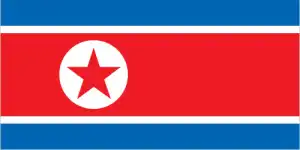
- The national symbols are red star, chollima (winged horse); national colors: red, white, blue.
- Internet TLD: .kp
After the Second World War, the great powers “temporarily” divided the 38th parallel in two: the northern part of the demarcated border was under the influence of the communist Soviet Union, and the southern part was under the influence of the United States. North Korea’s political system has left it far behind its southern neighbor in terms of tourism. The main attraction of Pyongyang, the capital city on both banks of the Tedong River, is the 150m-high water jet that rises from the middle of the river – the world’s tallest fountains. In the North, on the Chinese border, surrounded by deserted wilderness, rises the sacred mountain of the Koreans, the highest point on the Peninsula, the dormant volcano of Pektu-san, 2,744 meters high and covered in snow for most of the year. Legend has it that the son of the Lord of Heaven sowed the seeds of their kingdom from here. The first state in the region was the Kingdom of Goguryeo, which ruled northeast China and the northern half of the Korean Peninsula for almost a thousand years from the 3rd century BC: its mural tombs are almost the only surviving relics of this period. Of the more than 10 000 tombs, only 90 have been discovered to date, and about half of these are located in North Korea, around Pyongyang and Nampo. The tomb complex is the country’s only World Heritage Site, while South Korea boasts eight universal treasures.
Internet access is limited and restricted to the political elite.
Background
The first recorded kingdom (Choson) on the Korean Peninsula dates from approximately 2300 B.C. Over the subsequent centuries, three main kingdoms – Kogoryo, Paekche, and Silla – were established on the Peninsula. By the 5th century A.D, Kogoryo emerged as the most powerful, with control over much of the Peninsula, as well as part of Manchuria (modern-day northeast China). However, Silla allied with the Chinese to create the first unified Korean state in the late 7th century (688). Following the collapse of Silla in the 9th century, Korea was unified under the Koryo (Goryeo: 918-1392) and the Chosen (Joseon: 1392-1910) dynasties. Korea became the object of intense imperialistic rivalry between the Chinese (its traditional benefactor), Japanese, and Russian empires in the latter half of the 19th and early 20th centuries. Following the Sino-Japanese War (1894-95) and the Russo-Japanese War (1904-1905), Korea was occupied by Imperial Japan. In 1910, Japan formally annexed the entire Peninsula. After World War II, Korea was split, with the northern half coming under Soviet-sponsored communist control. After failing in the Korean War (1950-53) to conquer the US-backed Republic of Korea (ROK) in the southern portion by force, North Korea (Democratic Peoples Republic of Korea, DPRK), under its founder President KIM Il Sung, adopted a policy of ostensible diplomatic and economic self-reliance as a check against outside influence. The DPRK demonized the U.S. as the ultimate threat to its social system through state-funded propaganda and molded political, economic, and military policies around the core ideological objective of the eventual unification of Korea under Pyongyang’s control. KIM Il Sung’s son, KIM Jong Il, was officially designated as his father’s successor in 1980, assuming a growing political and managerial role until the elder Kim died in 1994. Under KIM Jong Ils rein, the DPRK continued developing nuclear weapons and ballistic missiles.
KIM Jong Un has publicly unveiled as his father’s successor in 2010. Following KIM Jong Ils’s death in 2011, KIM Jong Un quickly assumed power and has since occupied the regime’s highest political and military posts. After decades of economic mismanagement and resource misallocation, the DPRK, since the mid-1990s, has faced chronic food shortages and economic stagnation. In recent years, the North’s domestic agricultural production has increased but still falls far short of producing sufficient food to provide for its entire population. The DPRK began to ease restrictions to allow semi-private markets starting in 2002 but has made few other efforts to meet its goal of improving the overall standard of living. New economic development plans in the 2010s failed to meet government-mandated goals for vital industrial sectors, food production, or overall economic performance. In response, the DPRK leader in early 2021 admitted these failures but vowed to continue self-reliant policies. North Korea has a history of provocative regional military actions and posturing that are of significant concern to the international community and have limited the DPRK’s international engagement, particularly economically. These include the proliferation of military-related items. Long-range missile development WMD programs, including tests of nuclear devices in 2006, 2009, 2013, 2016, 2017, and large conventional armed forces. In 2013, the DPRK declared a policy of simultaneous development of its nuclear weapons program and economy.
In late 2017, KIM Jong-Un declared the North’s nuclear weapons development complete. In 2018, KIM announced a pivot towards diplomacy, including a re-prioritization of economic development, a pause in missile testing beginning in late 2017, and a refrain from anti-US rhetoric starting in June 2018. Since 2018, KIM has participated in four meetings with Chinese President XI Jinping, three with ROK President Moon Jae-in, and three with U.S. President TRUMP. Since 2019, North Korea has continued developing its ballistic missile program and issued statements condemning the U.S. and vowing to strengthen further its military capabilities, including long-range missiles and nuclear weapons. The DPRK remains one of the world’s most isolated and one of Asia’s poorest countries.
Geography
Mostly mountainous, with fertile plains in the southwest.
Separated from the democratic South by the worlds most heavily defended border, the Stalinist North Korean state has been isolated from the outside world since 1948.
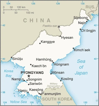
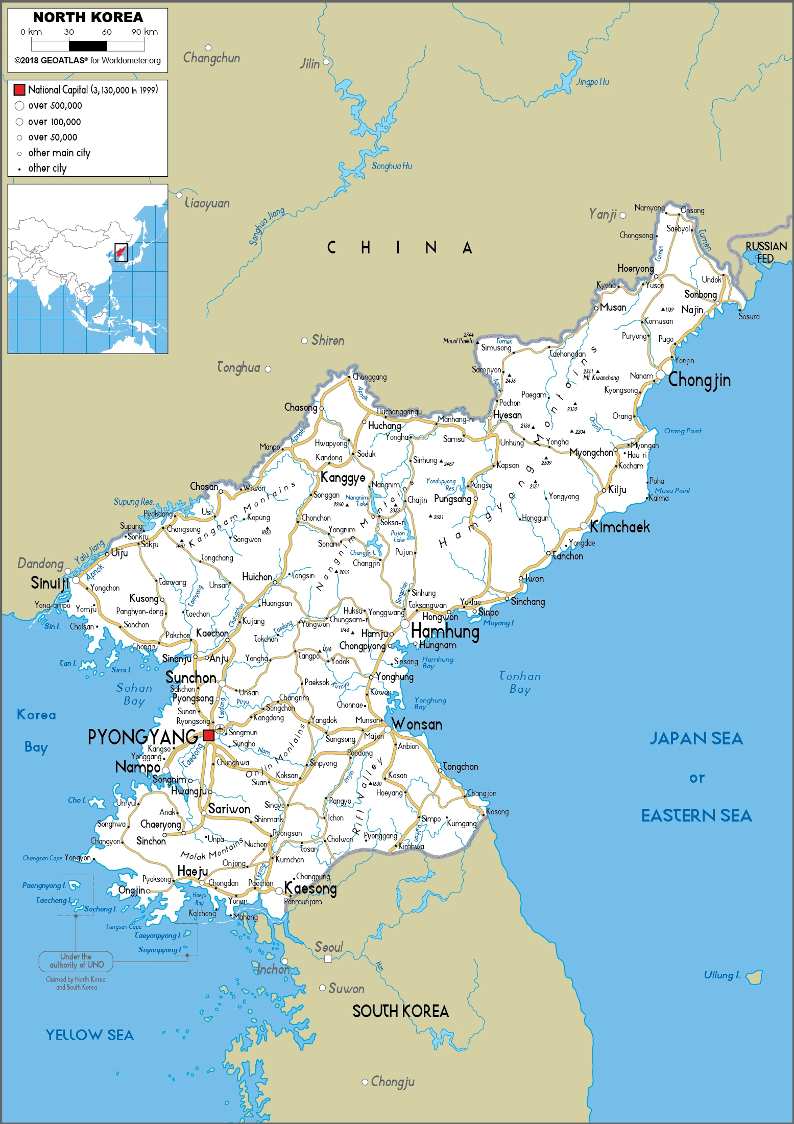
This state is located in Eastern Asia, the northern half of the Korean Peninsula bordering Korea Bay and the Sea of Japan, between China and South Korea, under the coordinates of 40 00 N, 127 00 E, covering an area of 120,538 sq km with a coastline of 2,495 km. North Korea is Slightly more significant than Virginia; slightly smaller than Mississippi.
North Korea has 1,607 km of land boundaries in total and borders (3 nations): China, 1352 km, South Korea, 237 km, Russia, 18 km.
Mostly hills and mountains separated by deep, narrow valleys, vast coastal plains in the west, discontinuous in the east, with Paektu-san 2,744 m as the highest point of North Korea, while the Sea of Japan 0 m as the lowest point, causing a mean elevation at 600 m throughout the country. With a total of 120,538 sq km, North Korea has 120,408 sq km of land and 130 sq km of water surface area.
Strategic location bordering China, South Korea, and Russia; the mountainous interior is isolated and sparsely populated.
The climate in North Korea is as follows: Temperate, with rainfall concentrated in summer, long, bitter winters.
When you visit North Korea, the natural hazards shall be considered: Late spring droughts often followed by severe flooding; occasional typhoons during the early fall volcanism: Changbaishan (2,744 m) (also known as Baitoushan, Baegdu, or Paektu-san), on the Chinese border, is considered historically active.
The following major health-threatening issues shall be considered when visiting North Korea: none.
Current environmental issues affecting the Korean people: water pollution, inadequate supplies of potable water, waterborne disease, deforestation, soil erosion, and degradation.
Google Maps North Korea
The capital and other divisions
Capital city: Pyongyang found under the coordinates 39 01 N, 125 45 E, applying the time zone UTC+9 (14 hours ahead of Washington, DC, during Standard Time), using the following daylight saving time: none.
This city is the capital of North Korea and has just over two million people. The population is very young, which mirrors North Korea’s general demographics. There are few trees in Pyongyang, and many buildings have been demolished to make way for new developments. The city is also thought to be the most polluted in the world, with a lot of mining and industrial processes taking place here and a large number of vehicles using outdated fuel.
North Korea became independent on 15 August 1945 (from Japan), and its national holiday is the Founding of the Democratic Peoples Republic of Korea (DPRK), 9 September (1948).
Administrative divisions: 9 provinces (do, singular and plural) and 3 cities (si, singular and plural) provinces: Chagang, Hambuk (North Hamgyong), Hamnam (South Hamgyong), Hwangbuk (North Hwanghae), Hwangnam (South Hwanghae), Kangwon, Pyongbuk (North Pyongan), Pyongnam (South Pyongan), Ryanggang, major cities: Nampo, Pyongyang, Rason, note: Nampo is sometimes designated as a metropolitan city, Pyongyang as a directly controlled city, and Rason as a city.
People and society
Life is heavily regulated. Cult of personality is more potent than the state-controlled religions, including Koreas own Chondogyo. Women are expected to work and run the home. The Korean Workers Party is the sole Party. Its elite has a privileged lifestyle. Globally condemned for nuclear weapons tests, the regime’s grip on power perpetuates its pariah status.
The population in North Korea is 25,831,360 (July 2021 estimate), with an average of 0.49% (2021 estimate) change. That means North Korea is the No. 54 in the world’s populated rank list. With an average of 34.6 years median age (33.2 years for males and 33.2 years for women), North Korea ranks No. 89 on the globe’s median age rank list.
The people living in this country are the Korean(s) (noun) or Korean (adjective) and belong mainly to the following ethnic groups: racially homogeneous; there is a small Chinese community and a few ethnic Japanese.
They speak the Korean language and practice the following religions: traditionally Buddhist and Confucianist, Christian and syncretic Chondogyo (Religion of the Heavenly Way). Note: autonomous religious activities are now almost nonexistent; government-sponsored religious groups exist to provide the illusion of religious freedom.
We can conclude the following about the population in North Korea: Population concentrated in the plains and lowlands. The least populated regions are the mountainous provinces adjacent to the Chinese border. The largest concentrations are in the western provinces, particularly the municipal district of Pyongyang and around Hungnam and Wonsan in the east. In North Korea, we are talking about 62.6% (2021) of the total population lives in cities, and most of them reside in the following municipalities: 3.108 million, Pyongyang (capital city) (2021).
Industry
Minerals are the only resource. Vital aid streams were lost with the global collapse of communism after 1989. Decades of economic mismanagement have led to chronic food shortages. Lack of fuel. Disproportionate defense budget.
One of the world’s most centrally directed and least open economies, North Korea faces chronic economic problems. The industrial capital stock is nearly beyond repair due to decades of mismanagement, underinvestment, shortages of spare parts, and poor maintenance. Corruption and resource misallocation, including show projects, large-scale military spending, and development of its ballistic missile and nuclear programs, severely draw off investment and civilian consumption resources. Industrial and power outputs have stagnated for years at a fraction of pre-1990 levels. Frequent weather-related crop failures aggravated chronic food shortages caused by ongoing systemic problems, including a lack of arable land, collective farming practices, poor soil quality, insufficient fertilization, and persistent shortages of tractors and fuel. The mid-1990s through mid-2000s were marked by severe famine and widespread starvation. The international community provided significant food aid through 2009. Since that time, food assistance has declined significantly. Domestic corn and rice production have improved in the last few years, although domestic production does not fully satisfy demand. A large portion of the population suffers from prolonged malnutrition and poor living conditions. Since 2002, the government has allowed semi-private markets to begin selling a more comprehensive range of goods, allowing North Koreans to make up for diminished public distribution system rations partially. It also implemented changes in the management process of communal farms to boost agricultural output.
In December 2009, North Korea carried out a redenomination of its currency, capping the amount of North Korean won exchanged for the new notes and limiting the exchange to a one-week window. A concurrent crackdown on markets and foreign currency use yielded severe shortages and inflation, forcing Pyongyang to ease the restrictions by February 2010. In response to the sinking of the South Korean warship Cheonan and the shelling of Yeonpyeong Island in 2010, the South Koreas government cut off most aid, trade, and bilateral cooperation activities. In February 2016, South Korea ceased its remaining bilateral economic activity by closing the Kaesong Industrial Complex in response to North Korea’s fourth nuclear test. This nuclear test and another in September 2016 resulted in two United Nations Security Council Resolutions that targeted North Korea’s foreign currency earnings, particularly coal and other mineral exports. Throughout 2017, North Korea’s continued nuclear and missile tests led to a tightening of U.N. sanctions, resulting in complete sectoral bans on DPRK exports and drastically limited vital imports. Over the last decade, China has been North Korea’s primary trading partner.
The North Korean Government continues to stress its goal of improving the overall standard of living but has taken few steps to make that goal a reality for its populace. In 2016, the regime used two mass mobilizations , one totaling 70 days and another 200 days , to spur the population to increase production and complete construction projects quickly. The regime released a five-year economic development strategy in May 2016 that outlined plans for promoting growth across sectors. Firm political control remains the government’s overriding concern, which likely will inhibit formal changes to North Korea’s current economic system.
North Korea is rich in the following natural resources: Coal, iron ore, limestone, magnesite, graphite, copper, zinc, lead, precious metals, and hydropower.
The main industrial sectors are military products, machine building, electric power, chemicals, mining (coal, iron ore, limestone, magnesite, graphite, copper, zinc, lead, and precious metals), and metallurgy; textiles, food processing; tourism.
The country’s export sectors are particularly strong in watch components, fake hair, iron alloys, instructional models, and tungsten (2019), partnering with these nations: China 67%, Suriname 6% (2019). The export trade resulted in $222 million. Note: Data are in current year dollars (2018 estimate). In a global rank of export, values resulted in North Korea’s position of 204.
Land use in North Korea: 46% (2018 estimate) forest, 32.2% (2018 estimate) other.
The arable land area is 19.5% (2018 estimate), and the agricultural land is 21.8% (2018 estimate). Land use for permanent crops 1.9% (2018 estimate), permanent pasture 0.4% (2018 estimate). The sum of the area of the irrigated land is 14,600 sq km (2012).
The main agro-industrial products of North Korea are rice, maize, vegetables, apples, potatoes, cabbages, fruit, sweet potatoes, beans, and soybeans.
The country typically needs to import: clothing and apparel, soybean oil, rice, wheat products, clocks/watches (2019), partnering with the following nations: China 96% (2019) in a sum value of $2.32 billion (2018 estimate) $3.86 billion (2016 estimate). This sum value on the global ranking list of imports resulted in North Korea 169.
North Korea Driving Directions
In this post, you learned about North Korea, Eastern Asia, the northern half of the Korean Peninsula bordering Korea Bay, and the Sea of Japan between China and South Korea. We published some basic information about its capital Pyongyang, and the Korean nation.
Are you interested in visiting North Korea and looking for driving directions? Click here to plan your route, or see a printable road map of North Korea below for an overview of the route network.
Printable map of North Korea
Did you know about North Korea?
North Korea is one of the most isolated countries in the world. One of its most significant distinctions is that the country has very little access to the internet. Many people don’t know that North Korea even exists.
North Korea has been on the map since 1948. It is located in East Asia and is bordered by China to the west, Russia to the North, South Korea to the east, and Japan to the South. It was once one of the poorest countries in Eastern Asia, but now it is one of the wealthiest. Recently, North Korean leader Kim Jong Un stated that he had achieved full nuclear capability.
After virtually visiting North Korea, you may also be interested in the neighboring countries: China, South Korea, and Russia.
If you liked our Google map and North Korea information page,
please share it with others or save the link https://www.drivingdirections.net in your bookmarks.