
The Northern Mariana Islands Google Maps is a site/tool that offers a wide range of map views (topographic, satellite, street view) and navigation options, with little effort on your part, yet efficiently. If you need to plan a trip to a new place like the Northern Mariana Islands, Google maps are available on desktop, mobile, or tablet. This Google maps and information page is dedicated to the Northern Mariana Islands, Oceania (27 countries), showing its location, country facts, details about its capital city Saipan, and plenty of other information which may be interesting when you visit this Oceanian state.
Quick links: Google Maps Northern Mariana Islands, Saipan Google maps, Driving Directions Northern Mariana Islands, Printable Road Map.
About Northern Mariana Islands in a nutshell
- Conventional short form of the name: Northern Mariana Islands
- The conventional long form of the name: Commonwealth of the Northern Mariana Islands
- Local long form: N/A
- Former name(s): Trust Territory of the Pacific Islands, Mariana Islands District
- Etymology: formally claimed and named by Spain in 1667 in honor of the Spanish Queen, MARIANA of Austria.
- The legal system in Northern Mariana Islands: the laws of the US apply, except for customs and some aspects of taxation.
- Climate: Tropical marine, moderated by northeast trade winds, little seasonal temperature variation, dry season from December to June, rainy season from July to October.
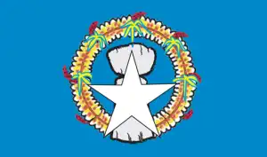
- The national symbols are latte stone; national colors: blue, white.
- Internet TLD: .mp
Background
The Northern Mariana Islands were settled by Austronesian people around 1500 B.C. These people became the indigenous Chamorro and were influenced by later migrations, including Micronesians in the first century A.D. and island Southeast Asians around 900. Spanish explorer Ferdinand MAGELLAN sailed through the Mariana Islands in 1521, and Spain claimed them in 1565. Spain formally colonized the Mariana Islands in 1668 and administered the archipelago from Guam. Spain’s brutal repression of Chamorro and new diseases and intermittent warfare reduced the indigenous population by about 90% in the 1700s. With a similar dynamic occurring on Guam, Spain forced Chamorro from the Northern Mariana Islands to resettle on Guam and prevented them from returning to their home islands. When the Northern Mariana Islands Chamorro returned, many other Micronesians, including Chuukese and Yapese, had already settled on their islands.
In 1898, Spain ceded Guam to the U.S. following the Spanish-American War but sold the Northern Mariana Islands to Germany under the German-Spanish Treaty of 1899. Germany administered the territory from German New Guinea but took a hands-off approach to day-to-day life. Following World War I, Japan administered the islands under a League of Nations mandate. Japan focused on sugar production and brought in thousands of Japanese laborers, who quickly outnumbered the Chamorro on the islands. During World War II, Japan invaded Guam from the Northern Mariana Islands and used Marianan Chamorro as translators with Guamanian Chamorro, creating friction between the two Chamorro communities that continues to this day. The U.S. captured the Northern Mariana Islands in 1944 after the Battle of Saipan and administered them post-World War II as part of the Trust Territory of the Pacific Islands (TTPI). On four occasions in the 1950s and 1960s, voters opted for integration with Guam, although Guam rejected it in 1969. In 1978, the Northern Mariana Islands were granted self-government separate from the rest of the TTPI. In 1986, islanders were granted U.S. citizenship, and the territory came under U.S. sovereignty as the Commonwealth of the Northern Mariana Islands (CNMI). In 2009, the CNMI became the final U.S. territory to elect a nonvoting delegate to the U.S. Congress.
Geography
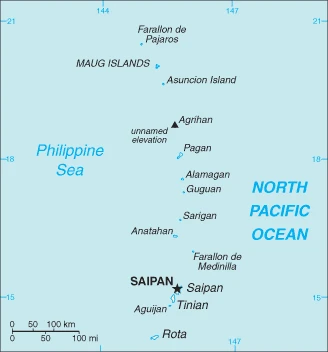
The Northern Mariana Islands is a group of islands in the Pacific Ocean, located in the middle of the Saipan, Tinian, and Rota archipelago. The total land area is 528 square miles. The Northern Mariana Islands are protected by U.S. legislation as American Samoa does not exist under international law. Still, it’s considered part of the United States for defense and foreign policy purposes.
This state is located in Oceania, islands in the North Pacific Ocean, about three-quarters of the way from Hawaii to the Philippines, under the coordinates of 15 12 N, 145 45 E, covering an area of 464 sq km with a coastline of 1,482 km. Northern Mariana Islands is 2.5 times the size of Washington, DC.
The southern islands in this north-south trending archipelago are limestone, with fringing coral reefs. The northern islands are volcanic, with active volcanoes on several islands, with Unnamed elevation on Agrihan 965 m as the highest point of Northern Mariana Islands, while Pacific Ocean 0 m as the lowest point. With a total of 464 sq km, the Northern Mariana Islands has 464 sq km of land and 0 sq km of water surface area.
Strategic location in the North Pacific Ocean.
The climate in the Northern Mariana Islands is as follows: Tropical marine, moderated by northeast trade winds, slight seasonal temperature variation, dry season from December to June, rainy season from July to October.
When you visit the Northern Mariana Islands, the natural hazards shall be considered: Active volcanoes on Pagan and Agrihan; typhoons (especially from August to November).
The following major health-threatening issues shall be considered when visiting the Northern Mariana Islands: none.
Current environmental issues affecting the people: contamination of groundwater on Saipan may contribute to disease; clean-up of landfill; protection of endangered species conflicts with development.
Google Maps Northern Mariana Islands
The capital and other divisions
Capital city: Saipan found under the coordinates 15 12 N, 145 45 E, applying the time zone UTC+10 (15 hours ahead of Washington, DC, during Standard Time), using the following daylight saving time: none.
Saipan is the capital of the Northern Mariana Islands, located in the Pacific Ocean. It has always been a strategic location for its location close to Japan, China, and Korea. In addition to being a prominent trading hub, Saipan plays an essential role in the defense and aerospace industries. It’s a popular destination for tourists visiting Japan and nearby countries like Guam.
Northern Mariana Islands became independent on none (Commonwealth in political union with the U.S.), and its national holiday is Commonwealth Day, 8 January (1978).
Administrative divisions: none (Commonwealth in political union with the U.S.); the U.S. Government defines no first-order administrative divisions, but there are 4 municipalities in the second order: Northern Islands, Rota, Saipan, and Tinian.
People and society
The population in the Northern Mariana Islands is 51,659 (July 2021 estimate), with an average of -0.36% (2021 estimate) change. That means the Northern Mariana Islands is the No. 209 in the world’s populated rank list. With an average of 32.8 years median age (31.8 years for males and 31.8 years for women), Northern Mariana Islands ranks No. 105 on the globe’s median age rank list.
The people living in this country are the NA (U.S. citizens) (noun) or N/A (adjective) and belong mainly to the following ethnic groups: Asian 50% (includes Filipino 35.3%, Chinese 6.8%, Korean 4.2%, and other Asian 3.7%), Native Hawaiian or other Pacific Islander 34.9% (includes Chamorro 23.9%, Carolinian 4.6%, and other Native Hawaiian or Pacific Islander 6.4%), other 2.5%, two or more ethnicities or races 12.7% (2010 estimate).
They speak Philippine languages 32.8%, Chamorro (official language) 24.1%, English (official language) 17%, other Pacific island languages 10.1% (including Carolinian (official language), Chinese 6.8%, other Asian languages 7.3%, other 1.9% (2010 estimate) languages and practice the following religions: Christian (Roman Catholic majority, although traditional beliefs and taboos may still be found).
We can conclude the following about the population of the Northern Mariana Islands: Approximately 90% of the population lives on the island of Saipan. In the Northern Mariana Islands, we are talking about 91.9% (2021) of the total population is living in cities, and most of them reside in the following municipalities: 51,000 Saipan (capital city) (2018).
Industry
The Commonwealth of the Northern Mariana Islands(CNMI) economy has been on the rebound in the last few years, mainly on the strength of its tourism industry. In 2016, the CNMI’s real GDP increased 28.6% over the previous year, following two years of relatively rapid growth in 2014 and 2015. Chinese and Korean tourists have supplanted Japanese tourists in the last few years. The Commonwealth is making a concerted effort to broaden its tourism by extending casino gambling from the small Islands of Tinian and Rota to the main Island of Saipan, its political and commercial center. Investment is concentrated on hotels and casinos in Saipan, the CNMIs largest island and home to about 90% of its population. Federal grants have also contributed to economic growth and stability. In 2016, federal grants amounted to $101.4 billion, which made up 26% of the CNMI government’s total revenues. A small agriculture sector consists of cattle ranches and small farms producing coconuts, breadfruit, tomatoes, and melons. Legislation is pending in the U.S. Congress to extend the transition period to allow foreign workers to work in the CNMI on temporary visas.
The Northern Mariana Islands are rich in the following natural resources: Arable land and fish.
The main industrial sectors are typically tourism, banking, construction, fishing, handicrafts, and other services.
The country’s export sectors are particularly strong in scrap iron, copper, aluminum, computers, and laboratory diagnostic equipment (2019), partnering with these nations: South Korea 73%, Peru 5% (2019). The export trade resulted in $914 million. Note: Data are in current year dollars (2016 estimate). In a global rank of the export, values resulted in the Northern Mariana Islands’ position of 180.
Land use in the Northern Mariana Islands: 65.5% (2018 estimate) forest, 27.9% (2018 estimate) other.
The arable land area is 2.2% (2018 estimate), and the agricultural land is 6.6% (2018 estimate). Land use for permanent crops 2.2% (2018 estimate), permanent pasture 2.2% (2018 estimate). The sum of the area of the irrigated land is 1 sq km (2012).
The main agro-industrial products of the Northern Mariana Islands are vegetables and melons, fruits and nuts; ornamental plants; livestock, poultry, eggs; fish and aquaculture products.
The country typically needs to import: refined petroleum, trunks/cases, cars, watches, jewelry (2019), partnering with the following nations: Hong Kong 29%, Japan 29%, Singapore 16%, South Korea 9% (2019) in a sum value of $893 million (2016 estimate) $638 million (2015 estimate). This sum value on the global ranking list of imports resulted in Northern Mariana Islands 194.
Northern Mariana Islands Driving Directions
In this post, you learned about the Northern Mariana Islands, Oceania, islands in the North Pacific Ocean, about three-quarters from Hawaii to the Philippines. We published some basic information about its capital Saipan, and the country’s nation.
Are you interested in visiting the Northern Mariana Islands and looking for driving directions? Click here to plan your route, or see a printable road map of the Northern Mariana Islands below for an overview of the route network.
Printable map of Northern Mariana Islands

Did you know about Northern Mariana Islands?
The Northern Mariana Islands is a United States Commonwealth in the Western Pacific Ocean. The Northern Mariana Islands are located north of Guam and south of Japan. The first known inhabitants were of Filipino descent. Around 51,000 people live on the islands, with most residing on Saipan and Tinian. English is the official language, but Chamorro, Tagalog, and Arabic are also spoken among a minority.
After virtually visiting the Northern Mariana Islands, you may also be interested in the neighboring country: The United States.
If you liked our Google map and the Northern Mariana Islands information page,
please share it with others or save the link https://www.drivingdirections.net in your bookmarks.