
New Caledonia Google Maps is a site/tool that offers a wide range of map views (topographic, satellite, street view) and navigation options, with little effort on your part, yet efficiently. If you need to plan a trip to a new place like New Caledonia, Google maps are available on desktop, mobile, or tablet. This Google maps and information page is dedicated to New Caledonia, Oceania (27 countries), showing its location, country facts, details about its capital city Noumea, and plenty of other information which may be interesting when you visit this Oceanian state.
Quick links: Google Maps New Caledonia, Noumea Google maps, Driving Directions New Caledonia, Printable Road Map.
About New Caledonia in a nutshell
- Conventional short form of the name: New Caledonia
- The conventional long form of the name: Territory of New Caledonia and Dependencies
- Local long form: Territoire des Nouvelle-Caledonie et Dependances
- Local short form: Nouvelle-Caledonie
- Former name(s): N/A
- Etymology: British explorer Captain James COOK discovered and named New Caledonia in 1774; he used the appellation because the northeast of the island reminded him of Scotland (Caledonia is the Latin designation for Scotland).
- The legal system in New Caledonia: civil law system based on French civil law.
- Climate: Tropical, modified by southeast trade winds, hot, humid.
- The national symbols are fleche faitiere (native rooftop adornment), kagu bird; national colors: gray, red.
- Internet TLD: .nc
New Caledonia is located in the Southwest Pacific Ocean. It’s now a full member of the U.N., and its population makes up 20% of the world’s Kanak people. New Caledonia is also known for its natural resources, including nickel, gold, and other minerals. It is named after one of the Scottish king’s wives, Lady Helen, who was the daughter of James Gordon. The country’s native languages are French and Kanak, but English is also standard. New Caledonia is home to whale watching tours and various species of coral reefs.
Background
The first humans settled in New Caledonia around 1600 B.C. The Lapita were skilled navigators, and evidence of their pottery around the Pacific has served as a guide for understanding human expansion in the region. Successive waves of migrants from other islands in Melanesia intermarried with the Lapita, giving rise to the Kanak ethnic group considered indigenous to New Caledonia. British explorer James COOK was the first European to visit New Caledonia in 1774, giving it the Latin name for Scotland. Missionaries first landed in New Caledonia in 1840. In 1853, France annexed New Caledonia to preclude any British attempt. France declared it a penal colony in 1864 and sent more than 20,000 prisoners to New Caledonia in the ensuing three decades. Nickel was discovered in 1864, and French prisoners were directed to mine it. France brought in indentured servants and enslaved labor from elsewhere in Southeast Asia to work the mines, blocking Kanaks from accessing the most profitable part of the local economy. In 1878, High Chief ATAI led a rebellion against French rule. The Kanaks were relegated to reservations, leading to periodic more minor uprisings and culminating in a significant revolt in 1917 that was brutally suppressed by colonial authorities.
During World War II, New Caledonia became a substantial base for Allied troops, and the U.S. moved its South Pacific headquarters to the island in 1942. Following the war, New Caledonia was made an overseas territory, and French citizenship was granted to all inhabitants in 1953, thereby permitting the Kanaks to move off the reservations. The Kanak nationalist movement began in the 1950s, but most voters chose to remain a territory in an independence referendum in 1958. The European population of New Caledonia boomed in the 1970s with a renewed focus on nickel mining, reigniting Kanak nationalism. Key Kanak leaders were assassinated in the early 1980s, leading to escalating violence and dozens of fatalities. The Matignon Accords of 1988 provided for a 10-year transition period. The Noumea Accord of 1998 transferred an increasing amount of governing responsibility from France to New Caledonia over 20 years and provided three independence referenda. In the first held in 2018, voters rejected independence by 57 to 43 percent. In the second held in 2020, voters rejected 53 to 47 percent independence. A third referendum is planned for December 2021. In February 2021, pro-independence parties gained a majority in the New Caledonian Government for the first time.
Geography
New Caledonia is an independent nation in the region of Oceania, a French overseas territory. With a history of European settlement dating back to the 16th century, this island country boasts two official languages: French and English.
This state is located in Oceania, islands in the South Pacific Ocean, east of Australia, under the coordinates of 21 30 S, 165 30 E, covering an area of 18,575 sq km with a coastline of 2,254 km. New Caledonia is Slightly smaller than New Jersey.
Coastal plains with interior mountains, with Mont Panie 1,628 m as the highest point of New Caledonia, while Pacific Ocean 0 m as the lowest point, causing a mean elevation at N/A throughout the country. With 18,575 sq km, New Caledonia has 18,275 sq km of land and 300 sq km of water surface area.
Consists of the main island of New Caledonia (one of the largest in the Pacific Ocean), the archipelago of Iles Loyaute, and numerous small, sparsely populated islands and atolls.
The climate in New Caledonia is tropical, modified by southeast trade winds, hot, humid.
When you visit New Caledonia, the natural hazards shall be considered: Cyclones, most frequent from November to march, volcanism: Matthew and Hunter Islands are historically active.
The following major health-threatening issues shall be considered when visiting New Caledonia: degree of risk: high (2020), bacterial diarrhea, malaria.
Current environmental issues affecting the New Caledonian people: preservation of coral reefs; prevention of invasive species; limiting erosion caused by nickel mining and forest fires.
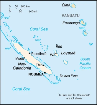
Google Maps New Caledonia
The capital and other divisions
Capital city: Noumea found under the coordinates 22 16 S, 166 27 E, applying the time zone UTC+11 (16 hours ahead of Washington, DC, during Standard Time), using the following daylight saving time: none.
Noumea, the capital of Nouvelle-Calédonie, is a beautiful city on the north side of New Caledonia. One of its most famous attractions is the “Jardin Exotique,” which is a botanical garden with trees and plants from around the world. Besides this, hiking and kayaking are popular things to do in Noumea because of the many beautiful beaches.
New Caledonia never became independent. It is one of the overseas collectivities of France, and its national holiday is Fete de la Federation, 14 July (1790).
Administrative divisions: 3 provinces; Province Iles (Islands Province), Province Nord (North Province), and Province Sud (South Province).
People and society
The population in New Caledonia is 293,608 (July 2021 estimate), with an average of 1.22% (2021 estimate) change. That means New Caledonia is the No. 182 in the world’s populated rank list. With an average of 32.9 years median age (32.1 years for males and 32.1 years for women), New Caledonia ranks No. 103 on the globe’s median age rank list.
The people living in this country are the New Caledonian(s) (noun) or New Caledonian (adjective) and belong mainly to the following ethnic groups: Kanak 39.1%, European 27.1%, Wallisian, Futunian 8.2%, Tahitian 2.1%, Indonesian 1.4%, Ni-Vanuatu 1%, Vietnamese 0.9%, other 17.7%, unspecified 2.5% (2014 estimate).
They speak French (official language), 33 Melanesian-Polynesian dialects languages, and practice the following religions: Roman Catholic 60%, Protestant 30%, other 10%.
We can conclude the following about the population in New Caledonia: Most of the populace lives in the southern part of the main island, in and around the capital of Noumea. In New Caledonia, we are talking about 71.9% (2021) of the total population is living in cities, and most of them reside in the following municipalities: 198,000 Noumea (capital city) (2018).
Industry
New Caledonia has 11% of the world’s nickel reserves, representing the second-largest reserves on the planet. Only a tiny amount of the land is suitable for cultivation, and food accounts for about 20% of imports. In addition to nickel, substantial financial support from France – equal to more than 15% of GDP – and tourism are keys to the health of the economy., With the gradual increase in the production of two new nickel plants in 2015, the average production of metallurgical goods stood at a record level of 94 thousand tons. However, the sector is exposed to the high volatility of nickel prices, which declined since 2016. In 2017, one of the three major mining firms on the island, Vale, put its operations up for sale, triggering concerns of layoffs ahead of the 2018 independence referendum.
New Caledonia is rich in the following natural resources: Nickel, chrome, iron, cobalt, manganese, silver, gold, lead, and copper.
The main industrial sectors are typically nickel mining and smelting.
The country’s export sectors are particularly strong in iron alloys, nickel, cobalt, carbonates, and essential oils (2019), partnering with China 59%, South Korea 14%, and Japan 11% (2019). The export trade resulted in $2.207 billion. Note: Data are in current year dollars (2014 estimate). In a global rank of the export, values resulted in New Caledonia’s position of 152.
Land use in New Caledonia: 45.9% (2018 estimate) forest, 43.7% (2018 estimate) other.
The arable land area is 0.4% (2018 estimate), and the agricultural land is 10.4% (2018 estimate). Land use for permanent crops 0.2% (2018 estimate), permanent pasture 9.8% (2018 estimate). The sum of the area of the irrigated land is 100 sq km (2012).
The main agro-industrial products of New Caledonia are coconuts, vegetables, maize, fruit, beef, pork, potatoes, bananas, eggs, and yams.
The country typically needs to import: refined petroleum, aircraft, coal, cars, packaged medicines (2019), partnering with the following nations: France 43%, Australia 12%, Singapore 12%, China 6% (2019) in a sum value of $2.715 billion (2015 estimate) $4.4 billion (2014 estimate). This sum value on the global ranking list of imports resulted in New Caledonia 162.
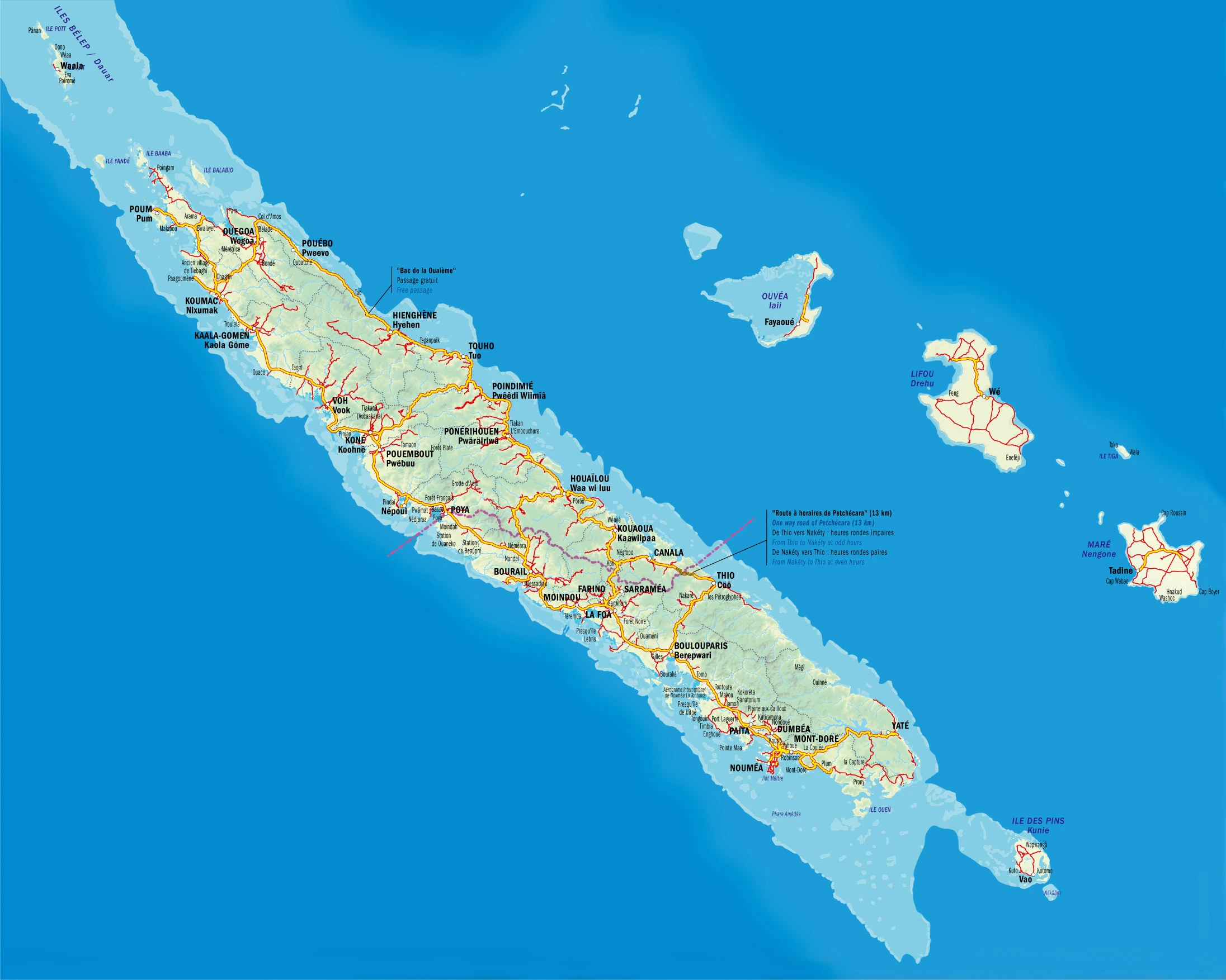
New Caledonia Driving Directions
In this post, you learned about New Caledonia, in the South Pacific Ocean, east of Australia. We published some basic information about its capital Noumea, and the New Caledonian nation.
Are you interested in visiting New Caledonia and looking for driving directions? Click here to plan your route, or see a printable road map of New Caledonia below for an overview of the route network.
Printable map of New Caledonia
Did you know about New Caledonia?
New Caledonia is a small, self-governing territory of France in the southwest Pacific composed of the main island of Grand Terre and several smaller islands. The country has an estimated population of 195,000, with the majority being indigenous Melanesian or Polynesian people.
After virtually visiting New Caledonia, you may also be interested in the neighboring countries: none.
If you liked our Google map and New Caledonia information page,
please share it with others or save the link https://www.drivingdirections.net in your bookmarks.