
Federated States of Micronesia Google Maps is a site/tool that offers a wide range of map views (topographic, satellite, street view) and navigation options, with little effort on your part, yet efficiently. If you need to plan a trip to a new place like the Federated States of Micronesia, Google maps are available on desktop, mobile, or tablet. This Google maps and information page is dedicated to Federated States of Micronesia, Oceania (27 countries), showing its location, country facts, details about its capital city Palikir, bordering countries, and plenty of other information which may be interesting when you visit this Oceanian state.
Quick links: Google Maps Federated States of Micronesia, Palikir Google maps, Driving Directions Federated States of Micronesia, Printable Road Map.
About Federated States of Micronesia in a nutshell
- Chuuks lagoon contains the sunken wrecks of over 100 Japanese ships and 270 planes from World War II.
- Conventional short form of the name: none
- The conventional long form of the name: Federated States of Micronesia
- Local long form: Federated States of Micronesia
- Local short form: none
- Former name(s): New Philippines; Caroline Islands; Trust Territory of the Pacific Islands, Ponape, Truk, and Yap Districts
- Etymology: the term Micronesia is a 19th-century construct of two Greek words, micro (small) and nesoi (islands), and refers to thousands of small islands in the western Pacific Ocean.
- The legal system in Federated States of Micronesia: mixed legal system of common and customary law.
- Climate: Tropical, with high humidity. There is very heavy rainfall outside the January March dry season.
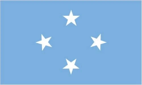
- The national symbols are four, five-pointed, white stars on a light blue field, hibiscus flower; national colors: light blue, white.
- Internet TLD: .fm
Background
Each of the four states that comprise the Federated States of Micronesia (FSM) – Chuuk, Kosrae, Pohnpei, and Yap – has its unique history and cultural traditions. The first humans arrived in the FSM in the second millennium B.C. In the 800s A.D., construction of the artificial islets at the Nan Madol complex in Pohnpei began, with the leading architecture being built around 1200. At its height, Nan Madol united the approximately 25,000 people of Pohnpei under the Saudeleur Dynasty. Around the same time, Kosrae was united in a kingdom centered in Leluh by 1250. Yaps society became strictly hierarchical, with chiefs receiving tributes from islands up to 1,100 km (700 mi) away. Widespread human settlement in Chuuk began in the 1300s, and the different islands in the Chuuk Lagoon were frequently at war with one another. Portuguese and Spanish explorers visited a few of the islands in the 1500s, and Spain began exerting nominal, but not day-to-day, control over some of the islands – which they named the Caroline Islands – in the 1600s. Christian missionaries arrived in the 1800s, in particular to Chuuk and Kosrae. By the 1870s, nearly every Kosraean had converted to Christianity, and religion continued to play an essential role in daily life on the island. In 1899, Spain sold all of the FSM to Germany.
Japan seized the islands in 1914 and was granted a League of Nations mandate to administer them in 1920. The Japanese navy built bases across most islands and headquartered their Pacific naval operations in Chuuk. The U.S. bombed Chuuk in 1944 during Operation Hailstone in World War II, destroying 250 Japanese planes and 40 ships. The U.S. military largely bypassed the other islands in its leapfrog campaign across the Pacific. The FSM came under U.S. administration as part of the Trust Territory of the Pacific Islands in 1947, which comprised six districts: Chuuk, the Marshall Islands, the Northern Mariana Islands, Palau, Pohnpei, and Yap. Kosrae was separated from Pohnpei into a separate district in 1977.
In 1979, Chuuk, Kosrae, Pohnpei, and Yap ratified the FSM Constitution and declared independence, while the other three districts opted to pursue separate political statuses. In 1982, the FSM signed a Compact of Free Association (COFA) with the U.S., which granted the FSM financial assistance and access to many U.S. domestic programs in exchange for exclusive U.S. military access and defense responsibilities. The COFA entered into force in 1986, and its funding was renewed in 2003. There are significant inter-island rivalries stemming from their different histories and cultures. Chuuk, the most populous but poorest state, is planning an independence referendum for 2022. Eligible Micronesians can live, work, and study in any part of the U.S., and its territories without a visa – this privilege reduces stresses on the island economy and the environment. Micronesians serve in the U.S. armed forces, and military recruiting from the FSM, per capita, is higher than many U.S. states.
Geography
A mixture of high volcanic islands with forested interiors and low-lying coral atolls. Some of the islands have coastal mangrove swamps.
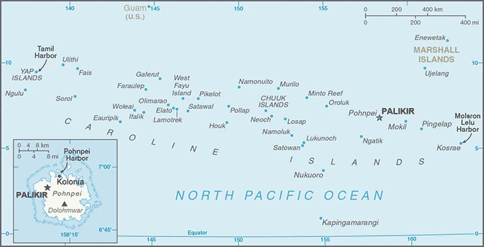
The Federated States of Micronesia is an archipelago of over 600 islands and atolls in the North Pacific Ocean. It has a total land area of 2,883 square kilometers and is the most populous nation in the Federated States of Micronesia, with a population of approximately 94,000 people.
This state is located in Oceania, an island group in the North Pacific Ocean, about three-quarters of the way from Hawaii to Indonesia, under the coordinates of 6 55 N, 158 15 E, covering an area of 702 sq km with a coastline of 6,112 km. Federated States of Micronesia is Four times the size of Washington, DC (land area only).
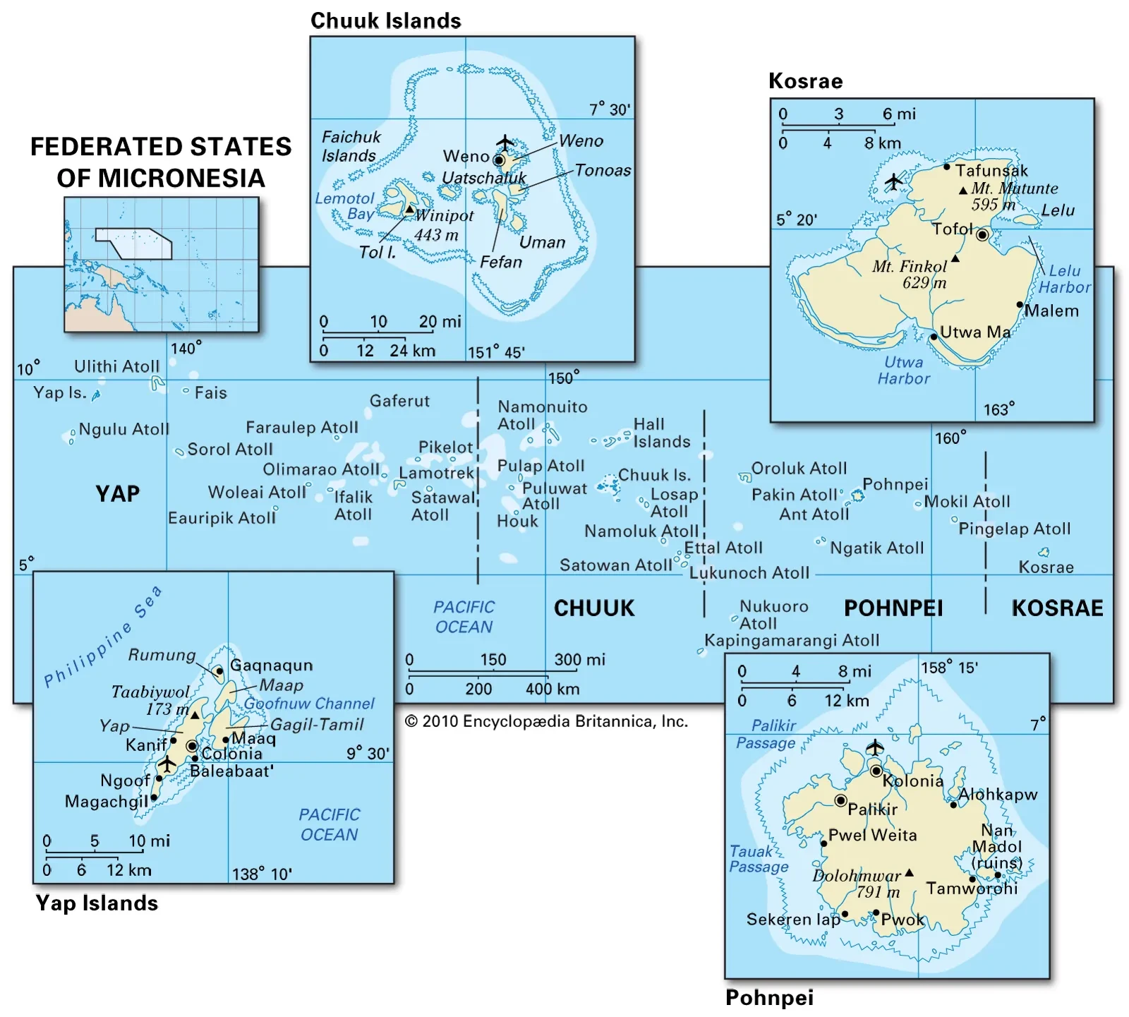
Islands vary geologically from high mountainous islands to low, coral atolls, volcanic outcroppings on Pohnpei, Kosrae, and Chuuk, with Nanlaud on Pohnpei 782 m as the highest point of Federated States of Micronesia, while Pacific Ocean 0 m as the lowest point, causing a mean elevation at N/A throughout the country. With a total of 702 sq km, the Federated States of Micronesia has 702 sq km of land and 0 sq km (freshwater only) water surface area.
Composed of four major island groups totaling 607 islands.
The climate in the Federated States of Micronesia is as follows: Tropical, heavy year-round rainfall, especially in the eastern islands, located on the southern edge of the typhoon belt with occasionally severe damage.
When you visit the Federated States of Micronesia, the natural hazards shall be considered: Typhoons from June to December.
The following major health-threatening issues shall be considered when visiting the Federated States of Micronesia: degree of risk: high (2020), bacterial diarrhea, malaria, leptospirosis and schistosomiasis, rabies, meningococcal meningitis, Lassa fever.
Current environmental issues affecting the Micronesian; Chuukese, Kosraen(s), Pohnpeian(s), Yapese people: overfishing; climate change; water pollution, toxic pollution from mining; solid waste disposal.
Google Maps Federated States of Micronesia
The capital and other divisions
Capital city: Palikir found under the coordinates 6 55 N, 158 09 E, applying the time zone UTC+11 (16 hours ahead of Washington, DC, during Standard Time), using the following daylight saving time: none.
Palikir is the capital of the Federated States of Micronesia. It is located on the west side of Pohnpei Island, built by Japanese colonists.
Federated States of Micronesia became independent on 3 November 1986 (from the US-administered UN trusteeship), and its national holiday is Constitution Day, 10 May (1979).
Administrative divisions: 4 states; Chuuk (Truk), Kosrae (Kosaie), Pohnpei (Ponape), Yap.
People and society
Micronesians are physically, culturally, and linguistically diverse. Melanesians live on Yap, Polynesians in Pohnpei. The supply of electricity and running water is limited. Society is based on matrilineal clans.
The Federated States of Micronesia population is 101,675 (July 2021 estimate), with an average of -0.64% (2021 estimate) change. That means the Federated States of Micronesia is No. 193 in the world’s populated rank list. With an average of 26.3 years median age (25.5 years for males and 25.5 years for women), the Federated States of Micronesia ranks No. 154 on the globe’s median age rank list.
The people living in this country are the Micronesian(s) (noun) or Micronesian; Chuukese, Kosraen(s), Pohnpeian(s), Yapese (adjective) and belong mainly to the following ethnic groups: Chuukese/Mortlockese 49.3%, Pohnpeian 29.8%, Kosraean 6.3%, Yapese 5.7%, Yap outer islanders 5.1%, Polynesian 1.6%, Asian 1.4%, other 0.8% (2010 estimate).
They speak English (official language and common language), Chuukese, Kosrean, Pohnpeian, Yapese, Ulithian, Woleaian, Nukuoro, Kapingamarangi languages and practice the following religions: Roman Catholic 54.7%, Protestant 41.1% (includes Congregational 38.5%, Baptist 1.1%, Seventh Day Adventist 0.8%, Assembly of God 0.7%), Church of Jesus Christ 1.5%, other 1.9%, none 0.7%, unspecified 0.1% (2010 estimate).
We can conclude the following about the population in the Federated States of Micronesia: The majority of the population lives in the coastal areas of the high islands. The mountainous interior is largely uninhabited. Less than half of the population lives in urban areas. In the Federated States of Micronesia, we are talking about 23.1% (2021) of the total population is living in cities, and most of them reside in the following municipalities: 7,000 Palikir (capital city) (2018).
Industry
Dependent on U.S. aid. Fishing licenses are a vital source of foreign revenue. Tourism, fishing, betel nuts, copra are economic mainstays. Trust fund created to reduce aid reliance.
Economic activity consists mainly of subsistence farming, fishing, and government, employing two-thirds of the adult working population and receiving largely 58% in 2013 from Compact of Free Association assistance provided by the U.S. The islands have few commercially valuable mineral deposits. The tourism potential is limited by isolation, lack of adequate facilities, and limited internal air and water transportation.
Under the terms of the original Compact, the U.S. provided $1.3 billion in grants and aid from 1986 to 2001. The U.S. and the Federated States of Micronesia (FSM) negotiated a second (amended) Compact agreement in 2002-03 that took effect in 2004. The amended Compact runs for 20 years to 2023, during which the U.S. will provide roughly $2.1 billion to the FSM. The amended Compact also develops a trust fund for the FSM to provide a comparable income stream beyond 2024 when Compact grants end. The country’s medium-term economic outlook appears fragile because of its dependence on U.S. assistance and the lackluster performance of its small and stagnant private sector.
The Federated States of Micronesia is rich in the following natural resources: Timber, marine products, deep-seabed minerals, phosphate.
The main industrial sectors are tourism, construction, specialized aquaculture, craft items (shell and wood).
The country’s export sectors are particularly strong in fish and fish products, coral/shells, scrap metals, mollusks, office machinery/parts (2019), partnering with these nations: Thailand 73%, Japan 10%, China 9% (2019). The export trade resulted in $88.3 million. Note: Data are in current year dollars (2013 estimate). In a global rank of the export, values resulted in Federated States of Micronesia’s position of 211.
Land use in Federated States of Micronesia: 74.5% (2018 estimate) forest, 0% (2018 estimate) other.
The arable land area is 2.3% (2018 estimate), and the agricultural land is 25.5% (2018 estimate). Land use for permanent crops 19.7% (2018 estimate), permanent pasture 3.5% (2018 estimate). The sum of the area of the irrigated land is 0 sq km NA (2012).
The main agro-industrial products of Federated States of Micronesia are coconuts, cassava, vegetables, sweet potatoes, bananas, pork, plantains, fruit, eggs, beef.
The country typically needs to import: poultry meats, netting, broadcasting equipment, various meats, fish products (2019), partnering with the following nations: the United States 32%, China 16%, Japan 14%, Taiwan 9%, Philippines 6%, South Korea 6% (2019) in a sum value of $167.8 million (2015 estimate) $258.5 million (2013 estimate). This sum value on the global ranking list of imports resulted in Federated States of Micronesia 215.
Federated States of Micronesia Driving Directions
In this post, you learned about the Federated States of Micronesia, Oceania, island group in the North Pacific Ocean, about three-quarters of the way from Hawaii to Indonesia. We published some basic information about its capital Palikir, and the Micronesian; Chuukese, Kosraen(s), Pohnpeian(s), Yapese nation.
Are you interested in visiting the Federated States of Micronesia and looking for driving directions? Click here to plan your route, or see a printable road map of Federated States of Micronesia below for an overview of the route network.
Printable map of Federated States of Micronesia
Did you know about Federated States of Micronesia?
The Federated States of Micronesia was first mentioned in the Mariana journal “Balam” in 1602. It was called “Mosilikatla,” meaning “two parts”.
After virtually visiting the Federated States of Micronesia, you may also be interested in the neighboring countries: Papua New Guinea, Palau, Marshall Islands, Nauru, or the Solomon Islands.
If you liked our Google map and the Federated States of Micronesia information page,
please share it with others or save the link https://www.drivingdirections.net in your bookmarks.