
American Samoa Google Maps is a site/tool that offers a wide range of map views (topographic, satellite, street view) and navigation options, with little effort on your part, yet efficiently. If you need to plan a trip to a new place like American Samoa, Google maps are available on desktop, mobile, or tablet. This Google maps and information page is dedicated to American Samoa, Oceania (27 countries), showing its location, country facts, details about its capital city Pago Pago, bordering countries like none, and plenty of other information which may be interesting when you visit this Oceanian state.
Quick links: Google Maps American Samoa, Pago Pago Google maps, Driving Directions American Samoa, Printable Road Map.
About American Samoa in a nutshell
- Conventional short form of the name: American Samoa
- The conventional long form of the name: American Samoa
- Etymology: the meaning of Samoa is disputed; some modern explanations are that the sa connotes sacred and moa indicates center, so the name can mean Holy Center; alternatively, some assertions state that it can mean place of the sacred moa bird of Polynesian mythology; the name, however, may go back to Proto-Polynesian (PPn) times (before 1000 B.C.); a plausible PPn reconstruction has the first syllable as saa meaning tribe or people and moa meaning deep sea or ocean to convey the meaning people of the deep sea.
- The legal system in American Samoa: mixed legal system of US common law and customary law.
- Climate: A tropical climate all year round with two distinct seasons; the wet and dry season. The wet season is usually between December and March and the dry season from April through to September with the average daily temperature around 81–83 °F (27–28 °C) all year round.
- The national symbols are a fue (coconut fiber fly whisk; representing wisdom) crossed with a tootoo (staff; representing authority); national colors: red, white, blue.
- Internet TLD: .as
Background
Tutuila was settled by 1000 B.C., and the island served as a refuge for exiled chiefs and defeated warriors from the other Samoan islands. The Manua Islands developed its traditional chiefdom that maintained its autonomy by controlling oceanic trade. In 1722, Dutch explorer Jacob ROGGEVEEN was the first European to sail through the Manua Islands, and he was followed by French explorer Louis Antoine DE BOUGAINVILLE in 1768. Whalers and missionaries arrived in American Samoa in the 1830s. Still, American and European traders tended to favor the port in Apia – now in independent Samoa – over the smaller and less-developed Pago Pago on Tutuila. In the mid-1800s, a dispute arose in Samoa over control of the Samoan archipelago, with different chiefs gaining support from Germany, the U.K., and the U.S. In 1872, the high chief of Tutuila offered the U.S. exclusive rights to Pago Pago in return for U.S. protection, but the U.S. rejected this offer.
As fighting resumed, the U.S. agreed to the chief’s request in 1878 and set up a coaling station at Pago Pago. In 1899, with continued disputes over succession, Germany and the U.S. agreed to divide the Samoan islands, while the U.K. withdrew its claims in exchange for parts of the Solomon Islands. Local chiefs on Tutuila formally ceded their land to the U.S. in 1900, followed by the chief of Manua in 1904. The territory was officially named American Samoa in 1911. The U.S. administered the territory through the Department of the Navy. In 1918, the naval governor instituted strict quarantine rules to prevent the spread of the Spanish flu, allowing American Samoa to avoid the deadly infection that ravaged the then-New Zealand administered territory of Samoa. In 1949, there was an attempt to organize the territory, granting it formal self-government, but local chiefs helped defeat the measure in the U.S. Congress. The administration was transferred to the Department of the Interior in 1951. In 1967, American Samoa adopted a constitution that provides significant protections for traditional Samoan land tenure rules, language, and culture. In 1977, after four attempts, voters approved a measure to elect their governor directly. Nevertheless, American Samoa officially remains an unorganized territory, and people born in American Samoa are U.S. nationals instead of U.S. citizens, a status many American Samoans prefer.
Geography
American Samoa is a U.S. territory in the South Pacific Ocean, the USA’s last remaining colony. The island lies closer to Australia and New Zealand than California, making it an exciting travel destination for travelers from these two countries.
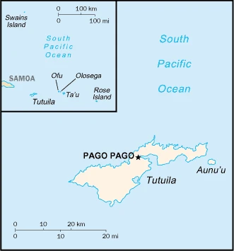
This state is located in Oceania, a group of islands in the South Pacific Ocean, about halfway between Hawaii and New Zealand, under the coordinates of 14 20 S, 170 00 W, covering an area of 224 sq km with a coastline of 116 km. American Samoa is Slightly larger than Washington, DC.
American Samoa has 0 km of land boundaries in total and borders with none.
Five volcanic islands with rugged peaks and limited coastal plains, two coral atolls (rose atoll, swains island), with Lata mountain 964 m as the highest point of American Samoa, while Pacific Ocean 0 m as the lowest point. With a total of 224 sq km, American Samoa has 224 sq km of land and 0 sq km water surface area.
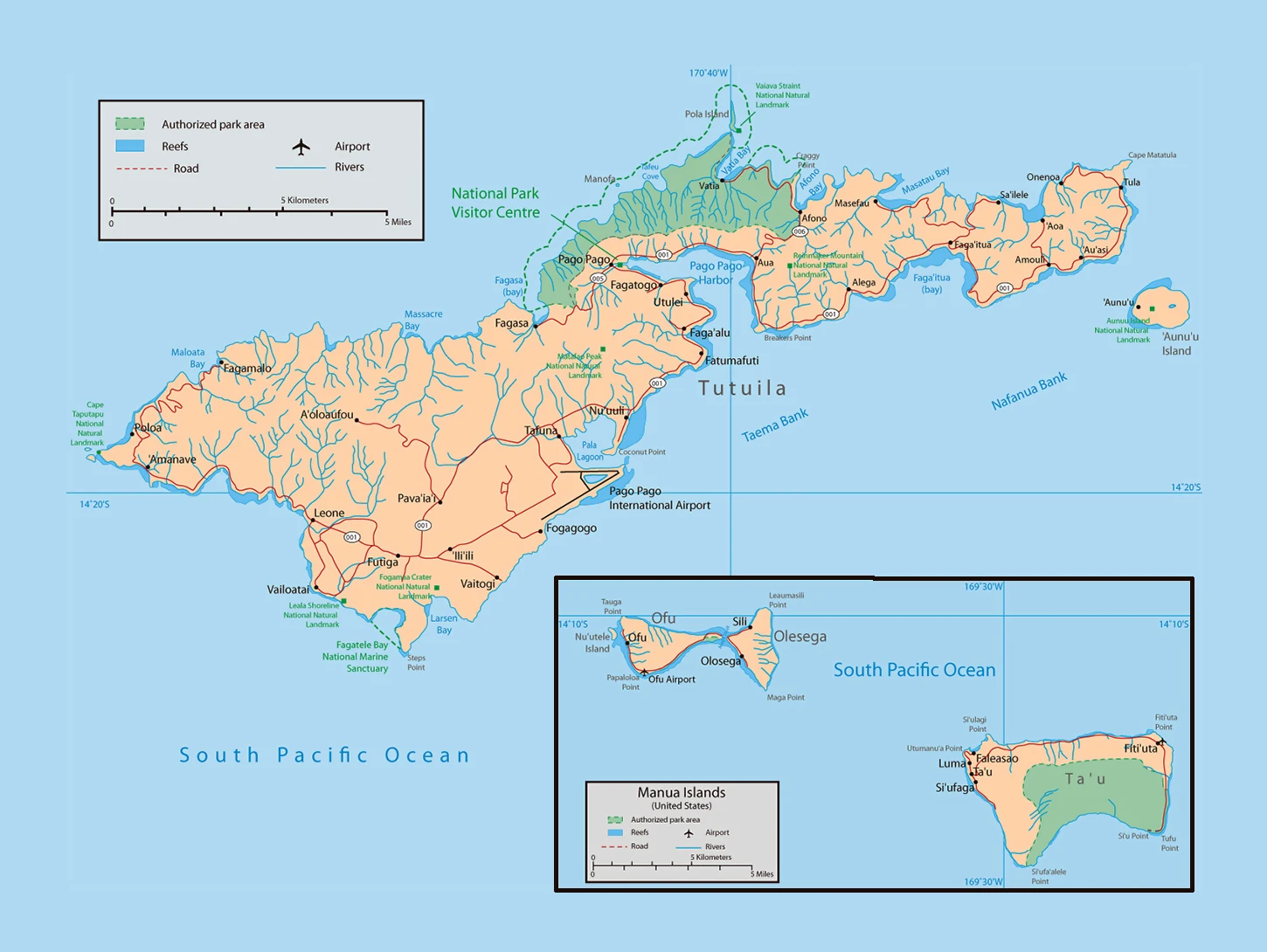
Pago Pago has one of the best natural deepwater harbors in the South Pacific Ocean, sheltered by shape from rough seas and protected by peripheral mountains from high winds; strategic location in the South Pacific Ocean.
The climate in American Samoa is as follows: Tropical marine, moderated by southeast trade winds, annual rainfall averages about 3 m, rainy season (November to April), dry season (May to October), slight seasonal temperature variation. However, rain follows clouds blown in by the trade winds that rise from the east almost daily throughout the year. The mountains of the Pago Pago area, standing protectively over Pago Pago Harbor, catch these clouds, bringing an average of 200 inches or 5,100 millimeters of rainfall per year.
When you visit American Samoa, the natural hazards shall be considered: Cyclones common from December to march volcanism: limited volcanic activity on the Ofu and Olosega islands; neither has erupted since the 19th century.
The following major health-threatening issues shall be considered when visiting American Samoa: none.
Current environmental issues affecting the American Samoan people: limited supply of drinking water; pollution; waste disposal; coastal and stream alteration; soil erosion.
Google Maps American Samoa
The capital and other divisions
Capital city: Pago Pago found under the coordinates 14 16 S, 170 42 W, applying the time zone UTC-11 (6 hours behind Washington, DC, during Standard Time), using the following daylight saving time: none. Pago Pago is a village in the South Pacific Ocean, an island of Samoa. The population of Pago Pago is currently around 12,000 people.
With the only urban area in America Samoa, Pago Pago serves as the main port of America Samoa. The Greater Pago Pago Metropolitan Area encompasses several villages, including Nafiji Landing, Western Tour Village, and Heritage Mountain.
American Samoa became independent on none (territory of the U.S.), and its national holiday is Flag Day, 17 April (1900).
Administrative divisions: none (territory of the U.S.); the U.S. Government defines no first-order administrative divisions, but there are 3 districts and 2 islands at the second order; Eastern, Manua, Rose Island, Swains Island, Western.
People and society
The population in American Samoa is 46,366 (July 2021 estimate), with an average of -2.1% (2021 estimate) change. That means American Samoa is the No. 210 in the world’s populated rank list. With an average of 27.2 years median age (26.7 years for males and 26.7 years for women), American Samoa ranks No. 149 on the globe’s median age rank list.
The people living in this country are the American Samoan(s), (U.S. nationals) (noun) or American Samoan (adjective) and belong mainly to the following ethnic groups: Pacific Islander 92.6% (includes Samoan 88.9%, Tongan 2.9%, other .8%), Asian 3.6% (includes Filipino 2.2%, other 1.4%), mixed 2.7%, other 1.2% (2010 estimate). Note: data represent population by ethnic origin or race.
They speak Samoan 88.6% (closely related to Hawaiian and other Polynesian languages), English 3.9%, Tongan 2.7%, other Pacific islanders 3%, other 1.8% (2010 estimate). Note: most people are bilingual languages and practice the following religions: Christian 98.3%, other <1%, unaffiliated <1% (2020 estimate). We can conclude the following about the population in American Samoa: about 87.2% (2021) of the total population is living in cities, and most of them reside in the following municipalities: 49,000 Pago Pago (capital city) (2018).
Industry
Although it faces economic setbacks, American Samoa also boasts its resilience. The island’s canning industry provides additional revenue for the territorial government. Due to inconsistent airline services, insufficient high-quality accommodations, and a lack of tourism knowledge on the island, efforts have been delayed in generating a tourist-driven economy similar to some other U.S. territories.
American Samoa s a traditional Polynesian economy in which more than 90% of the land is communally owned. Economic activity is strongly linked to the U.S., with which American Samoa conducts most of its commerce. Tuna fishing and processing are the backbones of the private sector, with processed fish products as the primary exports. The fish processing business accounted for 15.5% of employment in 2015. In late September 2009, an earthquake and the resulting tsunami devastated American Samoa and nearby Samoa, disrupting transportation and power generation, and resulting in about 200 deaths. The U.S. Federal Emergency Management Agency oversaw a relief program of nearly $25 million. Transfers from the U.S. Government add substantially to American Samoas economic well-being. Attempts by the government to develop a more extensive economy are restrained by Samoa’s remote location, its limited transportation, and its devastating hurricanes. Tourism has some potential as a source of income and jobs.
American Samoa is rich in the following natural resources: Pumice pumicite.
The main industrial sectors are typically tuna canneries (largely supplied by foreign fishing vessels) handicrafts.
The country’s export sectors are particularly strong in canned tuna, partnering with these nations: Australia 25%, Ghana 19%, Indonesia 15.6%, Burma 10.4%, Portugal 5.1% (2017). The export trade resulted in $428 million. Note: Data are in current year dollars (2016 estimate). In a global rank of the export, values resulted in American Samoa’s position of 193.
Land use in American Samoa: 75.5% (2018 estimate) forest, 0% (2018 estimate) other.
The arable land area is 15% (2018 estimate), and the agricultural land is 24.5% (2018 estimate). Land use for permanent crops 9.5% (2018 estimate), permanent pasture 0% (2018 estimate). The sum of the area of the irrigated land is 0 sq km (2012).
The main agro-industrial products of American Samoa are bananas, coconuts, vegetables, taro, breadfruit, yams, copra, pineapples, papayas, dairy products, livestock.
The country typically needs to import: raw materials for canneries, food, petroleum products, machinery, and parts, partnering with the following nations: Fiji 10.7%, Singapore 10.4%, NZ 10.4%, South Korea 9.3%, Samoa 8.2%, Kenya 6.4%, Australia 5.2% (2017) in a sum value of $615 million (2016 estimate) $657 million (2015 estimate). This sum value on the global ranking list of imports resulted in American Samoa 199.
American Samoa Driving Directions
In this post, you learned about American Samoa, Oceania, a group of islands in the South Pacific Ocean, about halfway between Hawaii and New Zealand. We published some basic information about its capital Pago Pago, and the American Samoan nation.
Are you interested in visiting American Samoa and looking for driving directions? Click here to plan your route, or see a printable road map of American Samoa below for an overview of the route network.
Printable map of American Samoa
Did you know about American Samoa?
Many people don’t know about American Samoa, but it’s one of the most incredible places on earth. It is composed of five different islands. The climate is tropical, with a warm temperature year-round. There are pristine beaches and crystal clear water for snorkeling. The culture is also fascinating because it’s considered one of the last areas in the world with an indigenous population.
After virtually visiting American Samoa, you may also be interested in the neighboring countries: Samoa, Tokelau, Wallis and Futuna.
If you liked our Google map and American Samoa information page,
please share it with others or save the link https://www.drivingdirections.net in your bookmarks.