
Aruba Google Maps is a site/tool that offers a wide range of map views (topographic, satellite, street view) and navigation options, with little effort on your part, yet efficiently. If you need to plan a trip to a new place like Aruba, Google maps are available on desktop, mobile, or tablet. This Google maps and information page is dedicated to Aruba, Central America, and the Caribbean (35 countries), showing its location, country facts, details about its capital city Oranjestad, bordering countries like none, and plenty of other information which may be interesting when you visit this Central American and the Caribbean state.
Quick links: Google Maps Aruba, Oranjestad Google maps, Driving Directions Aruba, Printable Road Map.
About Aruba in a nutshell
- Conventional short form of the name: Aruba
- The conventional long form of the name: Country of Aruba
- Local long form: Land Aruba (Dutch); Pais Aruba (Papiamento)
- Local short form: Aruba
- Former name(s): N/A
- Etymology: the origin of the islands name is unclear; according to tradition, the name comes from the Spanish phrase oro huba (there was gold), but in fact no gold was ever found on the island; another possibility is the native word oruba, which means well-situated.
- The legal system in Aruba: civil law system based on the Dutch civil code.
- Climate: Tropical marine, slight seasonal temperature variation.
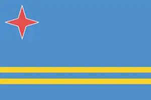
- The national symbols are Hooiberg (Haystack) Hill; national colors: blue, yellow, red, white.
- Internet TLD: .aw
Background
Discovered and claimed for Spain in 1499, Aruba was acquired by the Dutch in 1636. Three primary industries have dominated the island’s economy. A 19th-century gold rush was followed by prosperity brought on by the opening in 1924 of an oil refinery. The last decades of the 20th century saw a boom in the tourism industry. Aruba seceded from the Netherlands Antilles in 1986 and became a separate, semi-autonomous member of the Kingdom of the Netherlands. The movement toward complete independence was halted at Aruba’s request in 1990.
Geography
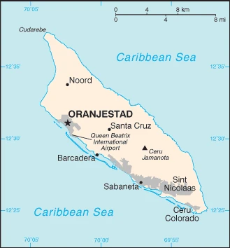
Aruba is a small island located on the American continent in the Caribbean Sea. It is often called the “Emerald Isle of the Caribbean” because of its tropical beauty and warm climate.
This state is located in the Caribbean, an island in the Caribbean Sea, north of Venezuela, under the coordinates of 12 30 N, 69 58 W, covering an area of 180 sq km with a coastline of 68.5 km. Aruba is Slightly larger than Washington, DC.
Flat with a few hills, scant vegetation, with Ceru Jamanota 188 m as the highest point of Aruba, while the Caribbean Sea 0 m as the lowest point, causing a mean elevation at N/A throughout the country. With a total of 180 sq km, Aruba has 180 sq km of land and 0 sq km water surface area.
It is a flat, riverless island renowned for its white-sand beaches; its tropical climate is moderated by constant trade winds from the Atlantic Ocean; it is almost constant at about 27 degrees Celsius (81 degrees Fahrenheit).
The climate in Aruba is as follows: Tropical marine, slight seasonal temperature variation.
When you visit Aruba, the natural hazards shall be considered: Hurricanes lie outside the Caribbean hurricane belt and are rarely threatened.
The following major health-threatening issues shall be considered when visiting Aruba: none.
Current environmental issues affecting the Aruban; Dutch people: difficulty in properly disposing of waste produced by large numbers of tourists; waste burning in the landfill causes air pollution and poses an environmental and health risk; ocean environmental damage due to plastic pollution.
Google Maps Aruba
The capital and other divisions
Capital city: Oranjestad found under the coordinates 12 31 N, 70 02 W, applying the time zone UTC-4 (1 hour ahead of Washington, DC, during Standard Time), using the following daylight saving time: none.
Oranjestad is the capital city of Aruba. With more than 18,000 inhabitants, the city is the country’s main economic and commercial center.
Aruba became independent on none (part of the Kingdom of the Netherlands), and its national holiday is National Anthem and Flag Day, 18 March (1976).
Administrative divisions: none (part of the Kingdom of the Netherlands) note: Aruba is one of four constituent countries of the Kingdom of the Netherlands; the other three are the Netherlands, Curacao, and Sint Maarten.
People and society
The population in Aruba is 120,917 (July 2021 estimate), with an average of 1.17% (2021 estimate) change. That means Aruba is the No. 188 in the world’s populated rank list. With an average of 39.9 years median age (38.2 years for males and 38.2 years for women), Aruba ranks No. 53 on the globe’s median age rank list.
The people living in this country are the Aruban(s) (noun) or Aruban; Dutch (adjective) and belong mainly to the following ethnic groups: Aruban 66%, Colombian 9.1%, Dutch 4.3%, Dominican 4.1%, Venezuelan 3.2%, Curacaoan 2.2%, Haitian 1.5%, Surinamese 1.2%, Peruvian 1.1%, Chinese 1.1%, other 6.2% (2010 estimate). Note: data represent population by country of birth.
They speak Papiamento (official language) (a creole language that is a mixture of Portuguese, Spanish, Dutch, English, and, to a lesser extent, French, as well as elements of African languages and the language of the Arawak) 69.4%, Spanish 13.7%, English (widely spoken) 7.1%, Dutch (official language) 6.1%, Chinese 1.5%, other 1.7%, unspecified 0.4% (2010 estimate) languages and practice the following religions: Roman Catholic 75.3%, Protestant 4.9% (includes Methodist 0.9%, Adventist 0.9%, Anglican 0.4%, other Protestant 2.7%), Jehovahs Witness 1.7%, other 12%, none 5.5%, unspecified 0.5% (2010 estimate).
We can conclude the following about the population in Aruba: Most residents live in or around Oranjestad and San Nicolaas. Most settlements tend to be located on the less mountainous western side of the island. In Aruba, we are talking about 43.9% (2021) of the total population is living in cities, and most of them reside in the following municipalities: 30,000 Oranjestad (capital city) (2018).
Industry
Tourism, petroleum bunkering, hospitality, and financial and business services are the mainstays of the small open Aruban economy. Tourism accounts for most economic activity; as of 2017, over 2 million tourists visited Aruba annually, with the large majority (80-85%) of those from the US. The rapid growth of the tourism sector has resulted in a substantial expansion of other activities. Construction continues to boom, especially in the hospitality sector. Aruba is heavily dependent on imports and is expanding exports to improve its trade balance. Almost all consumer and capital goods are imported, with the US, the Netherlands, and Panama being the major suppliers. In 2016, Citgo Petroleum Corporation, an indirect wholly-owned subsidiary of Petroleos de Venezuela SA, and the Government of Aruba signed an agreement to restart Valero Energy Corp.s former 235,000-b/d refinery. Tourism and related industries have continued to grow, and the Aruban Government is working to attract more diverse industries. Aruba’s banking sector continues to be strong; unemployment has significantly decreased.
Aruba is rich in natural resources: White sandy beaches foster tourism.
The main industrial sectors are typically tourism, petroleum transshipment facilities, banking.
The country’s export sectors are particularly strong in refined petroleum, liquors, scrap iron, soap, tobacco (2019), partnering with these nations: Malaysia 57%, United States 11%, Netherlands 6%, Jordan 6%, Venezuela 5% (2019). The export trade resulted in $1.45 billion. Note: Data are in current year dollars (2020 estimate). In a global rank of the export, values resulted in Aruba’s position of 166.
Land use in Aruba: 2.3% (2018 estimate) forest, 86.6% (2018 estimate) other.
The arable land area is 11.1% (2018 estimate), and the agricultural land is 11.1% (2018 estimate). Land use for permanent crops 0% (2018 estimate), permanent pasture 0% (2018 estimate). The sum of the area of the irrigated land is N/A.
The main agro-industrial products of Aruba are aloes, livestock, fish.
The country typically needs to import: refined petroleum, jewelry, cars, vehicle parts, tobacco products (2019), partnering with the following nations: the United States 48%, Netherlands 16% (2019) in a sum value of $1.67 billion. Note: data are in current year dollars (2020 estimate) $2.24 billion. Note: data are in current year dollars (2019 estimate) $2.27 billion. Note: data are in current year dollars (2018 estimate). This sum value on the global ranking list of imports resulted in Aruba 179.
Aruba Driving Directions
In this post, you learned about Aruba, the Caribbean, an island in the Caribbean Sea, north of Venezuela. We published some basic information about its capital Oranjestad, and the Aruban, Dutch nation.
Are you interested in visiting Aruba and looking for driving directions? Click here to plan your route, or see a printable road map of Aruba below for an overview of the route network.
Printable map of Aruba

Did you know about Aruba?
Aruba is a Dutch island in the Caribbean. It’s the third-largest island of the ABC islands of the Netherlands Antilles after Bonaire and Curaçao. Aruba has many famous natural attractions, including beaches, caves, and natural parks.
After virtually visiting Aruba, you may also be interested in the neighboring countries: none.
If you liked our Google map and Aruba information page,
please share it with others or save the link https://www.drivingdirections.net in your bookmarks.