
Ashmore and Cartier Islands Google Maps is a site/tool that offers a wide range of map views (topographic, satellite, street view) and navigation options, with little effort on your part, yet efficiently. If you need to plan a trip to a new place like Ashmore and Cartier Islands, Google maps are available on desktop, mobile, or tablet. This Google maps and information page is dedicated to Ashmore and Cartier Islands, Southeast Asia (19 countries), showing its location, country facts, details about its capital city N/A, bordering countries like none, and plenty of other information which may be interesting when you visit this Southeastern Asian state.
Quick links: Google Maps Ashmore and Cartier Islands, N/A Google maps, Driving Directions Ashmore and Cartier Islands, Printable Road Map.
About Ashmore and Cartier Islands in a nutshell
- Conventional short form of the name: Ashmore and Cartier Islands
- The conventional long form of the name: Territory of Ashmore and Cartier Islands
- Etymology: named after British Captain Samuel ASHMORE, who first sighted his namesake island in 1811, and after the ship Cartier, from which the second island was discovered in 1800.
- The legal system in Ashmore and Cartier Islands: the laws of the Commonwealth of Australia and the laws of the Northern Territory of Australia, where applicable, apply.
- Climate: Tropical.
Background
Indonesian fishers have long fished in the Ashmore Reef and Cartier Island area. British explorers were the first Europeans to see Cartier Island and Ashmore Reef in 1800 and 1811. American whalers frequently sailed by the islands in the 1850s and later settled to mine the phosphate deposits on Ashmore Reef, exhausted by 1891. The UK disputed the US access to Ashmore Reef and formally annexed it in 1878. Cartier Island was annexed in 1909. In 1931, the UK transferred the islands to Australia, which accepted them in 1934 as part of Western Australia.
In 1938, Australia transferred governance to the Northern Territory. The islands saw several Allied ship visits during World War II, and Cartier Island became a bombing range post-war. In 1978, the governance of Ashmore and Cartier Islands was moved to the federal government. Ashmore Reef and Cartier Island became marine reserves in 1983 and 2000, respectively. In 1974, Australia and Indonesia signed a memorandum of understanding (MOU) to allow Indonesian fishers to continue fishing around the islands. The MOU also allows Indonesian fishers to visit the graves of past fishers, replenish their fresh water, and shelter in the West Island Lagoon of Ashmore Reef. In the 1990s, Indonesia challenged Australias claims to the islands, which was settled in a maritime boundary treaty in 1997. The islands were a popular first point of contact for migrants and refugees seeking to enter Australia, so in 2001, Australia declared the islands outside the Australian migration zone.
Geography
Ashmore and Cartier Islands are two tiny, isolated dots in the Indian Ocean about halfway between Australia and Antarctica.
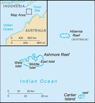
This state is located in Southeastern Asia, islands in the Indian Ocean, midway between northwestern Australia and Timor island. Ashmore Reef is 840 km west of Darwin and 610 km north of Broome. Cartier Islet is 70 km east of Ashmore Reef, under the coordinates of 12 25 S, 123 20 E, covering an area of 5 sq km with a coastline of 74.1 km. Ashmore and Cartier Islands is About eight times the size of the national mall in Washington, DC.
Low with sand and coral, Cartier island 5 m as the highest point of Ashmore and Cartier Islands, while Indian Ocean 0 m as the lowest point, causing a mean elevation at N/A throughout the country. With a total of 5 sq km, Ashmore and Cartier Islands has 5 sq km of land and 0 sq km water surface area.
Ashmore Reef National Nature Reserve was established in August 1983; Cartier Island Marine Reserve was established in 2000.
The climate in Ashmore and Cartier Islands is as follows: Tropical.
When you visit Ashmore and Cartier Islands, the natural hazards shall be considered: Surrounded by shoals and reefs that can pose maritime hazards.
The following major health-threatening issues shall be considered when visiting Ashmore and Cartier Islands: none.
Current environmental issues affecting the people: the illegal killing of protected wildlife by traditional Indonesian anglers, as well as fishing by non-traditional Indonesian vessels, are ongoing problems; sea-level rise, changes in sea temperature, and ocean acidification are concerns; marine debris.
Google Maps Ashmore and Cartier Islands
The capital and other divisions
One of the most southern islands in Australia, Ashmore Island is just 45 miles away from the closest point in the continent. This remote island is home to various native flora and fauna and several unusual birds, such as the Cartier petrel and Kermode bear.
People and society
Ashmore and Cartier Islands population has no indigenous inhabitants (July 2021 estimate). Note: Indonesian fishers are allowed access to the lagoon and fresh water at Ashmore Reefs West Island; access to East and Middle Islands is by permit only, with an average of 0.32% (2021 estimate) change.
Industry
No economic activity.
Ashmore and Cartier Islands are rich in the following natural resources: Fish.
Ashmore and Cartier Islands Driving Directions
In this post, you learned about Ashmore and Cartier Islands, Southeastern Asia, islands in the Indian Ocean, midway between northwestern Australia and Timor island. Ashmore Reef is 840 km west of Darwin and 610 km north of Broome. Cartier Islet is 70 km east of Ashmore Reef.
Are you interested in visiting Ashmore and Cartier Islands and looking for driving directions? Click here to plan your route, or see a printable road map of Ashmore and Cartier Islands below for an overview of the route network.
Printable map of Ashmore and Cartier Islands

Did you know about Ashmore and Cartier Islands?
Ashmore and Cartier Islands are two uninhabited Australian islands in the Indian Ocean. India is currently occupying the island, but the land has been leased to Australia for 50 years. It was initially used as a naval base until it became an Indian territory in 1983.
After virtually visiting Ashmore and Cartier Islands, you may also be interested in the neighboring countries: none.
If you liked our Google map and Ashmore and Cartier Islands information page,
please share it with others or save the link https://www.drivingdirections.net in your bookmarks.