
Antarctica Google Maps is a site/tool that offers a wide range of map views (topographic, satellite, street view) and navigation options, with little effort on your part, yet efficiently. If you need to plan a trip to a new place like Antarctica, Google maps are available on desktop, mobile, or tablet. This Google maps and information page is dedicated to Antarctica, Antarctic Region (4 countries), showing its location, country facts, details about it, and plenty of other information which may be interesting when you visit this Antarctic region.
Quick links: Google Maps Antarctica, Antarctica Google maps, Driving Directions Antarctica, Printable Road Map.

About Antarctica in a nutshell
- Conventional short form of the name: Antarctica
- The conventional long form of the name: none
- Etymology: name derived from two Greek words meaning opposite to the Arctic or opposite to the north.
- The legal system in Antarctica: Antarctica is administered through annual meetings – known as Antarctic Treaty Consultative Meetings – which include consultative member nations, non-consultative member nations, observer organizations, and expert organizations; decisions from these meetings are carried out by these member nations (with respect to their own nationals and operations) in accordance with their own national laws; more generally, the Antarctic Treaty area, that is to all areas between 60 and 90 degrees south latitude, is subject to a number of relevant legal instruments and procedures adopted by the states party to the Antarctic Treaty;.
- Climate: The coldest, windiest, and driest continent on Earth.
- Internet TLD: .aq
The highest point in the Antarctic is the Vinson Massif, which rises 4,897 meters from the 5,000-kilometer-long Transantarctic Mountains. Antarctica has the deepest non-water depression on Earth, with the ice-covered Bentley Trench sinking to 2,555 meters below sea level. There is no permanent water flow on the continent. Unlike its northern counterpart, Antarctica has no indigenous inhabitants.
Until the mid-19th century, the ice kingdom was thought to be just a vast archipelago. Amundsen of Norway first flew his country’s flag at the pole in 1911. Under the Antarctic Treaty, first signed in 1959 and which came into force in January 1961, the entire Antarctic is an internationally neutral area, with no economic or military activity, only scientific research, allowed on the continent.
Today, 26 nations operate 38 permanent and 34 temporary research stations in the area, hosting some 4,000 researchers each year, and a further 1,000 researchers and cruise crews cruise Antarctic waters in summer. The Antarctic coast is visited by an average of 12-13,000 tourists a year: the icebreakers, mostly Russian-built and crewed, are operated by American travel agencies and now also offer extreme tourism programs to the pole.
Background
Speculation over the existence of a southern land was not confirmed until the early 1820s when British and American commercial operators and British and Russian national expeditions began exploring the Antarctic Peninsula region and other areas south of the Antarctic Circle. Not until 1840 was it established that Antarctica was indeed a continent and not merely a group of islands or an area of ocean. Several exploration firsts were achieved in the early 20th century, but generally, the area saw little human activity. However, following World War II, the continent experienced an upsurge in scientific research.
Several countries have set up year-round and seasonal stations, camps, and refuges to support scientific research in Antarctica. Seven have made territorial claims, but most countries do not recognize these claims. To form a legal framework for the activities of nations on the continent, an Antarctic Treaty was negotiated that neither denies nor recognizes existing territorial claims. Signed in 1959, it entered into force in 1961. Also relevant to Antarctic governance are the Environmental Protocol to the Antarctic Treaty and the Convention for the Conservation of Antarctic Marine Living Resources.
Geography
Antarctica is the most enormous landmass on Earth. It is a continent that has been relatively untouched by human civilization and is remote from the rest of the world. However, with recently increased exploration, it is possible that Antarctica could become home to hundreds and thousands of people shortly.
This state is located in a continent mostly south of the Antarctic Circle, under the coordinates of 90 00 S, 0 00 E, covering an area of 14.2 million sq km with a coastline of 17,968 km. Antarctica is Slightly less than 1.5 times the size of the US.
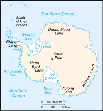
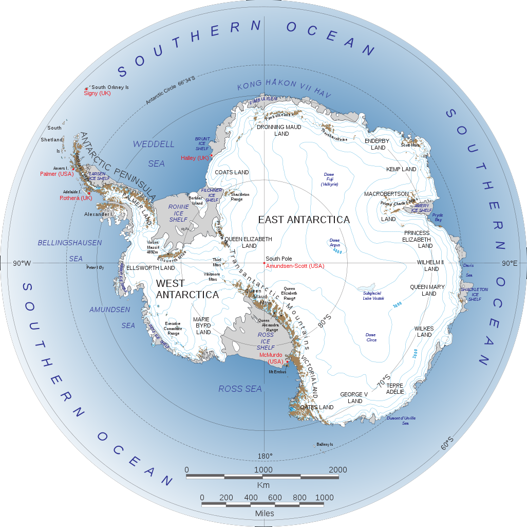
About 98% thick continental ice sheet and 2% barren rock, with average elevations between 2,000 and 4,000 m, mountain ranges up to nearly 5,000 m. Ice-free coastal areas include parts of southern victoria land, Wilkes land, the antarctic peninsula area, and parts of ross island on McMurdo sound, glaciers form ice shelves along with about half of the coastline, and floating ice shelves constitute 11% of the area of the continent, with Vinson massif 4,892 m as the highest point of Antarctica, while Denman Glacier more than -3,500 m (-11,500 ft) below sea level as the lowest point, causing a mean elevation at 2,300 m throughout the country. With a total of 14.2 million sq km, Antarctica has 14.2 million sq km (285,000 sq km ice-free, 13.915 million sq km ice-covered) of land and N/A water surface area.
The coldest, windiest, highest (on average), and driest continent; during summer, more solar radiation reaches the surface at the South Pole than is received at the Equator in an equivalent period mostly uninhabitable, 98% of the land area is covered by the Antarctic ice sheet, an enormous single mass of ice on Earth covering an area of 14 million sq km (5.4 million sq mi) and containing 26.5 million cu km (6.4 million cu mi) of ice (this is almost 62% of all of the worlds freshwater); if all this ice were converted to liquid water, one estimate is that it would be sufficient to raise the height of the world’s oceans by 58 m (190 ft).
The climate in Antarctica is as follows: The coldest, windiest, and driest continent on Earth, severe low temperatures vary with latitude, elevation, and distance from the ocean, east Antarctica is colder than West Antarctica because of its higher elevation, the antarctic peninsula has the most moderate climate, higher temperatures occur in January along the coast and average slightly below freezing, summers characterized by continuous daylight, while winters bring continuous darkness, persistent high pressure over the interior brings dry, subsiding air that results in minimal cloud cover.
When you visit Antarctica, the natural hazards shall be considered: Katabatic (gravity-driven) winds blow coastward from the high interior; frequent blizzards form near the foot of the plateau; cyclonic storms form over the ocean and move clockwise along the coast; volcanism on deception island and isolated areas of West Antarctica; other seismic activity rare and weak; large icebergs may calve from the ice shelf.
The following major health-threatening issues shall be considered when visiting Antarctica: none.
Current environmental issues affecting the people in Antarctica: the discovery of a large Antarctic ozone hole in the Earth’s stratosphere (the ozone layer) – first announced in 1985 – spurred the signing of the Montreal Protocol in 1987, an international agreement phasing out the use of ozone-depleting chemicals; the ozone layer prevents most harmful wavelengths of ultra-violet (UV) light from passing through the Earth’s atmosphere; ozone depletion has been shown to harm a variety of Antarctic marine plants and animals (plankton); in 2016, a gradual trend toward the healing of the ozone hole was reported; since the 1990s, satellites have shown accelerating ice loss driven by ocean change; although considerable uncertainty remains, scientists are increasing our understanding and ability to model potential impacts of ice loss.
Google Maps Antarctica
Antarctica is the fifth-largest continent on Earth, encompassing almost 14 million square kilometers or 5.4 million square miles of land area. It is the coldest continent on Earth, with an average temperature of -56 degrees Celsius (or -67 degrees Fahrenheit). This makes Antarctica one of the driest places on Earth. Antarctica was discovered in 1820 and was often considered a myth until it existed.
People and society
The population in Antarctica is no indigenous inhabitants, but there are both permanent and summer-only staffed research stations. Note: 53 countries have signed the 1959 Antarctic Treaty; 30 of those operate through their National Antarctic Program a number of seasonal-only (summer) and year-round research stations on the continent and its nearby islands south of 60 degrees south latitude (the region covered by the Antarctic Treaty); the population engaging in and supporting science or managing and protecting the Antarctic region varies from approximately 4,400 in summer to 1,100 in winter; in addition, approximately 1,000 personnel, including ships crew and scientists doing onboard research, are present in the waters of the treaty region, as of 2017, peak summer (December-February) maximum capacity in scientific stations – 4,877 total; Argentina 601, Australia 243, Belarus 12, Belgium 40, Brazil 66, Bulgaria 22, Chile 433, China 166, Czechia 20, Ecuador 34, Finland 17, France 90, France and Italy jointly 80, Germany 104, India 113, Italy 120, Japan 130, South Korea 130, Netherlands 10, NZ 86, Norway 70, Peru 30, Poland 40, Russia 335, South Africa 80, Spain 98, Sweden 20, Ukraine 24, UK 196, US 1,399, Uruguay 68 (2017) winter (June-August) maximum capacity in scientific station – 1,036 total; Argentina 221, Australia 52, Brazil 15, Chile 114, China 32, France 24, France and Italy jointly 13, Germany 9, India 48, Japan 40, Netherlands 10, South Korea 25, NZ 11, Norway 7, Poland 16, Russia 125, South Africa 15, Ukraine 12, UK 44, US 215, Uruguay 8 (2017) research stations operated within the Antarctic Treaty area (south of 60 degrees south latitude) by National Antarctic Programs year-round stations – approximately 40 total; Argentina 6, Australia 3, Brazil 1, Chile 6, China 2, France 1, France and Italy jointly 1, Germany 1, India 2, Japan 1, Netherlands 1, South Korea 2, NZ 1, Norway 1, Poland 1, Russia 5, South Africa 1, Ukraine 1, UK 2, US 3, Uruguay 2 (2017) a range of seasonal-only (summer) stations, camps, and refuges – Argentina, Australia, Belarus, Belgium, Bulgaria, Brazil, Chile, China, Czechia, Ecuador, Finland, France, Germany, India, Italy, Japan, Netherlands, South Korea, New Zealand, Norway, Peru, Poland, Russia, South Africa, Spain, Sweden, Ukraine, UK, US, and Uruguay (2017) in addition, during the austral summer some nations have numerous occupied locations such as tent camps, summer-long temporary facilities, and mobile traverses in support of research.
Industry
Scientific undertakings rather than commercial pursuits are the predominant human activity in Antarctica. Offshore fishing and tourism, both based abroad, account for Antarctica’s limited economic activity. Within the area covered by the Convention on Conservation of Antarctic Marine Living Resources, Antarctic Fisheries currently target Patagonian toothfish, Antarctic toothfish, mackerel icefish, and Antarctic krill. The Commission for the Conservation of Antarctic Marine Living Resources (CCAMLR) manages these fisheries using the ecosystem-based and precautionary approach. The commission’s objective is to conserve Antarctic marine living resources, and it regulates the fisheries based on the level of information available and maintains existing ecological relationships.
While Illegal, Unreported, and Unregulated (IUU) fishing has declined in the Convention area since 1990, it remains a concern. A total of 51,707 tourists visited the Antarctic Treaty area in the 2017-2018 Antarctic summer, 17 percent greater than the 43,915 visitors in 2016-2017. The International Association of Antarctica Tour Operators provided these estimates to the Antarctic Treaty and did not include passengers on overflights. Nearly all tourists were passengers on commercial ships and several yachts that make trips during the summer.
Antarctica is rich in the following natural resources: Iron ore, chromium, copper, gold, nickel, platinum, and other minerals, and coal and hydrocarbons have been found in small noncommercial quantities. Mineral exploitation, except for scientific research, is banned by the environmental protocol of the antarctic treaty: krill, icefish, toothfish, and crab have been taken by commercial fisheries, which are managed through the commission for the conservation of antarctic living marine resources.
Antarctica Driving Directions
Are you interested in visiting Antarctica and looking for driving directions? Click here to plan your route, or see a printable road map of Antarctica below for an overview of the route network.
Printable map of Antarctica
Did you know about Antarctica?
The continent of Antarctica is the coldest, windiest, highest, and driest continent on Earth. It has the world’s most giant ice sheet, and about 60% of all fresh water on Earth is held as ice there. The average temperature in the summer (December through February) is between minus 10°C (14°F) and minus 30°C (86°F), while in the winter it is much colder, usually between minus 40°C (minus 40°F) and minus 85°C (minus 113°F).
The flag of Antarctica
Antarctica does not belong to any country, nor is it a separate state, so it has no official flag. Yet there are several ideas of what should adorn a South Pole flag.
Currently, there is only one flag officially associated with Antarctica. In 2002, the negotiating members of the Antarctic Treaty, which came into force in 1961 and gave the continent its status, adopted a pendant and a flag, but this is not a symbol of the continent, only of the Antarctic Treaty. There is, however, an alternative proposal made by British professional vexillologist Graham Bartram.
His version would be based on the United Nations flag, with the same light blue base and white to represent the southern continent. This flag has been quasi-officially flown on the flagpoles of research stations in Antarctica in Brazil, Ukraine, and the UK.
Countries use their national flags on their research stations, of course, but a New Zealand vexillologist, for example, is promoting his flag for the Ross Antarctic Territory. The country still has a living territorial claim to the Ross Sea and ice shelf sector and, as such, deserves its flag based on the New Zealand flag. Argentina, Australia, Chile, the UK, France, and Norway also have territorial claims in the southern continent. The US and Russia are also claiming rights to make such a claim later. However, it is unlikely that any of them will tear up the Antarctic Treaty shortly, enforcing them by force and flying their Antarctic flag on their newly occupied land.
After virtually visiting Antarctica, you may also be interested in the neighboring countries: Argentina, Chile, South Africa, New Zealand.
If you liked our Google map and Antarctica information page,
please share it with others or save the link https://www.drivingdirections.net in your bookmarks.