
Argentina Google Maps is a site/tool that offers a wide range of map views (topographic, satellite, street view) and navigation options, with little effort on your part, yet efficiently. If you need to plan a trip to a new place like Argentina, Google maps are available on desktop, mobile, or tablet. This Google maps and information page is dedicated to Argentina, South America (13 countries), showing its location, country facts, details about its capital city Buenos Aires, bordering countries like Bolivia, Brazil, Chile, Paraguay, Uruguay, and plenty of other information which may be interesting when you visit this South American state.
Quick links: Google Maps Argentina, Buenos Aires Google maps, Driving Directions Argentina, Printable Road Map.
About Argentina in a nutshell
- The Tango originated in the poorer quarters of Buenos Aires at the end of the 19th century.
- Conventional short form of the name: Argentina
- The conventional long form of the name: Argentine Republic
- Local long form: Republica Argentina
- Local short form: Argentina
- Former name(s): N/A
- Etymology: originally the area was referred to as Tierra Argentina, i.e., Land beside the Silvery River or silvery land, which referred to the massive estuary in the east of the country, the Rio de la Plata (River of Silver); over time the name shortened to simply Argentina or silvery.
- The legal system in Argentina: civil law system based on West European legal systems.
- Climate: The Andes are semiarid in the north and snowy in the south. Pampas have a mild with summer rains.
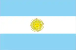
- The national symbols are Sun of May (a sun-with-face symbol); national colors: sky blue, white.
- Internet TLD: .ar
The almost entirely treeless, semi-desert Patagonia occupies a quarter of the vast country. It is the deepest point on the South American continent: the central depression of the Valdés Peninsula is 31 m below sea level. The continent’s highest point, Aconcagua, comprises sedimentary rocks rising to almost 7,000 meters, and a giant land ice sheet in the Southern Hemisphere outside Antarctica is in the South Andes. The southern section of the Ruta 3, or Pan-American Highway, ends near the southernmost city in the world, Ushuaia, at the Tierra del Fuego, or Tierra del Fuego National Park entrance. The glaciers of the Southern Andes feed the fjord lakes north of the Strait of Magellan.
The Los Glaciares National Park, home to the Perito Moreno glacier, which is still thriving today, the Iguazú Falls and its surroundings, and the wildlife of the Valdés Peninsula are World Natural Heritage sites, as are the 280 million-year-old fossils of the Isehigualasto and Talampaya connected nature reserves, dating back to the Triassic period of the earth’s history. The cave paintings found in the Cueva de Los Manos cave date back 13 000 years, and the Quebrada de Humahuaca valley was one of the main transport routes across the Andes for 10 000 years. The Jesuit monuments of Cordoba and the missionary ‘ruin cities’ of the Guaraní recall the heyday of the 17th and 18th centuries. The Falkland Islands, under British rule, are also claimed by Argentina.
Background
In 1816, the United Provinces of the Rio Plata declared their independence from Spain. After Bolivia, Paraguay, and Uruguay went their separate ways, the area that remained became Argentina. Immigrants from throughout Europe heavily shaped the country’s population and culture, with Italy and Spain providing the most significant percentage of newcomers from 1860 to 1930. Up until about the mid-20th century, much of Argentinas history was dominated by periods of internal political unrest and conflict between civilian and military factions. After World War II, an era of Peronist populism and direct and indirect military interference in subsequent governments was followed by a military junta that took power in 1976.
Democracy returned in 1983 after a failed bid to seize the Falkland Islands (Islas Malvinas) by force and has persisted despite numerous challenges, the most formidable of which was a severe economic crisis in 2001-02 that led to violent public protests and the successive resignations of several presidents. The years 2003-15 saw Peronist rule by Nestor and Cristina FERNANDEZ de KIRCHNER, whose policies isolated Argentina and caused economic stagnation. With the election of Mauricio MACRI in November 2015, Argentina began a period of reform and international reintegration.
Geography
The Andes form a natural border with Chile in the west. The heavily wooded plains (Gran Chaco) and treeless but fertile Pampas plains are East. Bleak and arid Patagonia lies in the south.
Argentina occupies most of southern South America. After 30 years of intermittent military rule, democracy returned in 1983. The economic crash in 2001 led to the largest-ever debt default.
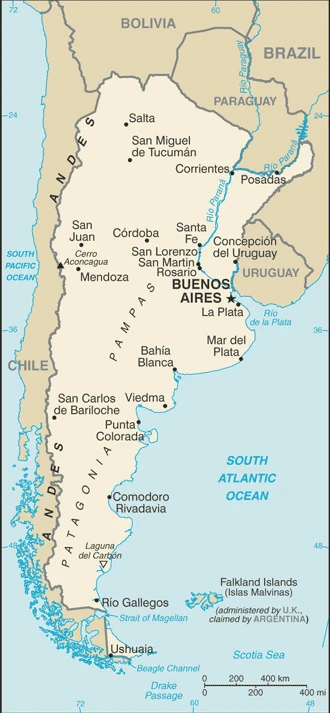
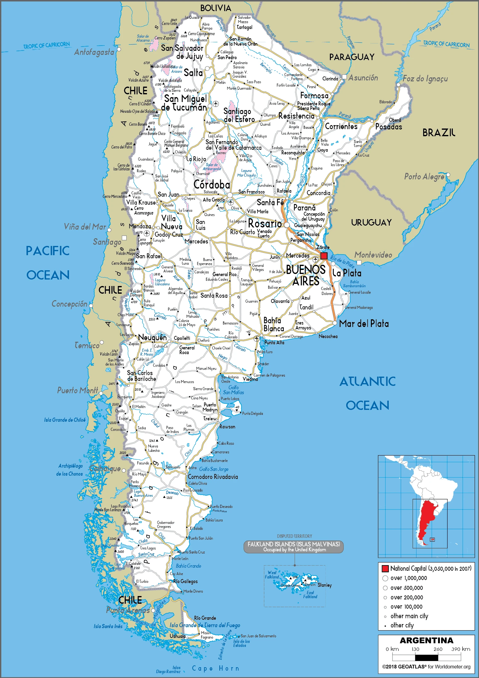
This state is located in Southern South America, bordering the South Atlantic Ocean, between Chile and Uruguay, under the coordinates of 34 00 S, 64 00 W, covering an area of 2,780,400 sq km with a coastline of 4,989 km. Argentina is slightly less than three-tenths the size of the US.
Argentina has 11,968 km of land boundaries in total, and bordering with (5 nations): Bolivia 942 km, Brazil 1263 km, Chile 6691 km, Paraguay 2531 km, Uruguay 541 km.
Rich plains of the pampas in the northern half, flat to rolling plateau of Patagonia in the south, rugged Andes along the western border, with Cerro Aconcagua (located in the northwestern corner of the province of Mendoza; the highest point in South America) 6,962 m as the highest point of Argentina, while Laguna del Carbon -105 m as the lowest point, causing a mean elevation at 595 m throughout the country. With a total of 2,780,400 sq km, Argentina has 2,736,690 sq km of land and 43,710 sq km water surface area.
Major water bodies in the country: Lago Buenos Aires (shared with Chile) – 2,240 sq km; Lago Argentino – 1,410 sq km; Lago Viedma – 1,090 sq km; Lago San Martin (shared with Chile) – 1,010 sq km; Lago Colhue Huapi – 800 sq km; Lago Fagnano (shared with Chile) – 590 sq km; Lago Nahuel Huapi – 550 sq km (freshwater lake), Laguna Mar Chiquita – 1,850 sq km; (saltwater lake) while the major rivers are: Rio de la Plata/Parana river mouth (shared with Brazil s, Paraguay, and Uruguay) – 4,880 km; Paraguay (shared with Brazil s, and Paraguay m) – 2,549 km; Uruguay (shared with Brazil s and Uruguay m) – 1,610 km. The significant watersheds for Argentina are Atlantic Ocean drainage: Paraná (2,582,704 sq km).
The second-largest country in South America (after Brazil); strategic location relative to sea lanes between the South Atlantic and the South Pacific Oceans (Strait of Magellan, Beagle Channel, Drake Passage); diverse geophysical landscapes range from tropical climates in the north to tundra in the far south; Cerro Aconcagua is the Western Hemispheres tallest mountain, while Laguna del Carbon is the lowest point in the Western Hemisphere; shares Iguazu Falls, the worlds most extensive waterfalls system, with Brazil.
The climate in Argentina is as follows: Mostly temperate, arid in the southeast, subantarctic in the southwest.
When you visit Argentina, the natural hazards shall be considered: San Miguel de Tucuman and Mendoza areas in the Andes subject to earthquakes; pamperos are violent windstorms that can strike the pampas and northeast; heavy flooding in some areas volcanism: volcanic activity in the Andes mountains along the Chilean border; opaque (2,997 m) last erupted in 2000; other historically active volcanoes include Llullaillaco, Maipo, Planchon-Peteroa, San Jose, Tromen, Tupungatito, and Viedma.
The following major health-threatening issues shall be considered when visiting Argentina: none.
Current environmental issues affecting the Argentine people: environmental problems (urban and rural) typical of an industrializing economy such as deforestation, soil degradation (erosion, salinization), desertification, air pollution, and water pollution.
Google Maps Argentina
The capital and other divisions
Capital city: Buenos Aires found under the coordinates 34 36 S, 58 22 W, applying the time zone UTC-3 (2 hours ahead of Washington, DC, during Standard Time), using the following daylight saving time: none.
Buenos Aires may not be the first place that comes to mind when thinking about travel destinations, but there are many reasons why it should be on your list of places to visit. With a population of over 3 million and an international airport, Buenos Aires is also very affordable compared to other major cities.
Argentina became independent on 9 July 1816 (from Spain), and its national holiday is Revolution Day (May Revolution Day), 25 May (1810).
Administrative divisions: 23 provinces (provincias, singular – provincia) and 1 autonomous city*; Buenos Aires, Catamarca, Chaco, Chubut, Ciudad Autonoma de Buenos Aires, Cordoba, Corrientes, Entre Rios, Formosa, Jujuy, La Pampa, La Rioja, Mendoza, Misiones, Neuquen, Rio Negro, Salta, San Juan, San Luis, Santa Cruz, Santa Fe, Santiago del Estero, Tierra del Fuego – Antartida e Islas del Atlantico Sur (Tierra del Fuego – Antarctica and the South Atlantic Islands), Tucuman note: the US does not recognize any claims to Antarctica.
People and society
People are mainly of European descent; over one-third are of Italian origin. Indigenous peoples are now a tiny minority, living mainly in Andean regions or the Gran Chaco. The economic meltdown of 20012002 worst hit the middle classes.
The population in Argentina is 45,864,941 (July 2021 estimate), with an average of 0.84% (2021 estimate) change. That means Argentina is the No. 32 in the world’s populated rank list. With an average of 32.4 years median age (31.1 years for males and 31.1 years for women), Argentina ranks No. 110 on the globe’s median age rank list.
The people living in this country are the Argentine(s) (noun) or Argentine (adjective) and belong mainly to the following ethnic groups: European (primarily Spanish and Italian descent) and Mestizo (mixed European and Amerindian ancestry) 97.2%, Amerindian 2.4%, African descent 0.4% (2010 estimate).
They speak Spanish (official language), Italian, English, German, French, indigenous (Mapudungun, Quechua) languages and practice the following religions: Roman Catholic 62.9%, Evangelical 15.3% (Pentecostal 13%, other Evangelical 2.3%), Jehovahs Witness and Church of Jesus Christ 1.4%, other 1.2%, agnostic 3.2%, atheist 6%, none 9.7%, unspecified 0.3% (2019 estimate).
We can conclude the following about the population in Argentina: One-third of the population lives in Buenos Aires. Pockets of agglomeration occur throughout the northern and central parts of the country. Patagonia to the south remains sparsely populated. In Argentina, we are talking about 92.2% (2021) of the total population is living in cities. Most of them reside in the following municipalities: 15.258 million, Buenos Aires (capital city), 1.585 million, Cordoba, 1.554 million, Rosario, 1.191 million, Mendoza, 1 million, San Miguel De Tucuman, 894,000 La Plata (2021).
Industry
Agricultural exports led to recovery. Drought and the global downturn in 2008. Recession again in 2014, another default.
Argentina benefits from rich natural resources, a highly literate population, an export-oriented agricultural sector, and a diversified industrial base. Although one of the worlds wealthiest countries 100 years ago, Argentina suffered during most of the 20th century from recurring economic crises, persistent fiscal and current account deficits, high inflation, mounting external debt, and capital flight., Cristina FERNANDEZ DE KIRCHNER succeeded her husband as president in late 2007, and in 2008 the rapid economic growth of previous years slowed sharply as government policies held back exports and the world economy fell into recession.
In 2010 the economy rebounded strongly but slowed in late 2011 even as the government continued to rely on expansionary fiscal and monetary policies, which kept inflation in the double digits. The government expanded state intervention to deal with these problems: it nationalized the oil company YPF from Spains Repsol, expanded measures to restrict imports, and further tightened currency controls to bolster foreign reserves and stem capital flight. Between 2011 and 2013, Central Bank foreign reserves dropped $21.3 billion from a high of $52.7 billion. In July 2014, Argentina and China agreed on an $11 billion currency swap; the Argentine Central Bank has received the equivalent of $3.2 billion in Chinese yuan, which it counts as international reserves., With the election of President Mauricio MACRI in November 2015, Argentina began a historic political and economic transformation, as his administration took steps to liberalize the Argentine economy, lifting capital controls, floating the peso, removing export controls on some commodities, cutting some energy subsidies, and reforming the country’s official statistics. Argentina negotiated debt payments with holdout bond creditors, continued working with the IMF to shore up its finances, and returned to international capital markets in April 2016.
In 2017, Argentinas economy emerged from recession with a GDP growth of nearly 3.0%. The government passed meaningful pension, tax, and fiscal reforms. And after years of international isolation, Argentina took on several international leadership roles, including hosting the World Economic Forum on Latin America and the World Trade Organization Ministerial Conference, and is set to assume the presidency of the G-20 in 2018.
Argentina is rich in the following natural resources: Fertile plains of the pampas, lead, zinc, tin, copper, iron ore, manganese, petroleum, uranium, arable land.
The main industrial sectors are food processing, motor vehicles, consumer durables, textiles, chemicals and petrochemicals, printing, metallurgy, steel.
The country’s export sectors are particularly strong in soybean products, corn, delivery trucks, wheat, frozen meat, gold (2019), partnering with these nations: Brazil 16%, China 11%, United States 7%, Chile 5% (2019). The export trade resulted in $64.18 billion. Note: Data are in current year dollars (2020 estimate). In a global rank of the export, values resulted in Argentina’s position of 51.
Land use in Argentina: 10.7% (2018 estimate) forest, 35.4% (2018 estimate) other.
The arable land area is 13.9% (2018 estimate), and the agricultural land is 53.9% (2018 estimate). Land use for permanent crops 0.4% (2018 estimate), permanent pasture 39.6% (2018 estimate). The sum of the area of the irrigated land is 23,600 sq km (2012).
The main agro-industrial products of Argentina are maize, soybeans, wheat, sugar cane, milk, barley, sunflower seed, beef, grapes, potatoes.
The country typically needs to import: cars, refined petroleum, vehicle parts, natural gas, soybeans (2019), partnering with the following nations: Brazil 21%, China 18%, US 14%, Germany 6% (2019) in a sum value of $52.14 billion. Note: data are in current year dollars (2020 estimate) $66.28 billion. Note: data are in current year dollars (2019 estimate) $86.78 billion. Note: data are in current year dollars (2018 estimate). This sum value on the global ranking list of imports resulted in Argentina 57.
Argentina Driving Directions
In this post, you learned about Argentina, Southern South America, bordering the South Atlantic Ocean, between Chile and Uruguay. We published some basic information about its capital Buenos Aires, and the Argentine nation.
Are you interested in visiting Argentina and looking for driving directions? Click here to plan your route, or see a printable road map of Argentina below for an overview of the route network.
Printable map of Argentina
Did you know about Argentina?
Argentina has the highest Human Development Index in all Spanish-speaking countries.
This country is a significant producer of beef, soybeans, grapes, and wheat. The national drink is called mate; a hot beverage often served with something sweet like sugar or honey. Another popular Argentine drink is wine. It’s made from red and white grapes typically dried before fermentation to give the wine its signature flavor.
After virtually visiting Argentina, you may also be interested in the neighboring countries: Bolivia, Brazil, Chile, Paraguay, Uruguay.
If you liked our Google map and Argentina information page,
please share it with others or save the link https://www.drivingdirections.net in your bookmarks.