
Falkland Islands Google Maps is a site/tool that offers a wide range of map views (topographic, satellite, street view) and navigation options, with little effort on your part, yet efficiently. If you need to plan a trip to a new place like the Falkland Islands, Google maps are available on desktop, mobile, or tablet. This Google maps and information page is dedicated to the Falkland Islands, South America (13 countries), showing its location, country facts, details about its capital city Stanley, and plenty of other information which may be interesting when you visit this South American state.
Quick links: Google Maps Falkland Islands, Stanley Google maps, Driving Directions Falkland Islands, Printable Road Map.
About Falkland Islands in a nutshell
- Conventional short form of the name: Falkland Islands (Islas Malvinas)
- The conventional long form of the name: none
- Etymology: the archipelago takes its name from the Falkland Sound, the strait separating the two main islands; the channel itself was named after the Viscount of Falkland, who sponsored an expedition to the islands in 1690; the Spanish name for the archipelago derives from the French Iles Malouines, the name applied to the islands by French explorer Louis-Antoine de BOUGAINVILLE in 1764.
- The legal system in Falkland Islands: English common law and local statutes.
- Climate: Cold marine, strong westerly winds, cloudy, humid, rain occurs on more than half of days in the year.
- The national symbols are ram.
- Internet TLD: .fk
Background
Although first sighted by an English navigator in 1592, the first landing (English) did not occur until almost a century later in 1690, and the first settlement (French) was not established until 1764. The colony was turned over to Spain two years later, and the islands have since been the subject of a territorial dispute, first between Britain and Spain, then between Britain and Argentina. The UK asserted its claim to the islands by establishing a naval garrison there in 1833. Argentina invaded the islands on 2 April 1982. The British responded with an expeditionary force that landed seven weeks later and, after fierce fighting, forced an Argentine surrender on 14 June 1982. With hostilities ended and Argentine forces withdrawn, the UK administration resumed. In response to renewed calls from Argentina for Britain to relinquish control of the islands, a referendum was held in March 2013, which resulted in 99.8% of the population voting to remain a part of the UK.
Geography
The Falkland Islands is a British Overseas Territory in the South Atlantic Ocean. This small country is home to a population of around 3,000 and covers an area of 1,672 square miles.
This state is located in Southern South America, islands in the South Atlantic Ocean, about 500 km east of southern Argentina, under the coordinates of 51 45 S, 59 00 W, covering an area of 12,173 sq km with a coastline of 1,288 km. The Falkland Islands are Slightly smaller than Connecticut.
Falkland Islands has 0 km of land boundaries in total and bordering with N/A.
Rocky, hilly, mountainous with some boggy, undulating plains, Mount Usborne 705 m as the highest point of Falkland Islands, while Atlantic Ocean 0 m is the lowest point. With a total of 12,173 sq km, Falkland Islands has 12,173 sq km of land and 0 sq km water surface area.
Deeply indented coast provides good natural harbors; short growing season.
The climate in the Falkland Islands is as follows: Cold marine, strong westerly winds, cloudy, humid, rain occurs on more than half of days in the year, average annual rainfall is 60 cm in Stanley, occasional snow all year, except in January and February, but typically does not accumulate.
When you visit the Falkland Islands, the natural hazards shall be considered: Strong winds persist throughout the year.
The following major health-threatening issues shall be considered when visiting the Falkland Islands: none.
Current environmental issues affecting the Falkland Islands people: overfishing by unlicensed vessels is a problem; reindeer – introduced to the islands in 2001 from South Georgia – are part of a farming effort to produce specialty meat and diversify the economy of the island; this is the only commercial reindeer herd in the world unaffected by the 1986 Chornobyl disaster; grazing threatens important habitats including tussac grass and its ecosystem with penguins and sea lions; soil erosion from fires.
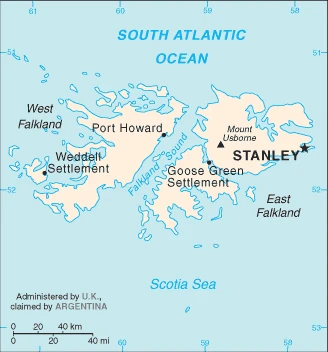
Google Maps Falkland Islands
The capital and other divisions
Capital city: Stanley found under the coordinates 51 42 S, 57 51 W, applying the time zone UTC-4 (1 hour ahead of Washington, DC, during Standard Time), using the following daylight saving time: none.
The Falkland Islands are the most southern British Overseas Territory in the South Atlantic Ocean. The capital, Stanley, draws many visitors for its unique architecture, history, and convenience.
Falkland Islands became independent on none (overseas territory of the UK; also claimed by Argentina), and its national holiday is Liberation Day, 14 June (1982).
Administrative divisions: none (overseas territory of the UK; also claimed by Argentina).
People and society
The population in the Falkland Islands is 3,198 (2016 estimate). Note: data include all persons usually resident in the islands at the 2016 census, with an average of 0.01% (2014 estimate) change. That means the Falkland Islands is the No. 228 in the world’s populated rank list.
The people living in this country are the Falkland Islander(s) (noun) or Falkland Island (adjective) and belong mainly to the following ethnic groups: Falkland Islander 48.3%, British 23.1%, St. Helenian 7.5%, Chilean 4.6%, mixed 6%, other 8.5%, unspecified 2% (2016 estimate). Note: data represent population by national identity.
They speak English 89%, Spanish 7.7%, other 3.3% (2006 estimate) languages and practice the following religions: Christian 57.1%, other 1.6%, none 35.4%, unspecified 6% (2016 estimate).
We can conclude the following about the population in the Falkland Islands: A tiny population, with most residents living in and around Stanley. In the Falkland Islands, we are talking about 78.9% (2021) of the total population is living in cities, and most of them reside in the following municipalities: 2,000 Stanley (capital city) (2018).
Industry
The economy was formerly based on agriculture, mainly sheep farming, but fishing and tourism currently comprise the bulk of economic activity. In 1987, the government began selling fishing licenses to foreign trawlers operating within the Falkland Islands exclusive fishing zone. These license fees net more than $40 million per year, which help support the island’s health, education, and welfare system. The waters around the Falkland Islands are known for their squid, which accounts for around 75% of the annual 200,000-ton catch., Dairy farming supports domestic consumption; crops furnish winter fodder. Foreign exchange earnings come from shipments of high-grade wool to the UK and the sale of postage stamps and coins.
Tourism, especially ecotourism, increased rapidly, with about 69,000 visitors in 2009, and adds approximately $5.5 million to the Falklands annual GDP. The British military presence also provides a sizable economic boost. The islands are now self-financing except for defense. In 1993, the British Geological Survey announced a 200-mile oil exploration zone around the islands, and early seismic surveys suggest substantial reserves capable of producing 500,000 barrels per day. Political tensions between the UK and Argentina remain high following the start of oil drilling activities in the waters. In May 2010, the first commercial oil discovery was made, signaling the potential for developing a long-term hydrocarbon industry in the Falkland Islands.
The Falkland Islands are rich in the following natural resources: Fish, squid, wildlife, calcified seaweed, sphagnum moss.
The main industrial sectors are typically fish and wool processing; tourism.
The country’s export sectors are particularly strong in mollusks, fish, wool, sheep/goat meats, engine parts (2019), partnering with these nations: Spain 78%, United States 6% (2019). The export trade resulted in $257.3 million. Note: Data are in current year dollars (2015 estimate). In a global rank of the export, values resulted in Falkland Islands’ position of 203.
Land use in the Falkland Islands: 0% (2018 estimate) forest, 7.6% (2018 estimate) other.
The arable land area is 0% (2018 estimate), and the agricultural land is 92.4% (2018 estimate). Land use for permanent crops 0% (2018 estimate), permanent pasture 92.4% (2018 estimate).
The main agro-industrial products of Falkland Islands are fodder and vegetable crops; venison, sheep, dairy products; fish, squid.
The country typically needs to import: refined petroleum, spark-ignition engines, stone processing machinery, construction vehicles, cars (2019), partnering with the following nations: the United Kingdom 79%, Netherlands 16% (2019) in a sum value of $90 million (2004 estimate). This sum value on the global ranking list of imports resulted in Falkland Islands 219.
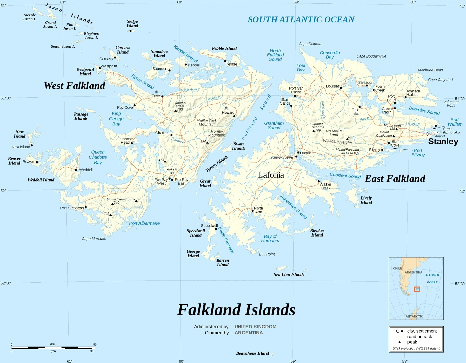
Falkland Islands Driving Directions
In this post, you learned about Falkland Islands, Southern South America, islands in the South Atlantic Ocean, about 500 km east of southern Argentina. We published some basic information about its capital Stanley and the Falkland Islands nation.
Are you interested in visiting the Falkland Islands and looking for driving directions? Click here to plan your route, or see a printable road map of the Falkland Islands below for an overview of the route network.
Printable map of Falkland Islands
Did you know about Falkland Islands?
Did you know that there’s a small archipelago in the South Atlantic Ocean called The Falkland Islands? It’s not one of the most known destinations globally, but it has a fascinating history. In 1820, an Englishman named William Paterson discovered the islands and claimed them for Britain. Over 100 years later, Argentina claimed that these islands were theirs and invaded and occupied the land. There was a 74-day war that ended with Argentina losing this territory to Britain again. The Falkland Islands is not a country but an overseas territory of the United Kingdom.
After virtually visiting the Falkland Islands, you may also be interested in the neighboring countries: none.
If you liked our Google map and the Falkland Islands information page,
please share it with others or save the link https://www.drivingdirections.net in your bookmarks.