
Curacao Google Maps is a site/tool that offers a wide range of map views (topographic, satellite, street view) and navigation options, with little effort on your part, yet efficiently. If you need to plan a trip to a new place like Curacao, Google maps are available on desktop, mobile, or tablet. This Google maps and information page is dedicated to Curacao, Central America, and the Caribbean (35 countries), showing its location, country facts, details about its capital city Willemstad, bordering countries like none, and plenty of other information which may be interesting when you visit this Central American and the Caribbean state.
Quick links: Google Maps Curacao, Willemstad Google maps, Driving Directions Curacao, Printable Road Map.
About Curacao in a nutshell
- Conventional short form of the name: Curacao
- The conventional long form of the name: Country of Curacao
- Local long form: Land Curacao (Dutch) / Pais Korsou (Papiamento)
- Local short form: Curacao (Dutch); Korsou (Papiamento)
- Former name(s): Netherlands Antilles; Curacao and Dependencies
- Etymology: the most plausible name derivation is that the island was designated Isla de la Curacion (Spanish meaning Island of the Cure or Island of Healing) or Ilha da Curacao (Portuguese meaning the same) to reflect the locales function as a recovery stop for sick crewmen.
- The legal system in Curacao: based on Dutch civil law.
- Climate: Tropical marine climate, ameliorated by northeast trade winds, results in mild temperatures, semiarid with average rainfall of 60 cm/year.
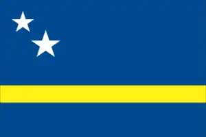
- The national symbols are laraha (citrus tree); national colors: blue, yellow, white.
- Internet TLD: .cw
Background
The original Arawak Indian settlers who arrived on the island from South America in about 1000 were enslaved mainly by the Spanish early in the 16th century and forcibly relocated to other colonies where labor was needed. The Dutch seized curacao from the Spanish in 1634. Once the Caribbean slave trade center, Curacao was hard hit economically by abolishing slavery in 1863. Its prosperity (and neighboring Aruba) was restored in the early 20th century with the Isla Refineria to service the newly discovered Venezuelan oil fields. In 1954, Curacao and several other Dutch Caribbean possessions were reorganized as the Netherlands Antilles, part of the Kingdom of the Netherlands. In referenda in 2005 and 2009, the citizens of Curacao voted to become a self-governing country within the Kingdom of the Netherlands. The change in status became effective in October 2010 with the dissolution of the Netherlands Antilles.
Geography
Curacao is an island in the Dutch Caribbean, part of the Kingdom of the Netherlands. Amerindians inhabited it when Europeans discovered it and subsequently settled in 1499. The first English trading post on mainland South America was established
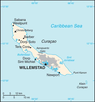
This state is located in the Caribbean, an island in the Caribbean Sea, 55 km off the coast of Venezuela, under the coordinates of 12 10 N, 69 00 W, covering an area of 444 sq km with a coastline of 364 km. Curacao is More than twice the size of Washington, DC.
Generally, low, hilly terrain, with Mt. Christoffel 372 m as the highest point of Curacao, during the Caribbean Sea 0 m as the lowest point. With a total of 444 sq km, Curacao has 444 sq km of land and 0 sq km water surface area.
Curacao is a part of the Windward Islands (southern) group in the Lesser Antilles.
The climate in Curacao is as follows: Tropical marine climate, ameliorated by northeast trade winds, results in mild temperatures, semiarid with an average rainfall of 60 cm/year.
The natural hazards shall be considered when you visit Curacao: Curacao is south of the Caribbean hurricane belt and is rarely threatened.
The following major health-threatening issues shall be considered when visiting Curacao: none.
Current environmental issues affecting the Curacaoan; Dutch people: problems in waste management that threaten environmental sustainability on the island include pollution of marine areas from domestic sewage, inadequate sewage treatment facilities, industrial effluents, and agricultural runoff, the mismanagement of toxic substances, and ineffective regulations; the refinery in Sint Anna Bay, at the eastern edge of Willemstad’s large natural harbor, processes heavy crude oil from Venezuela; it has caused significant environmental damage to the surrounding area because of neglect and a lack of strict environmental controls; the release of toxic fumes and potentially hazardous particles causes schools downwind to regularly close.
Google Maps Curacao
The capital and other divisions
Capital city: Willemstad found under the coordinates 12 06 N, 68 55 W, applying the time zone UTC-4 (1 hour ahead of Washington, DC, during Standard Time), using the following daylight saving time: none.
The beautiful city of Willemstad is located in Curaçao, an island off the coast of Venezuela. It is home to a rich history that dates back to the late 17th century. The city of Willemstad began as a small fishing village in the Caribbean Sea during the early seventeenth century. Now, it is one of the busiest places on Earth. If you’re looking for a relaxing vacation away from the hustle and bustle, this city might be your next destination!
Curacao became independent on none (part of the Kingdom of the Netherlands), and its national holiday is Kings Day (birthday of King WILLEM-ALEXANDER), 27 April (1967).
Administrative divisions: none (part of the Kingdom of the Netherlands) note: Curacao is one of four constituent countries of the Kingdom of the Netherlands; the other three are the Netherlands, Aruba, and Sint Maarten.
People and society
The population in Curacao is 151,885 (July 2021 estimate), with an average of 0.33% (2021 estimate) change. That means Curacao is the No. 187 in the world’s populated rank list. With an average of 36.7 years median age (34.4 years for males and 34.4 years for women), Curacao ranks No. 77 on the globe’s median age rank list.
The people living in this country are the Curacaoan (noun) or Curacaoan; Dutch (adjective) and belong mainly to the following ethnic groups: Curacaoan 75.4%, Dutch 6%, Dominican 3.6%, Colombian 3%, Bonairean, Sint Eustachian, Saban 1.5%, Haitian 1.2%, Surinamese 1.2%, Venezuelan 1.1%, Aruban 1.1%, other 5%, unspecified 0.9% (2011 estimate).
They speak Papiamento (official language) (a creole language that is a mixture of Portuguese, Spanish, Dutch, English, and, to a lesser extent, French, as well as elements of African languages and the language of the Arawak) 80%, Dutch (official language) 8.8%, Spanish 5.6%, English (official language) 3.1%, other 2.3%, unspecified 0.3% (2011 estimate). Note: data represent most spoken language in household languages and practice the following religions: Roman Catholic 72.8%, Pentecostal 6.6%, Protestant 3.2%, Adventist 3%, Jehovahs Witness 2%, Evangelical 1.9%, other 3.8%, none 6%, unspecified 0.6% (2011 estimate).
We can conclude the following about the population in Curacao: Largest concentration on the island is Willemstad. Smaller settlements near the coast can be found throughout the island, particularly the northwest. In Curacao, we are talking about 89.1% (2021) of the total population is living in cities, and most of them reside in the following municipalities: 144,000 Willemstad (capital city) (2018).
Industry
Most of Curacaos GDP results from services. Tourism, petroleum refining and bunkering, offshore finance, and transportation and communications are the mainstays of this small island economy, closely tied to the outside world. Curacao has limited natural resources, poor soil, inadequate water supplies, and budgetary problems that complicate the reform of the health and education systems. Although GDP grew only slightly during the past decade, Curacao enjoys a high per capita income and a well-developed infrastructure compared to other countries in the region. Curacao has an excellent natural harbor that can accommodate large oil tankers, and the port of Willemstad hosts a free trade zone and a dry dock. Venezuelan state-owned oil company PdVSA, under a contract in effect until 2019, leases the single refinery on the island from the government, directly employing some 1,000 people. Most of the oil for the refinery is imported from Venezuela, and most of the refined products are exported to the US and Asia. Almost all consumer and capital goods are imported, with the US, the Netherlands, and Venezuela being the major suppliers.
The government is attempting to diversify its industry and trade. Curacao is an Overseas Country and Territories (OCT) of the European Union. Nationals of Curacao are citizens of the European Union, even though it is not a member. Based on its OCT status, products that originate in Curacao have preferential access to the EU and are exempt from import duties. Curacao is a beneficiary of the Caribbean Basin Initiative. As a result, products originating in Curacao can be imported tax-free into the US if at least 35% has been added to the value of these products in Curacao. The island has state-of-the-art information and communication technology connectivity with the rest of the world, including a Tier IV data center. With several direct satellite and submarine optic fiber cables, Curacao has one of the best Internet speeds and reliability in the Western Hemisphere.
Curacao is rich in the following natural resources: Calcium phosphates, protected harbors, hot springs.
The main industrial sectors are typically tourism, petroleum refining, petroleum transshipment, light manufacturing, financial and business services.
The country’s export sectors are particularly strong in gold, precious metal scraps, petroleum coke, frozen fish, coal tar oil (2019), partnering with these nations: Switzerland 27%, United States 17%, Spain 14%, Ecuador 7%, India 7%, Antigua and Barbuda 5% (2019). The export trade resulted in $1.77 billion. Note: Data are in current year dollars (2019 estimate). In a global rank of the export, values resulted in Curacao’s position of 159.
Land use in Curacao: N/A forest, 90% (2018 estimate) other.
The arable land area is 10% (2018), and the agricultural land is 10% (2018 estimate).
The main agro-industrial products of Curacao are aloe, sorghum, peanuts, vegetables, tropical fruit.
The country typically needs to import: refined petroleum, cars, crude petroleum, packaged medicines, perfumes (2019), partnering with the following nations: the United States 35%, Netherlands 24%, China 5% (2019) in a sum value of $2.33 billion. Note: data are in current year dollars (2019 estimate) $2.75 billion. Note: data are in current year dollars (2018 estimate). This sum value on the global ranking list of imports resulted in Curacao 168.
Curacao Driving Directions
In this post, you learned about Curacao, Caribbean, an island in the Caribbean Sea, 55 km off the coast of Venezuela. We published some basic information about its capital Willemstad, and the Curacao-Dutch nation.
Are you interested in visiting Curacao and looking for driving directions? Click here to plan your route, or see a printable road map of Curacao below for an overview of the route network.
Printable map of Curacao

Did you know about Curacao?
Curacao is an island in the Caribbean. It has a tropical climate that makes for perfect beach weather year-round. The island is known for having some of the most transparent waters in the world. With over 100 miles of white sand beaches, Curacao is one of the most popular tourist destinations in the Caribbean.
After virtually visiting Curacao, you may also be interested in the neighboring countries: none.
If you liked our Google map and Curacao information page,
please share it with others or save the link https://www.drivingdirections.net in your bookmarks.