
Burma Google Maps is a site/tool that offers a wide range of map views (topographic, satellite, street view) and navigation options, with little effort on your part, yet efficiently. If you need to plan a trip to a new place like Burma, Google maps are available on desktop, mobile, or tablet. This Google maps and information page is dedicated to Burma, Southeast Asia (19 countries), showing its location, country facts, details about its capital city Rangoon (Yangon), bordering countries like Bangladesh, China, India, Laos, Thailand, and plenty of other information which may be interesting when you visit this Southeastern Asian state.
Quick links: Google Maps Burma, Rangoon (Yangon) Google maps, Driving Directions Burma, Printable Road Map.
About Burma in a nutshell
- Myanmar is one of the worlds biggest teak exporters, though reserves are diminishing rapidly.
- Conventional short form of the name: Burma
- The conventional long form of the name: Union of Burma
- Local long form: Pyidaungzu Thammada Myanma Naingngandaw (translated as the Republic of the Union of Myanmar)
- Local short form: Myanma Naingngandaw
- Former name(s): Socialist Republic of the Union of Burma, Union of Myanmar
- Etymology: both Burma and Myanmar derive from the name of the majority Burman (Bamar) ethnic group.
- The legal system in Burma: mixed legal system of English common law (as introduced in codifications designed for colonial India) and customary law.
- Climate: Tropical. Hot summers, with high humidity, and warm winters.
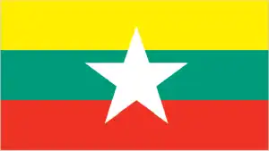
- The national symbols are chinthe (mythical lion); national colors: yellow, green, red, white.
- Internet TLD: .mm
Background
Burma, colonized by Britain in the 19th century and granted independence post-World War II, contains scores of ethnic Burman and ethnic minority groups that have resisted external efforts to consolidate control of the country throughout its history, extending to the several minority groups today that possess independent fighting forces and control pockets of territory. Burman and armed ethnic minorities fought off-and-on until military Gen. NE WIN seized power in 1962. He ruled Burma until 1988, when a military junta took control. In 1990, the junta permitted an election but rejected the results when the main opposition National League for Democracy (NLD) and its leader AUNG SAN SUU KYI won in a landslide. The junta placed AUNG SAN SUU KYI under house arrest for much of the next 20 years, until November 2010.
In 2007, rising fuel prices in Burma led prodemocracy activists and Buddhist monks to launch a Saffron Revolution consisting of large protests against the junta, which violently suppressed the movement by killing an unknown number of participants and arresting thousands. The regime prevented new elections until it had drafted a constitution designed to preserve its control. It passed the new constitution in its 2008 referendum, days after Cyclone Nargis killed at least 138,000. The junta conducted an election in 2010, but the NLD boycotted the vote, and the military’s Union Solidarity and Development Party easily won. International observers denounced the election as flawed. With former or current military officers installed in its most senior positions, Burma began a halting process of political and economic reforms. Officials freed prisoners, brokered minority group ceasefires, amended courts, expanded liberties, brought AUNG SAN SUU KYI into Government in 2012, and permitted the NLD in 2015 to sweep into power. However, Burma’s first credibly elected civilian Government, with AUNG SAN SUU KYI as the de facto head of state, faced strong headwinds after five decades of military dictatorship.
The NLD government drew international criticism for blocking investigations of Burma’s military for operations. The US Department of State determined it constituted ethnic cleansing on its Rohingya population that killed thousands and forced more than 740,000 Rohingya to flee into neighboring countries Bangladesh. The military did not support an NLD pledge in 2019 to examine reforming the military’s 2008 constitution. When the 2020 elections resulted in further NLD gains, the military denounced them fraudulently. This challenge led Commander-in-Chief Sr. General MIN AUNG HLAING to launch a coup in February 2021 that has left Burma reeling with the return to authoritarian rule, the detention of AUNG SAN SUU KYI, and a renewal of the brutal repression of protestors, widespread violence, and economic decline.
Geography
The fertile Irrawaddy basin lies at the center. Mountains to the west, Shan plateau to the east. Tropical rainforest covers much of the land.
In southeast Asia, Myanmar has suffered from isolation, political repression, and ethnic conflict, forming the eastern shores of the Bay of Bengal and the Andaman Sea.
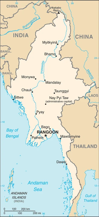
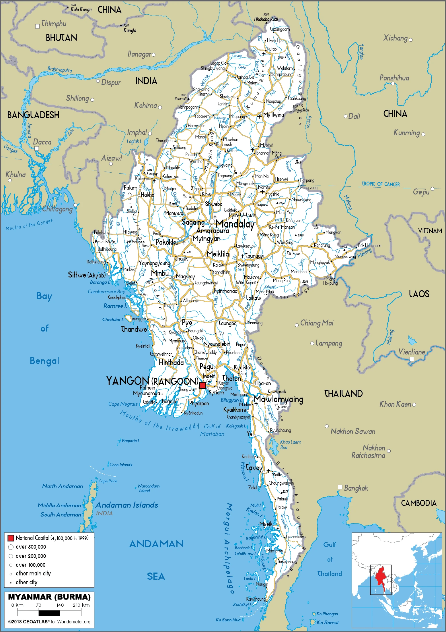
This state is located in Southeastern Asia, bordering the Andaman Sea and the Bay of Bengal, between Bangladesh and Thailand, under the coordinates of 22 00 N, 98 00 E, covering an area of 676,578 sq km with a coastline of 1,930 km. Burma is Slightly smaller than Texas.
Burma has 6,522 km of land boundaries in total and borders with (5 nations): Bangladesh 271 km, China 2129 km, India 1468 km, Laos 238 km, Thailand 2416 km.
Central lowlands are ringed by steep, rugged highlands, with Gamlang Razi 5,870 m as the highest point of Burma, while Andaman Sea/Bay of Bengal 0 m as the lowest point, causing a mean elevation at 702 m throughout the country. With a total of 676,578 sq km, Burma has 653,508 sq km of land and 23,070 sq km water surface area.
The principal rivers are Mekong (shared with China, Laos, Thailand, Cambodia, and Vietnam) – 4,350 km, Salween river mouth (shared with China s and Thailand) – 3,060 km, Irrawaddy river mouth (shared with China) – 2,809 km, Chindwin – 1,158 km. The significant watersheds for Burma are Indian Ocean drainage: Brahmaputra (651,335 sq km), Ganges (1,016,124 sq km), Irrawaddy (413,710 sq km), Salween (271,914 sq km) Pacific Ocean drainage: Mekong (805,604 sq km).
strategic location near major Indian Ocean shipping lanes; the north-south flowing Irrawaddy River is the country’s largest and most important commercial waterway
The climate in Burma is as follows: Tropical monsoon, cloudy, rainy, hot, humid summers (southwest monsoon, June to September), less cloudy, scant rainfall, mild temperatures, lower humidity during winter (northeast monsoon, December to April).
When you visit Burma, the natural hazards shall be considered: Destructive earthquakes and cyclones; flooding and landslides common during the rainy season (June to September); periodic droughts.
The following major health-threatening issues shall be considered when visiting Burma: degree of risk: very high (2020), bacterial and protozoal diarrhea, hepatitis A, typhoid fever, dengue fever, malaria, Japanese encephalitis, rabies.
Current environmental issues affecting the Burmese people: deforestation, industrial pollution of air, soil, and water; inadequate sanitation and water treatment contribute to disease; rapid depletion of the country’s natural resources.
Google Maps Burma
The capital and other divisions
Capital city: Rangoon (Yangon) found under the coordinates 16 48 N, 96 09 E, applying the time zone UTC+6.5 (11.5 hours ahead of Washington, DC, during Standard Time), using the following daylight saving time: none.
Yangon or Rangoon, referred to in English, is the largest city and former capital of Myanmar. It is located on the western bank of the Inya river. Since its founding in the early 19th century, it has been a trading hub for the country, and its people have enjoyed a golden age of commerce here. Today Yangon’s economy relies heavily on manufacturing and service-based industries, but there are still many tourism opportunities.
Burma became independent on 4 January 1948 (from the UK), and its national holiday is Independence Day, 4 January (1948); Union Day, 12 February (1947).
Administrative divisions: 7 regions (taing-myar, singular – taing), 7 states (pyi ne-myar, singular – pyi ne), 1 union territory regions: Ayeyarwady (Irrawaddy), Bago, Magway, Mandalay, Sagaing, Tanintharyi, Yangon (Rangoon) states: Chin, Kachin, Kayah, Kayin, Mon, Rakhine, Shan union territory: Nay Pyi Taw.
People and society
In power from 1962, the military paid little regard to human rights and didn’t tolerate opposition. The National League for Democracy won elections in 1990 but was kept from power. Elections in 2010, nominally restoring civilian rule, were dominated by the new military-backed party. Ethnic minorities are fighting for independence.
The population in Burma is 57,069,099 (July 2021 estimate), with an average of 0.81% (2021 estimate) change. That means Burma is the No. 25 in the world’s populated rank list. With an average of 29.2 years median age (28.3 years for males and 28.3 years for women), Burma ranks No. 133 on the globe’s median age rank list.
The people living in this country are the Burmese (also singular and plural) (noun) or Burmese (adjective) and belong mainly to the following ethnic groups: Burman (Bamar) 68%, Shan 9%, Karen 7%, Rakhine 4%, Chinese 3%, Indian 2%, Mon 2%, other 5%. Note: Government recognizes 135 indigenous ethnic groups.
They speak Burmese (official language) languages and practice the following religions: Buddhist 87.9%, Christian 6.2%, Muslim 4.3%, Animist 0.8%, Hindu 0.5%, other 0.2%, none 0.1% (2014 estimate) note: religion estimate is based on the 2014 national census, including an estimate for the non-enumerated population of Rakhine State, which is assumed to mainly affiliate with the Islamic faith; as of December 2019, Muslims probably make up less than 3% of Burma’s total population due to the significant outmigration of the Rohingya population since 2017.
We can conclude the following about the population in Burma: Population concentrated along with coastal areas and in general proximity to the shores of the Irrawaddy River. The extreme north is relatively underpopulated. In Burma, we are talking about 31.4% (2021) of the total population is living in cities, and most of them reside in the following municipalities: 5.422 million, Rangoon (Yangon) (capital city), 1.469 million, Mandalay (2021).
Industry
Corrupt, mismanaged, subject to sanctions but gas, teak, and gems are exported. One of the world’s largest illegal opium producers. Goods sold on the black market carry high prices.
Since Burma began the transition to a civilian-led government in 2011, the country initiated economic reforms to attract foreign investment and reintegrate into the global economy. Burma established a managed float of the Burmese kyat in 2012, granted the Central Bank operational independence in July 2013, enacted a new anti-corruption law in September 2013, and granted licenses to 13 foreign banks in 2014-16. State Counsellor AUNG SAN SUU KYI and the ruling National League for Democracy, who took power in March 2016, have sought to improve Burma’s investment climate following the US sanctions lift in October 2016 and reinstatement of Generalized System of Preferences trade benefits in November 2016.
In October 2016, Burma passed a foreign investment law that consolidates investment regulations and eases rules on foreign ownership of businesses. Burma’s economic growth rate recovered from a low growth under 6% in 2011 but has been volatile between 6% and 8% between 2014 and 2018. Burma’s abundant natural resources and young labor force can attract foreign investment in the energy, garment, information technology, and food and beverage sectors.
The Government focuses on accelerating agricultural productivity and land reforms, modernizing and opening the financial sector, and developing transportation and electricity infrastructure. The Government has also taken steps to improve transparency in the mining and oil sectors by publishing reports under the Extractive Industries Transparency Initiative (EITI) in 2016 and 2018. Despite these improvements, living standards have not improved for the majority of the people residing in rural areas. Burma remains one of the poorest countries in Asia approximately 26% of the country’s 51 million people live in poverty.
The isolationist policies and economic mismanagement of the previous Governments have left Burma with poor infrastructure, endemic corruption, underdeveloped human resources, and inadequate access to capital, which will require a significant commitment to reverse. The Burmese Government has been slow to address impediments to economic development such as unclear land rights, a restrictive trade licensing system, an opaque revenue collection system, and an antiquated banking system.
Burma is rich in the following natural resources: Petroleum, timber, tin, antimony, zinc, copper, tungsten, lead, coal, marble, limestone, precious stones, natural gas, hydropower, arable land.
The main industrial sectors are typically agricultural processing; wood and wood products; copper, tin, tungsten, iron; cement, construction materials; pharmaceuticals; fertilizer; oil and natural gas; garments; jade and gems.
The country’s export sectors are particularly strong in natural gas, clothing products, rice, copper, dried legumes (2019), partnering with these nations: China 24%, Thailand 24%, Japan 7%, Germany 5% (2019). The export trade resulted in $17.52 billion. Note: Data are in current year dollars (2019 estimate). In a global rank of the export, values resulted in Burma’s position of 88.
Land use in Burma: 48.2% (2018 estimate) forest, 32.6% (2018 estimate) other.
The arable land area is 16.5% (2018 estimate), and the agricultural land is 19.2% (2018 estimate). Land use for permanent crops 2.2% (2018 estimate), permanent pasture 0.5% (2018 estimate). The sum of the area of the irrigated land is 22,950 sq km (2012).
The main agro-industrial products of Burma are rice, sugar cane, beans, vegetables, milk, maize, poultry, groundnuts, fruit, plantains.
The country typically needs to import: refined petroleum, broadcasting equipment, fabrics, motorcycles, packaged medicines (2019), partnering with the following nations: China 43%, Thailand 15%, Singapore 12%, Indonesia 5% (2019) in a sum value of $17.36 billion. Note: data are in current year dollars (2019 estimate) $18.66 billion. Note: data are in current year dollars (2018 estimate). Note: import figures are grossly underestimated due to the value of consumer goods, diesel fuel, and other products smuggled in from Thailand, China, Malaysia, and India. This sum value on the global ranking list of imports resulted in Burma 93.
Burma Driving Directions
In this post, you learned about Burma, Southeastern Asia, bordering the Andaman Sea and the Bay of Bengal, between Bangladesh and Thailand. We published some basic information about its capital Rangoon (Yangon), and the Burmese nation.
Are you interested in visiting Burma and looking for driving directions? Click here to plan your route, or see a printable road map of Burma below for an overview of the route network.
Printable map of Burma
Did you know about Burma?
The country was formerly called Burma until 1989, when it changed its name to Myanmar. It has many different ethnic groups and languages. These ethnic groups are Karen, Chin, Kachin, Karenni, Mon, Rakhine, and Shan. The Burmese language is the official language of the country.
After virtually visiting Burma, you may also be interested in the neighboring countries: Bangladesh, China, India, Laos, Thailand.
If you liked our Google map and Burma information page,
please share it with others or save the link https://www.drivingdirections.net in your bookmarks.