
British Indian Ocean Territory Google Maps is a site/tool that offers a wide range of map views (topographic, satellite, street view) and navigation options, with little effort on your part, yet efficiently. If you need to plan a trip to a new place like the British Indian Ocean Territory, Google maps are available on desktop, mobile, or tablet. This Google maps and information page is dedicated to British Indian Ocean Territory, Political Map of the World (1 country), showing its location, country facts, details about its capital city N/A, bordering countries like none, and plenty of other information which may be interesting when you visit this British Indian and Oceanian state.
Quick links: Google Maps British Indian Ocean Territory, N/A Google maps, Driving Directions British Indian Ocean Territory, Printable Road Map.
About British Indian Ocean Territory in a nutshell
- Conventional short form of the name: none
- The conventional long form of the name: British Indian Ocean Territory
- Etymology: self-descriptive name specifying the territorys affiliation and location.
- The legal system in British Indian Ocean Territory: the laws of the UK apply where applicable.
- Climate: Tropical marine, hot, humid, moderated by trade winds.
- The national symbols are N/A.
- Internet TLD: .io
Background
Formerly administered as part of the British Crown Colony of Mauritius, British Indian Ocean Territory (BIOT) was established overseas in 1965. A number of the territory islands were later transferred to Seychelles when it attained independence in 1976. Subsequently, BIOT has consisted only of the six main island groups comprising the Chagos Archipelago. Only Diego Garcia, the largest and most southerly island, is inhabited. It contains a joint UK-US naval support facility and hosts one of four dedicated ground antennas that assist in the operation of the Global Positioning System (GPS) navigation system (the others are on Kwajalein (Marshall Islands), at Cape Canaveral, Florida (US), and on Ascension Island (Saint Helena, Ascension, and Tristan da Cunha)).
The US Air Force also operates a telescope array on Diego Garcia as part of the Ground-Based Electro-Optical Deep Space Surveillance System (GEODSS) for tracking orbital debris, which can be a hazard to spacecraft and astronauts. Between 1967 and 1973, former agricultural workers, earlier residents in the islands, were relocated primarily to Mauritius and Seychelles. Negotiations between 1971 and 1982 resulted in establishing a trust fund by the British Government as compensation for the displaced islanders, known as Chagossians. In 1998, the islanders pursued a series of lawsuits against the British Government seeking further compensation and the right to return to the territory.
In 2006 and 2007, British court rulings invalidated the immigration policies contained in the 2004 BIOT Constitution Order that had excluded the islanders from the archipelago but upheld the special military status of Diego Garcia. In 2008, the House of Lords, as the final court of appeal in the UK, ruled in favor of the British Government by overturning the lower court rulings and finding no right of return for the Chagossians.
In March 2015, the Permanent Court of Arbitration unanimously held that the marine protected area (MPA) that the UK declared around the Chagos Archipelago in April 2010 violated the UN Convention on the Law of the Sea. In February 2019, the International Court of Justice ruled in an advisory opinion that Britain’s decolonization of Mauritius was not completed lawfully because of continued Chagossian claims. A non-binding May 2019 UN General Assembly vote demanded that Britain end its colonial administration of the Chagos Archipelago and return it to Mauritius. UK officials defend Britain’s sovereignty over the islands and argue that the issue is a bilateral dispute between Mauritius and the UK that does not warrant international intervention. ,
Geography
This state is located in the archipelago in the Indian Ocean, south of India, about halfway between Africa and Indonesia, under the coordinates of 6 00 S, 71 30 E, covering an area of 60 sq km with a coastline of 698 km. British Indian Ocean Territory is Land area is about one-third of Washington, DC.
Flat and low (most areas do not exceed two m in elevation), Ocean-side dunes on Diego Garcia 9 m as the highest point of British Indian Ocean Territory, while Indian Ocean 0 m as the lowest point, causing a mean elevation at N/A throughout the country. With a total of 60 sq km, British Indian Ocean Territory has 60 sq km (44 Diego Garcia) of land and 54,340 sq km water surface area.
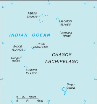
The archipelago of 55 islands, Diego Garcia, the largest and southernmost island, occupies a strategic location in the central Indian Ocean; the island is the site of a joint US-UK military facility.
The climate in British Indian Ocean Territory is as follows: Tropical marine, hot, humid, moderated by trade winds.
When you visit British Indian Ocean Territory, the natural hazards shall be considered: None; located outside routes of indian ocean cyclones.
The following major health-threatening issues shall be considered when visiting British Indian Ocean Territory.
Current environmental issues affecting the people: wastewater discharge into the lagoon on Diego Garcia.
Google Maps British Indian Ocean Territory
The capital and other divisions
British Indian Ocean Territory is a self-governing territory of the United Kingdom located in the Indian Ocean. It consists of the islands of the Chagos Archipelago, which include Diego Garcia and Peros Banhos. Its only landmass is the island of Diego Garcia, where most of the population resides. The rest of the territory’s population resides on Peros Banhos, a small island about 4 kilometers (2.4 mi) away.
People and society
The population in British Indian Ocean Territory is no indigenous inhabitants. Note: approximately 1,200 former agricultural workers resident in the Chagos Archipelago, often referred to as Chagossians or Ilois, were relocated to Mauritius and Seychelles in the 1960s and 1970s; approximately 3,000 UK and US military personnel and civilian contractors living on the island of Diego Garcia (2018), with an average of N/A change.
Industry
All economic activity is concentrated on the largest island of Diego Garcia, where a joint UK-US military facility is located. Construction projects and various services needed to support the military installation are performed by military and contract employees from the UK, Mauritius, the Philippines, and the US. Some of the natural resources found in this territory include coconuts, fish, and sugarcane.
British Indian Ocean Territory is rich in natural resources: Coconuts, fish, sugarcane.
Land use in British Indian Ocean Territory: 0% (2018 estimate) forest, 100% (2018 estimate) other.
The arable land area is 0% (2018 estimate), and the agricultural land is 0% (2018 estimate). Land use for permanent crops 0% (2018 estimate), permanent pasture 0% (2018 estimate).
British Indian Ocean Territory Driving Directions
In this post, you learned about British Indian Ocean Territory, an archipelago in the Indian Ocean, south of India, halfway between Africa and Indonesia.
Are you interested in visiting British Indian Ocean Territory and looking for driving directions? Click here to plan your route, or see a printable road map of the British Indian Ocean Territory below for an overview of the route network.
Printable map of British Indian Ocean Territory
Did you know about British Indian Ocean Territory?
This overseas territory of the United Kingdom was first established as a colony in 1857. It includes the island of Diego Garcia, which is home to a significant American military base.
It consists of two separate groups: the Chagos Islands, while the other includes the three main archipelagos in the Indian Ocean, namely, Aldabra, Farquhar, and Desroches.
After virtually visiting British Indian Ocean Territory, you may also be interested in the neighboring countries: none.
If you liked our Google map and the British Indian Ocean Territory information page,
please share it with others or save the link https://www.drivingdirections.net in your bookmarks.