
Cook Islands Google Maps is a site/tool that offers a wide range of map views (topographic, satellite, street view) and navigation options, with little effort on your part, yet efficiently. If you need to plan a trip to a new place like the Cook Islands, Google maps are available on desktop, mobile, or tablet. This Google maps and information page is dedicated to the Cook Islands, Oceania (27 countries), showing its location, country facts, details about its capital city Avarua, bordering countries, and plenty of other information which may be interesting when you visit this Oceanian state.
Quick links: Google Maps Cook Islands, Avarua Google maps, Driving Directions Cook Islands, Printable Road Map.
About Cook Islands in a nutshell
- Conventional short form of the name: Cook Islands
- The conventional long form of the name: none
- Former name(s): Hervey Islands
- Etymology: named after Captain James COOK, the British explorer who visited the islands in 1773 and 1777.
- The legal system in Cook Islands: common law similar to New Zealand common law.
- Climate: Tropical oceanic, moderated by trade winds, a dry season from April to November, and a more humid season from December to March.
- The national symbols are a circle of 15, five-pointed, white stars on a blue field, Tiare maori (Gardenia taitensis) flower; national colors: green, white.
- Internet TLD: .ck
Background
Polynesians from Tahiti were probably the first people to settle Rarotonga around A.D. 900. Over time, Samoans and Tongans also settled in Rarotonga, and Rarotongans voyaged to the northern Cook Islands, settling Manihiki and Rakahanga. Pukapuka and Penrhyn in the northern Cook Islands were settled directly from Samoa. Before European contact, there was considerable travel and trade between inhabitants of the different islands and atolls, but they were not united in a single entity. Spanish navigators were the first Europeans to spot the northern Cook Islands in 1595, followed by the first landing in 1606. The Cook Islands remained free of further European contact until the 1760s, and in 1773, British explorer James COOK saw Manuae in the southern Cook Islands. The islands were named after COOK in the 1820s by Russian mapmakers.
English missionary activity during the 1820s and 1830s banned singing and dancing and converted most of the population. Fearing France would militarily occupy the islands as it did in Tahiti, Rarotongans asked the U.K. for protectorate status in the 1840s and 1860s, which the U.K. ignored. In 1888, Queen MAKEA TAKAU of Rarotonga formally petitioned for protectorate status, which the U.K. reluctantly agreed to. In 1901, the U.K. placed Rarotonga and the rest of the islands in the New Zealand Colony, and in 1915, the Cook Islands Act organized the Cook Islands into one political entity.
It remained a protectorate until 1965 when New Zealand granted the Cook Islands self-government status. The Cook Islands has a great deal of local autonomy. It is an independent member of international organizations, but it is in free association with New Zealand, responsible for defense and foreign affairs. Economic opportunities in the Cook Islands are sparse, and more Cook Islanders live in New Zealand than in the Cook Islands. In a referendum in 1994, voters chose to keep the name Cook Islands rather than changing to a Maori name for the islands. The issue was revived in 2019, but after being poorly received by the diaspora in New Zealand, the government decided to retain the name Cook Islands but provide a Maori name alongside it. The Maori name has not yet been determined.
Geography
The Cook Islands is a British Overseas Territory in the South Pacific Ocean. They are an archipelago of fifteen islands with roughly 68 square miles, making it one of the world’s smallest states.
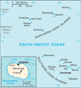
This state is located in Oceania, a group of islands in the South Pacific Ocean, about halfway between Hawaii and New Zealand, under the coordinates of 21 14 S, 159 46 W, covering an area of 236 sq km with a coastline of 120 km. Cook Islands is 1.3 times the size of Washington, DC.
Low coral atolls in the north, volcanic, hilly islands in the south, with Te manga 652 m as the highest point of Cook Islands, while Pacific Ocean 0 m as the lowest point. With a total of 236 sq km, Cook Islands has 236 sq km of land and 0 sq km water surface area.
The northern Cook Islands are seven low-lying, sparsely populated coral atolls; the southern Cook Islands, where most of the population lives, consist of eight elevated, fertile, volcanic isles, including the largest, Rarotonga, at 67 sq km.
The climate in the Cook Islands is as follows: Tropical oceanic, moderated by trade winds, a dry season from April to November, and a more humid season from December to March.
When you visit the Cook Islands, the natural hazards shall be considered: Tropical cyclones (November to March).
The following major health-threatening issues shall be considered when visiting the Cook Islands: degree of risk: high (2020), bacterial diarrhea, malaria.
Current environmental issues affecting the Cook Islander people: limited land presents solid and liquid waste disposal problems; soil destruction and deforestation; environmental degradation due to indiscriminate use of pesticides; improper disposal of pollutants; overfishing and destructive fishing practices; over dredging of lagoons and coral rubble beds; unregulated building.
Google Maps Cook Islands
The capital and other divisions
Capital city: Avarua found under the coordinates 21 12 S, 159 46 W, applying the time zone UTC-10 (5 hours behind Washington, DC, during Standard Time), using the following daylight saving time: none.
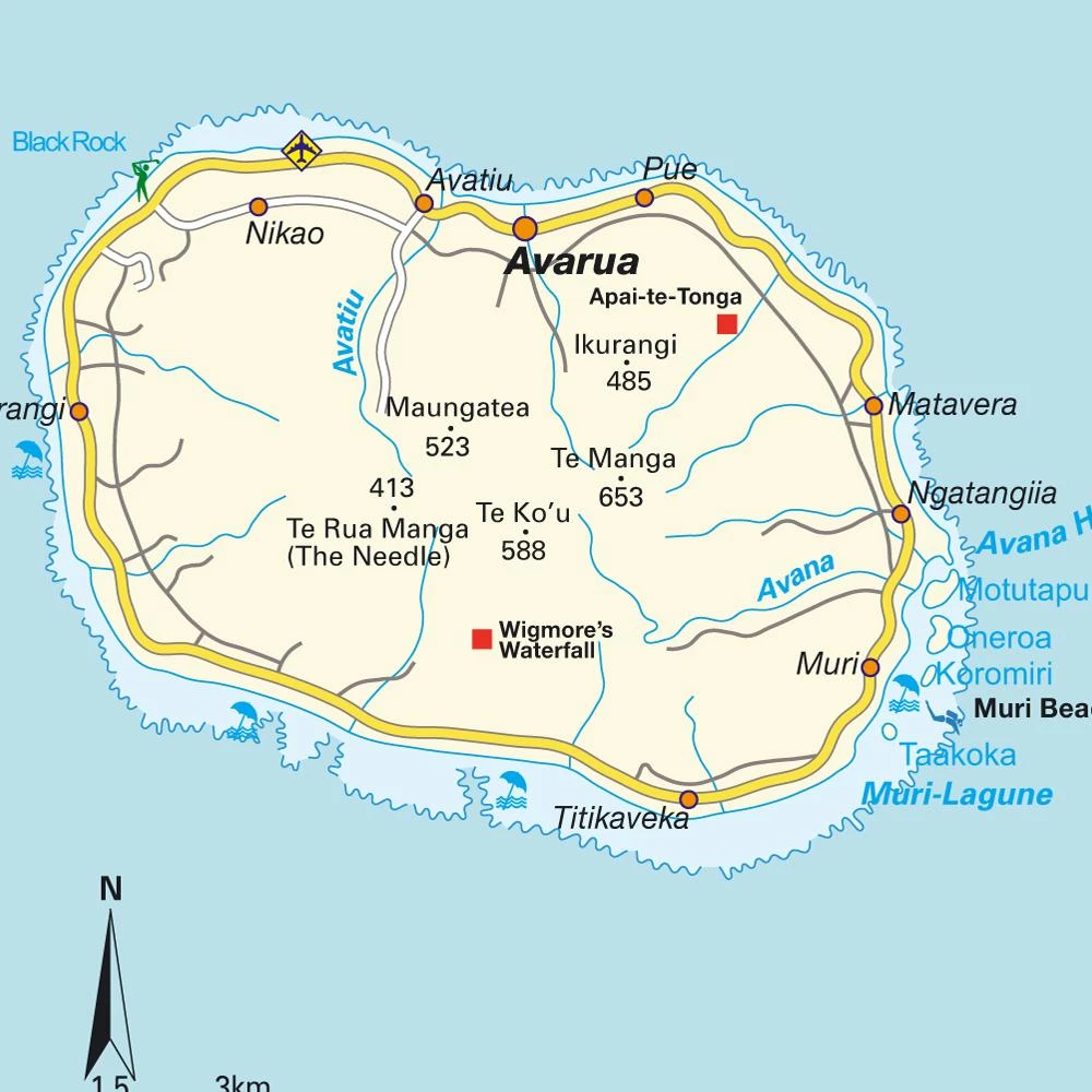
Avarua starts with the letter “A” so it’s easy to remember. Avarua is the capital city of the Cook Islands, located on the eastern side of the island of Rarotonga. The word “avaru” means thirst in Tahitian.
The Cook Islands became independent on none (became self-governing in free association with New Zealand on 4 August 1965 with the right at any time to move to complete independence by unilateral action), and its national holiday is Constitution Day, the first Monday in August (1965).
Administrative divisions: none.
People and society
The population in the Cook Islands is 8,327 (July 2021 estimate). Note: the Cook Islands Ministry of Finance & Economic Management estimated the resident population to have been 11,700 in September 2016, with an average of -2.46% (2021 estimate) change. That means the Cook Islands is the No. 223 in the world’s populated rank list. With an average of 38.3 years median age (37.8 years for males and 37.8 years for women), Cook Islands ranks No. 64 on the globe’s median age rank list.
The people living in this country are the Cook Islander(s) (noun) or Cook Islander (adjective) and belong mainly to the following ethnic groups: Cook Island Maori (Polynesian) 81.3%, part Cook Island Maori 6.7%, other 11.9% (2011 estimate).
They speak English (official language) 86.4%, Cook Islands Maori (Rarotongan) (official language) 76.2%, other 8.3% (2011 estimate). Note: shares sum to more than 100% because some respondents gave more than one answer on the census languages and practice the following religions: Protestant 62.8% (Cook Islands Christian Church 49.1%, Seventh Day Adventist 7.9%, Assemblies of God 3.7%, Apostolic Church 2.1%), Roman Catholic 17%, Church of Jesus Christ 4.4%, other 8%, none 5.6%, no response 2.2% (2011 estimate).
We can conclude the following about the population in the Cook Islands: Most of the population is found on the island of Rarotonga. In the Cook Islands, we are talking about 75.7% (2021) of the total population is living in cities.
Industry
Like many other South Pacific island nations, the Cook Islands’ economic development is hindered by the country’s isolation from foreign markets, the limited size of domestic markets, lack of natural resources, periodic devastation from natural disasters, and inadequate infrastructure.
Agriculture, employing more than one-quarter of the working population, provides the economic base with significant exports of copra and citrus fruit. Black pearls are the Cook Islands’ leading export. Manufacturing activities are limited to fruit processing, clothing, and handicrafts. Trade deficits are offset by emigrant remittances and foreign aid overwhelmingly from New Zealand. In the 1980s and 1990s, the country became overextended, maintaining a bloated public service and accumulating sizeable foreign debt. Subsequent reforms, including the sale of state assets, the strengthening of economic management, the encouragement of tourism, and a debt restructuring agreement, have rekindled investment and growth. The government targets fisheries and seabed mining as sectors for future economic growth.
The Cook Islands is rich in natural resources: Coconuts (copra).
The main industrial sectors are typically fishing, fruit processing, tourism, clothing, handicrafts.
The country’s export sectors are particularly strong in fish products, recreational boats, precious metal scraps, fruit juice, chemical analysis instruments (2019), partnering with these nations: Japan 37%, Thailand 21%, France 17% (2019). The export trade resulted in $3.125 million. Note: Data are in current year dollars (2011 estimate). In a global rank of the export, values resulted in Cook Islands’s position of 223.
Land use in Cook Islands: 64.6% (2018 estimate) forest, 27% (2018 estimate) other.
The arable land area is 4.2% (2018 estimate), and the agricultural land is 8.4% (2018 estimate). Land use for permanent crops 4.2% (2018 estimate), permanent pasture 0% (2018 estimate).
The main agro-industrial products of Cook Islands are vegetables, coconuts, roots/tubers nes, cassava, papayas, tomatoes, pork, fruit, sweet potatoes, mangoes/guavas.
The country typically needs to import: ships, refined petroleum, recreational boats, cars, flavored water (2019), partnering with the following nations: New Zealand 41%, China 21%, Italy 12%, Fiji 10% (2019) in a sum value of $109.3 million (2011 estimate) $90.62 million (2010 estimate). This sum value on the global ranking list of imports resulted in Cook Islands 217.
Cook Islands Driving Directions
In this post, you learned about Cook Islands, Oceania, a group of islands in the South Pacific Ocean, about halfway between Hawaii and New Zealand. We published some basic information about its capital Avarua, and the Cook Islander nation.
Are you interested in visiting the Cook Islands and looking for driving directions? Click here to plan your route, or see a printable road map of the Cook Islands below for an overview of the route network.
Printable map of Cook Islands
Did you know about the Cook Islands?
The Cook Islands are a self-governing country, part of the Commonwealth of Nations. It is made up of 15 islands located in the South Pacific Ocean. The country was first settled by Polynesians long before Europeans arrived. Captain James Cook discovered the islands in 1773; they got their name.
After virtually visiting the Cook Islands, you may also be interested in the neighboring countries: none.
If you liked our Google map and the Cook Islands information page,
please share it with others or save the link https://www.drivingdirections.net in your bookmarks.