
French Polynesia Google Maps is a site/tool that offers a wide range of map views (topographic, satellite, street view) and navigation options, with little effort on your part, yet efficiently. If you need to plan a trip to a new place like French Polynesia, Google maps are available on desktop, mobile, or tablet. This Google maps and information page is dedicated to French Polynesia, Oceania (27 countries), showing its location, country facts, details about its capital city Papeete (located on Tahiti), and plenty of other information which may be interesting when you visit this Oceanian state.
Quick links: Google Maps French Polynesia, Papeete (located on Tahiti) Google maps, Driving Directions French Polynesia, Printable Road Map.
About French Polynesia in a nutshell
- Conventional short form of the name: French Southern and Antarctic Lands
- The conventional long form of the name: Territory of the French Southern and Antarctic Lands
- Local long form: Territoire des Terres Australes et Antarctiques Francaises
- Local short form: Terres Australes et Antarctiques Francaises
- Former name(s): Establishments in Oceania, French Establishments in Oceania
- Etymology: self-descriptive name specifying the territories affiliation and location in the Southern Hemisphere.
- The legal system in French Polynesia: the laws of France, where applicable, apply French Southern and Antarctic Lands the laws of France, where applicable, apply.
- Climate: Tropical, but moderate french southern and antarctic lands.
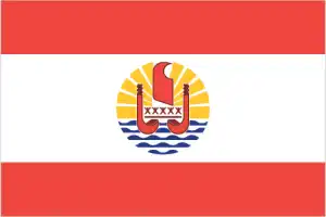
- The national symbols are outrigger canoe, Tahitian gardenia (Gardenia taitensis) flower; national colors: red, white.
- Internet TLD: .pf
Background
French Polynesia consists of five archipelagos – the Austral Islands, the Gambier Islands, the Marquesas Islands, the Society Islands, and the Tuamotu Archipelago. The Marquesas were first settled around 200 B.C. and the Society Islands around A.D. 300. Raiatea in the Society Islands became a center for religion and culture. Exploration of the other islands emanated from Raiatea, and by 1000, there were small permanent settlements in all the island groups. Ferdinand MAGELLAN was the first European to see the islands of French Polynesia in 1520, and successive European voyagers traveled through them over the next two centuries. In 1767, British explorer Samuel WALLIS was the first European to visit Tahiti, followed by French navigator Louis Antoine de BOUGAINVILLE in 1768, and British explorer James COOK in 1769. King POMARE I united Tahiti and surrounding islands into the Kingdom of Tahiti in 1788. Protestant missionaries arrived in 1797, and Pomare, Is successor, converted in the 1810s, along with most Tahitians. In the 1830s, Queen POMARE IV refused to allow French Catholic missionaries to operate, leading France to declare a protectorate over Tahiti and fight the French-Tahitian War of the 1840s in an attempt to annex the islands. POMARE IV requested British assistance to fight France, and while the U.K. did not provide material support, it diplomatically pressured France to maintain its protectorate status.
In 1880, King POMARE V ceded Tahiti and its possessions to France, changing its status into a colony. France then claimed the Gambier Islands and the Tuamotu Archipelago and by 1901 had incorporated all five island groups into its establishments in Oceania. A Tahitian nationalist movement formed in 1940, leading France to grant French citizenship to the islanders in 1946 and change it to an overseas territory. In 1957, the island’s name was changed to French Polynesia, and the following year, 64% of voters chose to stay part of France when they approved a new constitution. Uninhabited Mururoa Atoll was established as a French nuclear test site in 1962, and tests were conducted between 1966 and 1992 (underground beginning in 1975). France also conducted tests at Fangataufa Atoll, including its last nuclear test in 1996.
France granted French Polynesia partial internal autonomy in 1977 and expanded autonomy in 1984. French Polynesia was converted into an overseas collectivity in 2003 and renamed an overseas country inside the Republic in 2004. Pro-independence politicians won a surprise majority in local elections that same year but were relegated to a vocal minority in subsequent elections. In 2013, French Polynesia was relisted on the UN List of Non-Self Governing Territories.
Geography
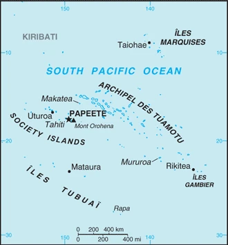
French Polynesia is an overseas collectivity in the Pacific Ocean, composed of 118 islands and atolls stretching over 2,000 kilometers between the five archipelagos of Tuamotu, Gambier Islands, Clipperton Island, Tubuai, and Marie-Galante.
This state is located in Oceania, five archipelagoes (Archipel des Tuamotu, Iles Gambier, Iles Marquises, Iles Tubuai, Society Islands) in the South Pacific Ocean about halfway between South America and Australia French Southern and Antarctic Lands southeast and east of Africa, islands in the southern Indian Ocean, some near Madagascar and others about equidistant between Africa, Antarctica, and Australia, under the coordinates of 15 00 S, 140 00 W, covering an area of 4,167 sq km with a coastline of 2,525 km. French Polynesia is Slightly less than one-third the size of Connecticut.
Mixture of rugged high islands and low islands with reefs french southern and antarctic lands ile amsterdam (ile amsterdam et ile saint-paul): a volcanic island with steep coastal cliffs, the center floor of the volcano is a large plateau, ile saint-paul (ile amsterdam et ile saint-paul): triangular in shape, the island is the top of a volcano, rocky with steep cliffs on the eastern side, has active thermal springs, iles crozet: a large archipelago formed from the crozet plateau is divided into two groups of islands, iles kerguelen: the interior of the large island of ile kerguelen is composed of high mountains, hills, valleys, and plains with peninsulas stretching off its coasts, Bassas da India (Iles Eparses): atoll, awash at high tide, shallow (15 m) lagoon, Europa Island, Glorioso Islands, Juan de Nova Island: low, flat, and sandy, Tromelin Island (Iles Eparses): low, flat, sandy, likely volcanic seamount, with Mont de la Dives on Ile Amsterdam (Ile Amsterdam et Ile Saint-Paul) 867 m as the highest point of French Polynesia, while Indian Ocean 0 m as the lowest point. With 4,167 sq km, French Polynesia has 3,827 sq km of land and 340 sq km water surface area.
Includes five archipelagoes: four volcanic (Iles Gambier, Iles Marquises, Iles Tubuai, Society Islands) and one coral (Archipel des Tuamotu); the Tuamotu Archipelago forms the largest group of atolls in the world – 78 in total, 48 inhabited; Makatea in the Tuamotu Archipelago is one of the three great phosphate rock islands in the Pacific Ocean – the others are Banaba (Ocean Island) in Kiribati and Nauru French Southern, and Antarctic Lands islands component is widely scattered across remote locations in the southern Indian Ocean, Bassas da India (Iles Eparses): atoll is a circular reef atop a long-extinct, submerged volcano; Europa Island and Juan de Nova Island (Iles Eparses): wildlife sanctuary for seabirds and sea turtles; Glorioso Island (Iles Eparses): islands and rocks are surrounded by an extensive reef system; Tromelin Island (Iles Eparses): climatologically important location for forecasting cyclones in the western Indian Ocean; wildlife sanctuary (seabirds, tortoises).
The climate in French Polynesia is as follows: Tropical, but moderate french southern and antarctic lands. Ile Amsterdam et Ile Saint-Paul: oceanic with persistent westerly winds and high humidity, Iles Crozet: windy, cold, wet, and cloudy, Iles Kerguelen: oceanic, cold, overcast, windy, Iles Eparses: tropical.
When you visit French Polynesia, the natural hazards shall be considered: Occasional cyclonic storms in January french southern and antarctic lands Ile Amsterdam and Ile Saint-Paul are inactive volcanoes; Iles Eparses subject to periodic cyclones; Bassas da India is a maritime hazard since it is underwater for three hours before and following the high tide and surrounded by reefs volcanism: Reunion Island – Piton de la Fournaise (2,632 m), which has erupted many times in recent years including 2010, 2015, and 2017, is one of the worlds most active volcanoes; although rare, eruptions outside the volcano’s caldera could threaten nearby cities.
The following major health-threatening issues shall be considered when visiting French Polynesia: degree of risk: high (2020), bacterial diarrhea, malaria.
Current environmental issues affecting the French Polynesian people: sea-level rise; extreme weather events (cyclones, storms, and tsunamis producing floods, landslides, erosion, and reef damage); droughts; freshwater scarcity French Southern and Antarctic Lands introduction of foreign species on Iles Crozet has caused severe damage to the original ecosystem; overfishing of Patagonian toothfish around Iles Crozet and Iles Kerguelen.
Google Maps French Polynesia
The capital and other divisions
Capital city: Papeete (located on Tahiti) found under the coordinates 17 32 S, 149 34 W, applying the time zone UTC-10 (5 hours behind Washington, DC, during Standard Time), using the following daylight saving time: none.
Papeete is the capital of Tahiti and the most populous city in French Polynesia. It has a population of 315,000 people and boasts an astounding amount of bright, sunny days per year. As a result of these natural conditions, Papeete is considered one of the world’s healthiest cities.
French Polynesia became independent on none (overseas lands of France), and its national holiday is Fete de la Federation, 14 July (1790);.
Administrative divisions: 5 administrative subdivisions (subdivisions administratives, singular – subdivision administrative): Iles Australes (Austral Islands), Iles du Vent (Windward Islands), Iles Marquises (Marquesas Islands), Iles Sous-le-Vent (Leeward Islands), Iles Tuamotu-Gambier.
People and society
The population in French Polynesia is 297,154 (July 2021 estimate). French Southern and Antarctic Lands no indigenous inhabitants Ile Amsterdam (Ile Amsterdam et Ile Saint-Paul): uninhabited but has a meteorological station Ile Saint-Paul (Ile Amsterdam et Ile Saint-Paul): uninhabited but is frequently visited by anglers and has a scientific research cabin for short stays Iles Crozet: uninhabited except for 18 to 30 people staffing the Alfred Faure research station on Ile de la Possession Iles Kerguelen: 50 to 100 scientists are located at the main base at Port-aux-Francais on Ile Kerguelen Bassas da India (Iles Eparses): uninhabitable Europa Island, Glorioso Islands, Juan de Nova Island (Iles Eparses): a small French military garrison and a few meteorologists on each possession; visited by scientists Tromelin Island (Iles Eparses): uninhabited, except for visits by scientists, with an average of 0.75% (2021 estimate) change. That means French Polynesia is the No. 181 in the world’s populated rank list. With an average of 33.3 years median age (33 years for males and 33 years for women), French Polynesia ranks No. 98 on the globe’s median age rank list.
The people living in this country are the French Polynesian(s) (noun) or French Polynesian (adjective) and belong mainly to the following ethnic groups: Polynesian 78%, Chinese 12%, local French 6%, metropolitan French 4%.
They speak French (official language) 70%, Polynesian (official language) 28.2%, other 1.8% (2012 estimate) languages and practice the following religions: Protestant 54%, Roman Catholic 30%, other 10%, no religion 6%.
We can conclude the following about the population in French Polynesia: The majority of the population lives in the society islands, one of five archipelagos that include the most populous island – Tahiti – with approximately 70% of the nation’s population. In French Polynesia, we are talking about 62.1% (2021) of the total population is living in cities, and most of them reside in the following municipalities: 136,000 Papeete (capital city) (2018).
Industry
Since 1962, when France stationed military personnel in the region, French Polynesia has changed from a subsistence agricultural economy to one in which a high proportion of the workforce is employed by the military or supports the tourist industry. With the halt of French nuclear testing in 1996, the military contribution to the economy fell sharply. After growing at an average yearly rate of 4.2% from 1997-2007, the economic and financial crisis in 2008 marked French Polynesia’s entry into recession. However, since 2014, French Polynesia has shown signs of recovery. Business turnover reached 1.8% year-on-year in September 2016, tourism increased 1.8% in 2015, and GDP grew 2.0% in 2015. French Polynesia’s tourism-dominated service sector accounted for 85% of total value added for the economy in 2012. Tourism employs 17% of the workforce.
Pearl farming is the second biggest industry, accounting for 54% of exports in 2015; however, the output has decreased to 12.5 tons , the lowest level since 2008. A small manufacturing sector predominantly processes commodities from French Polynesia’s primary sector – 8% of the total economy in 2012 – including agriculture and fishing. France has agreed to finance infrastructure, marine businesses, and cultural and ecological sites at roughly $80 million per year between 2015 and 2020. Japan, the US, and China are French Polynesia’s three largest trade partners. French Southern and Antarctic Lands Economic activity is limited to servicing meteorological and geophysical research stations, military bases, and French and other fishing fleets. The fish catches landed on Iles Kerguelen by foreign ships are exported to France and Reunion.
French Polynesia is rich in the following natural resources: Timber, fish, cobalt, hydropower.
The main industrial sectors are typically tourism, pearls, agricultural processing, handicrafts, phosphates.
The country’s export sectors are particularly strong in cultured pearls, coconut products, mother-of-pearl, vanilla, shark meat, partnering with these nations: Japan 23.1%, Hong Kong 21.5%, Kyrgyzstan 15.9%, US 15.9%, France 12.4% (2017). The export trade resulted in $1.245 billion. Note: Data are in current year dollars (2014 estimate). In a global rank of the export, values resulted in French Polynesia’s position of 169.
Land use in French Polynesia: 43.7% (2018 estimate) forest, 43.8% (2018 estimate) other.
The arable land area is 0.7% (2018 estimate), and the agricultural land is 12.5% (2018 estimate). Land use for permanent crops 6.3% (2018 estimate), permanent pasture 5.5% (2018 estimate). The sum of the area of the irrigated land is 10 sq km (2012).
The main agro-industrial products of French Polynesia are coconuts, fruit, roots/tubers nes, pineapples, cassava, sugar cane, eggs, tropical fruit, tomatoes.
The country typically needs to import: fuels, foodstuffs, machinery, and equipment, partnering with the following nations: France 27.9%, South Korea 12.1%, US 10.1%, China 7.3%, NZ 6.7%, Singapore 4.2% (2017) in a sum value of $2.235 billion (2014 estimate) $2.271 billion (2013 estimate). This sum value on the global ranking list of imports resulted in French Polynesia 171.
French Polynesia Driving Directions
In this post, you learned about French Polynesia, Oceania, five archipelagoes (Archipel des Tuamotu, Iles Gambier, Iles Marquises, Iles Tubuai, Society Islands) in the South Pacific Ocean about halfway between South America and Australia French Southern and Antarctic Lands southeast and east of Africa, islands in the southern Indian Ocean, some near Madagascar and others about equidistant between Africa, Antarctica, and Australia. We published some basic information about its capital Papeete (located on Tahiti), and the French Polynesian nation.
Are you interested in visiting French Polynesia and looking for driving directions? Click here to plan your route, or see a printable road map of French Polynesia below for an overview of the route network.
Printable map of French Polynesia
Did you know about French Polynesia?
A French Polynesian is born in the French overseas country, who may also be of another descent. There are 193 different languages spoken in French Polynesia, and people speak a dialect of Tahitian. The island nation is one of five countries located in the Society Islands. It is situated in the southern Pacific Ocean, just northeast of Australia and New Zealand.
After virtually visiting French Polynesia, you may also be interested in the neighboring countries: none.
If you liked our Google map and French Polynesia information page,
please share it with others or save the link https://www.drivingdirections.net in your bookmarks.