
Equatorial Guinea Google Maps is a site/tool that offers a wide range of map views (topographic, satellite, street view) and navigation options, with little effort on your part, yet efficiently. If you need to plan a trip to a new place like Equatorial Guinea, Google maps are available on desktop, mobile, or tablet. This Google maps and information page is dedicated to Equatorial Guinea, Africa (54 countries), showing its location, country facts, details about its capital city Malabo, bordering countries like Cameroon Gabon, and plenty of other information which may be interesting when you visit this African state.
Quick links: Google Maps Equatorial Guinea, Malabo Google maps, Driving Directions Equatorial Guinea, Printable Road Map.
About Equatorial Guinea in a nutshell
- In 2003, state radio declared President Obiang Nguema to be “like God in Heaven”.
- Conventional short form of the name: Equatorial Guinea
- The conventional long form of the name: Republic of Equatorial Guinea
- Local long form: Republica de Guinea Ecuatorial / Republique de Guinee Equatoriale
- Local short form: Guinea Ecuatorial / Guinee Equatoriale
- Former name(s): Spanish Guinea
- Etymology: the country is named for the Guinea region of West Africa that lies along the Gulf of Guinea and stretches north to the Sahel; the equatorial refers to the fact that the country lies just north of the Equator.
- The legal system in Equatorial Guinea: mixed system of civil and customary law.
- Climate: The island of Bioco is extremely wet and humid. The mainland is only marginally drier and cooler.
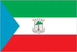
- The national symbols are silk cotton tree; national colors: green, white, red, blue.
- Internet TLD: .gq
Background
Equatorial Guinea gained independence in 1968 after 190 years of Spanish rule. It is one of the smallest countries in Africa, consisting of a mainland territory and five inhabited islands. The capital of Malabo is located on the island of Bioko, approximately 25 km from the Cameroonian coastline in the Gulf of Guinea. Between 1968 and 1979, autocratic President Francisco MACIAS NGUEMA virtually destroyed all of the country’s political, economic, and social institutions before being deposed by his nephew Teodoro OBIANG NGUEMA MBASOGO in a coup. President OBIANG has ruled since October 1979. He has been elected several times since 1996 and was most recently reelected in 2016. Although nominally a constitutional democracy since 1991, presidential and legislative elections since 1996 have generally been labeled as flawed. The president exerts total control over the political system and has placed legal and bureaucratic barriers that hinder political opposition.
Equatorial Guinea experienced rapid economic growth in the early 21st century due to the discovery of large offshore oil reserves in 1996. Production peaked in late 2004 and has slowly declined since, although aggressive searches for new oil fields continue. Despite the country’s economic windfall from oil production, resulting in massive increases in government revenue in past years, the drop in global oil prices as of 2014 has placed significant strain on the state budget and pushed the country into recession. Oil revenues have mainly been used to develop infrastructure, and there have been limited improvements in the population living standards. Equatorial Guinea continues to seek to diversify its economy and increase foreign investment. The country hosts major regional and international conferences and seeks a more significant role in international affairs and leadership in the sub-region.
Geography
The islands are mountainous and volcanic. The mainland is lower, with mangrove swamps along the coast.
Comprising the mainland territory of Río Muni and five islands on the west coast of central Africa, Equatorial Guinea, despite its name, lies just north of the Equator.
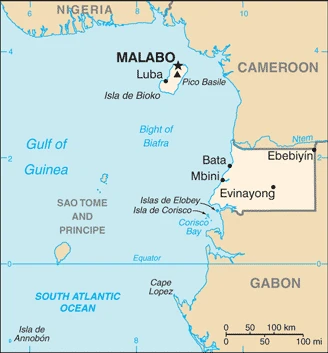
This state is located in Central Africa, bordering the Bight of Biafra, between Cameroon and Gabon, under the coordinates of 2 00 N, 10 00 E, covering an area of 28,051 sq km with a coastline of 296 km. Equatorial Guinea is slightly smaller than Maryland.
Equatorial Guinea has 528 km of land boundaries in total and borders with (2 nations): Cameroon 183 km, Gabon 345 km.
Coastal plains rise to interior hills, islands are volcanic, with Pico Basile 3,008 m as the highest point of Equatorial Guinea, while Atlantic Ocean 0 m as the lowest point, causing a mean elevation at 577 m throughout the country. With a total of 28,051 sq km, Equatorial Guinea has 28,051 sq km of land and 0 sq km water surface area.
Insular and continental regions are widely separated; despite its name, no part of the Equator passes through Equatorial Guinea; the mainland part of the country is located just north of the Equator.
The climate in Equatorial Guinea is as follows: Tropical, always hot, humid.
When you visit Equatorial Guinea, the natural hazards shall be considered: Violent windstorms; flash floods volcanism: Santa Isabel (3,007 m), which last erupted in 1923, is the country’s only historically active volcano; Santa Isabel, along with two dormant volcanoes, form Bioko island in the gulf of guinea.
The following major health-threatening issues shall be considered when visiting Equatorial Guinea: degree of risk: very high (2020), bacterial and protozoal diarrhea, hepatitis A, typhoid fever, malaria, and dengue fever.
Current environmental issues affecting the Equatorial Guinean or Equatoguinean people: deforestation (forests are threatened by agricultural expansion, fires, and grazing); desertification; water pollution (tap water is non-potable); wildlife preservation.
Google Maps Equatorial Guinea
The capital and other divisions
Capital city: Malabo found under the coordinates 3 45 N, 8 47 E, applying the time zone UTC+1 (6 hours ahead of Washington, DC, during Standard Time), using the following daylight saving time: none.
Malabo, the capital of Equatorial Guinea, maybe one of the fastest growing cities in Africa. Its population has more than doubled in just five years and is expected to reach 479,000 people by 2025.
Equatorial Guinea became independent on 12 October 1968 (from Spain), and its national holiday is Independence Day, 12 October (1968).
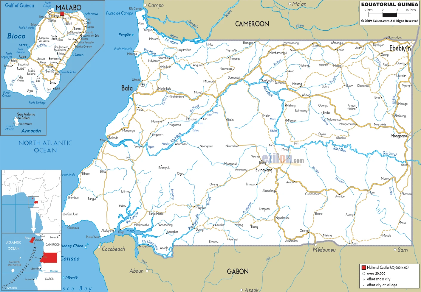
Administrative divisions: 8 provinces (provincias, singular – provincia); Annobon, Bioko Norte, Bioko Sur, Centro Sur, Djibloho, Kie-Ntem, Litoral, Wele-Nzas.
People and society
Equatorial Guinea is the only Spanish-speaking country in Africa. Río Muni is sparsely populated, and most people there are Fang, an ethnic group also found in Cameroon and northern Gabon. Bioco is populated by Bubi and a minority of Creoles known as Fernandinos. Tensions between the two territories have been reignited by discovering oil off Bioco. Wealth is concentrated in the ruling clan; oil revenue since 1995 has made little impact on most people.
The population in Equatorial Guinea is 857,008 (July 2021 estimate), with an average of 2.29% (2021 estimate) change. That means Equatorial Guinea is the No. 165 in the world’s populated rank list. With an average of 20.3 years median age (19.9 years for males and 19.9 years for women), Equatorial Guinea ranks No. 191 on the globe’s median age rank list.
The people living in this country are the Equatorial Guinean(s) or Equatoguinean(s) (noun) or Equatorial Guinean or Equatoguinean (adjective) and belong mainly to the following ethnic groups: Fang 85.7%, Bubi 6.5%, Mdowe 3.6%, Annobon 1.6%, Bujeba 1.1%, other 1.4% (1994 census).
They speak Spanish (official language) 67.6%, other (includes Fang, Bubi, Portuguese (official language), French (official language), Portuguese-based Creoles spoken in Ano Bom) 32.4% (1994 census) languages and practice the following religions: nominally Christian and predominantly Roman Catholic, Muslim, Bahai, animist, indigenous.
We can conclude the following about the population in Equatorial Guinea: Only two large cities over 30,000 people (bata on the mainland, and the capital Malabo on the island of Bioko). As shown in this population distribution map, small communities are scattered throughout the mainland and the five inhabited islands. In Equatorial Guinea, we are talking about 73.6% (2021) of the total population is living in cities, and most of them reside in the following municipalities: 297,000 Malabo (capital city) (2018).
Industry
Oil and gas now account for almost all exports; the government has promised to reinvest oil funds in development. Timber, cocoa, coffee.
The exploitation of oil and gas deposits, beginning in the 1990s, has driven economic growth in Equatorial Guinea; a recent rebasing of GDP resulted in an upward revision of the size of the economy by approximately 30%. Forestry and farming are minor components of GDP. Although pre-independence Equatorial Guinea counted on cocoa production for hard currency earnings, the neglect of the rural economy since independence has diminished the potential for agriculture-led growth. Subsistence farming is the dominant form of livelihood. Declining revenue from hydrocarbon production, high levels of infrastructure expenditures, lack of economic diversification, and corruption have pushed the economy into decline in recent years and limited improvements in the general population’s living conditions. In recent years, Equatorial Guineas’ real GDP growth has been weak, averaging -0.5% per year from 2010 to 2014 because of a declining hydrocarbon sector. Inflation remained very low in 2016, down from an average of 4% in 2014. As a middle-income country, Equatorial Guinea is now ineligible for most low-income World Bank and the IMF funding.
The government has been widely criticized for its lack of transparency and misuse of oil revenues and has attempted to address this issue by complying with the Extractive Industries Transparency Initiative. US foreign assistance to Equatorial Guinea is limited because of US restrictions according to the Trafficking Victims Protection Act. Equatorial Guinea hosted two economic diversification symposia in 2014 that focused on attracting investment in five sectors: agriculture and animal ranching, fishing, mining and petrochemicals, tourism, and financial services. Undeveloped mineral resources include gold, zinc, diamonds, columbite-tantalite, and other base metals. In 2017 Equatorial Guinea signed a preliminary agreement with Ghana to sell liquefied natural gas (LNG); as oil production wanes, the government believes LNG could boost revenues, but it will require significant investments and long lead times to develop.
Equatorial Guinea is rich in the following natural resources: Petroleum, natural gas, timber, gold, bauxite, diamonds, tantalum, sand and gravel, clay.
The main industrial sectors are typically petroleum, natural gas, sawmilling.
The country’s export sectors are particularly strong in crude petroleum, natural gas, industrial alcohols, lumber, veneer sheeting (2019), partnering with these nations: China 34%, India 19%, Spain 11%, United States 7% (2019). The export trade resulted in $8.776 billion. Note: Data are in current year dollars (2019 estimate). In a global rank of the export, values resulted in Equatorial Guinea’s position of 104.
Land use in Equatorial Guinea: 57.5% (2018 estimate) forest, 32.4% (2018 estimate) other.
The arable land area is 4.3% (2018 estimate), and the agricultural land is 10.1% (2018 estimate). Land use for permanent crops 2.1% (2018 estimate), permanent pasture 3.7% (2018 estimate).
The main agro-industrial products of Equatorial Guinea are sweet potatoes, cassava, roots/tubers nes, plantains, oil palm fruit, bananas, coconuts, coffee, cocoa, eggs.
The country typically needs to import: gas turbines, beer, ships, industrial machinery, excavation machinery (2019), partnering with the following nations: the United States 22%, Spain 19%, China 12%, United Kingdom 6%, United Arab Emirates 5% (2019) in a sum value of $6.245 billion (2019 estimate) $6.129 billion (2018 estimate) $5.708 billion (2017 estimate). This sum value on the global ranking list of imports resulted in Equatorial Guinea 129.
Equatorial Guinea Driving Directions
In this post, you learned about Equatorial Guinea, Central Africa, bordering the Bight of Biafra, between Cameroon and Gabon. We published some basic information about its capital Malabo, and the Equatorial Guinean or Equatoguinean nation.
Are you interested in visiting Equatorial Guinea and looking for driving directions? Click here to plan your route, or see a printable road map of Equatorial Guinea below for an overview of the route network.
Printable map of Equatorial Guinea
Did you know about Equatorial Guinea?
Equatorial Guinea’s history and culture are unique. It’s a rare African nation that has never been colonized. Equatorial Guinea was initially a Spanish colony, but it gained its independence in 1968. Equatorial Guinea is the only country in Africa to be named after its location. The name “Equatorial” refers to the Equator – the imaginary line around Earth. The sun passes directly overhead, and day and night are about equal length all year round.
After virtually visiting Equatorial Guinea, you may also be interested in the neighboring countries: Cameroon, Gabon.
If you liked our Google map and Equatorial Guinea information page,
please share it with others or save the link https://www.drivingdirections.net in your bookmarks.