
Gaza Strip Google Maps is a site/tool that offers a wide range of map views (topographic, satellite, street view) and navigation options, with little effort on your part, yet efficiently. If you need to plan a trip to a new place like Gaza Strip, Google maps are available on desktop, mobile, or tablet. This Google maps and information page is dedicated to Gaza Strip, Middle East (19 countries), showing its location, country facts, bordering countries like Egypt Israel, and plenty of other information which may be interesting when you visit this Middle Eastern state.
Quick links: Google Maps Gaza Strip, N/A Google maps, Driving Directions Gaza Strip, Printable Road Map.
About Gaza Strip in a nutshell
- Conventional short form of the name: Gaza Strip
- The conventional long form of the name: none
- Local long form: none
- Local short form: Qita Ghazzah
- Former name(s): N/A
- Etymology: named for the largest city in the region, Gaza, whose settlement can be traced back to at least the 15th century B.C. (as Ghazzat).
- Climate: Temperate, mild winters, dry and warm to hot summers.
- Internet TLD: .ps
Background
Inhabited since at least the 15th century B.C., the Gaza Strip has been dominated by many different peoples and empires throughout its history. It was incorporated into the Ottoman Empire in the early 16th century. The Gaza Strip fell to British forces during World War I, becoming a part of the British Mandate of Palestine. Following the 1948 Arab-Israeli War, Egypt administered the newly formed Gaza Strip. Israel captured it in the Six-Day War in 1967. Under a series of agreements known as the Oslo accords signed between 1993 and 1999, Israel transferred to the newly-created Palestinian Authority (P.A.) security and civilian responsibility for many Palestinian-populated areas of the Gaza Strip and the West Bank. In 2000, a violent intifada or uprising began, and in 2001 negotiations to determine the permanent status of the West Bank and Gaza Strip stalled. Subsequent attempts to re-start negotiations have not progressed toward determining the Israeli-Palestinian conflict’s final status.
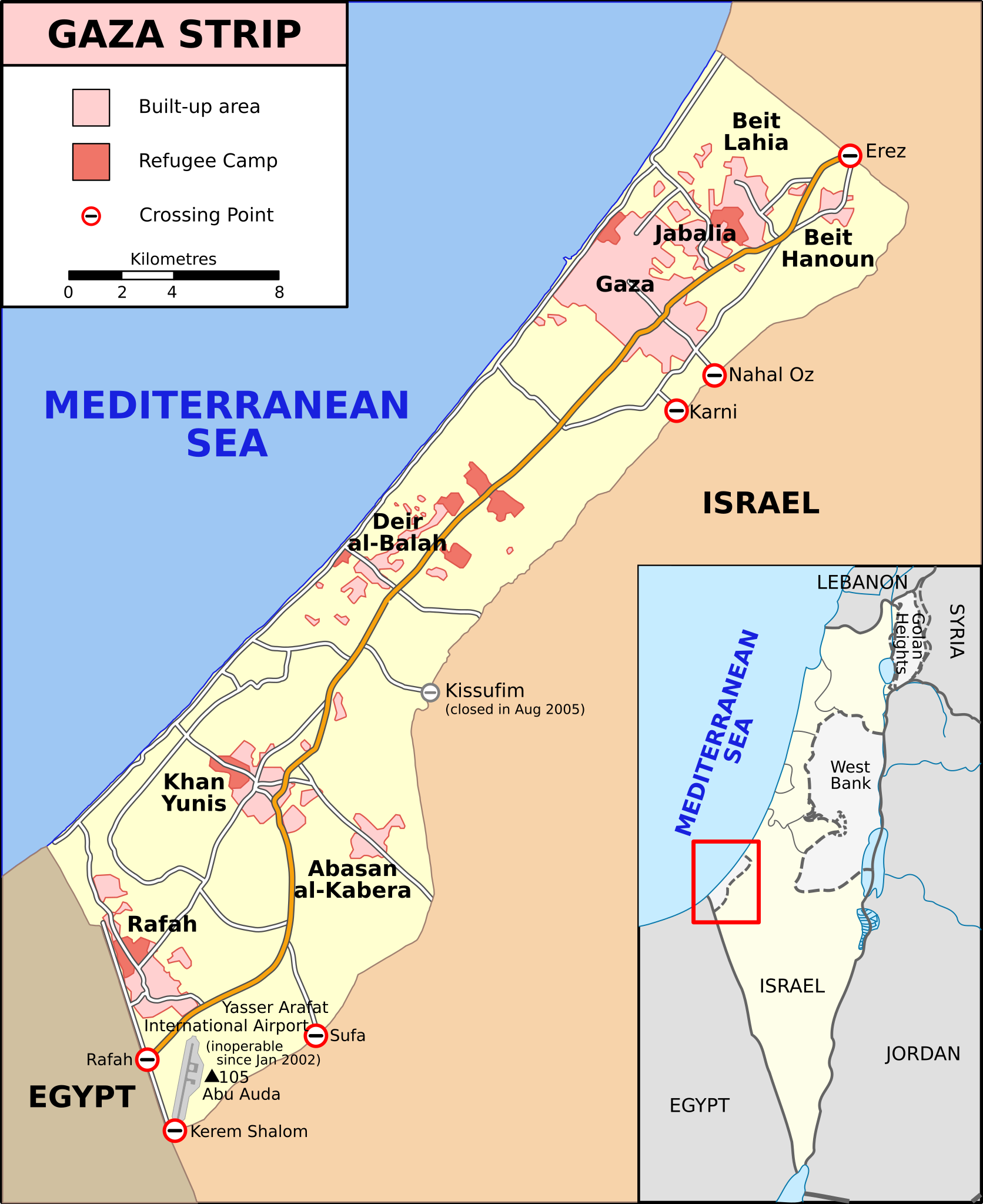
Israel, by late 2005 unilaterally withdrew all of its settlers and soldiers and dismantled its military facilities in the Gaza Strip. Still, it controls the Gaza Strips’ land and maritime borders and airspace. In early 2006, the Islamic Resistance Movement (HAMAS) won a majority in the Palestinian Legislative Council election. Attempts to form a unity government between Fatah, the dominant Palestinian political faction in the West Bank, and HAMAS failed, leading to violent clashes between their respective supporters and HAMASs violent seizure of all military and governmental institutions in the Gaza Strip in June 2007.
Since Hamas’s takeover, Israel and Egypt have enforced tight restrictions on the movement and access of goods and individuals into and out of the territory. Fatah and HAMAS have since reached a series of agreements to restore political unity between the Gaza Strip and the West Bank but have struggled to enact them. A reconciliation agreement signed in October 2017 remains unimplemented.
In July 2014, HAMAS and other Gaza-based militant groups engaged in a 51-day conflict with Israel, culminating in late August with an open-ended truce. Since 2014, Palestinian militants and the Israel Defense Forces have exchanged projectiles and airstrikes, respectively, sometimes lasting multiple days and resulting in multiple deaths on both sides. Egypt, Qatar, and the U.N. Special Coordinator for the Middle East Peace Process have negotiated multiple ceasefires to avert a broader conflict. Since March 2018, HAMAS has coordinated weekly demonstrations along the Gaza security fence, many of which have turned violent, resulting in one Israeli soldier dead and several Israeli soldier injuries, as well as more than 200 Palestinian deaths and thousands of injuries.
Geography
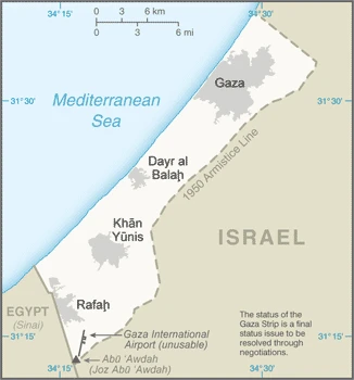
The Gaza Strip is a Palestinian territory southwest of the eastern Mediterranean Sea, bordering Israel and Egypt. The most densely populated region on Earth, with about 1.8 million people living in 221 square kilometers (85 sq mi).
This state is located in the Middle East, bordering the Mediterranean Sea, between Egypt and Israel, under the coordinates of 31 25 N, 34 20 E, covering an area of 360 sq km with a coastline of 40 km. Gaza Strip is Slightly more than twice the size of Washington, DC.
Gaza Strip has 72 km of land boundaries in total, and bordering with (2 nations): Egypt 13 km, Israel 59 km.
Flat to rolling, sand- and dune-covered coastal plain, with Abu Awdah (Joz Abu Awdah) 105 m, as the highest point of Gaza Strip, while the Mediterranean Sea 0 m as the lowest point, causing a mean elevation at 14 meters throughout the country. With a total of 360 sq km, Gaza Strip has 360 sq km of land and 0 sq km water surface area.
A strategic strip of land along Mideast-North African trade routes has experienced an incredibly turbulent history; the town of Gaza itself has been besieged countless times in its history; there are no Israeli settlements in the Gaza Strip; the Gaza Strip settlements were evacuated in 2005.
The climate in Gaza Strip is as follows: Temperate, mild winters, dry and warm to hot summers.
When you visit Gaza Strip, the natural hazards are droughts.
No major health-threatening issues shall be considered when visiting Gaza Strip.
Current environmental issues affecting the people: soil degradation; desertification; water pollution from chemicals and pesticides; salination of freshwater; improper sewage treatment; water-borne disease; depletion and contamination of underground water resources.
Google Maps Gaza Strip
The capital and other divisions
Gaza is the capital of the Palestinian territory of the Gaza Strip. The city was built on an estate belonging to the Al-Sultan family, who built a palace and a mosque in the late 13th century.
People and society
The population in Gaza Strip is 1,957,062 (July 2021 estimate), with an average of 2.05% (2021 estimate) change. That means Gaza Strip is the No. 151 in the world’s populated rank list. With an average of 18 years median age (17.7 years for males and 17.7 years for women), Gaza Strip ranks No. 213 on the globe’s median age rank list.
The people living in this country belong mainly to the following ethnic groups: Palestinian Arabs.
They speak Arabic, Hebrew (spoken by many Palestinians), English (widely understood) languages and practice the following religions: Muslim 98.0 – 99.0% (predominantly Sunni), Christian <1.0%, other, unaffiliated, unspecified <1.0% (2012 estimate) note: the dismantlement of Israeli settlements was completed in September 2005; Gaza has had no Jewish population since then. We can conclude the following about the population in Gaza Strip: Population concentrated in major cities, particularly Gaza city in the north. In Gaza Strip, we are talking about 77% (2021) of the total population is living in cities.
Industry
Movement and access restrictions, violent attacks, and the slow pace of post-conflict reconstruction continue to degrade economic conditions in the Gaza Strip, the smaller of the two areas comprising the Palestinian territories. Israeli controls became more restrictive after HAMAS seized control of the territory in June 2007. Under Hamas control, Gaza has suffered from rising unemployment, elevated poverty rates, and a sharp contraction of the private sector, which had relied primarily on export markets.
Since April 2017, the Palestinian Authority has reduced payments for electricity supplied to Gaza and cut salaries for its employees, exacerbating poor economic conditions. Since 2014, Egypt’s crackdown on the Gaza Strips’ extensive tunnel-based smuggling network has exacerbated fuel, construction material, and consumer goods shortages in the territory. Donor support for reconstruction following the 51-day conflict in 2014 between Israel and HAMAS and other Gaza-based militant groups has fallen short of post-conflict needs.
Gaza Strip is rich in natural resources: Arable land natural gas.
The main industrial sectors are typically textiles, food processing, furniture.
The country’s export sectors are robust in strawberries, carnations, vegetables, and fish (small and irregular shipments permitted to transit the Israeli-controlled Kerem Shalom crossing). The export trade resulted in $1.955 billion. Note: Data are in current year dollars (2017 estimate). In a global rank of the export, values resulted in the Gaza Strip’s position of 153.
The sum of the area of the irrigated land is 240 sq km.
The main agro-industrial products of the Gaza Strip are tomatoes, cucumbers, olives, poultry, milk, potatoes, sheep milk, eggplants, gourds.
The country typically needs to import: food, consumer goods, fuel, in a sum value of $8.59 billion (2018 estimate) $7.852 billion (2017 estimate) see entry for the West Bank. This sum value on the global ranking list of imports resulted in Gaza Strip 115.
Gaza Strip Driving Directions
In this post, you learned about Gaza Strip, the Middle East, bordering the Mediterranean Sea, between Egypt and Israel.
Are you interested in visiting Gaza Strip and looking for driving directions? Click here to plan your route, or see a printable road map of the Gaza Strip below for an overview of the route network.
Printable map of Gaza Strip
Did you know about Gaza Strip?
Gaza Strip is the biggest refugee camp in the Middle East, located along the Mediterranean Sea. It was occupied by Israel since 1967 and has been under blockade ever since. Gaza Strip is known for its high poverty rate, unemployment, and lack of essential services.
After virtually visiting Gaza Strip, you may also be interested in the neighboring countries: Egypt Israel.
If you liked our Google map and the Gaza Strip information page,
please share it with others or save the link https://www.drivingdirections.net in your bookmarks.