
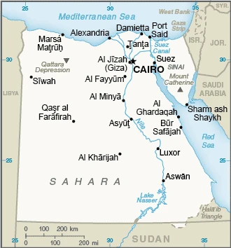
Egypt Google Maps is a site/tool that offers a wide range of map views (topographic, satellite, street view) and navigation options, with little effort on your part, yet efficiently. If you need to plan a trip to a new place like Egypt, Google maps are available on desktop, mobile, or tablet. This Google maps and information page is dedicated to Egypt, Africa (54 countries), showing its location, country facts, details about its capital city Cairo, bordering countries like Gaza Strip, Israel, Libya, Sudan, and plenty of other information which may be interesting when you visit this African state.
Quick links: Google Maps Egypt, Cairo Google maps, Driving Directions Egypt, Printable Road Map.
About Egypt in a nutshell
- In 450 BCE, Herodotus visited the already-ancient pyramids.
- Conventional short form of the name: Egypt
- The conventional long form of the name: Arab Republic of Egypt
- Local long form: Jumhuriyat Misr al-Arabiyah
- Local short form: Misr
- Former name(s): United Arab Republic (with Syria)
- Etymology: the English name Egypt derives from the ancient Greek name for the country Aigyptos; the Arabic name Misr can be traced to the ancient Akkadian misru, meaning border or frontier.
- The legal system in Egypt: a mixed legal system based on Napoleonic civil and penal law, Islamic religious law, and vestiges of colonial-era laws; judicial review of the constitutionality of laws by the Supreme Constitutional Court.
- Climate: Summers are very hot, but winters are cooler. Rainfall is negligible, except on the coast.
- The national symbols are the golden eagle and white lotus; the national colors: are red, white, and black.
- Internet TLD: .eg
90% of Egypt’s population lives in the Nile Valley and Delta, just 3% of the country’s land area. The “gift of the Nile” has always played a key role in world culture, the Islamic world, and world trade since the opening of the Suez Canal. The ancient Egyptians were the first to sail around Africa, the mystery of the source of the world’s most dangerous river inspired the great explorers of Africa in the 19th century, and the opening of the Suez Canal in 1869 opened the way for European ships to East Africa, the Far East, and the Persian Gulf.
European and American ‘explorers’ took all the relics of ancient Egypt – the movable and sometimes even the ‘immovable’ – from the Nile Valley: today, there is hardly a significant museum in the world that does not have an Egyptian collection. Between 1965 and 1968, the construction of the Aswan Dam was not only Africa’s largest reservoir project but also the world’s most significant archaeological rescue operation: monumental ancient monuments in the Upper Nile Valley had to be moved from their original sites to higher ground because of the risk of flooding.
The oldest of Egypt’s World Heritage Sites is not found in the Nile Valley. AI-Hitan Valley, or the Valley of the Whale, is located in the Western Desert. The Archaeoceti, or prehistoric fossils, found here, which are 6-15 million years old, represent an important evolutionary link: they represent a ‘transitional’ state between land and marine mammals. From the 3rd millennium B.C. onwards, the cultural heritage of the Old Kingdom’s capital, Memphis, on the border between Upper and Lower Egypt, opens with the City of the Dead and the pyramids of Giza. Upper Egypt’s Thebes, with its temples at Luxor and Karnak and the Valley of the Kings, is the capital of the Middle and New Kingdoms of the 2nd millennium B.C. In Nubia, the rock temple of Abu Simbel was relocated when the dam was built, and the temples of Philae were built in the 13th century B.C. The buildings of the early Coptic Christian pilgrimage settlement of Abu Mena in the Nile Delta, including the tomb of the holy martyr Alexandrian Menas, are threatened by rising groundwater levels. The World Heritage Site of Cairo, founded in 969 AD, is rounded off by over half a thousand Islamic monuments.
Background
The regularity and richness of the annual Nile River flood, coupled with the semi-isolation provided by deserts to the east and west, allowed for the development of one of the world’s great civilizations. A unified kingdom arose circa 3200 B.C., and a series of dynasties ruled Egypt for the next three millennia. The last native dynasty fell to the Persians in 341 B.C., who was replaced by the Greeks, Romans, and Byzantines. It was the Arabs who introduced Islam and the Arabic language in the 7th century and ruled for the next six centuries. A local military caste, the Mamluks took control about 1250 and continued to govern after the conquest of Egypt by the Ottoman Turks in 1517. Completing the Suez Canal in 1869 elevated Egypt as an important world transportation hub. Ostensibly to protect its investments, Britain seized control of Egypt’s government in 1882, but nominal allegiance to the Ottoman Empire continued until 1914. Partially independent from the U.K. in 1922, Egypt acquired full sovereignty from Britain in 1952. The completion of the Aswan High Dam in 1971 and the resultant Lake Nasser have reaffirmed the Nile River’s time-honored place in Egypt’s agriculture and ecology. A rapidly growing population (the largest in the Arab world), limited arable land, and dependence on the Nile continue to overtax resources and stress society.
The government has struggled to meet the demands of Egypt’s fast-growing population as it implements far-reaching economic reforms, including the reduction of special subsidies, large-scale infrastructure projects, energy cooperation, and foreign direct investment appeals. Inspired by the 2010 Tunisian revolution, Egyptian opposition groups led demonstrations and labor strikes countrywide, culminating in President Hosni Mubarak’s ouster in 2011. Egypt’s military assumed national leadership until a new legislature was established in early 2012. Later that same year, Muhammad MURSI won the presidential election. Following protests throughout the spring of 2013 against Mursi’s government and the Muslim Brotherhood, the Egyptian Armed Forces intervened, removed MURSI from power in July 2013, and replaced him with interim president Adly MANSOUR. Simultaneously, the government began enacting laws limiting freedom of assembly and expression. In January 2014, voters approved a new constitution by referendum and, in May 2014, elected former defense minister Abdelfattah ELSISI president. Egypt elected a new legislature in December 2015, its first House of Representatives since 2012. ELSISI was re-elected to a second four-year term in March 2018.
In April 2019, Egypt approved a set of constitutional amendments extending ELSISI’s term in office through 2024 and possibly through 2030 if re-elected for a third term. The amendments would also allow future presidents up to two consecutive six-year terms in office, re-establish an upper legislative house, allow for one or more vice presidents, establish a 25% quota for female legislators, reaffirm the military’s role as guardian of Egypt, and expand presidential authority to appoint the heads of judicial councils.
Geography
Fertile Nile Valley separates the arid LibyanDesertt from the smaller semiarid Eastern Desert. The Sinai peninsula has mountains in the south.
Egypt is divided by the highly fertile Nile Valley, occupying the northeast corner of Africa. The rise in Islamism has shaken along with ethnic and religious tolerance traditions.
This state is located in Northern Africa, bordering the Mediterranean Sea, between Libya and the Gaza Strip, and the Red Sea north of Sudan, and includes the Asian Sinai Peninsula, under the coordinates of 27 00 N, 30 00 E, covering an area of 1,001,450 sq km with a coastline of 2,450 km. Egypt is More than eight times the size of Ohio; slightly more than three times the size of New Mexico.
Egypt has 2,612 km of land boundaries and borders with (4 nations): Gaza Strip 13 km, Israel 208 km, Libya 1115 km, Sudan 1276 km.
Vast desert plateau interrupted by Nile valley and delta, with Mount Catherine 2,629 m as the highest point of Egypt, while Qattara Depression -133 m as the lowest point, causing a mean elevation at 321 m throughout the country. With 1,001,450 sq km, Egypt has 995,450 sq km of land and a 6,000 sq km water surface area.
Major water bodies in the country: Lake Manzala – 1,360 sq km (saltwater lake), while the significant river is the Nile river mouth (shared with Rwanda, Tanzania, Uganda, South Sudan, and Sudan) – 6,650 km. The significant watersheds for Egypt are the Atlantic Ocean drainage: (Mediterranean Sea) and the Nile (3,254,853 sq km).
Controls the Sinai Peninsula, the only land bridge between Africa and the remainder of the Eastern Hemisphere; controls Suez Canal, a sea link between the Indian Ocean and the Mediterranean Sea; size, and juxtaposition to Israel, establish its central role in Middle Eastern geopolitics; dependence on upstream neighbors; the dominance of Nile basin issues; prone to influxes of refugees from Sudan and the Palestinian territories.
The climate in Egypt is as follows: Desert, hot, dry summers with moderate winters.
When you visit Egypt, the natural hazards shall be considered: Periodic droughts, frequent earthquakes; flash floods; landslides; hot, driving windstorms called khamsin to occur in spring; dust storms, and sandstorms.
The following major health-threatening issues shall be considered when visiting Egypt: degree of risk: intermediate (2020), bacterial diarrhea, hepatitis A, typhoid fever, and schistosomiasis.
Current environmental issues affecting the Egyptian people: agricultural land being lost to urbanization and windblown sands; increasing soil salination below Aswan High Dam; desertification; oil pollution threatening coral reefs, beaches, and marine habitats; other water pollution from agricultural pesticides, raw sewage, and industrial effluents; limited natural freshwater resources away from the Nile, which is the only perennial water source; rapid growth in population overstraining the Nile and natural resources.
Google Maps Egypt
The capital and other divisions
Capital city: Cairo found under the coordinates 30 03 N, 31 15 E, applying the time zone UTC+2 (7 hours ahead of Washington, DC, during Standard Time), using the following daylight saving time: none.
Cairo is a city in Egypt. Some experts believe it’s the oldest city on Earth and pinpointed its ancient origins dating back some 5,000 years ago. The city is not just any old urban center, though, as this UNESCO World Heritage site has something for everyone – from luxury five-star hotels to modern architectural marvels to ancient and fascinating historical landmarks.
Egypt became independent on 28 February 1922 (from U.K. protectorate status; the military-led revolution that began on 23 July 1952 led to a republic being declared on 18 June 1953 and all British troops withdrawn on 18 June 1956); and its national holiday is Revolution Day, 23 July (1952).
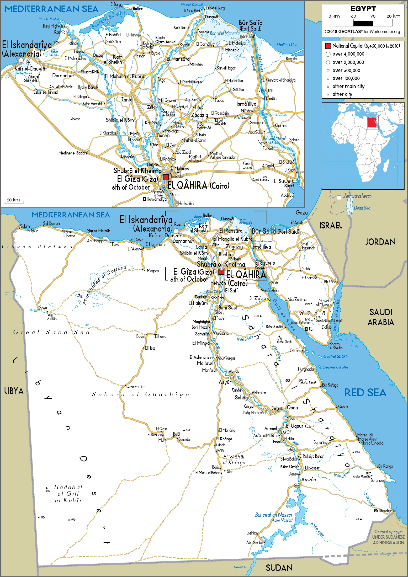
Administrative divisions: 27 governorates (muhafazat, singular – muhafazat); Ad Daqahliyah, Al Bahr al Ahmar (Red Sea), Al Buhayrah, Al Fayyum, Al Gharbiyah, Al Iskandariyah (Alexandria), Al Ismailiyah (Ismailia), Al Jizah (Giza), Al Minufiyah, Al Minya, Al Qahirah (Cairo), Al Qalyubiyah, Al Uqsur (Luxor), Al Wadi al Jadid (New Valley), As Suways (Suez), Ash Sharqiyah, Aswan, Asyut, Bani Suwayf, Bur Said (Port Said), Dumyat (Damietta), Janub Sina (South Sinai), Kafr ash Shaykh, Matruh, Qina, Shamal Sina (North Sinai), Suhaj.
People and society
Mubarak’s military-backed regime was ousted in a popular uprising in the “Arab Spring” of 2011, but the subsequent elected Muslim Brotherhood government was, in turn, ousted. Clashes between Muslims and Copts are rising. Islamism threatens women’s access to education and economic status. Rapidly growing population. Poverty in the south.
The population in Egypt is 106,437,241 (July 2021 estimate), with an average of 2.17% (2021 estimate) change. That means Egypt is the No. 14 in the world’s populated rank list. With an average of 24.1 years median age (23.8 years for males and 23.8 years for women), Egypt ranks No. 166 on the globe’s median age list.
The people living in this country are Egyptian(s) (noun) or Egyptian (adjective) and belong mainly to the following ethnic groups: Egyptian 99.7%, other 0.3% (2006 estimate). Note: data represent respondents by nationality.
They speak Arabic (official language), English, and French, are widely understood by educated classes languages, and practice the following religions: Muslim (predominantly Sunni) 90%, Christian (majority Coptic Orthodox, other Christians include Armenian Apostolic, Catholic, Maronite, Orthodox, and Anglican) 10% (2015 estimate).
We can conclude the following about the population in Egypt: Approximately 95% of the population lives within 20 km of the Nile river and its delta. Vast areas of the country remain sparsely populated or uninhabited, as shown in this population distribution map. In Egypt, we are talking about 42.9% (2021) of the total population living in cities, and most of them reside in the following municipalities: 21.323 million, Cairo (capital city), 5.381 million, and Alexandria (2021).
Industry
Oil and gas. Cotton. Tolls from the Suez Canal. The tourist industry and foreign investment are affected by terrorist attacks and ongoing political instability.
Occupying the northeast corner of the African continent, Egypt is bisected by the highly fertile Nile valley, where most economic activity occurs. Egypt’s economy was highly centralized during the rule of former President Gamal Abdel NASSER but opened up considerably under former Presidents Anwar EL-SADAT and Mohamed Hosni MUBARAK. Agriculture, hydrocarbons, manufacturing, tourism, and other service sectors drove the country’s relatively diverse economic activity.
Despite Egypt’s mixed record for attracting foreign investment over the past two decades, poor living conditions and limited job opportunities have contributed to public discontent. These socioeconomic pressures significantly led to the January 2011 revolution that ousted MUBARAK. The uncertain political, security, and policy environment since 2011 has restricted economic growth and failed to alleviate persistent unemployment, especially among the young. In late 2016, persistent dollar shortages and waning aid from its Gulf allies led Cairo to turn to the IMF for a 3-year, $12 billion loan program. To secure the deal, Cairo floated its currency, introduced new taxes, and cut energy subsidies – all of which pushed inflation above 30% for most of 2017, a high that had not been seen in a generation.
Since the currency float, foreign investment in Egypt’s high-interest treasury bills has risen exponentially, boosting dollar availability and central bank reserves. Cairo will be challenged to obtain foreign and local investment in manufacturing and other sectors without a sustained effort to implement a range of business reforms.
Egypt is rich in the following natural resources: Petroleum, natural gas, iron ore, phosphates, manganese, limestone, gypsum, talc, asbestos, lead, rare earth elements, and zinc.
The main industrial sectors are textiles, food processing, tourism, chemicals, pharmaceuticals, hydrocarbons, construction, cement, metals, and light manufacturers.
The country’s export sectors are robust in crude petroleum, refined petroleum, gold, natural gas, and fertilizers (2019), partnering with these nations: the United States 9%, United Arab Emirates 6%, Italy 6%, Turkey 6%, Saudi Arabia 6%, India 5% (2019). The export trade resulted in $40.1 billion. Note: Data are in current year dollars (2020 estimate). In a global export rank, values resulted in Egypt’s position of 62.
Land use in Egypt: 0.1% (2018 estimate) forest, 96.3% (2018 estimate) other.
The arable land area is 2.8% (2018 estimate), and the agricultural land is 3.6% (2018 estimate). Land use for permanent crops 0.8% (2018 estimate), permanent pasture 0% (2018 estimate). The sum of the area of the irrigated land is 36,500 sq km (2012).
The main agro-industrial products of Egypt are sugar cane, sugar beet, wheat, maize, tomatoes, rice, potatoes, oranges, onions, and milk.
The country typically needs to import: refined petroleum, wheat, crude petroleum, cars, and packaged medicines (2019), partnering with the following nations: China 15%, Russia 7%, United States 6%, Saudi Arabia 6%, Germany 5%, Turkey 5% (2019) in a sum value of $72.48 billion. Note: data are in current year dollars (2020 estimate) $78.95 billion. Note: data are in current year dollars (2019 estimate) $76.33 billion. Note: data are in current year dollars (2018 estimate). This sum value on the global ranking list of imports resulted in Egypt in 47.
Egypt Driving Directions
In this post, you learned about Egypt, and Northern Africa, bordering the Mediterranean Sea, between Libya and the Gaza Strip, the Red Sea north of Sudan, and the Asian Sinai Peninsula. We published some basic information about its capital Cairo, and the Egyptian nation.
Are you interested in visiting Egypt and looking for driving directions? Click here to plan your route, or see a printable road map of Egypt below for an overview of the route network.
Printable map of Egypt
Did you know about Egypt?
The civilization of Ancient Egypt lasted for over three thousand years. It was one of the most influential cultures in history because it gave us many new ideas, inventions, and social norms. For example, they were the first to develop hieroglyphics and had a writing system that anyone could read, no matter their background or language skills. It is filled with rich culture and history, making it an exciting place to visit. The country has many landmarks like the Great Pyramid of Giza and the Nile River, which flows through it. Most of the population is Muslim, but other religions are practiced here. The climate in Egypt tends to be moderate because it is located in the northern region of Africa.
Yet, for all its urban sprawl and 21st-century hustle, Egypt is in many ways still a land of antiquity. The country’s ancient sites – the Pyramids of Giza, the Valley of the Kings, and Abu Simbel – are some of the most iconic and popular tourist destinations on the planet. And while Cairo may be a metropolis in every sense, it’s also home to several traditional Islamic neighborhoods or medinas. In short, Egypt is a country of contradictions: old and new, sacred and secular, East and West. It’s where you can ride a camel through the desert one day and take in a world-class opera performance the next. And it’s this unique blend of cultures and experiences that makes Egypt such an intoxicating destination.
The rest of the country is no less impressive. Egypt has something for everyone: a coastline along the Mediterranean and the Red Sea and desert landscapes that have been used as backdrops in some of Hollywood’s most iconic films. Whether you’re looking to explore ancient ruins or relax on a beach, there’s no shortage of things to do in Egypt. And with discoveries being made, there’s always something new in this ever-changing country.
After virtually visiting Egypt, you may also be interested in the neighboring countries: Gaza Strip, Israel, Libya, Saudi Arabia, and Sudan.
If you liked our Google map and Egypt information page,
please share it with others or save the link https://www.drivingdirections.net in your bookmarks.