
Libya Google Maps is a site/tool that offers a wide range of map views (topographic, satellite, street view) and navigation options, with little effort on your part, yet efficiently. If you need to plan a trip to a new place like Libya, Google maps are available on desktop, mobile, or tablet. This Google maps and information page is dedicated to Libya, Africa (54 countries), showing its location, country facts, details about its capital city Tripoli (Tarabulus), bordering countries like Algeria, Chad, Egypt, Niger, Sudan, Tunisia, and plenty of other information which may be interesting when you visit this African state.
Quick links: Google Maps Libya, Tripoli (Tarabulus) Google maps, Driving Directions Libya, Printable Road Map.
About Libya in a nutshell
- Conventional short form of the name: Libya
- The conventional long form of the name: State of Libya
- Local long form: Dawiat Libiya
- Local short form: Libiya
- Former name(s): N/A
- Etymology: name derives from the Libu, an ancient Libyan tribe first mentioned in texts from the 13th century B.C..
- The legal system in Libya: Libyas post-revolution legal system is in flux and driven by state and non-state entities.
- Climate: Hot and arid. The coastal area has a temperate climate, with mild, wet winters and hot, dry summers.
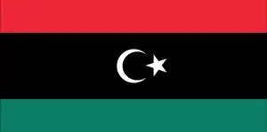
- The national symbols are star and crescent, hawk; national colors: red, black, green.
- Internet TLD: .ly
Libya is the only African country on the Mediterranean coast without a permanent watercourse. 90% of its inhabitants – more than five million Libyans – live in a narrow, fertile coastal plain irrigated by intermittent rainfall. The country is home to the Murzuk sand sea, the largest sand desert in the Sahara. At its edge is the rocky labyrinth of the Acre Mountains, the “twin” of the Algerian Tassili-n’Ajjer: its rock paintings and carvings, dating from 12 000 BC to 100 AD, faithfully reflect the environment of the inhabitants and wildlife of the Sahara after the last ice age. The Phoenician port city of Sabratha, founded in the 8th century BC, was originally a terminus on the Saharan caravan routes, later becoming one of the ‘three cities’ of Tripolis, rebuilt by the Romans in the 2nd and 3rd centuries AD.
Leptis Magna is also one of the “three cities”. Founded by the Phoenicians, it is the best-preserved of the three – the best-preserved Roman monument in the Mediterranean. After the Arab conquest, which began in the 7th century AD, the city was buried in the sands of the desert. Founded in the 7th century BC, Cyrene is a former Greek colony of the Hellenized south coast. Its builders were settlers from the island of Santorini. It fell into Roman hands in the 1st century BC, and its necropolis was buried for another 500 years. The ‘Pearl of the Desert’, the oasis city of Ghadames, founded in the 19th century BC, is one of the oldest Saharan cities and an excellent example of traditional desert architecture. Its houses are on two floors: the lower floor is the storeroom, the upper floor is for family living, the narrow alleys connected to form an almost ‘underground’ network of walkways, and the open terraces of the flat roofs are for women only.
90% of Libya is still desert, despite grand irrigation projects.
Background
Since ancient times, Berbers have inhabited north-central Africa, but the region has been settled and ruled by Phoenicians, Greeks, Carthaginians, Persians, Egyptians, Greeks, Romans, and Vandals. In the 7th century, Islam spread through the region. In the mid-16th century, Ottoman rule began. The Italians supplanted the Ottoman Turks in the area around Tripoli in 1911 and did not relinquish their hold until 1943, when they were defeated in World War II. Libya then passed to the UN administration and achieved independence in 1951. Following a 1969 military coup, Col. Muammar al-QADHAFI assumed leadership and began to espouse his political system at home, a combination of socialism and Islam. During the 1970s, QADHAFI used oil revenues to promote his ideology outside Libya, supporting subversive and terrorist activities that included downing two airliners – one over Scotland, another in Northern Africa – and a discotheque bombing in Berlin. UN sanctions in 1992 isolated QADHAFI politically and economically following the attacks. Sanctions were lifted in 2003 following Libyan acceptance of responsibility for the bombings and agreement to claimant compensation. QADHAFI also agreed to end Libya’s program to develop weapons of mass destruction, and he made significant strides in normalizing relations with Western nations.
The unrest that began in several Middle Eastern and North African countries in late 2010 erupted in Libyan cities in early 2011. Qadhafi’s brutal crackdown on protesters spawned an eight-month civil war that saw UN authorization of air and naval intervention by the international community, the toppling of the QADHAFI regime, and the setting up of a National Transitional Council (NTC). In 2012, the NTC handed power to an elected parliament, the General National Congress (GNC). Voters chose a new parliament to replace the GNC in June 2014 – the House of Representatives (HoR), which relocated to the eastern city of Tobruk after fighting broke out in Tripoli and Benghazi in July 2014.
In December 2015, the UN-brokered an agreement among a broad array of Libyan political parties and social groups – known as the Libyan Political Agreement (LPA). Members of the Libyan Political Dialogue signed the LPA in December 2015. In January 2016, The HoR and defunct-GNC-affiliated political hardliners continued to oppose the GNA and hamper the LPAs implementation. In September 2017, UN Special Representative Ghassan SALAME announced a new roadmap for national political reconciliation. In November 2018, the international partners supported SALAMEs recalibrated Action Plan for Libya that aimed to break the political deadlock by holding a National Conference in early 2019, but attendees failed to reach an agreement. Despite continued clashes since then, the warring parties agreed to an UN-administered ceasefire in October 2020. In early 2021, the UN-led Libyan Political Dialogue Forum selected its executive council’s interim president and prime minister. The council was charged with preparing for December 2021 presidential and parliamentary elections.
Geography
Apart from the coastal strip and a mountain range in the south, Libya is desert or semidesert.
Situated on north Africas Mediterranean coast, Colonel Gaddafi declared Libya a revolutionary state in 1969. The civil war launched in 2011, and Arab Spring ousted his regime.
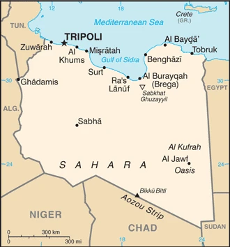
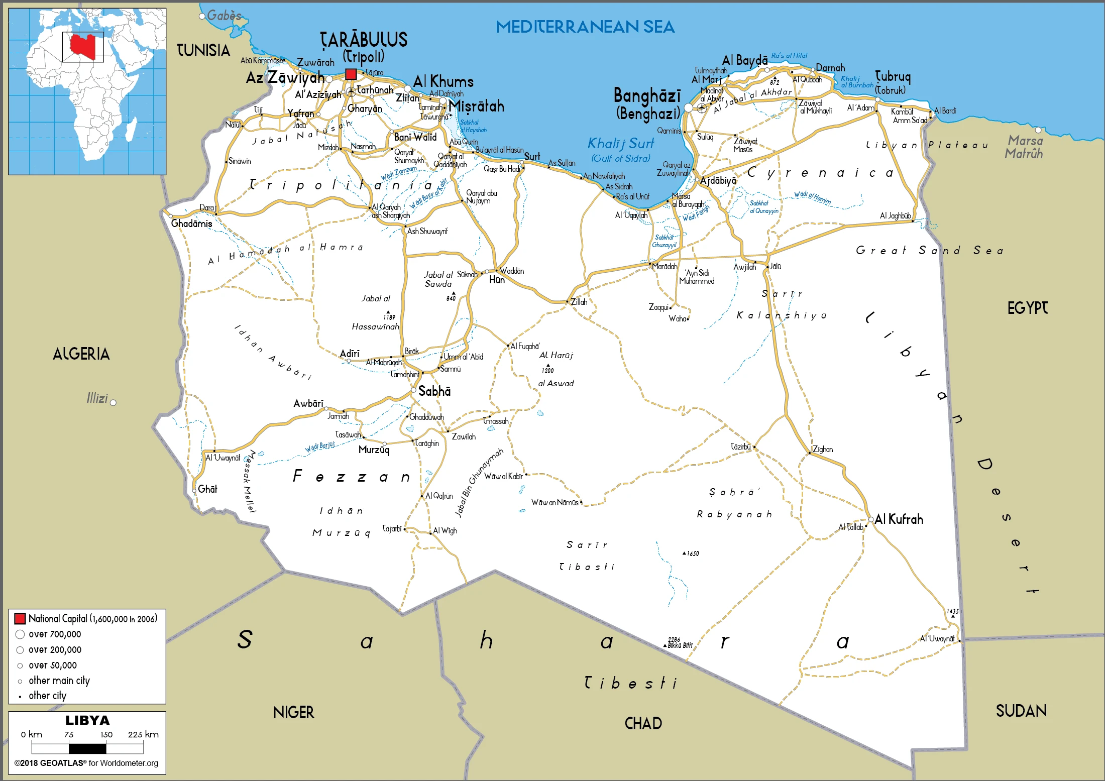
This state is located in Northern Africa, bordering the Mediterranean Sea, between Egypt, Tunisia, and Algeria, under the coordinates of 25 00 N, 17 00 E, covering an area of 1,759,540 sq km with a coastline of 1,770 km. Libya is About 2.5 times the size of Texas, slightly larger than Alaska.
Libya has 4,339 km of land boundaries in total, and bordering with (6 nations): Algeria 989 km, Chad 1050 km, Egypt 1115 km, Niger 342 km, Sudan 382 km, Tunisia 461 km.
Mostly barren, flat to undulating plains, plateaus, depressions, with Bikku Bitti 2,267 m as the highest point of Libya, while Sabkhat Ghuzayyil -47 m as the lowest point, causing a mean elevation at 423 m throughout the country. With a total of 1,759,540 sq km, Libya has 1,759,540 sq km of land and 0 sq km water surface area.
Major water bodies in the country: The significant watersheds for Libya are Internal (endorheic basin) drainage: Lake Chad (2,497,738 sq km).
More than 90% of the country is desert or semidesert.
The climate in Libya is as follows: the Mediterranean along the coast, dry, extreme desert interior.
When you visit Libya, the natural hazards shall be considered: Hot, dry, dust-laden ghibli is a southern wind lasting one to four days in Spring and fall; dust storms, sandstorms.
The following major health-threatening issues shall be considered when visiting Libya: none.
Current environmental issues affecting the Libyan people: desertification; limited natural freshwater resources; the Great Manmade River Project, the largest water development scheme in the world, bring water from large aquifers under the Sahara to coastal cities; water pollution is a significant problem; the combined impact of sewage, oil byproducts, and industrial waste threatens Libya’s coast and the Mediterranean Sea.
Google Maps Libya
The capital and other divisions
Capital city: Tripoli (Tarabulus) found under the coordinates 32 53 N, 13 10 E, applying the time zone UTC+2 (7 hours ahead of Washington, DC, during Standard Time), using the following daylight saving time: none.
Tripoli is the capital of Libya, and it has been described as a beautiful town with several significant landmarks. Its ancient history stretches back to 6000 BC, and it was the seventh-largest city in Africa just before the country gained its independence from Italy in 1951.
Libya became independent on 24 December 1951 (from UN trusteeship), and its national holiday is Liberation Day, 23 October (2011).
Administrative divisions: 22 governorates (muhafazah, singular – muhafazat); Al Butnan, Al Jabal al Akhdar, Al Jabal al Gharbi, Al Jafarah, Al Jufrah, Al Kufrah, Al Marj, Al Marqab, Al Wahat, An Nuqat al Khams, Az Zawiyah, Banghazi (Benghazi), Darnah, Ghat, Misratah, Murzuq, Nalut, Sabha, Surt, Tarabulus (Tripoli), Wadi al Hayat, Wadi ash Shati.
People and society
Once a nation of nomads and livestock herders, it is almost 80% urban. Gaddafi’s revolution wiped out private enterprise and the middle classes and promoted Islam and African unity. Sanctions were lifted after Libya offered compensation for terrorist bombings and ended its Weapons of Mass Destruction (WMD) program. In 2011, rebels from the east took power with international help but failed to unite the country. Tripoli is in the sway of Islamist militias, while rival parliaments vie for political control.
The population in Libya is 7,017,224 (July 2021 estimate). Note: immigrants make up just over 12% of the total population, according to UN data (2019), with an average of 1.76% (2021 estimate) change. That means Libya is the No. 105 in the world’s populated rank list. With an average of 25.8 years median age (25.9 years for males and 25.9 years for women), Libya ranks No. 156 on the globe’s median age rank list.
The people living in this country are the Libyan(s) (noun) or Libyan (adjective) and belong mainly to the following ethnic groups: Berber and Arab 97%, other 3% (includes Egyptian, Greek, Indian, Italian, Maltese, Pakistani, Tunisian, and Turkish).
They speak Arabic (official language), Italian, English (all widely understood in the major cities); Berber (Nafusi, Ghadamis, Suknah, Awjilah, Tamasheq) languages and practice the following religions: Muslim (official; virtually all Sunni) 96.6%, Christian 2.7%, Buddhist 0.3%, Hindu <0.1, Jewish <0.1, folk religion <0.1, unaffiliated 0.2%, other <0.1 (2010 estimate) note: non-Sunni Muslims include native Ibadhi Muslims (<1% of the population) and foreign Muslims. We can conclude the following about the population in Libya: Well over 90% of the population lives along the Mediterranean coast in and between Tripoli to the west and al Bayda to the east. This population distribution map shows that the interior remains vastly underpopulated due to the Sahara and lack of surface water. In Libya, we are talking about 81% (2021) of the total population is living in cities, and most of them reside in the following municipalities: 1.170 million, Tripoli (capital city), 919,000 Misratah, 836,000 Benghazi (2021).
Industry
Oil is vital to export. Dates, olives, and fruit grow in oases, but most food is imported. Recent instability. Corruption and mismanagement.
Libya’s economy, almost entirely dependent on oil and gas exports, has struggled since 2014, given security and political instability, disruptions in oil production, and a decline in global oil prices. The Libyan dinar has lost much of its value since 2014, and the resulting gap between official and black market exchange rates has spurred the growth of a shadow economy and contributed to inflation. The country suffers from widespread power outages caused by fuel shortages for power generation.
Living conditions, including access to clean drinking water, medical services, and safe housing, have declined since 2011. Oil production in 2017 reached a five-year high, driving GDP growth, with average daily production rising to 879,000 barrels per day. However, oil production levels remain below the average pre-Revolution highs of 1.6 million barrels per day., The Central Bank of Libya continued to pay government salaries to a majority of the Libyan workforce and fund subsidies for fuel and food, resulting in an estimated budget deficit of about 17% of GDP in 2017. Low consumer confidence in the banking sector and the economy has driven a severe liquidity shortage.
Libya is rich in the following natural resources: Petroleum, natural gas, gypsum.
The main industrial sectors are petroleum, petrochemicals, aluminum, iron and steel, food processing, textiles, handicrafts, cement.
The country’s export sectors are robust in crude petroleum, natural gas, gold, refined petroleum, scrap iron (2019), partnering with these nations: Italy 18%, China 16%, Germany 15%, Spain 15%, United Arab Emirates 6%, France 6%, United States 5% (2019). The export trade resulted in $29.96 billion. Note: Data are in current year dollars (2018 estimate). In a global rank of the export, values resulted in Libya’s position of 71.
Land use in Libya: 0.1% (2018 estimate) forest, 91.1% (2018 estimate) other.
The arable land area is 1% (2018 estimate), and the agricultural land is 8.8% (2018 estimate). Land use for permanent crops 0.2% (2018 estimate), permanent pasture 7.6% (2018 estimate). The sum of the area of the irrigated land is 4,700 sq km (2012).
The main agro-industrial products of Libya are potatoes, watermelons, tomatoes, onions, dates, milk, olives, wheat, poultry, vegetables.
The country typically needs to import: refined petroleum, cars, broadcasting equipment, cigarettes, jewelry (2019), partnering with the following nations: China 16%, Turkey 14%, Italy 9%, United Arab Emirates 9%, Egypt 5% (2019) in a sum value of $18.85 billion. Note: data are in current year dollars (2018 estimate) $8.667 billion (2016 estimate). This sum value on the global ranking list of imports resulted in Libya 88.
Libya Driving Directions
In this post, you learned about Libya, Northern Africa, bordering the Mediterranean Sea, between Egypt, Tunisia, and Algeria. We published some basic information about its capital Tripoli (Tarabulus), and the Libyan nation.
Are you interested in visiting Libya and looking for driving directions? Click here to plan your route, or see a printable road map of Libya below for an overview of the route network.
Printable map of Libya
Did you know about Libya?
There are many things we don’t know about Libya. One thing is that it is one of the poorest countries in the world. Libya also has a very low GDP per capita because the GDP is primarily composed of oil exports. This country has negligible economic diversification, and it relies heavily on its energy sector. The unemployment rate in Libya is also high, with nearly 18% unemployed.
After virtually visiting Libya, you may also be interested in the neighboring countries: Algeria, Chad, Egypt, Niger, Sudan, Tunisia.
If you liked our Google map and Libya information page,
please share it with others or save the link https://www.drivingdirections.net in your bookmarks.