
Algeria Google Maps is a site/tool that offers a wide range of map views (topographic, satellite, street view) and navigation options, with little effort on your part, yet efficiently. If you need to plan a trip to a new place like Algeria, Google maps are available on desktop, mobile, or tablet. This Google maps and information page is dedicated to Algeria, Africa (54 countries), showing its location, country facts, details about its capital city Algiers, bordering countries like Libya, Mali, Mauritania, Morocco, Niger, Tunisia, and plenty of other information which may be interesting when you visit this African state.
Quick links: Google Maps Algeria, Algiers Google maps, Driving Directions Algeria, Printable Road Map.
About Algeria in a nutshell
- Some of the worlds highest dunes are located in the deserts of east central Algeria.
- Conventional short form of the name: Algeria
- The conventional long form of the name: Peoples Democratic Republic of Algeria
- Local long form: Al Jumhuriyah al Jazairiyah ad Dimuqratiyah ash Shabiyah,
- Local short form: Al Jazair
- Former name(s): N/A
- Etymology: the country name derives from the capital city of Algiers.
- The legal system in Algeria: mixed legal system of French civil law and Islamic law; judicial review of legislative acts in ad hoc Constitutional Council composed of various public officials including several Supreme Court justices.
- Climate: Coastal areas are warm and temperate, with most rainfall during the mild winters. The south is very hot, with negligible rainfall.
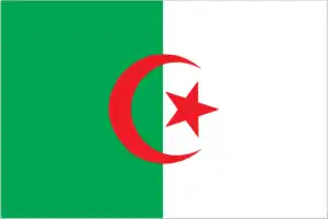
- The national symbols are five-pointed star between the extended horns of a crescent moon, fennec fox; national colors: green, white, red.
- Internet TLD: .dz
The Tassili n’Ajjer massif of the Ahaggar Mountains in the south-eastern tip of Algeria, rising in the lunar landscape of the Sahara, is one of the most important and wealthiest sites of prehistoric cave rock art in the world, with unique geological interest. More than 15 000 rock paintings and engravings depict the animals and the way of life of the peoples of the Sahara, a much wetter place eight millennia ago. Founded by Phoenician traders on the Mediterranean coast, Tipasa was one of the most important early Christian settlements of the ancient ruins during the Roman period and has left its mark on every age.
Jemila, the Roman garrison of Cuicul, was built at 900 m above sea level at the end of the 1st century AD: a fine example of Roman town planning in the mountains. On the northern slope of the Aurès mountains, the military colony of Timgad was founded by the Roman emperor Trajan around 100 AD. Among Algeria’s Islamic monuments, the ruins of the fortress of Hammadida, the first capital of the Hammad dynasty, built in the 11th century and destroyed after 150 years, are a fine example of Muslim fortified cities. The five Berber oasis cities of the Sahara’s M’Zab Valley, built in the 11th century, including Ghardaia, look exactly as they did a millennium ago. The Islamic city of Algiers, Kasbah, was built in the 10th century on a Punic port city site in the 4th century BC.
Background
Algeria has known many empires and dynasties, starting with the ancient Numidians (3rd century BC), Phoenicians, Carthaginians, Romans, Vandals, Byzantines, over a dozen different Arab and Berber dynasties, Spaniards, and Ottoman Turks. Under the latter, the Barbary pirates operated from North Africa. They preyed on shipping beginning in roughly 1500, peaking in the early to mid-17th century, until finally subdued by the French capture of Algiers in 1830. The French southward conquest of the entirety of Algeria proceeded throughout the 19th century and was marked by many atrocities.
The French heavily colonized the country in the late 19th and early 20th centuries. A bloody eight-year struggle culminated in Algerian independence in 1962. Algeria’s primary political party, the National Liberation Front (FLN), was established in 1954 due to independence and primarily dominated politics. The Government of Algeria in 1988 instituted a multi-party system in response to public unrest. Still, the surprising first-round success of the Islamic Salvation Front (FIS) in the December 1991 legislative elections led the Algerian army to intervene and postpone the second round of elections to prevent what the secular elite feared would be an extremist-led government from assuming power. The army began a crackdown on the FIS that spurred FIS supporters to attack government targets. Fighting escalated into an insurgency, which saw intense violence from 1992-98, resulting in over 100,000 deaths – many attributed to indiscriminate massacres of villagers by extremists. The government gained the upper hand by the late-1990s, and FISs armed wing, the Islamic Salvation Army, disbanded in January 2000. With the military’s backing, Abdelaziz BOUTEFLIKA won the presidency in 1999 in an election boycotted by several candidates protesting alleged fraud and won subsequent elections in 2004, 2009, and 2014.
The government in 2011 introduced some political reforms in response to the Arab Spring, including lifting the 19-year-old state of emergency restrictions and increasing women’s quotas for elected assemblies while also increasing subsidies to the populace. Since 2014, Algeria’s reliance on hydrocarbon revenues to fund the government and finance the large subsidies for the population has fallen under stress because of declining oil prices. Protests broke out across the country in late February 2019 against President Bouteflika’s decision to seek a fifth term. BOUTEFLIKA resigned on 2 April 2019, and the speaker of the upper house of parliament, Abdelkader BEN SALAH, became interim head of state on 9 April. BENSALAH remained in office beyond the 90-day constitutional limit until Algerians elected former Prime Minister Abdelmadjid TEBBOUNE as the country’s new president in December 2019.
Geography
85% of the country lies within the Sahara Desert. The fertile coastal region with plains and hills rises to meet the Atlas Mountains.
Since 1962, Algeria has been Africa’s largest country on the Mediterranean coast and independent from France. Its regime used the army to keep Islamists from power in 1992.
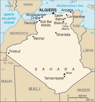
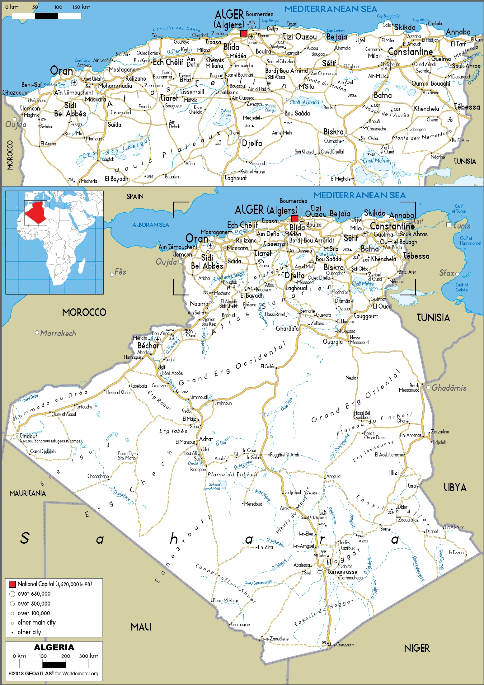
This state is located in Northern Africa, bordering the Mediterranean Sea, between Morocco and Tunisia, under the coordinates of 28 00 N, 3 00 E, covering an area of 2,381,740 sq km with a coastline of 998 km. Algeria is Slightly less than 3.5 times the size of Texas.
Algeria has 6,734 km of land boundaries in total, and bordering with (6 nations): Libya 989 km, Mali 1359 km, Mauritania 460 km, Morocco 1941 km, Niger 951 km, Tunisia 1034 km.
Mostly high plateau and desert, Atlas mountains in the far north and Hoggar mountains in the south, narrow, discontinuous coastal plain, with Tahat 2,908 m as the highest point of Algeria, while Chott Melrhir -40 m as the lowest point, causing a mean elevation at 800 m throughout the country. With a total of 2,381,740 sq km, Algeria has 2,381,740 sq km of land and 0 sq km water surface area.
The significant watersheds for Algeria are Atlantic Ocean drainage: Niger (2,261,741 sq km), Internal (endorheic basin) drainage: Lake Chad (2,497,738 sq km).
The largest country in Africa but 80% desert; canyons and caves in the southern Hoggar Mountains and the barren Tassili n’Ajjer area in the southeast of the country contain numerous examples of prehistoric art-rock paintings and carvings depicting human activities and wild and domestic animals (elephants, giraffes, cattle) – that date to the African Humid Period, roughly 11,000 to 5,000 years ago when the region was utterly vegetated.
The climate in Algeria is as follows: Arid to semiarid, mild, wet winters with hot, dry summers along the coast, drier with cold winters, and hot summers on a high plateau. Sirocco is a hot, dust/sand-laden wind prevalent in summer.
When you visit Algeria, the natural hazards shall be considered: Mountainous areas subject to severe earthquakes; mudslides and floods in the rainy season; droughts.
The following major health-threatening issues shall be considered when visiting Algeria: none.
Current environmental issues affecting the Algerian people: air pollution in major cities; soil erosion from overgrazing and other poor farming practices; desertification; dumping of raw sewage, petroleum refining wastes, and other industrial effluents is leading to the pollution of rivers and coastal waters; the Mediterranean Sea, in particular, becoming polluted from oil wastes, soil erosion, and fertilizer runoff; inadequate supplies of potable water.
Google Maps Algeria
The capital and other divisions
Capital city: Algiers found under the coordinates 36 45 N, 3 03 E, applying the time zone UTC+1 (6 hours ahead of Washington, DC, during Standard Time), using the following daylight saving time: none.
Algiers is a city in Algeria. It is the capital and largest city in the nation. The city’s name comes from the Arabic word for “thieves” or “rogues”.
Algeria became independent on 5 July 1962 (from France), and its national holiday is Independence Day, 5 July (1962); Revolution Day, 1 November (1954).
Administrative divisions: 58 provinces (wilayas, singular – wilaya); Adrar, Ain Defla, Ain Temouchent, Alger, Annaba, Batna, Bechar, Bejaia, Beni Abbes, Biskra, Blida, Bordj Badji Mokhtar, Bordj Bou Arreridj, Bouira, Boumerdes, Chlef, Constantine, Djanet, Djelfa, El Bayadh, El Meghaier, El Meniaa, El Oued, El Tarf, Ghardaia, Guelma, Illizi, In Guezzam, In Salah, Jijel, Khenchela, Laghouat, Mascara, Medea, Mila, Mostaganem, MSila, Naama, Oran, Ouargla, Ouled Djellal, Oum el Bouaghi, Relizane, Saida, Setif, Sidi Bel Abbes, Skikda, Souk Ahras, Tamanrasset, Tebessa, Tiaret, Timimoun, Tindouf, Tipaza, Tissemsilt, Tizi Ouzou, Tlemcen, Touggourt.
People and society
Algerians are predominantly Arab, under 35 years of age, and urban. Berbers consider the mountainous Kabylia region in the northeast to be their homeland. They have been granted greater ethnic rights in recent years. The Sahara sustains 500,000 people, mainly oil workers or Tuareg nomads herding goats and camels. A national reconciliation process has followed the suppression of the Islamist challenge to the regime.
The population in Algeria is 43,576,691 (July 2021 estimate), with an average of 1.41% (2021 estimate) change. That means Algeria is the No. 35 in the world’s populated rank list. With an average of 28.9 years median age (28.6 years for males and 28.6 years for women), Algeria ranks No. 139 on the globe’s median age rank list.
The people living in this country are the Algerian(s) (noun) or Algerian (adjective) and belong mainly to the following ethnic groups: Arab-Berber 99%, European less than 1%. Note: although almost all Algerians are Berber in origin (not Arab), only a minority identify themselves as primarily Berber, about 15% of the total population; these people live mainly in the mountainous region of Kabylie east of Algiers and several other communities; the Berbers are also Muslim but identify with their Berber rather than Arab cultural heritage; Berbers have long agitated, sometimes violently, for autonomy; the government is unlikely to grant autonomy but has officially recognized Berber languages and introduced them into public schools.
They speak Arabic (official language), French (lingua franca), Berber or Tamazight (official language); dialects include Kabyle Berber (Taqbaylit), Shawiya Berber (Tacawit), Mzab Berber, Tuareg Berber (Tamahaq) languages and practice the following religions: Muslim (official; predominantly Sunni) 99%, other (includes Christian, Jewish, Ahmadi Muslims, Shia Muslims, Ibadi Muslims) <1% (2012 estimate). We can conclude the following about the population in Algeria: The vast majority of the populace is found in the extreme northern part of the country along the Mediterranean coast, as shown in this population distribution map. In Algeria, we are talking about 74.3% (2021) of the total population is living in cities, and most of them reside in the following municipalities: 2.809 million, Algiers (capital city), 910,000 Oran (2021).
Industry
Oil and natural gas exports. Political turmoil has led to an exodus of skilled foreign labor. Limited agriculture.
Algeria’s economy remains dominated by the state, a legacy of the country’s socialist post-independence development model. In recent years the Algerian government has halted the privatization of state-owned industries and imposed restrictions on imports and foreign involvement in its economy, pursuing an explicit import substitution policy., Hydrocarbons have long been the backbone of the economy, accounting for roughly 30% of GDP, 60% of budget revenues, and nearly 95% of export earnings. Algeria has the 10th-largest natural gas reserves globally – including the 3rd-largest shale gas reserves – and is the 6th-largest gas exporter. It ranks 16th in proven oil reserves. Hydrocarbon exports enabled Algeria to maintain macroeconomic stability, amass sizeable foreign currency reserves, and maintain low external debt while global oil prices were high. With lower oil prices since 2014, Algeria’s foreign exchange reserves have declined by more than half, and its oil stabilization fund has decreased from about $20 billion at the end of 2013 to about $7 billion in 2017, which is the statutory minimum. Declining oil prices have also reduced the government’s ability to use state-driven growth to distribute rents and fund generous public subsidies. The government has been under pressure to reduce spending.
Over the past three years, the government has enacted incremental increases in some taxes, resulting in modest increases in prices for gasoline, cigarettes, alcohol, and certain imported goods. Still, it has refrained from reducing subsidies, particularly for education, healthcare, and housing programs. Algiers has increased protectionist measures since 2015 to limit its import bill and encourage domestic production of non-oil and gas industries. Since 2015, the government has imposed additional restrictions on access to foreign exchange for imports and import quotas for specific products, such as cars. In January 2018, the government imposed an indefinite suspension on importing roughly 850 products, subject to periodic review. President BOUTEFLIKA announced in fall 2017 that Algeria intends to develop its non-conventional energy resources. Algeria has struggled to develop non-hydrocarbon industries because of heavy regulation and state-driven growth. Algeria has not increased non-hydrocarbon exports, and hydrocarbon exports have declined because of field depletion and increased domestic demand.
Algeria is rich in the following natural resources: Petroleum, natural gas, iron ore, phosphates, uranium, lead, zinc.
The main industrial sectors are typically petroleum, natural gas, light industries, mining, electrical, petrochemical, food processing.
The country’s export sectors are particularly strong in crude petroleum, natural gas, refined petroleum, fertilizers, ammonia (2019), partnering with these nations: Italy 13%, France 13%, Spain 12%, United States 7%, United Kingdom 7%, India 5%, South Korea 5% (2019). The export trade resulted in $38.32 billion. Note: Data are in current year dollars (2019 estimate). In a global rank of the export, values resulted in Algeria’s position of 67.
Land use in Algeria: 0.8% (2018 estimate) forest, 81.8% (2018 estimate) other.
The arable land area is 3.1% (2018 estimate), and the agricultural land is 17.4% (2018 estimate). Land use for permanent crops 0.4% (2018 estimate), permanent pasture 13.8% (2018 estimate). The sum of the area of the irrigated land is 13,600 sq km (2014).
The main agro-industrial products of Algeria are potatoes, wheat, milk, watermelons, barley, onions, tomatoes, oranges, dates, vegetables.
The country typically needs to import: refined petroleum, wheat, packaged medical supplies, milk, vehicle parts (2019), partnering with the following nations: China 18%, France 14%, Italy 8%, Spain 8%, Germany 5%, Turkey 5% (2019) in a sum value of $54.26 billion. Note: data are in current year dollars (2019 estimate) $60.05 billion. Note: data are in current year dollars (2018 estimate). This sum value on the global ranking of imports resulted in Algeria 56.
Algeria Driving Directions
You learned about Algeria, Northern Africa, bordering the Mediterranean Sea, between Morocco and Tunisia in this post. We published some basic information about its capital Algiers, and the Algerian nation.
Are you interested in visiting Algeria and looking for driving directions? Click here to plan your route, or see a printable road map of Algeria below for an overview of the route network.
Printable map of Algeria
Did you know about Algeria?
Algeria is the largest country in North Africa. Its coast on the Mediterranean Sea is slightly longer than its land border of 2,381 kilometers (1,480 miles).
After virtually visiting Algeria, you may also be interested in the neighboring countries: Libya, Mali, Mauritania, Morocco, Niger, Tunisia.
If you liked our Google map and Algeria information page,
please share it with others or save the link https://www.drivingdirections.net in your bookmarks.