
Chad Google Maps is a site/tool that offers a wide range of map views (topographic, satellite, street view) and navigation options, with little effort on your part, yet efficiently. If you need to plan a trip to a new place like Chad, Google maps are available on desktop, mobile, or tablet. This Google maps and information page is dedicated to Chad, Africa (54 countries), showing its location, country facts, details about its capital city N’djamena, bordering countries like Cameroon, Central African Republic, Libya, Niger, Nigeria, Sudan, and plenty of other information which may be interesting when you visit this African state.
Quick links: Google Maps Chad, N’djamena Google maps, Driving Directions Chad, Printable Road Map.
About Chad in a nutshell
- Conventional short form of the name: Chad
- The conventional long form of the name: Republic of Chad
- Local long form: Republique du Tchad / Jumhuriyat Tshad
- Local short form: Tchad / Tshad
- Former name(s): N/A
- Etymology: named for Lake Chad, which lies along the country’s western border; the word tsade means large body of water or lake in several local native languages.
- The legal system in Chad: mixed legal system of civil and customary law.
- Climate: Three distinct zones: desert in north, semiarid region in center, and tropics in south. PEOPLE & SOCIETY
- The national symbols are goat (north), lion (south); national colors: blue, yellow, red.
- Internet TLD: .td
With 200 ethnic groups, 100 languages, three major religions, three climate zones, and a 2500-year history, Chad’s culture is diverse, multifaceted, and complex. In the north, in the Sahara’s heart, live the Berbers’ descendants, the Muslim Tutsis who ruled the country for a quarter of a century. The middle third of the country, the Sahel, is inhabited by the semi-nomadic, pastoral, multi-subgroup Sudanese Arabs, who preserve the Arab musical traditions. The fertile savannahs of the south of the vast country are populated by non-Muslims, mainly agricultural black African ethnic groups. The north-south divide is a constant source of political strife, and the almost total lack of infrastructure discourages even the ‘catastrophe naturists’. The Central African Republic, seven times the size of our country, is a favorite destination for hunting tourists: even elephant hunting is permitted for the big game. The Manovo – Gounda St. Floris National Park in the north of the predominantly forested savannah country, home to the typical savannah wildlife, is on the list of World Heritage in Danger because of illegal grazing and poaching (some estimates suggest that 80% of the park’s wildlife has been poached). The inaccessible tropical rainforest in the south of the country is one of Africa’s best national parks: lucky visitors can track the lowland gorillas with the help of pygmy guides.
Lake Chad is slowly drying up it is now estimated to be just 3% of its size in 1963.
Background
Chad emerged from powerful states that controlled the Sahelian belt starting around the 9th century. These states controlled trans-Saharan trade routes and profited most from the slave trade. The Kanem-Bornu Empire, centered around the Lake Chad Basin, existed between the 9th and 19th centuries. The empire controlled territory stretching from southern Chad to southern Libya and included portions of modern-day Algeria, Cameroon, Nigeria, Niger, and Sudan during its peak.
The Sudanese warlord Rabih AZ-ZUBAYR used an army comprised mainly of enslaved people to conquer the Kanem-Bornu Empire in the late 19th century. In southeastern Chad, the Bagirmi and Ouaddai (Wadai) kingdoms emerged in the 15th and 16th centuries and lasted until the arrival of the French in the 19th and 20th centuries. France began moving into the region in the late 1880s and defeated the Bagirmi kingdom in 1897, Rabih AZ-ZUBAYR in 1900, and the Ouddai kingdom in 1909. In the arid regions of northern Chad and southern Libya, an Islamic order called the Sanusiyya (Sanusi) relied heavily on the trans-Saharan slave trade and had upwards of 3 million followers by the 1880s. The French arrived in the region in the early 1900s and defeated the Sanusiyya in 1910 after years of intermittent war.
By 1910, France had incorporated the northern arid region, the Lake Chad Basin, and southeastern Chad into French Equatorial Africa. Chad achieved its independence in 1960 and saw three decades of instability, oppressive rule, civil war, and a Libyan invasion. With the help of the French military and several African countries, Chadian leaders expelled Libyan forces during the 1987 Toyota War, so named for using Toyota pickup trucks as fighting vehicles. In 1990, Chadian general Idriss DEBY led a rebellion against President Hissene HABRE. Under DEBY, Chad drafted and approved a constitution and held elections in 1996. DEBY won elections in 1996 and 2001. In June 2005, he held a referendum effectively removing constitutional term limits and has been in power. Chad is scheduled to hold a presidential election in April 2021 – Debys 6th term as president if he wins.
Chad faces widespread poverty, an economy severely weakened by low international oil prices, and rebel and terrorist-led insurgencies in the Lake Chad Basin. Additionally, northern Chad has seen several waves of rebellions since 1998. In late 2015, the government imposed a state of emergency in the Lake Chad Basin following multiple attacks by the terrorist group Boko Haram, now known as ISIS-West Africa. In mid-2015, Boko Haram conducted bombings in N’Djamena. In late 2019, the Chadian government also declared a state of emergency in the Sila and Ouaddai regions bordering Sudan and in the Tibesti region bordering Niger, where rival ethnic groups are still fighting. The army has suffered heavy losses to Islamic terror groups in the Lake Chad Basin. In March 2020, ISIS-West Africa fighters attacked a Chadian military camp in the Lake Chad Basin and killed nearly 100 soldiers. It was the deadliest attack in the history of the Chadian military.
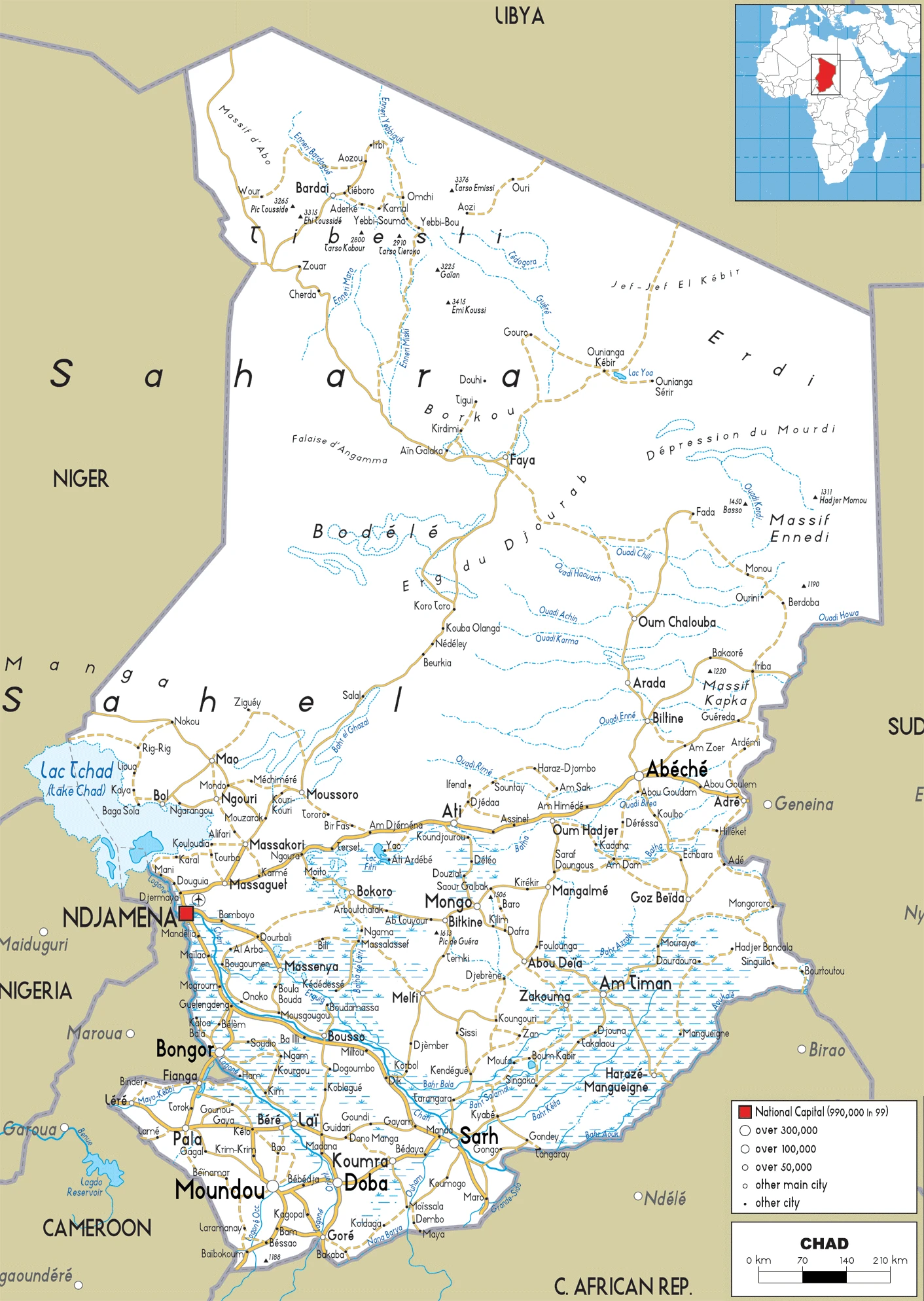
Geography
Most plateaus are sloping westward to Lake Chad. The northern third is Sahara. The Tibesti Mountains in the north rise to 10,826 ft (3300 m).
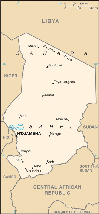
Landlocked in north-central Africa, Chad has had a turbulent history since independence from France in 1960. Intermittent periods of civil war followed a military coup in 1975.
This state is located in Central Africa, south of Libya, under the coordinates of 15 00 N, 19 00 E, covering an area of 1.284 million sq km with a coastline of 0 km (landlocked country). Chad is Almost nine times the size of New York state; slightly more than three times the size of California.
Chad has 6,406 km of land boundaries and borders (6 nations): Cameroon 1116 km, Central African Republic 1556 km, Libya 1050 km, Niger 1196 km, Nigeria 85 km, Sudan 1403 km.
Broad, arid plains in the center, desert in the north, mountains in the northwest, lowlands in the south, with Emi Koussi 3,445 m as the highest point of Chad, while Djourab 160 m as the lowest point, causing a mean elevation at 543 m throughout the country. With a total of 1.284 million sq km, Chad has 1,259,200 sq km of land and 24,800 sq km of water surface area.
Major water bodies in the country: Lake Chad (endorheic lake shared with Niger, Nigeria, and Cameroon) – 10,360-25,900 sq km (a freshwater lake). The significant watersheds for Chad are Atlantic Ocean drainage: Niger (2,261,741 sq km). Internal (endorheic basin) drainage: Lake Chad (2,497,738 sq km).
Chad is the largest of Africa’s 16 landlocked countries.
The climate in Chad is as follows: Tropical in the south, desert in the north.
When you visit Chad, the natural hazards shall be considered: Hot, dry, dusty harmattan winds occur in the north; periodic droughts; locust plagues.
The following major health-threatening issues shall be considered when visiting Chad: degree of risk: very high (2020), bacterial and protozoal diarrhea, hepatitis A and E, typhoid fever, malaria and dengue fever, schistosomiasis, rabies, meningococcal meningitis.
Current environmental issues affecting the Chadian people: inadequate supplies of potable water; improper waste disposal in rural areas, and poor farming practices contribute to soil and water pollution; desertification.
Google Maps Chad
The capital and other divisions
Capital city: N’djamena found under the coordinates 12 06 N, 15 02 E, applying the time zone UTC+1 (6 hours ahead of Washington, DC, during Standard Time), using the following daylight saving time: none.
N’djamena is a city in Chad and the capital of the N’Djamena Region. In 2005, it became the second African city to be included in the “Top 100 Global Cities” list. With an estimated population of over one million, N’djamena is one of the largest cities in Africa.
Chad became independent on 11 August 1960 (from France), and its national holiday is Independence Day, 11 August (1960).
Administrative divisions: 23 provinces (provinces, singular – province); Barh-El-Gazel, Batha, Borkou, Chari-Baguirmi, Ennedi-Est, Ennedi-Ouest, Guera, Hadjer-Lamis, Kanem, Lac, Logone Occidental, Logone Oriental, Mandoul, Mayo-Kebbi-Est, Mayo-Kebbi-Ouest, Moyen-Chari, N’djamena, Ouaddai, Salamat, Sila, Tandjile, Tibesti, Wadi-Fira.
People and society
Half the population lives in Chad’s southern fifth. The northern third has only 100,000 people, mainly Muslim Toubou nomads. Democracy was restored in 1996 by ex-coup leader Idriss Déby, who has won all elections since. Instability has continued, first with the tension between Muslims and southern Christians and, more recently, with rebellions in the east.
The population in Chad is 17,414,108 (July 2021 estimate), with an average of 3.12% (2021 estimate) change. That means Chad is the No. 68 in the world’s populated rank list. With an average of 16.1 years median age (15.6 years for males and 15.6 years for women), Chad ranks No. 223 on the globe’s median age rank list.
The people living in this country are the Chadian(s) (noun) or Chadian (adjective) and belong mainly to the following ethnic groups: Sara (Ngambaye/Sara/Madjingaye/Mbaye) 30.5%, Kanembu/Bornu/Buduma 9.8%, Arab 9.7%, Wadai/Maba/Masalit/Mimi 7%, Gorane 5.8%, Masa/Musseye/Musgum 4.9%, Bulala/Medogo/Kuka 3.7%, Marba/Lele/Mesme 3.5%, Mundang 2.7%, Bidiyo/Migaama/Kenga/Dangleat 2.5%, Dadjo/Kibet/Muro 2.4%, Tupuri/Kera 2%, Gabri/Kabalaye/Nanchere/Somrai 2%, Fulani/Fulbe/Bodore 1.8%, Karo/Zime/Peve 1.3%, Baguirmi/Barma 1.2%, Zaghawa/Bideyat/Kobe 1.1%, Tama/Assongori/Mararit 1.1%, Mesmedje/Massalat/Kadjakse 0.8%, other Chadian ethnicities 3.4%, Chadians of foreign ethnicities 0.9%, foreign nationals 0.3%, unspecified 1.7% (2014-15 estimate).
They speak French (official language), Arabic (official language), Sara (in the south), more than 120 different languages and dialects languages and practice the following religions: Muslim 52.1%, Protestant 23.9%, Roman Catholic 20%, animist 0.3%, other Christian 0.2%, none 2.8%, unspecified 0.7% (2014-15 estimate).
We can conclude the following about the population in Chad: The population is unevenly distributed due to contrasts in climate and physical geography. The highest density is found in the southwest, particularly around lake chad and points south. This population distribution map shows that the dry Saharan zone is the least densely populated to the north. In Chad, we are talking about 23.8% (2021) of the total population is living in cities, and most of them reside in the following municipalities: 1.476 million, N’djamena (capital city) (2021).
Industry
The discovery of oil, and the opening of a pipeline to the coast via Cameroon, are transforming Chads economy, though the new wealth is unlikely to reach most people.
Chads’ landlocked location results in high transportation costs for imported goods and dependence on neighboring countries. Oil and agriculture are the mainstays of Chad’s economy. Oil provides about 60% of export revenues, while cotton, cattle, livestock, and gum arabic provide the bulk of Chad’s non-oil export earnings. The services sector contributes less than one-third of GDP and has attracted foreign investment primarily through telecommunications and banking., Nearly all of Chad’s fuel is provided by one domestic refinery, and unanticipated shutdowns occasionally result in shortages.
The country regulates domestic fuel prices, providing an incentive for black market sales. Although high oil prices and strong local harvests supported the economy, low oil prices now stress Chad’s fiscal position and have resulted in significant government cutbacks. Chad relies on foreign assistance and foreign capital for most public and private sector investments. Investment in Chad is complex due to its limited infrastructure, lack of trained workers, extensive government bureaucracy, and corruption. Chad obtained a three-year extended credit facility from the IMF in 2014 and was granted debt relief under the Heavily Indebted Poor Countries Initiative in April 2015. In 2018, economic policy will be driven by efforts that started in 2016 to reverse the recession and repair damage to public finances and exports. The government implements an emergency action plan to counterbalance the oil revenue drop and diversify the economy.
Chad’s national development plan (NDP) cost just over $9 billion with a financing gap of $6.7 billion. The NDP emphasized the importance of private sector participation in Chad’s development and improving the business environment, particularly in priority sectors such as mining and agriculture. After a long negotiation, the Government of Chad reached a deal with Glencore and four other banks on the restructuring of a $1.45 billion oil-backed loan in February 2018. The new terms include an extension of the maturity to 2030 from 2022, a two-year grace period on principal repayments, and a lower interest rate of the London Inter-bank Offer Rate (Libor) plus 2% – down from Libor plus 7.5%. The original Glencore loan was to be repaid with crude oil assets. However, Chad’s oil sales were hit by the downturn in oil prices. Chad had secured a $312 million credit from the IMF in June 2017, but the release of those funds hinged on restructuring the Glencore debt. Chad had already cut public spending to meet the terms of the IMF program, but that prompted strikes and protests in a country where nearly 40% of the population lives below the poverty line. Multinational partners, such as the African Development Bank, the EU, and the World Bank, will continue budget support in 2018. Still, Chad will remain at high debt risk, given its dependence on oil revenue and pressure to spend on subsidies and security.
Chad is rich in natural resources: Petroleum, uranium, natron, kaolin, fish (lake chad), gold, limestone, sand and gravel, and salt.
The main industrial sectors are oil, cotton textiles, brewing, natron (sodium carbonate), soap, cigarettes, and construction materials.
The country’s export sectors are particularly strong in crude petroleum, gold, livestock, sesame seeds, gum arabic, insect resins (2019), partnering with these nations: China 32%, United Arab Emirates 21%, India 19%, United States 10%, France 6%, Germany 5% (2019). The export trade resulted in $2.464 billion. Note: Data are in current year dollars (2017 estimate). In a global rank of the export, values resulted in Chad’s position of 149.
Land use in Chad: 9.1% (2018 estimate) forest, 51.3% (2018 estimate) other.
The arable land area is 3.9% (2018 estimate), and the agricultural land is 39.6% (2018 estimate). Land use for permanent crops 0% (2018 estimate), permanent pasture 35.7% (2018 estimate). The sum of the area of the irrigated land is 300 sq km (2012).
The main agro-industrial products of Chad are sorghum, groundnuts, millet, yams, cereals, sugar cane, beef, maize, cotton, and cassava.
The country typically needs to import: delivery trucks, paints, packaged medicines, aircraft, broadcasting equipment (2019), partnering with the following nations: China 29%, United Arab Emirates 16%, France 10%, United States 8%, India 5% (2019) in a sum value of $2.16 billion (2017 estimate) $1.997 billion (2016 estimate). This sum value on the global ranking list of imports resulted in Chad 174.
Chad Driving Directions
In this post, you learned about Chad, Central Africa, south of Libya. We published some basic information about its capital N’djamena, and the Chadian nation.
Are you interested in visiting Chad and looking for driving directions? Click here to plan your route, or see a printable road map of Chad below for an overview of the route network.
Printable map of Chad
Did you know about Chad?
After World War II, Chad was converted to a French Overseas Territory. The French wanted to control local resources, from uranium to livestock, for their own needs. It’s one of the poorest countries in the world. Chad is notorious for having terrible weather conditions, food scarcity, and high disease rates.
After virtually visiting Chad, you may also be interested in the neighboring countries: Cameroon, the Central African Republic, Libya, Niger, Nigeria, and Sudan.
If you liked our Google map and Chad information page,
please share it with others or save the link https://www.drivingdirections.net in your bookmarks.