
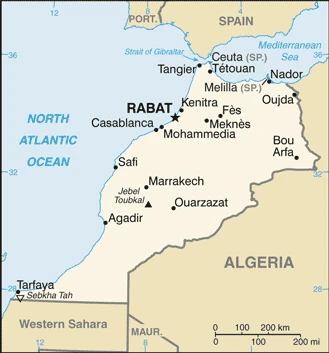
Morocco Google Maps is a site/tool that offers a wide range of map views (topographic, satellite, street view) and navigation options, with little effort on your part, yet efficiently. If you need to plan a trip to a new place like Morocco, Google maps are available on desktop, mobile, or tablet. This Google maps and information page is dedicated to Morocco, Africa (54 countries), showing its location, country facts, details about its capital city Rabat, bordering countries like Algeria, Mauritania, Spain, and plenty of other information which may be interesting when you visit this African state.
Quick links: Google Maps Morocco, Rabat Google maps, Driving Directions Morocco, Printable Road Map.
About Morocco in a nutshell
- Conventional short form of the name: Morocco
- The conventional long form of the name: Kingdom of Morocco
- Local long form: Al Mamlakah al Maghribiyah
- Local short form: Al Maghrib
- Former name(s): French Protectorate in Morocco, Spanish Protectorate in Morocco, Spanish Sahara, Western Sahara
- Etymology: the English name Morocco derives from, respectively, the Spanish and Portuguese names Marruecos and Marrocos, which stem from Marrakesh the Latin name for the former capital of ancient Morocco; the Arabic name Al Maghrib translates as The West.
- The legal system in Morocco: mixed legal system of civil law based on French civil law and Islamic (sharia) law; judicial review of legislative acts by Constitutional Court.
- Climate: Ranges from temperate and warm in the north, to semiarid in the south. Cooler in the mountains.
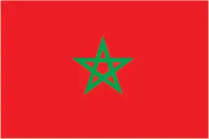
- The national symbols are pentacle symbol, lion; national colors: red, green.
- Internet TLD: .ma
Five times the size of our country, Morocco’s geographical environment is undoubtedly the most diverse of all its North African counterparts. The peaks of the High Atlas, which forms the country’s axis and rises to over 4,000 m, are covered in snow in winter, the limestone slopes of the Rif mountains to the north overlooking the Mediterranean coast are covered with oak forests and vineyards, the fertile plains along the Atlantic in the northwest are irrigated by rivers, and the slopes of the Atlas slope down towards the Sahara in the east and south. The Islamic kingdom’s World Heritage Sites represent almost all the glorious periods of the history of the Maghreb, the north-western part of Africa. Founded by the Carthaginians in the 3rd century BC, the city of Volubilis became the seat of the Roman province of Mauritania in 44 BC. From the 8th century, Tétouan was the main link between Moorish Andalusia and Morocco.
Among the royal cities of central Morocco, Fez, which is also home to the oldest university on earth, flourished in the 13th and 14th centuries. Marrakech, built in the 11th century at the junction of the trans-Saharan caravan, was the capital of several dynasties. The fortress city of Meknes, initially built in the 11th century, flourished in the 17th century during the reign of Sultan Moulay Ismail, when the city, rebuilt in the Spanish-Moorish style, became the capital of the country. On the Atlantic coast, two Portuguese fortified cities, El Jadida (Mazagan), founded in the 16th century, and Essaouira (Magador), founded in the late 18th century, are two of the finest examples of European military architecture and urban planning. The fortress wall of Ait-Ben-Haddou, the ksar, is a surviving example of typical Sahara-Persian architecture from the 16th century.
Karueein University in Fes, founded in 859 CE, is the worlds oldest educational institution.
Background
In 788, about a century after the Arab conquest of North Africa, a series of Moroccan Muslim dynasties began to rule Morocco. In the 16th century, the Saadi monarchy, particularly under Ahmad al-MANSUR (1578-1603), repelled foreign invaders and inaugurated a golden age. The Alaouite Dynasty, to which the current Moroccan royal family belongs, dates from the 17th century. In 1860, Spain occupied northern Morocco and ushered in a half-century of trade rivalry among European powers that steadily eroded Morocco’s sovereignty. In 1912, the French imposed a protectorate over the country. A protracted independence struggle with France ended successfully in 1956. The internationalized city of Tangier and most Spanish possessions were turned over to the new country that same year. Sultan MOHAMMED V, the current monarch’s grandfather, organized the new state as a constitutional monarchy and, in 1957, assumed the title of king. Since Spain’s 1976 withdrawal from what is today called Western Sahara, Morocco has extended its de facto administrative control to roughly 75% of this territory. However, the UN does not recognize Morocco as the administering power for Western Sahara.
The UN, 1991 has, monitored a cease-fire between Morocco and the Polisario Front – an organization advocating the territory’s independence – and restarted negotiations over the territory’s status in December 2018. On 10 December 2020, the US recognized Morocco’s sovereignty over all Western Sahara. King MOHAMMED VI, in early 2011 responded to the spread of pro-democracy protests in the North Africa region by implementing a reform program that included a new constitution, passed by popular referendum in July 2011, under which some new powers were extended to parliament, and the prime minister. Still, ultimate authority remains in the hands of the monarch. In November 2011, the Justice and Development Party (PJD) – a moderate Islamist party – won the most significant seats in parliamentary elections, becoming the first Islamist party to lead the Moroccan Government. In September 2015, Morocco held its first direct elections for regional councils, one of the reforms included in the 2011 constitution. The PJD again won the most significant number of seats in nationwide parliamentary elections in October 2016. In December 2020, Morocco signed a normalization agreement with Israel, similar to that Bahrain, the United Arab Emirates, and Sudan had concluded with Israel earlier in 2020.
Geography
The fertile coastal plain is interrupted in the east by the Rif Mountains. Atlas Mountain ranges to the south. Beyond lies the outer fringe of the Sahara.
Morocco is a former French colony in northwest Africa. Since 1975, it has occupied the territory of Western Sahara, the future of which is yet to be determined by an UN-supervised referendum.
This state is located in Northern Africa, bordering the North Atlantic Ocean and the Mediterranean Sea, between Algeria and Mauritania, under the coordinates of 28 30 N, 10 00 W, covering an area of 716,550 sq km with a coastline of 2,945 km. Morocco is slightly larger than twice the size of California.
Morocco has 3,523.5 km of land boundaries in total and borders (3 nations): Algeria, 1941 km, Mauritania, 1564 km, Spain (Ceuta) 8 km, and Spain (Melilla) 10.5 km.
The mountainous northern coast (Rif mountains) and interior (atlas mountains) are bordered by large plateaus with intermontane valleys and fertile coastal plains. The south is primarily low, flat desert with large areas of rocky or sandy surfaces, with Jebel Toubkal 4,165 m as the highest point of Morocco, while Sebkha Tah -59 m as the lowest point, causing a mean elevation of 909 m throughout the country. With 716,550 sq km, Morocco has 716,300 sq km of land and 250 sq km of water surface area.
The principal river is the Draa – 1,100 km.
Strategic location along the Strait of Gibraltar; the only African nation to have both Atlantic and Mediterranean coastlines; the waters off the Atlantic coast are wealthy fishing areas.
The climate in Morocco is as follows: The Mediterranean in the north, becoming more extreme in the interior, in the south, hot, desert, rain is rare, cold offshore air currents produce fog and heavy dew note: data does not include former western Sahara.
When you visit Morocco, the natural hazards shall be considered: In the north, the mountains are geologically unstable and subject to earthquakes; periodic droughts; windstorms; flash floods; landslides; in the south, a hot, dry, dust/sand-laden sirocco wind can occur during winter and spring; widespread harmattan haze exists 60% of the time, often severely restricting visibility.
The following major health-threatening issues shall be considered when visiting Morocco: none.
Current environmental issues affecting the Moroccan people: in the north, land degradation/desertification (soil erosion resulting from farming of marginal areas, overgrazing, destruction of vegetation); water and soil pollution due to dumping of industrial wastes into the ocean and inland water sources, and onto the land; in the south, desertification; overgrazing; sparse water and lack of arable land note: data does not include former Western Sahara.
Google Maps Morocco
The capital and other divisions
Capital city: Rabat found under the coordinates 34 01 N, 6 49 W, applying the time zone UTC 0 (5 hours ahead of Washington, DC, during Standard Time), using the following daylight saving time: +1 hr, begins last Sunday in March; ends last Sunday in October.
Rabat is the capital of Morocco, located on the Atlantic coast. It was founded in 759 when the Berber tribes from southern Morocco united to resist Arab invaders. The city was called “al-Barayn” before changing its name to Rabat in honor of an early Muslim leader. Rabat has a temperate inland climate with mild summers and cool winters, although the temperature can be high during the summer months. The city’s architecture includes medieval buildings that were reconstructed by later kings and traditional Moroccan homes, mosques, and restaurants.
Morocco became independGovernmentarch 1956 (from France), and its national holiday is Throne Day (accession of King MOHAMMED VI to the throne), 30 July (1999).
Administrative divisions: 12 regions; Beni Mellal-Khenifra, Casablanca-Settat, Dakhla-Oued Ed-Dahab, Draa-Tafilalet, Fes-Meknes, Guelmim-Oued Noun, Laayoune-Sakia El Hamra, Marrakech-Safi, Oriental, Rabat-Sale-Kenitra, Souss-Massa, Tanger-Tetouan-Al Hoceima note: effective 10 December 2020, the US Government recognizes the sovereignty of Morocco over all of the territory of former Western Sahara.
People and society
The Berber minority descend from North Africa’s original inhabitants and live mainly in mountain villages. The Arab majority inhabits the lowlands. Morocco is unusual among Arab states in granting Jews religious freedom and civil rights. The king is a spiritual leader and head of state. During the 2011 “Arab Spring,” protesters called for more democracy. Islamists have gained influence in politics. Islamist militancy and the emergence of terrorist cells are of concern.
The population in Morocco is 36,561,813 (July 2021 estimate). Note: includes Western Sahara, with an average of 0.92% (2021 estimate) change. That means Morocco is the No. 40 in the world’s populated rank list. With an average of 29.1 years median age (28.7 years for males and 28.7 years for women), Morocco ranks No. 137 on the globe’s median age rank list.
The people living in this country are the Moroccan(s) (noun) or Moroccan (adjective) and belong mainly to the following ethnic groups: Arab-Berber 99%, other 1%. Note: This does not include data from the former Western Sahara.
They speak Arabic (official language), Berber languages (Tamazight (official language), Tachelhit, Tarifit), French (often the language of business, government, and diplomacy); languages and practice the following religions: Muslim 99% (official; virtually all Sunni, <0.1% Shia), other 1% (includes Christian, Jewish, and Bahai);. We can conclude the following about the population in Morocco: The highest population density is found along the Atlantic and Mediterranean coasts. As shown in this population distribution map, several densely populated agglomerations are found scattered through the Atlas mountains. In Morocco, we talk about 64.1% (2021) of the total population lives in cities. Most of them reside in the following municipalities: 3.794 million, Casablanca, 1.907 million, Rabat (capital city), 1.245 million, Fes, 1.238 million, Tangier, 1.017 million, Marrakech, 942,000 Agadir (2021).
Industry
Major exporter of phosphates. Investment in tourism and agriculture. Fishing. Relations with the EU strained over illegal immigrants and the cannabis trade.
Morocco has capitalized on its proximity to Europe and relatively low labor costs to work towards building a diverse, open, market-oriented economy. Key sectors of the economy include agriculture, tourism, aerospace, automotive, phosphates, textiles, apparel, and subcomponents. Morocco has increased investment in its port, transportation, and industrial infrastructure to position itself as a center and broker for business throughout Africa. Industrial development strategies and infrastructure improvements – most visibly illustrated by a new port and free trade zone near Tangier – are improving Morocco’s competitiveness., In the 1980s, Morocco was a heavily indebted country before pursuing austerity measures and pro-market reforms overseen by the IMF. Since taking the throne in 1999, King MOHAMMED VI has presided over a stable economy marked by steady growth, low inflation, and gradually falling unemployment. However, poor harvests and economic difficulties in Europe contributed to an economic slowdown. To boost exports, Morocco entered into a bilateral Free Trade Agreement with the US in 2006 and an Advanced Status agreement with the EU in 2008. In late 2014, Morocco eliminated gasoline, diesel, and fuel oil subsidies, dramatically reducing outlays that weighed on the country’s budget and current account. Subsidies on butane gas and certain food products remain in place. Morocco also seeks to expand its renewable energy capacity to make renewable more than 50% of installed electricity generation capacity by 2030. Despite Morocco’s economic progress, the country suffers from high unemployment, poverty, and illiteracy, particularly in rural areas. Key economic challenges for Morocco include reforming the education system and the judiciary.
Morocco is rich in the following natural resources: Phosphates, iron ore, manganese, lead, zinc, fish, salt.
The main industrial sectors are typically automotive parts, phosphate mining and processing, aerospace, food processing, leather goods, textiles, construction, energy, tourism.
The country’s export sectors are robust in cars, insulated wiring, fertilizers, phosphoric acid, clothing, and apparel (2019), partnering with these nations: Spain 23%, France 19% (2019). The export trade resulted in $37.52 billion. Note: Data are in current year dollars (2020 estimate). In a global rank of the export, values resulted in Morocco’s position of 68.
Land use in Morocco: 11.5% (2018 estimate) forest, 21% (2018 estimate) other.
The arable land area is 17.5% (2018 estimate), and the agricultural land is 67.5% (2018 estimate). Land use for permanent crops 2.9% (2018 estimate), permanent pasture 47.1% (2018 estimate). The sum of the area of the irrigated land is 14,850 sq km (2012).
The main agro-industrial products of Morocco are wheat, sugar beet, milk, potatoes, olives, tangerines/mandarins, tomatoes, oranges, barley, onions.
The country typically needs to import: refined petroleum, cars, and vehicle parts, natural gas, coal, low-voltage protection equipment (2019), partnering with the following nations: Spain at 19%, France at 11%, China at 9%, the United States at 7%, Germany 5%, Turkey 5%, Italy 5% (2019) in a sum value of $46.26 billion. Note: data are in current year dollars (2020 estimate) $54.1 billion. Note: data are in current year dollars (2019 estimate) $55.38 billion. Note: data are in current year dollars (2018 estimate). This sum value on the global ranking list of imports resulted in Morocco 63.
Morocco Driving Directions
In this post, you learned about Morocco, Northern Africa, bordering the North Atlantic Ocean and the Mediterranean Sea, between Algeria and Mauritania. We published some basic information about its capital Rabat, and the Moroccan nation.
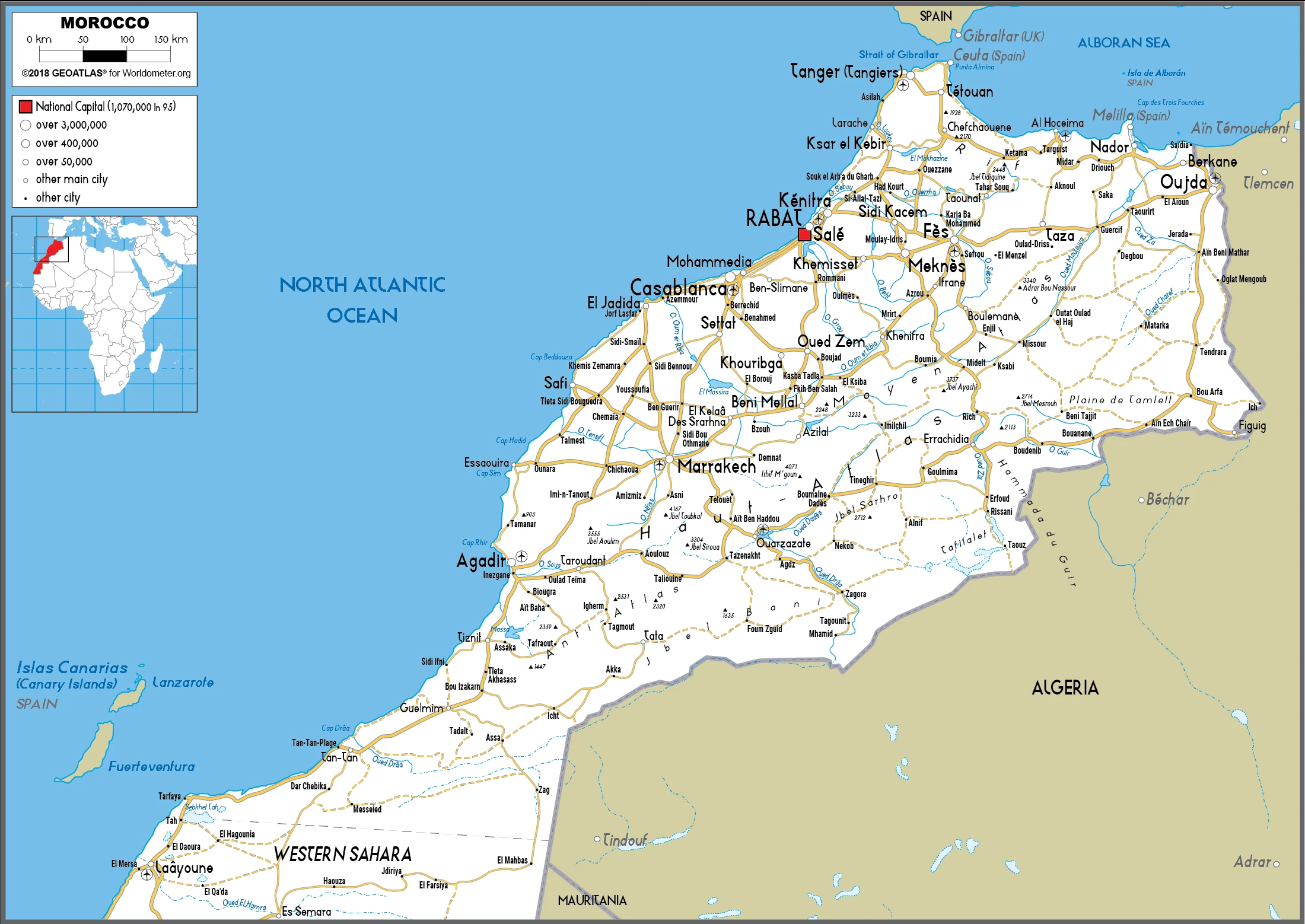
Are you interested in visiting Morocco and looking for driving directions? Click here to plan your route, or see a printable road map of Morocco below for an overview of the route network.
Printable map of Morocco
Did you know about Morocco?
Morocco is a North African country. It is not only the largest country in Africa, but it also has the longest coastline on the African continent. Morocco has one of the most diverse climates in Africa, and its terrain varies from desert to mountain peaks. Morocco’s claims extend to Western Sahara, which is a disputed territory. The country contains many different landscapes, such as the Atlas Mountains and the desert. In addition, Moroccan culture has been heavily influenced by Islam and Arab culture since the eighth century.
One of Morocco’s most famous exports is olives, which make up about 65% of their olive production.
After virtually visiting Morocco, you may also be interested in the neighboring countries: Algeria, Mauritania, Spain.
If you liked our Google map and Morocco information page,
please share it with others or save the link https://www.drivingdirections.net in your bookmarks.