
Liberia Google Maps is a site/tool that offers a wide range of map views (topographic, satellite, street view) and navigation options, with little effort on your part, yet efficiently. If you need to plan a trip to a new place like Liberia, Google maps are available on desktop, mobile, or tablet. This Google maps and information page is dedicated to Liberia, Africa (54 countries), showing its location, country facts, details about its capital city Monrovia, bordering countries like Guinea, Côte d’Ivoire, Sierra Leone, and plenty of other information which may be interesting when you visit this African state.
Quick links: Google Maps Liberia, Monrovia Google maps, Driving Directions Liberia, Printable Road Map.
About Liberia in a nutshell
- Conventional short form of the name: Liberia
- The conventional long form of the name: Republic of Liberia
- Etymology: name derives from the Latin word liber meaning free; so named because the nation was created as a homeland for liberated African-American slaves.
- The legal system in Liberia: mixed legal system of common law, based on Anglo-American law, and customary law.
- Climate: High temperatures. There is only one wet season, from May to October, except in the extreme southeast.
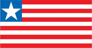
- The national symbols are white star; national colors: red, white, blue.
- Internet TLD: .lr
Liberia, Africa’s first independent state and a republic of formerly enslaved people repatriated from the Americas, has long been in the grip of civil war. A former French colony about the size of Poland, Côte d’Ivoire was a tourist paradise and West Africa’s most popular destination before the current political turmoil and instability. It is home to the most prominent African masked dance festivals, the metropolis of Abidjan, known only as the ‘Paris of West Africa’, and perhaps the world’s most bizarre capital, Yamoussoukro, accessible by an eight-lane highway and boasting a replica of the original St Peter’s Cathedral in Rome rising from the lush rainforest. Côte d’Ivoire’s annual tropical timber production is the equivalent of Brazil’s, which is 20 times larger. The last remaining patch of rainforest in the Tai National Park is internationally protected. The savannah area of Comoé National Park, with its unique plant communities, is the largest game reserve in West Africa, while the Mount Nimba Reserve is a World Heritage Site shared with Guinea.
Liberia is named after the people liberated from slavery who arrived from the US in the 1800s.
Background
With 28 ethnic groups and languages, Liberia is one of the most ethnically diverse countries globally. The Mali and Songhai Empires claimed most of Liberia for hundreds of years. Beginning in the 15th century, European traders began establishing outposts along the Liberian coast. However, unlike its neighbors, Liberia did not fall under European colonial rule. In the early 19th century, the United States began sending freed enslaved people and other people of color to Liberia to establish settlements. In 1847, these settlers declared independence from the United States, writing their constitution and establishing Africa’s first republic. In Liberia’s history, tensions arose between the Americo-Liberian settlers and the indigenous population. In 1980, Samuel DOE, from the indigenous population, led a military coup and ushered in a decade of authoritarian rule. In December 1989, Charles TAYLOR launched a rebellion against the DOEs regime, leading to a prolonged civil war in which the DOE was killed. A period of relative peace in 1997 permitted an election that brought TAYLOR to power. In 2000, fighting resumed. An August 2003 peace agreement ended the war and prompted President Taylor’s resignation. TAYLOR was later convicted by the UN-backed Special Court for Sierra Leone in The Hague for his involvement in Sierra Leone’s civil war. In late 2005, President Ellen JOHNSON SIRLEAF became president after two years of transitional governments. She was the first female head of state in Africa. In 2011, JOHNSON SIRLEAF won reelection but struggled to rebuild Liberia’s economy, particularly following the 2014-15 Ebola epidemic, and reconcile a nation still recovering from 14 years of fighting. In 2017, former soccer star George WEAH won the presidential runoff election.
Geography
A coastline of beaches and mangrove swamps rises to forested plateaus and highlands inland.
LiOnfricas Atlantic coast, Liberia was founded as a republic of formerly enslaved people. A brutal coup in 1980 and years of civil war have left a legacy of gang violence and looting.
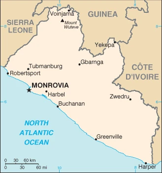
This state is located in Western Africa, bordering the North Atlantic Ocean, between Côte d’Ivoire and Sierra Leone, under the coordinates of 6 30 N, 9 30 W, covering an area of 111,369 sq km with a coastline of 579 km. Liberia is Slightly more significant than Virginia.
Liberia has 1,667 km of land boundaries in total and borders with (3 nations): Guinea 590 km, Côte d’Ivoire 778 km, Sierra Leone 299 km.
Mostly flat to rolling coastal plains rising to rolling plateau and low mountains in the northeast, with Mount Wuteve 1,447 m as the highest point of Liberia, while Atlantic Ocean 0 m as the lowest point, causing a mean elevation at 243 m throughout the country. With a total of 111,369 sq km, Liberia has 96,320 sq km of land and 15,049 sq km water surface area.
Facing the Atlantic Ocean, the coastline is characterized by lagoons, mangrove swamps, and river-deposited sandbars; the inland grassy plateau supports limited agriculture.
The climate in Liberia is as follows: Tropical, hot, humid, dry winters with hot days and cool to cold nights, wet, cloudy summers with frequent heavy showers.
When you visit Liberia, the natural hazards shall be considered: Dust-laden harmattan winds blow from the Sahara (December to March).
The following major health-threatening issues shall be considered when visiting Liberia: degree of risk: very high (2020), bacterial and protozoal diarrhea, hepatitis A, typhoid fever, malaria, dengue fever, yellow fever, schistosomiasis, rabies, Lassa fever.
Current environmental issues affecting the Liberian people: tropical rain forest deforestation; soil erosion; loss of biodiversity; hunting endangered species for bushmeat; pollution of coastal waters from oil residue and raw sewage; pollution of rivers from industrial runoff; burning and dumping of household waste.
Google Maps Liberia
The capital and other divisions
Capital city: Monrovia found under the coordinates 6 18 N, 10 48 W, applying the time zone UTC 0 (5 hours ahead of Washington, DC, during Standard Time), using the following daylight saving time: none.
Monrovia is the capital of Liberia and is located in the Monrovia Canton. It covers a total land area of 125 square miles, with a population of 1,124,000 people. Monrovia was founded in 1822 by formerly enslaved African Americans from the US state of Georgia, who were taken there as part of a resettlement plan to create a colony for freedmen.
Liberia became independent on 26 July 1847, and its national holiday is Independence Day, 26 July (1847).
Administrative divisions: 15 counties; Bomi, Bong, Gbarpolu, Grand Bassa, Grand Cape Mount, Grand Gedeh, Grand Kru, Lofa, Margibi, Maryland, Montserrado, Nimba, River Cess, River Gee, Sinoe.
People and society
The critical social distinction used to be between Americo-Liberians descendants of formerly enslaved people and the indigenous tribal peoples. However, political assimilation and intermarriage have eased tensions. Intertribal tension is now a much more severe problem, fueling the 19902003 civil war. A deadly Ebola outbreak hit the country in 2014.
The population in Liberia is 5,214,030 (July 2021 estimate), with an average of 2.74% (2021 estimate) change. That means Liberia is the No. 123 in the world’s populated rank list. With an average of 18 years median age (17.7 years for males and 17.7 years for women), Liberia ranks No. 215 on the globe’s median age rank list.
The people living in this country are the Liberian(s) (noun) or Liberian (adjective) and belong mainly to the following ethnic groups: Kpelle 20.3%, Bassa 13.4%, Grebo 10%, Gio 8%, Mano 7.9%, Kru 6%, Lorma 5.1%, Kissi 4.8%, Gola 4.4%, Krahn 4%, Vai 4%, Mandingo 3.2%, Gbandi 3%, Mende 1.3%, Sapo 1.3%, other Liberian 1.7%, other African 1.4%, non-African .1% (2008 estimate).
They speak English 20% (official language), some 20 ethnic group languages few of which can be written or used in correspondence languages and practice the following religions: Christian 85.6%, Muslim 12.2%, Traditional 0.6%, other 0.2%, none 1.5% (2008 estimate).
We can conclude the following about the population in Liberia: More than half of the population lives in urban areas, with approximately one-third living within an 80-km radius of Monrovia, as shown in this population distribution map. In Liberia, we are talking about 52.6% (2021) of the total population is living in cities, and most of them reside in the following municipalities: 1.569 million, Monrovia (capital city) (2021).
Industry
War caused the economic collapse. Rubber is vital to export. Bans are now lifted on timber and diamond exports. Revenue from merchant shipping licenses. Debt burden. Vast iron ore reserves. Shutdown in 2014 due to Ebola.
Liberia is a low-income country that relies heavily on foreign assistance and remittances from the diaspora. It is richly endowed with water, mineral resources, forests, and a climate favorable to agriculture. Its principal exports are iron ore, rubber, diamonds, and gold. Palm oil and cocoa are emerging as new export products. The government has attempted to revive raw timber extraction and encourage oil exploration. In the 1990s and early 2000s, civil war and government mismanagement destroyed much of Liberia’s economy, especially infrastructure in and around the capital. Much of the conflict was fueled by control over Liberia’s natural resources. With the conclusion of fighting and installing a democratically elected government in 2006, businesses that had fled the country began to return. The country achieved high growth during 2010-2013 due to favorable world prices for its commodities. However, during the 2014-2015 Ebola crisis, the economy declined, and many foreign-owned businesses departed with their capital and expertise.
The epidemic forced the government to divert scarce resources to combat the spread of the virus, reducing funds available for needed public investment. The cost of addressing the Ebola epidemic coincided with decreased economic activity reducing government revenue, although higher donor support significantly offset this loss. During the same period, global commodities prices for critical exports fell and have yet to recover to pre-Ebola levels. In 2017, gold was a key driver of growth, as a new mining project began its first full year of production; iron ore exports are also increased as Arcelor Mittal opened new mines at Mount Gangra. The completion of the rehabilitation of the Mount Coffee Hydroelectric Dam increased electricity production to support ongoing and future economic activity. However, electricity tariffs remain high relative to other countries in the region, and transmission infrastructure is limited. Presidential and legislative elections in October 2017 generated election-related spending pressures. Revitalizing the economy will depend on economic diversification, increasing investment and trade, higher global commodity prices, sustained foreign aid and remittances, development of infrastructure and institutions, combating corruption, and maintaining political stability and security.
Liberia is rich in the following natural resources: Iron ore, timber, diamonds, gold, hydropower.
The main industrial sectors are typically mining (iron ore and gold), rubber, palm oil, and diamonds.
The country’s export sectors are solid in ships, iron, gold, rubber, crude petroleum (2019), partnering with these nations: Guyana 32%, Poland 10%, Switzerland 8%, Japan 7%, China 5% (2019). The export trade resulted in $550 million. Note: Data are in current year dollars (2019 estimate). In a global rank of the export, values resulted in Liberia’s position of 190.
Land use in Liberia: 44.6% (2018 estimate) forest, 27.3% (2018 estimate) other.
The arable land area is 5.2% (2018 estimate), and the agricultural land is 28.1% (2018 estimate). Land use for permanent crops 2.1% (2018 estimate), permanent pasture 20.8% (2018 estimate). The sum of the area of the irrigated land is 30 sq km (2012).
The main agro-industrial products of Liberia are cassava, sugar cane, oil palm fruit, rice, bananas, vegetables, plantains, rubber, taro, maize.
The country typically needs to import: ships, refined petroleum, iron structures, boat propellers, centrifuges (2019), partnering with the following nations: China 41%, Japan 21%, South Korea 18% (2019) in a sum value of $1.24 billion. Note: data are in current year dollars (2019 estimate) $1.25 billion. Note: data are in current year dollars (2018 estimate) $2.118 billion (2017 estimate). This sum value on the global ranking list of imports resulted in Liberia 184.
Liberia Driving Directions
In this post, you learned about Liberia, Western Africa, bordering the North Atlantic Ocean, between Côte d’Ivoire and Sierra Leone. We published some basic information about its capital Monrovia, and the Liberian nation.
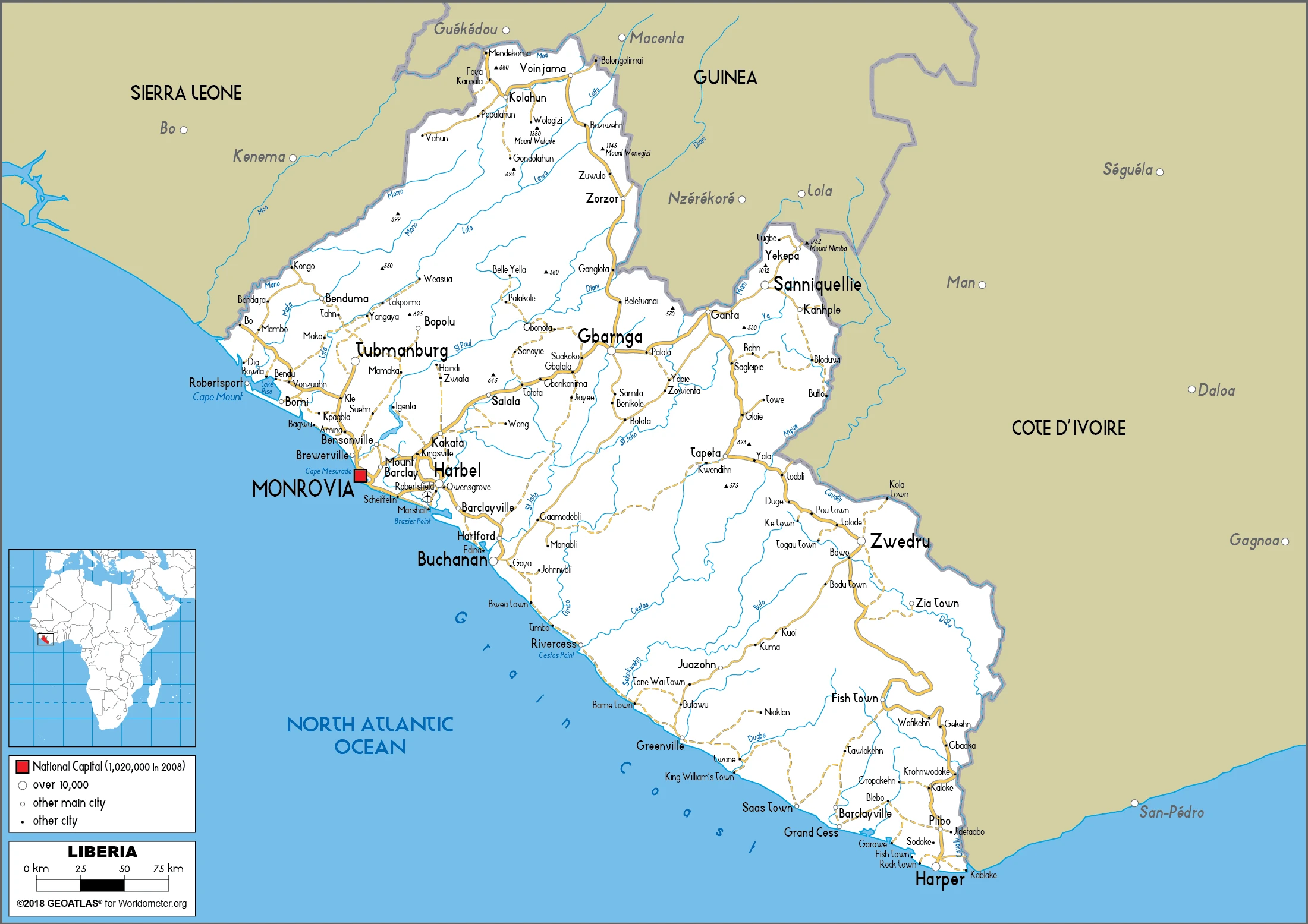
Are you interested in visiting Liberia and looking for driving directions? Click here to plan your route, or see a printable road map of Liberia below for an overview of the route network.
Printable map of Liberia
Did you know about Liberia?
Liberia is the second largest country on the African continent, behind Sudan. Liberia has been through a lot of turmoil, including two civil wars and the Ebola epidemic in 2014. Fortunately, Liberia’s economy is improving, and the country has seen increased tourism. Popular attractions include the Gola Rainforest, Monrovia, and Mount Nimba. It’s also home to some of Africa’s best beaches.
After virtually visiting Liberia, you may also be interested in the neighboring countries: Guinea, Côte d’Ivoire, Sierra Leone.
If you liked our Google map and Liberia information page,
please share it with others or save the link https://www.drivingdirections.net in your bookmarks.