
Côte d’Ivoire Google Maps is a site/tool that offers a wide range of map views (topographic, satellite, street view) and navigation options, with little effort on your part, yet efficiently. If you need to plan a trip to a new place like Côte d’Ivoire, Google maps are available on desktop, mobile, or tablet. This Google maps and information page is dedicated to Côte d’Ivoire, Africa (54 countries), showing its location, country facts, details about its capital city Yamoussoukro (legislative capital), Abidjan (administrative capital), bordering countries like Burkina Faso, Ghana, Guinea, Liberia, Mali, and plenty of other information which may be interesting when you visit this African state.
Quick links: Google Maps Côte d’Ivoire, Yamoussoukro (legislative capital), Abidjan (administrative capital) Google maps, Driving Directions Côte d’Ivoire, Printable Road Map.
About Côte d’Ivoire in a nutshell
- The Basilica of Our Lady of Peace in Yamoussoukro is the largest church in the world.
- Conventional short form of the name: Côte d’Ivoire,
- The conventional long form of the name: Republic of Côte d’Ivoire
- Local long form: Republique de Côte d’Ivoire,
- Local short form: Côte d’Ivoire
- Former name(s): Ivory Coast
- Etymology: name reflects the intense ivory trade that took place in the region from the 15th to 17th centuries.
- The legal system in Côte d’Ivoire: civil law system based on the French civil code; judicial review of legislation held in the Constitutional Chamber of the Supreme Court.
- Climate: Hot all year. Two wet seasons in south; north has one, with lower rainfall.
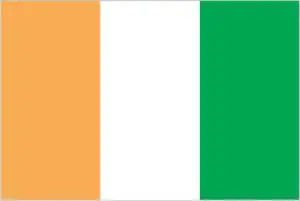
- The national symbols are elephant; national colors: orange, white, green.
- Internet TLD: .ci
A former French colony about the size of Poland, Côte d’Ivoire was a tourist paradise and West Africa’s most popular destination before the current political turmoil and instability. It is home to the most prominent African masked dance festivals, the metropolis of Abidjan, known only as the ‘Paris of West Africa’, and perhaps the world’s most bizarre capital, Yamoussoukro, accessible by an eight-lane highway and boasting a replica of the original St Peter’s Cathedral in Rome rising from the lush rainforest. Côte d’Ivoire’s annual tropical timber production is the equivalent of Brazil’s, which is 20 times larger. The last remaining patch of rainforest in the Taí National Park is internationally protected. The savannah area of Comoé National Park, with its unique plant communities, is the largest game reserve in West Africa, while the Mount Nimba Reserve is a World Heritage Site shared with Guinea.
Background
Various small kingdoms ruled the area of Côte d’Ivoire between the 15th and 19th centuries when European explorers arrived and then began to expand their presence. In 1844, France established a protectorate. Many of these kingdoms and tribes fought to maintain their cultural identities during this period – some well into the 20th century. For example, the Sanwa kingdom – initially founded in the 17th century – tried to break away from Côte d’Ivoire and establish an independent state in 1969. After becoming independent in 1960, Côte d’Ivoire took advantage of close ties with France, cocoa production and export, and foreign investment to become one of the most prosperous states in West Africa.
In December 1999, however, a military coup overthrew the government. In late 2000, junta leader Robert GUEI held rigged elections and declared himself the winner. Widespread protests forced him to step aside, and Laurent GBAGBO was elected. In September 2002, Ivoirian dissidents and military members launched a failed coup that developed into a civil war. In 2003, a cease-fire resulted in rebels holding the north, the government holding the south, and peacekeeping forces occupying a buffer zone in the middle. In March 2007, President GBAGBO and former rebel leader Guillaume SORO signed an agreement in which SORO joined GBAGBOs government as prime minister. The two agreed to reunite the country by dismantling the buffer zone, integrating rebel forces into the national armed forces, and holding elections.
n November 2010, Alassane Dramane OUATTARA won the presidential election, but GBAGBO refused to hand over power, resulting in five months of violent conflict. In April 2011, after widespread fighting, GBAGBO was formally forced from office by armed OUATTARA supporters and UN and French forces. In 2015, OUATTARA won a second term. In October 2020, OUATTARA won a controversial third presidential term, despite a two-term limit in the Ivoirian constitution. In March 2021, the International Criminal Court in The Hague ruled on a final acquittal for GBAGBO, who was on trial for crimes against humanity.
Geography
Sandy coastal strip and rainforested interior, with savanna plateau in the north.
One of the larger nations along the coast of West Africa, Côte d’Ivoire, is the worlds biggest cocoa producer. Since 2002 its image of stability has been rocked by civil war and electoral chaos.
This state is located in Western Africa, bordering the North Atlantic Ocean, between Ghana and Liberia, under the coordinates of 8 00 N, 5 00 W, covering an area of 322,463 sq km with a coastline of 515 km. Côte d’Ivoire is slightly larger than New Mexico.
Côte d’Ivoire has 3,458 km of land boundaries in total, and bordering with (5 nations): Burkina Faso 545 km, Ghana 720 km, Guinea 816 km, Liberia 778 km, Mali 599 km.
Mostly flat to undulating plains, mountains in the northwest, with Monts Nimba 1,752 m as the highest point of Côte d’Ivoire, while Gulf of Guinea 0 m as the lowest point, causing a mean elevation at 250 m throughout the country. With a total of 322,463 sq km, Côte d’Ivoire has 318,003 sq km of land and 4,460 sq km of water surface area.
Major water bodies in the country: no (freshwater lake), Lagune Aby – 780 sq km (saltwater lake), while the major rivers are: none. The significant watersheds for Côte d’Ivoire are Atlantic Ocean drainage: Niger (2,261,741 sq km), Volta (410,991 sq km).
Most inhabitants live along the sandy coastal region; the forested interior is sparsely populated apart from the capital area.
The climate in Côte d’Ivoire is as follows: Tropical along the coast, semiarid in the far north, three seasons – warm and dry (November to March), hot and dry (March to May), hot and wet (June to October).
When you visit Côte d’Ivoire, the natural hazards shall be considered: The coast has heavy surf and no natural harbors; torrential flooding is possible during the rainy season.
The following major health-threatening issues shall be considered when visiting Côte d’Ivoire: degree of risk: very high (2020), bacterial diarrhea, hepatitis A, typhoid fever, malaria, dengue fever, yellow fever, schistosomiasis, rabies, meningococcal meningitis.
Current environmental issues affecting the Ivoirian people: deforestation (most of the country’s forests – once the largest in West Africa – have been heavily logged); water pollution from sewage, industrial, mining, and agricultural effluents.
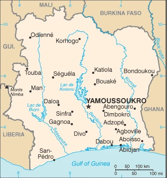
Google Maps Côte d’Ivoire
The capital and other divisions
Capital city: Yamoussoukro (legislative capital), Abidjan (administrative capital) found under the coordinates 6 49 N, 5 16 W, applying the time zone UTC 0 (5 hours ahead of Washington, DC, during Standard Time), using the following daylight saving time: none.
While there is no definite agreement on which country has the legislative capital, Yamoussoukro is the administrative capital of the Ivory Coast. It is also known as “the cockpit of Côte d’Ivoire.”
Côte d’Ivoire became independent on 7 August 1960 (from France), and its national holiday is Independence Day, 7 August (1960).
Administrative divisions: 12 districts and 2 autonomous districts*; Abidjan, Bas-Sassandra, Comoe, Denguele, Goh-Djiboua, Lacs, Lagunes, Montagnes, Sassandra-Marahoue, Savanes, Vallee du Bandama, Woroba, Yamoussoukro, Zanzan.
People and society
Over 60 tribes; the largest is the Baoulé (an Akan group). Southern Christians harbor resentment against non-Ivorian Muslims in the north. Plantations employ millions of migrant workers (including children), though thousands fled to Burkina during the 20022005 civil war. Rebels joined a transitional government in 2007. President Gbagbo delayed elections until 2010 and refused to step down; civil conflict led to his ouster.
The population in Côte d’Ivoire is 28,088,455 (July 2021 estimate). Note: estimates for this country explicitly take into account the effects of excess mortality due to AIDS; this can result in lower life expectancy, higher infant mortality, higher death rates, lower population growth rates, and changes in the distribution of the population by age and sex than would otherwise be expected, with an average of 2.21% (2021 estimate) change. That means Côte d’Ivoire is the No. 52 in the world’s populated rank list. With an average of 20.3 years median age (20.3 years for males and 20.3 years for women), Côte d’Ivoire ranks No. 190 on the globe’s median age rank list.
The people living in this country are the Ivoirian(s) (noun) or Ivoirian (adjective) and belong mainly to the following ethnic groups: Akan 28.9%, Voltaique or Gur 16.1%, Northern Mande 14.5%, Kru 8.5%, Southern Mande 6.9%, unspecified 0.9%, non-Ivoirian 24.2% (2014 estimate).
They speak French (official language), 60 native dialects of which Dioula is the most widely spoken languages and practice the following religions: Muslim 42.9%, Catholic 17.2%, Evangelical 11.8%, Methodist 1.7%, other Christian 3.2%, animist 3.6%, other religion 0.5%, none 19.1% (2014 estimate) note: the majority of foreign migrant workers are Muslim (72.7%) and Christian (17.7%).
We can conclude the following about the population in Côte d’Ivoire: The population is primarily located in the forested south, with the highest concentration of people residing in and around the cities on the Atlantic coast. This population distribution map shows that most northern savanna remains sparsely populated with higher concentrations along transportation corridors. In Côte d’Ivoire, we are talking about 52.2% (2021) of the total population is living in cities, and most of them reside in the following municipalities: 231,000 Yamoussoukro (capital city) (2018), 5.355 million, Abidjan (Seat Of Government) (2021).
Industry
The main crops are cocoa and coffee. Oil is now major export. Good infrastructure. Lack of professional training. Instability deters investment.
For the last 5 years, Côte d’Ivoire’s growth rate has been among the highest in the world. Côte d’Ivoire is heavily dependent on agriculture and related activities, which engage roughly two-thirds of the population. Côte d’Ivoire is the world’s largest producer and exporter of cocoa beans and a significant producer and exporter of coffee and palm oil. Consequently, the economy is susceptible to fluctuations in international prices for these products and climatic conditions. Cocoa, oil, and coffee are the country’s top export revenue earners, but the country has targeted the agricultural processing of cocoa, cashews, mangoes, and other commodities as a high priority. Mining gold and exporting electricity are growing industries outside agriculture., Following the end of more than a decade of civil conflict in 2011, Côte d’Ivoire has experienced a boom in foreign investment and economic growth. In June 2012, the IMF and the World Bank announced $4.4 billion in debt relief for Côte d’Ivoire under the Highly Indebted Poor Countries Initiative.
Côte d’Ivoire is rich in the following natural resources: Petroleum, natural gas, diamonds, manganese, iron ore, cobalt, bauxite, copper, gold, nickel, tantalum, silica sand, clay, cocoa beans, coffee, palm oil, hydropower.
The main industrial sectors are typically foodstuffs, beverages, wood products, oil refining, gold mining, truck and bus assembly, textiles, fertilizer, building materials, electricity.
The country’s export sectors are particularly strong in cocoa beans, gold, rubber, refined petroleum, crude petroleum (2019), partnering with these nations: Netherlands 10%, United States 6%, France 6%, Spain 5%, Malaysia 5%, Switzerland 5%, Germany 5%, Vietnam 5% (2019). The export trade resulted in $13.79 billion. Note: Data are in current year dollars (2019 estimate). In a global export rank, values resulted in Côte d’Ivoire’s position of 95.
Land use in Côte d’Ivoire: 32.7% (2018 estimate) forest, 2.5% (2018 estimate) other.
The arable land area is 9.1% (2018 estimate), and the agricultural land is 64.8% (2018 estimate). Land use for permanent crops 14.2% (2018 estimate), permanent pasture 41.5% (2018 estimate). The sum of the area of the irrigated land is 730 sq km (2012).
The main agro-industrial products of Côte d’Ivoire are yams, cassava, cocoa, oil palm fruit, sugar cane, rice, plantains, maize, cashew nuts, rubber.
The country typically needs to import: crude petroleum, rice, frozen fish, refined petroleum, packaged medicines (2019), partnering with the following nations: China 18%, Nigeria 13%, France 11% (2019) in a sum value of $12.88 billion. Note: data are in current year dollars (2019 estimate) $13.18 billion. Note: data are in current year dollars (2018 estimate). This sum value on the global ranking list of imports resulted in Côte d’Ivoire 98.
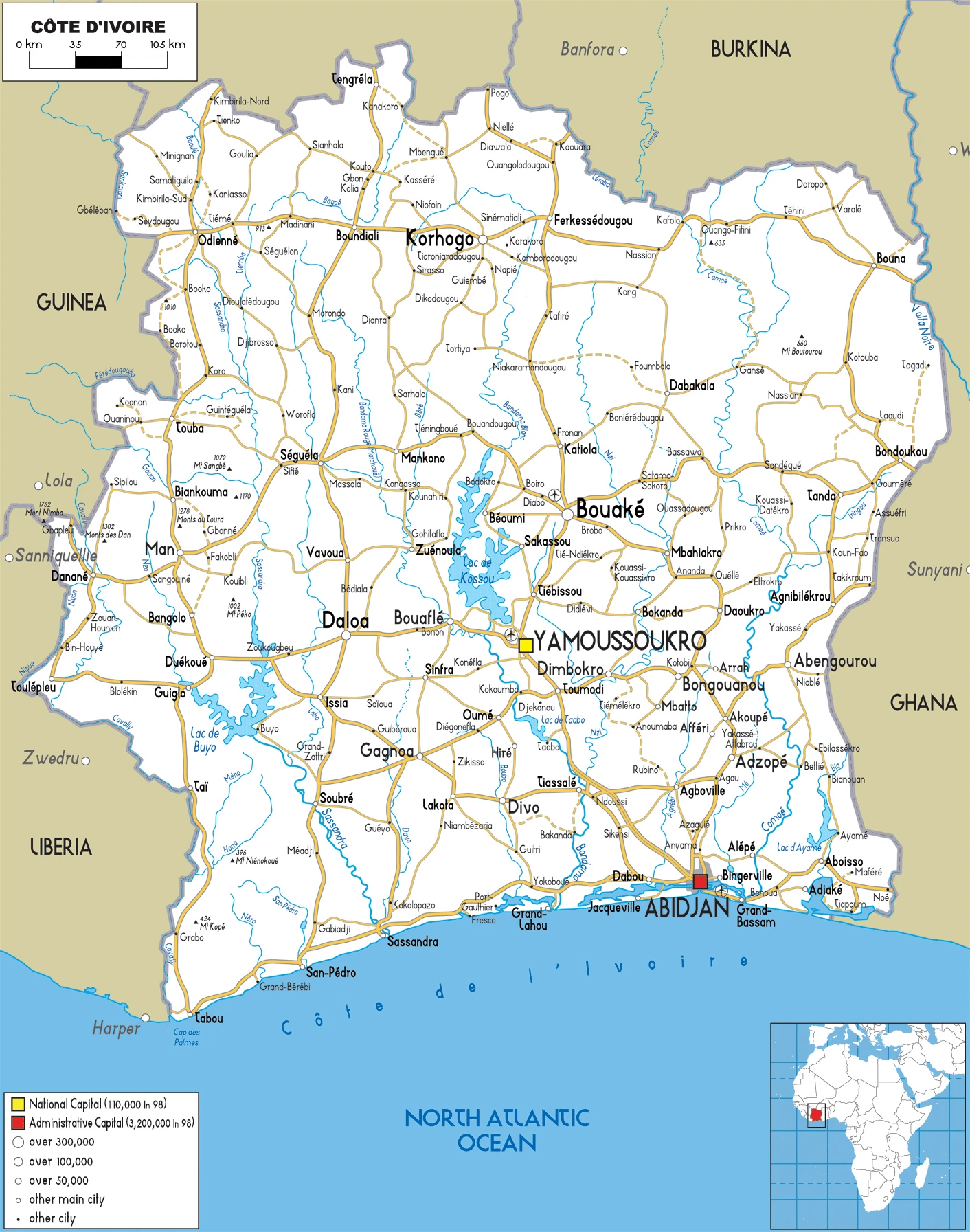
Côte d’Ivoire Driving Directions
In this post, you learned about Côte d’Ivoire, Western Africa, bordering the North Atlantic Ocean, between Ghana and Liberia. We published some basic information about its capital Yamoussoukro (legislative capital), Abidjan (administrative capital), and the Ivoirian nation.
Are you interested in visiting Côte d’Ivoire and looking for driving directions? Click here to plan your route, or see a printable road map of Côte d’Ivoire below for an overview of the route network.
Printable map of Côte d’Ivoire
Did you know about Côte d’Ivoire?
The country of Côte d’Ivoire was once the oldest French colony in Africa, and it became independent in 1960. It is a republic with a multiparty system that has been democratic since 1998. The government has been plagued by corruption, coup attempts, and instability.
Côte d’Ivoire’s coastline is composed mainly of palm tree plantations. Ivory derives from iorh, which means “white” in the ancient Nigerian language.
After virtually visiting Côte d’Ivoire, you may also be interested in the neighboring countries: Burkina Faso, Ghana, Guinea, Liberia, Mali.
If you liked our Google map and Côte d’Ivoire information page,
please share it with others or save the link https://www.drivingdirections.net in your bookmarks.