
Lesotho Google Maps is a site/tool that offers a wide range of map views (topographic, satellite, street view) and navigation options, with little effort on your part, yet efficiently. If you need to plan a trip to a new place like Lesotho, Google maps are available on desktop, mobile, or tablet. This Google maps and information page is dedicated to Lesotho, Africa (54 countries), showing its location, country facts, details about its capital city Maseru, bordering countries like South Africa, and plenty of other information which may be interesting when you visit this African state.
Quick links: Google Maps Lesotho, Maseru Google maps, Driving Directions Lesotho, Printable Road Map.
About Lesotho in a nutshell
- Conventional short form of the name: Lesotho
- The conventional long form of the name: Kingdom of Lesotho
- Local long form: Kingdom of Lesotho
- Local short form: Lesotho
- Former name(s): Basutoland
- Etymology: the name translates as Land of the Sesotho Speakers.
- The legal system in Lesotho: mixed legal system of English common law and Roman-Dutch law; judicial review of legislative acts in High Court and Court of Appeal.
- Climate: Temperate. Summers are hot with torrential rain storms. Snow is frequent in the mountains in winter.
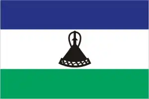
- The national symbols are mokorotio (Basotho hat); national colors: blue, white, green, black.
- Internet TLD: .ls
It is the only country on Earth whose entire territory lies 1000 meters above sea level. The inhabitants of the former Basuto, the Soto, adapted their customs and way of life to the mountainous conditions. The kingdom has been fortunate to have escaped the civil wars, ethnic strife, racist politics, and political instability of recent decades. There is little arable land, and part of the population lives from wool processing or works in neighboring South Africa. Tourism has taken off in the third millennium, with tourist groups from Durban, South Africa, mostly making a one-day visit to the Sani Pass. The capital, Maseru, offers little to see, but Teyateyaneng, the ‘place of quick sand’, is the central market for local artisans. Among the historical monuments, the mountain peak of Thaba-Bosiu, the mountain fortress of Great Moshoeshoe, which united the Sani people in the 19th century, stands out in the truest sense of the word. Mokhotlong, the largest settlement north of Sani Pass, is the coldest, driest, and most remote place.
Lesotho has one of the highest literacy rates in Africa but one of the highest rates of HIV/AIDS too.
Background
Paramount chief MOSHOESHOE I consolidated Basutoland in the early 19th century and made himself king in 1822. Continuing encroachments by Dutch settlers from the neighboring Orange Free State caused the king to enter into an 1868 agreement with the UK. Basutoland became a British protectorate and, after 1884, a crown colony. Upon independence in 1966, the country has renamed the Kingdom of Lesotho. The Basotho National Party ruled the country during its first two decades. King MOSHOESHOE II was exiled in 1990 but returned to Lesotho in 1992 and was reinstated in 1995 and subsequently succeeded by his son, King LETSIE III, in 1996. Constitutional government was restored in 1993 after seven years of military rule.
In 1998, violent protests and a military mutiny following a contentious election prompted a brief but bloody intervention by South African and Botswana military forces under the aegis of the Southern African Development Community. Subsequent constitutional reforms restored relative political stability. Peaceful parliamentary elections were held in 2002, but the National Assembly elections in 2007 were hotly contested. Aggrieved parties disputed how the electoral law was applied to award proportional seats in the Assembly. In 2012, competitive elections involving 18 parties saw Prime Minister Motsoahae Thomas THABANE form a coalition government – the first in the country’s history – that ousted the 14-year incumbent, Pakalitha MOSISILI, who peacefully transferred power the following month. MOSISILI returned to power in snap elections in February 2015 after the collapse of THABANEs’s coalition government and an alleged attempted military coup. In June 2017, THABANE returned to become prime minister.
Geography
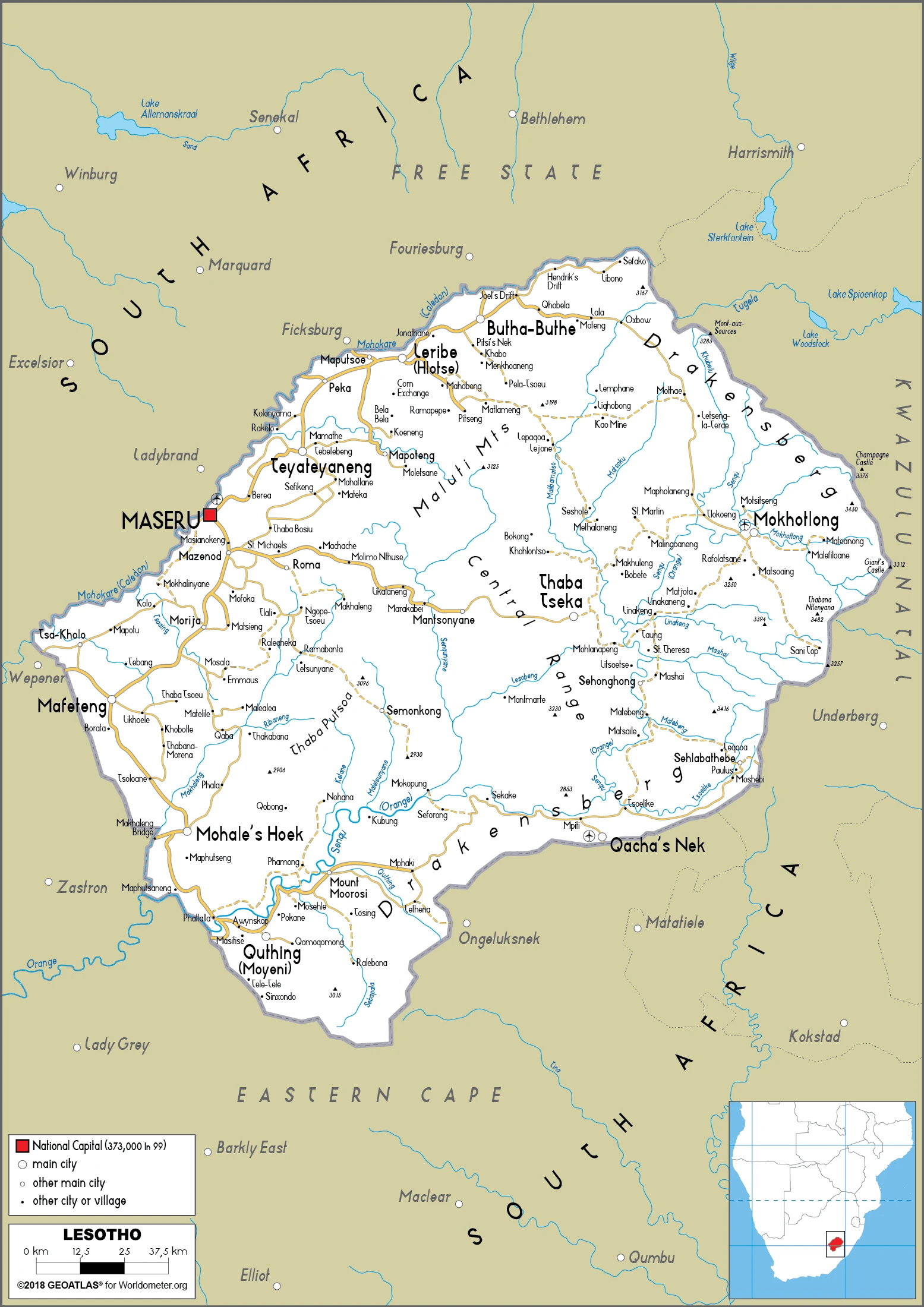
A high mountainous plateau cut by valleys and ravines. The Maluti Range runs through the center. The Drakensberg Range lies to the east.
The landlocked Kingdom of Lesotho is surrounded by and economically dependent on South Africa, which even sent in troops to restore calm after rioting in 1998.
This state is located in Southern Africa, an enclave of South Africa, under the coordinates of 29 30 S, 28 30 E, covering an area of 30,355 sq km with a coastline of 0 km (landlocked country). Lesotho is Slightly smaller than Maryland.
Lesotho has 1,106 km of land boundaries in total and borders with (1 nation): South Africa 1106 km.
Mostly highland with plateaus, hills, and mountains, with Thabana Ntlenyana 3,482 m as the highest point of Lesotho, while junction of the Orange and Makhaleng Rivers 1,400 m as the lowest point, causing a mean elevation at 2,161 m throughout the country. With a total of 30,355 sq km, Lesotho has 30,355 sq km of land and 0 sq km water surface area.
Major water bodies in the country: Orange river source (shared with South Africa and Namibia) – 2,092 km. The significant watersheds for Lesotho are Atlantic Ocean drainage: Orange (941,351 sq km).
Landlocked, an enclave of (surrounded by) South Africa; mountainous, more than 80% of the country is 1,800 m above sea level.
The climate in Lesotho is as follows: Temperate, cool to cold, dry winters, hot, wet summers.
When you visit Lesotho, the natural hazards are periodic droughts.
The following major health-threatening issues shall be considered when visiting Lesotho: degree of risk: intermediate (2020), bacterial diarrhea, hepatitis A, and typhoid fever.
Current environmental issues affecting the Basotho people: population pressure forcing settlement in marginal areas results in overgrazing, severe soil erosion, and soil exhaustion; desertification; Highlands Water Project controls, stores, and redirects water to South Africa.
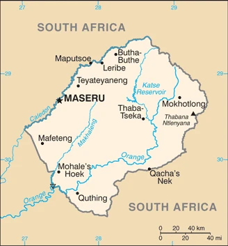
Google Maps Lesotho
The capital and other divisions
Capital city: Maseru found under the coordinates 29 19 S, 27 29 E, applying the time zone UTC+2 (7 hours ahead of Washington, DC, during Standard Time), using the following daylight saving time: none.
Maseru is the capital city of Lesotho. It also serves as the capital of the Maseru District. The area around Maseru is an agricultural region with many flowers, vegetables, and fruits grown by its inhabitants. The city has a large marketplace where people buy their fresh produce. There are also numerous factories in Maseru that produce textiles and other goods.
Lesotho became independent on 4 October 1966 (from the UK), and its national holiday is Independence Day, 4 October (1966).
Administrative divisions: 10 districts; Berea, Butha-Buthe, Leribe, Mafeteng, Maseru, Mohales Hoek, Mokhotlong, Qachas Nek, Quthing, Thaba-Tseka.
People and society
The overwhelming majority of people are Sotho, though some South Asians, Europeans, and Chinese. A strong sense of national identity has tended to minimize ethnic tensions. Many men work as migrant laborers in South Africa, leaving women to run households.
The population in Lesotho is 2,177,740 (July 2021 estimate). Note: estimates for this country explicitly take into account the effects of excess mortality due to AIDS; this can result in lower life expectancy, higher infant mortality, higher death rates, lower population growth rates, and changes in the distribution of the population by age and sex than would otherwise be expected, with an average of 0.73% (2021 estimate) change. That means Lesotho is the No. 147 in the world’s populated rank list. With an average of 24.7 years median age (24.7 years for males and 24.7 years for women), Lesotho ranks No. 164 on the globe’s median age rank list.
The people living in this country are the Mosotho (singular), Basotho (plural) (noun), or Basotho (adjective) and belong mainly to the following ethnic groups: Sotho 99.7%, Europeans, Asians, and other 0.3%.
They speak Sesotho (official language) (southern Sotho), English (official language), Zulu, Xhosa languages and practice the following religions: Protestant 47.8% (Pentecostal 23.1%, Lesotho Evangelical 17.3%, Anglican 7.4%), Roman Catholic 39.3%, other Christian 9.1%, non-Christian 1.4%, none 2.3% (2014 estimate).
We can conclude the following about the population in Lesotho: Relatively higher population density in the western half of the nation, with the capital of Maseru, and the smaller cities of Mafeteng, Teyateyaneng, and Leribe attracting the most people as shown in this population distribution map. In Lesotho, we are talking about 29.5% (2021) of the total population is living in cities, and most of them reside in the following municipalities: 202,000 Maseru (capital city) (2018).
Industry
Dependent on South Africa. Water and energy exported from Highlands Water Scheme. Subsistence farming. Garment exports struggle to compete. HIV/AIDS is depleting workforce.
Small, mountainous, and completely landlocked by South Africa, Lesotho depends on a narrow economic base of textile manufacturing, agriculture, remittances, and regional customs revenue. About three-fourths of the people live in rural areas and engage in animal herding and subsistence agriculture, although Lesotho produces less than 20% of the nation’s demand for food. Agriculture is vulnerable to weather and climate variability., Lesotho relies on South Africa for its economic activity; Lesotho imports 85% of the goods it consumes from South Africa, including most agricultural inputs. Households depend heavily on remittances from family members working in South Africa in mines, farms, and domestic workers, though mining employment has declined substantially since the 1990s. Lesotho is a member of the Southern Africa Customs Union (SACU), and revenues from SACU accounted for roughly 26% of total GDP in 2016; however, SACU revenues are volatile and expected to decline over the next 5 years.
Lesotho also gains royalties from the South African Government for water transferred to South Africa from a dam and reservoir system in Lesotho. However, the government strengthens its tax system to reduce dependency on customs duties and other transfers. The government maintains a significant presence in the economy – government consumption accounted for about 26% of GDP in 2017. The government remains Lesotho’s largest employer; in 2016, the government wage bill rose to 23% of GDP , the largest in Sub-Saharan Africa. Lesotho’s largest private employer is the textile and garment industry – approximately 36,000 Basotho, mainly women, work in factories producing garments for export to South Africa and the US. In recent years, diamond mining in Lesotho has grown and accounted for nearly 35% of total exports in 2015. Lesotho managed steady GDP growth at an average of 4.5% from 2010 to 2014, dropping to about 2.5% in 2015-16, but poverty remains widespread around 57% of the total population.
Lesotho is rich in the following natural resources: Water, agricultural and grazing land, diamonds, sand, clay, building stone.
The main industrial sectors are food, beverages, textiles, apparel assembly, handicrafts, construction, tourism.
The country’s export sectors are particularly strong in diamonds, clothing and apparel, low-voltage protection equipment, wheat products, footwear (2019), partnering with these nations: the United States 29%, Belgium 26%, South Africa 25%, Switzerland 6% (2019). The export trade resulted in $900 million. Note: Data are in current year dollars (2020 estimate). In a global rank of the export, values resulted in Lesotho’s position of 181.
Land use in Lesotho: 1.5% (2018 estimate) forest, 22.4% (2018 estimate) other.
The arable land area is 10.1% (2018 estimate), and the agricultural land is 76.1% (2018 estimate). Land use for permanent crops 0.1% (2018 estimate), permanent pasture 65.9% (2018 estimate). The sum of the area of the irrigated land is 30 sq km (2012).
The main agro-industrial products of Lesotho are milk, potatoes, maize, vegetables, fruit, beef, game meat, mutton, beans, wool.
The country typically needs to import: refined petroleum, clothing and apparel, packaged medicines, delivery trucks, poultry meats (2019), partnering with the following nations: South Africa 85%, China 5% (2019) in a sum value of $1.96 billion. Note: data are in current year dollars (2020 estimate) $2.2 billion. Note: data are in current year dollars (2019 estimate) $2.39 billion. Note: data are in current year dollars (2018 estimate). This sum value on the global ranking list of imports resulted in Lesotho 176.
Lesotho Driving Directions
In this post, you learned about Lesotho, Southern Africa, an enclave of South Africa. We published some basic information about its capital Maseru, and the Basotho nation.
Are you interested in visiting Lesotho and looking for driving directions? Click here to plan your route, or see a printable road map of Lesotho below for an overview of the route network.
Printable map of Lesotho
Did you know about Lesotho?
The name “Lesotho” means “the land of the people who speak Sesotho”. The Basotho are the indigenous inhabitants of Lesotho, but during colonization and apartheid, there were also many Bantu-speaking people from surrounding countries who came to work.
One of Lesotho’s most popular resources is waterfalls. There is plenty for tourists to see, including the Maletsunyane Falls, which is thought to be the largest waterfall in Africa.
After virtually visiting Lesotho, you may also be interested in the neighboring country: South Africa.
If you liked our Google map and Lesotho information page,
please share it with others or save the link https://www.drivingdirections.net in your bookmarks.