
Syria Google Maps is a site/tool that offers a wide range of map views (topographic, satellite, street view) and navigation options, with little effort on your part, yet efficiently. If you need to plan a trip to a new place like Syria, Google maps are available on desktop, mobile, or tablet. This Google maps and information page is dedicated to Syria, Middle East (19 countries), showing its location, country facts, details about its capital city Damascus, bordering countries like Iraq, Israel, Jordan, Lebanon, Turkey, and plenty of other information which may be interesting when you visit this Middle Eastern state.
Quick links: Google Maps Syria, Damascus Google maps, Driving Directions Syria, Printable Road Map.
About Syria in a nutshell
- The legal system in Syria: mixed legal system of civil and Islamic (sharia) law (for family courts).
- Climate: Mediterranean coastal climate. Inland areas are arid. In winter, snow is expected in the mountains.
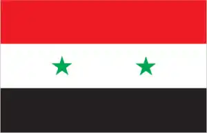
- The national symbols are hawk; the national colors: red, white, black, and green.
- Internet TLD: .sy
Four landscapes dominate the country’s surface: the fertile, narrow Mediterranean coastline, the 2000 m high Antilibanon mountain chains, the river-irrigated interior plains, and the Syrian desert in the southeast. In addition to its present territory, historic Syria once included Jordan, Israel, and Lebanon. The area was conquered by the Mesopotamian Akkadians, the Egyptians, Hittites, and Phoenicians, followed by the Persians, Greeks, and the Roman Empire. Under the Muslim Umayyads, Damascus became the capital of the entire Islamic world. The Crusader conquests are commemorated by Crac des Chevaliers’ exceptionally intact Crusader castle, built in the 12th century. Founded in the 3rd millennium BC, Damascus boasts some 125 monuments from different periods of history.
The ruins of Bosra, the capital of the Roman province of Arabia, lie along the caravan route to Mecca. The monumental remains of the oasis of Palmyra in the Syrian desert bear witness to one of the most important cultural centers of the ancient world, preserving Greek, Roman, Persian, and Arabic traditions. Aleppo has been ruled by Hittites, Assyrians, Arabs, Mongols, Mamelukes, and Turks at the crossroads of empires and cultures over the last four thousand years. Its 13th-century fortress, Great Mosque, Medrese, palaces, and caravanserais have become an integral part of the modern cityscape, which is now under the most significant threat of overpopulation.
Syria is an ancient land; there are at least 3500 as yet unexcavated archaeological sites.
Background
Following World War I, France acquired a mandate over the northern portion of Syria’s former Ottoman Empire province. The French administered the area as Syria until granting its independence in 1946. The new country lacked political stability and experienced a series of military coups. Syria united with Egypt in February 1958 to form the United Arab Republic. In September 1961, the two entities separated, and the Syrian Arab Republic was reestablished. In the 1967 Arab-Israeli War, Syria lost the Golan Heights region to Israel. During the 1990s, Syria and Israel held occasional, albeit unsuccessful, peace talks over its return. In November 1970, Hafiz al-ASAD, a member of the socialist Baath Party and the minority Alawi sect, seized power in a bloodless coup and brought political stability to the country. Following the death of President Hafiz al-ASAD, his son, Bashar al-ASAD, was approved as president by a popular referendum in July 2000. Syrian troops – stationed in Lebanon since 1976 in an ostensible peacekeeping role – were withdrawn in April 2005. During the July-August 2006 conflict between Israel and Hizballah, Syria placed its military forces on alert but did not intervene directly on behalf of its ally Hizballah. In May 2007, Bashar al-ASADs second term as president was approved by a popular referendum.
Influenced by major uprisings that began elsewhere in the region and compounded by additional social and economic factors, anti-government protests broke out first in the southern province of Dara in March 2011, with protesters calling for the repeal of the restrictive Emergency Law allowing arrests without charge, the legalization of political parties, and the removal of corrupt local officials. Demonstrations and violent unrest spread across Syria, with the size and intensity of protests fluctuating. The government responded to unrest with concessions – including the repeal of the Emergency Law, new laws permitting new political parties, and liberalizing local and national elections – and with military force and detentions. The government’s efforts to quell unrest and armed opposition activity led to extended clashes and eventually civil war between government forces, allies, and oppositionists.
International pressure on the ASAD regime intensified after late 2011. The Arab League, the EU, Turkey, and the US expanded economic sanctions against the regime and those entities that support it. In December 2012, the Syrian National Coalition was recognized by more than 130 countries as the sole legitimate representative of the Syrian people. In September 2015, Russia launched a military intervention on behalf of the ASAD regime, and domestic and foreign government-aligned forces recaptured swaths of territory from opposition forces, and eventually, the country’s second-largest city, Aleppo, in December 2016, shifting the conflict in the regime’s favor. With this foreign support, the regime also recaptured opposition strongholds in the Damascus suburbs and the southern province of Dara in 2018. The government lacks territorial control over much of the northeastern part of the country, dominated by the predominantly Kurdish Syrian Democratic Forces (SDF). The SDF has expanded its territorial hold over much of the northeast since 2014 as it has captured territory from the Islamic State of Iraq and Syria. Since 2016, Turkey has also conducted three large-scale military operations in Syria, capturing territory along Syria’s northern border in Aleppo, Ar Raqqah, and Al Hasakah. Political negotiations between the government and opposition delegations at UN-sponsored Geneva conferences since 2014 have failed to produce a resolution of the conflict.
Since early 2017, Iran, Russia, and Turkey have held separate political negotiations outside of UN auspices to attempt to reduce violence in Syria. According to an April 2016 UN estimate, the death toll among Syrian Government forces, opposition forces, and civilians was over 400,000, though other estimates placed well over 500,000. As of December 2019, approximately 6 million Syrians were internally displaced. Approximately 11.1 million people needed humanitarian assistance across the country, and an additional 5.7 million Syrians were registered refugees in Turkey, Jordan, Iraq, Egypt, and North Africa. The conflict in Syria remains one of the most significant humanitarian crises worldwide.
Geography
A low range of hills backs a short stretch of the coastal plain. The Euphrates River cuts through a vast interior desert plateau.
Stretching from the eastern Mediterranean to the Tigris River, Syrias borders are regarded as an artificial creation of French colonial rule by many Syrians. Civil war erupted in 2011.
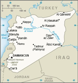
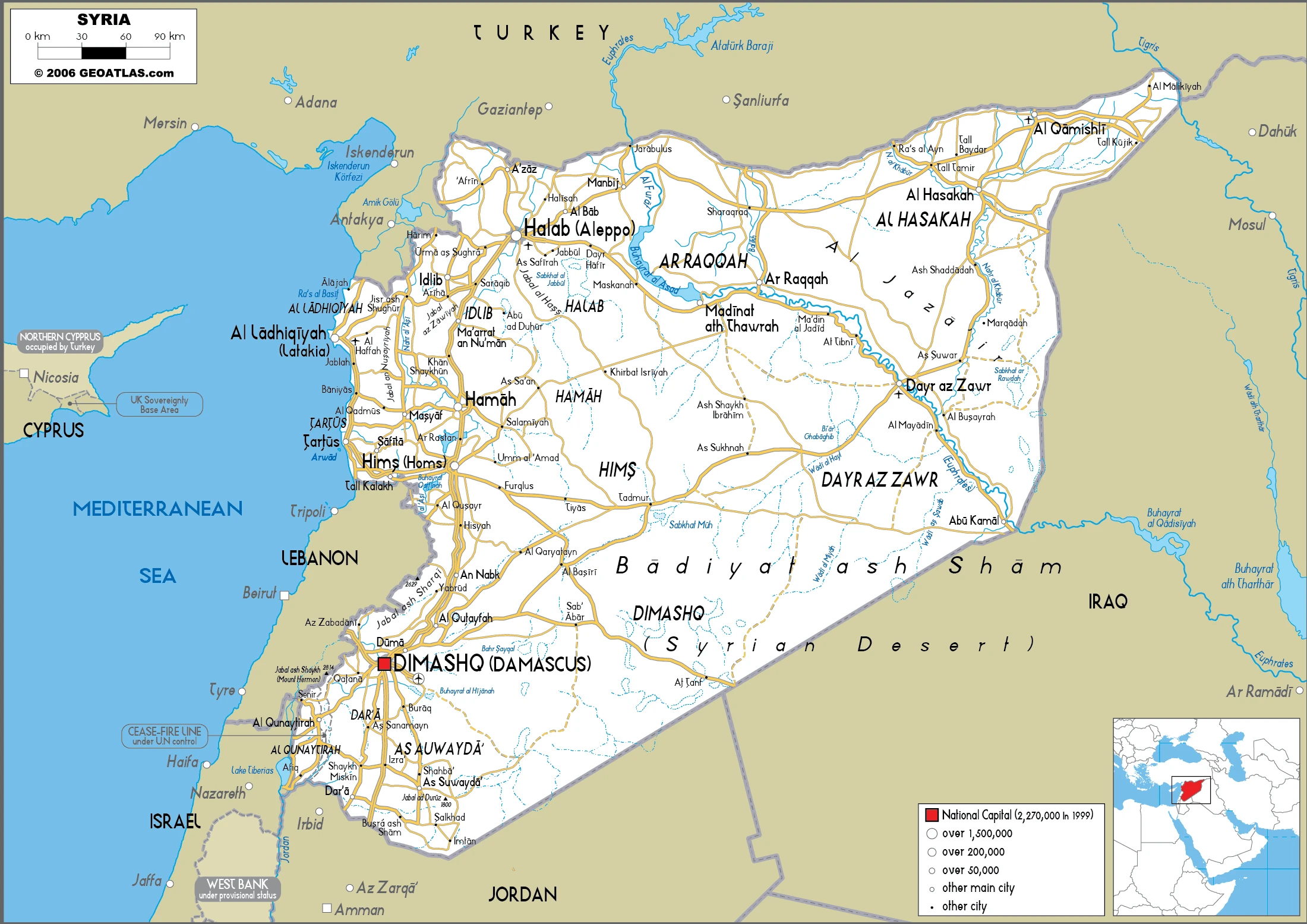
This state is located in the Middle East, bordering the Mediterranean Sea, between Lebanon and Turkey, under the coordinates of 35 00 N, 38 00 E, covering an area of 187,437 sq km with a coastline of 193 km. Syria is Slightly more than 1.5 times the size of Pennsylvania.
Syria has 2,363 km of land boundaries and borders (5 nations): Iraq 599 km, Israel 83 km, Jordan 379 km, Lebanon 403 km, and Turkey 899 km.
Primarily semiarid and desert plateau, narrow coastal plain, mountains in the west, with Mount Hermon (Jabal a-Shayk) 2,814 m as the highest point of Syria, while unknown location near Lake Tiberias -208 m as the lowest point, causing a mean elevation at 514 m throughout the country. With a total of 187,437 sq km, Syria has 185,887 sq km of land and 1,550 sq km of water surface area.
Major water bodies in the country: Euphrates (shared with Turkey, Iran, and Iraq) – 3,596 km, Tigris (shared with Turkey, Iran, and Iraq) – 1,950 km. The significant watersheds for Syria are the Indian Ocean drainage: (Persian Gulf), Tigris, and Euphrates (918,044 sq km).
The capital of Damascus – located at an oasis fed by the Barada River – is thought to be one of the world’s oldest continuously inhabited cities; there are 42 Israeli settlements and civilian land use sites in the Israeli-controlled Golan Heights (2017).
The climate in Syria is mostly desert, with hot, dry, sunny summers (June to August) and mild, rainy winters (December to February) along the coast and cold weather with snow or sleet periodically in Damascus.
When you visit Syria, the natural hazards shall be considered: Dust storms, sandstorms, and volcanism: Syria’s two historically active volcanoes, Es Safa and an unnamed volcano near the Turkish border, have not erupted in centuries.
The following major health-threatening issues shall be considered when visiting Syria: none.
Current environmental issues affecting the Syrian people: deforestation, overgrazing; soil erosion; desertification; depletion of water resources; water pollution from raw sewage and petroleum refining wastes, and inadequate potable water.
Google Maps Syria
The capital and other divisions
Capital city: Damascus found under the coordinates 33 30 N, 36 18 E, applying the time zone UTC+2 (7 hours ahead of Washington, DC, during Standard Time), using the following daylight saving time: +1hr begins midnight on the last Friday in March; ends at midnight on the last Friday in October.
Damascus, the capital of Syria, is a large and important city. It is also notable for being one of the oldest continuously inhabited cities globally. Many different empires have ruled Damascus throughout its history, most notably the Roman and Byzantine empires. The architecture of Damascus is typically medium to high-rise buildings with rounded and square corners. There are many green spaces in the city, including parks and gardens and public squares that are often covered by trees. There are 60% Muslims and 25% Christians, with the remaining 15% mostly Druze. The city has been destroyed many times by earthquakes, and it is considered one of the oldest continuously inhabited cities on earth.
Syria became independent on 17 April 1946 (from League of Nations mandate under French administration), and its national holiday is Independence Day (Evacuation Day), 17 April (1946).
Administrative divisions: 14 provinces (muhafazat, singular – muhafazah); Al Hasakah, Al Ladhiqiyah (Latakia), Al Qunaytirah, Ar Raqqah, As Suwayda, Dara, Dayr az Zawr, Dimashq (Damascus), Halab (Aleppo), Hamah, Hims (Homs), Idlib, Rif Dimashq (Damascus Countryside), Tartus.
People and society
Towns tend to lie within 60 miles (100 km) of the coast. Most Syrians are Sunni Muslims, but the Shia Alawis control politics. The authoritarian Assad regime, in power since 1970, fiercely repressed pro-democracy “Arab Spring” protests in 2011, and the brutal conflict soon broke out. Two hundred thousand have been killed, and ten million are displaced, including many Palestinians and Iraqis formerly sheltering in Syrian refugee camps. Islamic State (IS) jihadists control the Euphrates valley.
The population in Syria is 20,384,316 (July 2021 estimate). Note: approximately 22,900 Israeli settlers live in the Golan Heights (2018), with an average of NA (2021 estimate) change. That means Syria is the No. 61 in the world’s populated rank list. With an average of 23.5 years median age (23 years for males and 23 years for women), Syria ranks No. 177 on the globe’s median age rank list.
The people living in this country are the Syrian(s) (noun) or Syrian (adjective) and belong mainly to the following ethnic groups: Arab ~50%, Alawite ~15%, Kurd ~10%, Levantine ~10%, other ~15% (includes Druze, Ismaili, Imami, Nusairi, Assyrian, Turkoman, Armenian).
They speak Arabic (official language), Kurdish, Armenian, Aramaic, Circassian, French, and English languages and practice the following religions: Muslim 87% (official; includes Sunni 74% and Alawi, Ismaili, and Shia 13%), Christian 10% (includes Orthodox, Uniate, and Nestorian), Druze 3% note: the Christian population may be considerably smaller as a result of Christians fleeing the country during the ongoing civil war.
We can conclude the following about the population in Syria: Significant population density along the Mediterranean coast. Larger concentrations are found in the major cities of Damascus, Aleppo (the country’s largest city), and Hims (Homs). More than half of the population lives in the coastal plain, the province of Halab, and the Euphrates river valley. In Syria, we are talking about 56.1% (2021) of the total population lives in cities, and most of them reside in the following municipalities: 2.440 million, Damascus (capital city), 2.004 million, Aleppo, 1.362 million, Hims (Homs), 940,000 Hamah (2021).
Industry
The conflict has destroyed the economy. Oil fields held by rebels, production down. Sanctions limit exports. Lack of food and medicines. Infrastructure bombed.
Syria’s economy has deeply deteriorated amid the ongoing conflict in 2011, declining by more than 70% from 2010 to 2017. The government has struggled to address the effects of international sanctions fully, widespread infrastructure damage, diminished domestic consumption and production, reduced subsidies, and high inflation, which have caused dwindling foreign exchange reserves, rising budget and trade deficits, a decreasing value of the Syrian pound, and falling household purchasing power. In 2017, some economic indicators began to stabilize, including the exchange rate and inflation, but economic activity remains depressed, and GDP almost certainly fell. In 2017, the ongoing conflict and continued unrest, and economic decline worsened the humanitarian crisis, necessitating high levels of international assistance, as more than 13 million people remain in need inside Syria, and the number of registered Syrian refugees increased from 4.8 million in 2016 to more than 5.4 million. Before the turmoil, Damascus had begun liberalizing economic policies, including cutting lending interest rates, opening private banks, consolidating multiple exchange rates, raising prices on some subsidized items, and establishing the Damascus Stock Exchange economy remains highly regulated. Long-run economic constraints include foreign trade barriers, declining oil production, high unemployment, rising budget deficits, increasing pressure on water supplies caused by heavy use in agriculture, industrial contraction, water pollution, and widespread infrastructure damage.
Syria is rich in the following natural resources: Petroleum, phosphates, chrome and manganese ores, asphalt, iron ore, rock salt, marble, gypsum, and hydropower.
The main industrial sectors are petroleum, textiles, food processing, beverages, tobacco, phosphate rock mining, cement, oil seeds crushing, and automobile assembly.
The country’s export sectors are robust in olive oil, cumin seeds, pistachios, tomatoes, apples, pears, spices, and pitted fruits (2019), partnering with these nations: Saudi Arabia 23%, Turkey 18%, Egypt 14%, United Arab Emirates 8%, Jordan 7%, Kuwait 5% (2019). The export trade resulted in $1.85 billion. Note: Data are in current year dollars (2017 estimate). In a global rank of the export, values resulted in Syria’s position of 154.
Land use in Syria: 2.7% (2018 estimate) forest, 21.5% (2018 estimate) other.
The arable land area is 25.4% (2018 estimate), and the agricultural land is 75.8% (2018 estimate). Land use for permanent crops 5.8% (2018 estimate), permanent pasture 44.6% (2018 estimate). The sum of the area of the irrigated land is 14,280 sq km (2012).
The main agro-industrial products of Syria are wheat, barley, milk, olives, tomatoes, oranges, potatoes, sheep milk, lemons, and limes.
The country typically needs to import: cigarettes, broadcasting equipment, wheat flours, sunflower oil, and refined petroleum (2019), partnering with the following nations: Turkey 27%, China 22%, United Arab Emirates 14%, Egypt 5% (2019) in a sum value of $6.279 billion (2017 estimate) $5.496 billion (2016 estimate). This sum value on the global ranking list of imports resulted in Syria 128.
Syria Driving Directions
In this post, you learned about Syria, the Middle East bordering the Mediterranean Sea, between Lebanon and Turkey. We published some basic information about its capital Damascus, and the Syrian nation.
Are you interested in visiting Syria and looking for driving directions? Click here to plan your route, or see a printable road map of Syria below for an overview of the route network.
Printable map of Syria
Did you know about Syria?
Syria is one of the most dangerous countries in the world. According to the World Health Organization, over two million people have died due to the war in Syria. Over half of the population has been displaced, and over nine million people need humanitarian assistance. The situation is getting worse by the day, and it’s unclear when or if the war will end.
The country has been divided into areas controlled by different factions, and there have been numerous reports of violence and human rights abuses.
Syria is also one of the most diverse countries globally, with over 120 different ethnic groups.
After virtually visiting Syria, you may also be interested in the neighboring countries: Iraq, Israel, Jordan, Lebanon, and Turkey.
If you liked our Google map and Syria information page,
please share it with others or save the link https://www.drivingdirections.net in your bookmarks.