
Lebanon Google Maps is a site/tool that offers a wide range of map views (topographic, satellite, street view) and navigation options, with little effort on your part, yet efficiently. If you need to plan a trip to a new place like Lebanon, Google maps are available on desktop, mobile, or tablet. This Google maps and information page is dedicated to Lebanon, Middle East (19 countries), showing its location, country facts, details about its capital city Beirut, bordering countries like Israel, Syria, and plenty of other information which may be interesting when you visit this Middle Eastern state.
Quick links: Google Maps Lebanon, Beirut Google maps, Driving Directions Lebanon, Printable Road Map.
About Lebanon in a nutshell
- Conventional short form of the name: Lebanon
- The conventional long form of the name: Lebanese Republic
- Local long form: Al Jumhuriyah al Lubnaniyah
- Local short form: Lubnan
- Former name(s): Greater Lebanon
- Etymology: derives from the Semitic root lbn meaning white and refers to snow-capped Mount Lebanon.
- The legal system in Lebanon: mixed legal system of civil law based on the French civil code, Ottoman legal tradition, and religious laws covering personal status, marriage, divorce, and other family relations of the Jewish, Islamic, and Christian communities.
- Climate: Winters are mild and summers are hot, with high coastal humidity. Snow falls on high ground in winter.
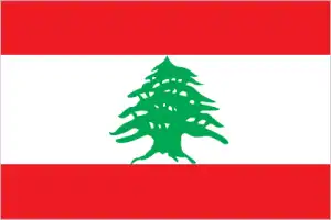
- The national symbols are cedar tree; national colors: red, white, green.
- Internet TLD: .lb
The double ridge of the tiny state’s surface is formed by the forested Mount Lebanon, rising to 3,000 m. The barren ridges of the lower, drier Antilibanon Mountains run parallel. The country’s densely populated cities almost invariably occupy the narrow coastal strip. The Bekaa Valley, the country’s central wine-growing region, stretches for about 150 km between the two mountain ranges parallel to the coast. The cedar forests that once wholly covered the ridges of the Lebanese mountains are now only patches. The Bible’s “Canaan flowing with milk and honey” has attracted traders, conquerors, and adventurers for thousands of years. Settled 4,500 years ago, the trading Phoenicians were followed by Assyrians, Persians, Alexander the Great, the Romans, the Muslim Umayyads, Jews and Christians, Syrian Maronites, Persian Abbasids, then the Crusaders, the Mamelukes, and finally the Ottoman Turkish Empire.
Lebanon gained its independence after World War II. After a civil war between Muslims and Christians that broke out in 1975 and lasted for some 20 years, it is only in the third millennium that Lebanon begins to recover from its ruins. Tourism and the country’s World Heritage sites are benefiting from this. Thousands of pilgrims visited the Shrine of Jupiter in Baalbek during Roman times. The birthplace of Christianity, the Kadisha Valley, home to early Christian monasteries and one of the last remaining cedar forests in Lebanon, is a symbol of the ancient kingdom of Israel. Byblos is one of the oldest cities on Earth, continuously inhabited since the Neolithic period: it is the birthplace of the Phoenician alphabet, the ancestor of our modern writing. According to legend, Byblos was the site of discovering the Byblos dyes; sailors from the Phoenician city founded Carthage and Cadiz, and its monuments date back to Roman times. The palace city of Anjar founded in the 8th century: the finest example of Umayyad-era town planning.
The Cedar of Lebanon has been the nations symbol for more than 2000 years.
Background
Following World War I, France acquired a mandate over the northern portion of the former Ottoman Empire province of Syria. The French demarcated the region of Lebanon in 1920 and granted this area independence in 1943. Since independence, the country has been marked by periods of political turmoil interspersed with prosperity built on its position as a regional center for finance and trade. The country’s 1975-90 civil war, which resulted in an estimated 120,000 fatalities, was followed by years of social and political instability. Sectarianism is a crucial element of Lebanese political life. Neighboring Syria has historically influenced Lebanon’s foreign policy and internal policies, and its military occupied Lebanon from 1976 until 2005. The Lebanon-based Hizballah militia and Israel continued attacks and counterattacks against each other after Syria’s withdrawal and fought a brief war in 2006. Lebanon’s borders with Syria and Israel remain unresolved.
Geography
Behind a narrow Mediterranean coastal plain, two parallel mountain ranges run the country’s length, separated by the fertile Beqaa Valley.
Once a vibrant cultural hotspot, Lebanon suffered 14 years of civil war and occupation until a 1989 peace deal. It now fears spillover from neighboring Syria’s civil war.
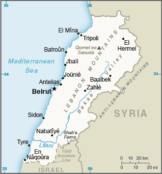
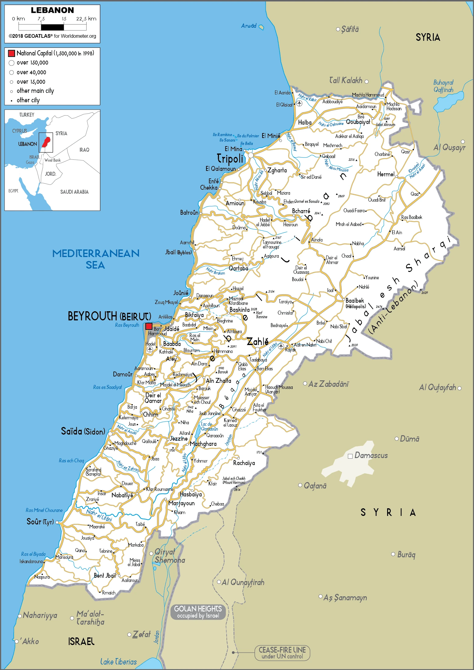
This state is located in the Middle East, bordering the Mediterranean Sea, between Israel and Syria, under the coordinates of 33 50 N, 35 50 E, covering an area of 10,400 sq km with a coastline of 225 km. Lebanon is About one-third the size of Maryland.
Lebanon has 484 km of land boundaries in total and borders with (2 nations): Israel 81 km, Syria 403 km.
The narrow coastal plain, El Beqaa (Bekaa Valley), separates Lebanon and anti-Lebanon mountains, with Qornet es Saouda 3,088 m as the highest point of Lebanon, while the Mediterranean Sea 0 m as the lowest point, causing a mean elevation at 1,250 m throughout the country. With a total of 10,400 sq km, Lebanon has 10,230 sq km of land and 170 sq km water surface area.
The smallest country in continental Asia, Nahr el Litani is the only major river in Near East not crossing an international boundary; rugged terrain historically helped isolate, protect, and develop numerous factional groups based on religion, clan, and ethnicity.
The climate in Lebanon is as follows: the Mediterranean, mild to cool, wet winters with hot, dry summers, the Lebanon mountains experience heavy winter snows.
When you visit Lebanon, the natural hazards shall be considered: Earthquakes, dust storms, sandstorms.
The following major health-threatening issues shall be considered when visiting Lebanon: none.
Current environmental issues affecting the Lebanese people: deforestation; soil deterioration, erosion; desertification; species loss; air pollution in Beirut from vehicular traffic and the burning of industrial wastes; pollution of coastal waters from raw sewage and oil spills; waste-water management.
Google Maps Lebanon
The capital and other divisions
Capital city: Beirut found under the coordinates 33 52 N, 35 30 E, applying the time zone UTC+2 (7 hours ahead of Washington, DC, during Standard Time), using the following daylight saving time: +1hr begins last Sunday in March; ends last Sunday in October.
Beirut is the capital and largest city of Lebanon. Beirut is considered the Middle East’s cultural crossroads. The city features a wide range of architectural styles, ranging from Ottoman to Christian to modern or post-modern; a multi-faith society with a Muslim majority, with small Christian, Druse, and Jewish minorities; and a long history as an important trading center between East and West that has also been home to many non-Lebanese expatriates.
Lebanon became independent on 22 November 1943 (from League of Nations mandate under French administration), and its national holiday is Independence Day, 22 November (1943).
Administrative divisions: 8 governorates (mohafazat, singular – mohafazah); Aakkar, Baalbek-Hermel, Beqaa (Bekaa), Beyrouth (Beirut), Liban-Nord (North Lebanon), Liban-Sud (South Lebanon), Mont-Liban (Mount Lebanon), Nabatiye.
People and society
A vast gulf exists between the poor and a small, wealthy elite. Politics reflects divisions between the traditional ruling Maronite Christians and Sunni and Shia Muslims. A 1989 power-sharing deal ended the civil war. Syria acted as a power broker until made to withdraw in 2005. Political crises add to instability. Israel attacked in 2006 in a botched bid to crush Iran-backed Hezbollah militants. Lebanon hosts over a million Syrian refugees and 450,000 from Palestine.
The population in Lebanon is 5,261,372 (July 2021 estimate), with an average of 0.68% (2021 estimate) change. That means Lebanon is the No. 121 in the world’s populated rank list. With an average of 33.7 years median age (33.1 years for males and 33.1 years for women), Lebanon ranks No. 95 on the globe’s median age rank list.
The people living in this country are the Lebanese (also singular and plural) (noun) or Lebanese (adjective) and belong mainly to the following ethnic groups: Arab 95%, Armenian 4%, other 1%. Note: many Christian Lebanese do not identify themselves as Arab but rather as descendants of the ancient Canaanites and prefer to be called Phoenicians.
They speak Arabic (official language), French, English, Armenian languages and practice the following religions: Muslim 61.1% (30.6% Sunni, 30.5% Shia, smaller percentages of Alawites and Ismailis), Christian 33.7% (Maronite Catholics are the largest Christian group), Druze 5.2%, tiny numbers of Jews, Bahais, Buddhists, and Hindus (2018 estimate), note: data represent the religious affiliation of the citizen population (data do not include Lebanon’s sizable Syrian and Palestinian refugee populations); 18 religious sects recognized.
We can conclude the following about the population in Lebanon: The majority of the people live on or near the Mediterranean coast, and most live in and around the capital, Beirut. Favorable growing conditions in the Bekaa valley, on the southeastern side of the Lebanon mountains, have attracted farmers, and thus the area exhibits a smaller population density. In Lebanon, we are talking about 89.1% (2021) of the total population is living in cities, and most of them reside in the following municipalities: 2.435 million, Beirut (capital city) (2021).
Industry
Wine and fruit. Much infrastructure was destroyed. Instability undermines Beiruts role as a regional financial center. High public debt. Refugee influx.
Lebanon has a free-market economy and a strong laissez-faire commercial tradition. However, the government does not restrict foreign investment; the investment climate suffers from red tape, corruption, arbitrary licensing decisions, complex customs procedures, high taxes, tariffs, fees, archaic legislation, and inadequate intellectual property rights protection. The Lebanese economy is service-oriented; main growth sectors include banking and tourism. The 1975-90 civil war seriously damaged Lebanon’s economic infrastructure, cut national output by half, and derailed Lebanon’s position as a Middle Eastern banking hub. Following the civil war, Lebanon rebuilt much of its war-torn physical and financial infrastructure by borrowing heavily, mostly from domestic banks, which saddled the government with a huge debt burden. Pledges of economic and financial reforms made at separate international donor conferences during the 2000s have mostly gone unfulfilled, including those made during the Paris III Donor Conference in 2007, following the July 2006 war.
The CEDRE investment event hosted by France in April 2018 again rallied the international community to assist Lebanon with concessional financing and some grants for capital infrastructure improvements, conditioned upon long-delayed structural economic reforms in fiscal management, electricity tariffs, and transparent public procurement, among many others. The Syria conflict cut off Lebanon’s major markets and a transport corridor through the Levant. The influx of nearly one million registered and an estimated 300,000 unregistered Syrian refugees have increased social tensions and heightened competition for low-skill jobs and public services. Lebanon continues to face several long-term structural weaknesses that predate the Syria crisis, notably, weak infrastructure, poor service delivery, institutionalized corruption, and bureaucratic over-regulation. Chronic fiscal deficits have increased Lebanon’s debt-to-GDP ratio, the third-highest globally; most of the debt is held internally by Lebanese banks. These factors combined to slow economic growth to the 1-2% range in 2011-17, after four years of averaging 8% growth.
Weak economic growth limits tax revenues, while the most significant government expenditures remain debt servicing, salaries for government workers, and transfers to the electricity sector. These limitations constrain government spending, limiting its ability to invest in necessary infrastructure improvements, such as water, electricity, and transportation. In early 2018, the Lebanese government signed long-awaited contract agreements with an international consortium for petroleum exploration and production as part of the country’s first offshore licensing round. Exploration is expected to begin in 2019.
Lebanon is rich in the following natural resources: Limestone, iron ore, salt, a water-surplus state in a water-deficit region, arable land.
The main industrial sectors are banking, tourism, real estate and construction, food processing, wine, jewelry, cement, textiles, mineral and chemical products, wood and furniture, oil refining, and metal fabricating.
The country’s export sectors are particularly strong in gold, jewelry, shotguns, diamonds, scrap copper (2019), partnering with these nations: Switzerland 27%, United Arab Emirates 15%, South Korea 11%, Saudi Arabia 7%, Kuwait 6% (2019). The export trade resulted in $18.17 billion. Note: Data are in current year dollars (2019 estimate). In a global rank of the export, values resulted in Lebanon’s position of 87.
Land use in Lebanon: 13.4% (2018 estimate) forest, 23.3% (2018 estimate) other.
The arable land area is 11.9% (2018 estimate), and the agricultural land is 63.3% (2018 estimate). Land use for permanent crops 12.3% (2018 estimate), permanent pasture 39.1% (2018 estimate). The sum of the area of the irrigated land is 1,040 sq km (2012).
The main agro-industrial products of Lebanon are potatoes, milk, tomatoes, apples, oranges, olives, wheat, cucumbers, poultry, lemons.
The country typically needs to import: refined petroleum, cars, packaged medicines, jewelry, gold (2019), partnering with the following nations: the United Arab Emirates 11%, China 10%, Italy 8%, Greece 8%, Turkey 7%, United States 6% (2019) in a sum value of $31.34 billion. Note: data are in current year dollars (2019 estimate) $32.78 billion. Note: data are in current year dollars (2018 estimate). This sum value on the global ranking list of imports resulted in Lebanon 70.
Lebanon Driving Directions
In this post, you learned about Lebanon, the Middle East, bordering the Mediterranean Sea, between Israel and Syria. We published some basic information about its capital Beirut, and the Lebanese nation.
Are you interested in visiting Lebanon and looking for driving directions? Click here to plan your route, or see a printable road map of Lebanon below for an overview of the route network.
Printable map of Lebanon
Did you know about Lebanon?
Lebanon is one of the oldest countries globally, and it’s a perfect destination for history buffs. The country was ruled by everyone from the Greeks to the Romans to the Maans, and they left behind many ruins, including temples and castles. It also has excellent food, delicious wines, and a booming nightlife scene.
Lebanon’s diverse population includes people from many other cultures who have immigrated there throughout history. In recent years, people from Syria have been moving there due to the war in their country. The number of refugees from Syria has increased significantly over the last few years.
After virtually visiting Lebanon, you may also be interested in the neighboring countries: Israel, Syria.
If you liked our Google map and Lebanon information page,
please share it with others or save the link https://www.drivingdirections.net in your bookmarks.