
Ghana Google Maps is a site/tool that offers a wide range of map views (topographic, satellite, street view) and navigation options, with little effort on your part, yet efficiently. If you need to plan a trip to a new place like Ghana, Google maps are available on desktop, mobile, or tablet. This Google maps and information page is dedicated to Ghana, Africa (54 countries), showing its location, country facts, details about its capital city Accra, bordering countries like Burkina Faso, Côte d’Ivoire, Togo, and plenty of other information which may be interesting when you visit this African state.
Quick links: Google Maps Ghana, Accra Google maps, Driving Directions Ghana, Printable Road Map.
About Ghana in a nutshell
- Ghana was the first colony in west Africa to gain independence.
- Conventional short form of the name: Ghana
- The conventional long form of the name: Republic of Ghana
- Former name(s): Gold Coast
- Etymology: named for the medieval West African kingdom of the same name but whose location was actually further north than the modern country.
- The legal system in Ghana: mixed system of English common law and customary law.
- Climate: Tropical. There are two wet seasons in the south, but the north is drier, and has just one.
- The national symbols are black star, golden eagle; national colors: red, yellow, green, black.
- Internet TLD: .gh
The coast of Ghana has been inhabited for 40 000 years. The first Europeans, the Portuguese, landed here in the late 15th century searching for fabulous gold treasures, but the slave trade later proved to be a much bigger business. By the end of the 16th century, Portuguese, Dutch, Danish, Swedish, and British traders transported tens of thousands of enslaved people a year from the Gulf of Guinea to the Americas. Fortresses were built along the coast to hold enslaved people: by the 19th century, an average of 76 forts were built every 6 kilometers along the Gold Coast. Some forts have survived intact: on the sandy coastline west of Accra, some 250 km long, 15 forts stand among small, colorful fishing villages.
The remaining forts are part of Ghana’s national heritage, a World Heritage Site. In the country’s interior, Kumasi is the capital of the Ashanti Kingdom, which flourished in the 18th century and is the most important cultural center in West Africa and still preserves the kingdom’s tradition. The simple residence and burial place of the Ashanti kings still stands here – the current king lives right next to the old palace. Kumasi is the city of the ‘Golden Harness’: the throne of kings is said to have descended from the sky. Kumasi’s traditional Ashanti buildings are a World Heritage Site. In the various towns of Ghana, following the cycles of the 42-day Ashanti calendar, there is a festival almost every month of the year: chiefs and priests, hunters and fishers also hold their colorful masked celebrations, accompanied by music and dance.
Background
Formed from the merger of the British colony of the Gold Coast and the Togoland trust territory, Ghana in 1957 became the first Sub-Saharan country in colonial Africa to gain its independence. Ghana endured a series of coups before Lt. Jerry RAWLINGS took power in 1981 and banned political parties. After approving a new constitution and restoring multiparty politics in 1992, RAWLINGS won presidential elections in 1992 and 1996 but was constitutionally prevented from running for a third term in 2000. John KUFUOR of the opposition New Patriotic Party (NPP) succeeded him and was reelected in 2004. John Atta MILLS of the National Democratic Congress won the 2008 presidential election and took over as head of state. MILLS died in July 2012 and was constitutionally succeeded by his vice president, John Dramani MAHAMA, who subsequently won the December 2012 presidential election. In 2016, Nana Addo Dankwa AKUFO-ADDO of the NPP defeated MAHAMA, marking the third time that Ghana’s presidency has changed parties since the return to democracy.
Geography
Mostly low-lying. The west is covered by rainforest. One of the worlds largest artificial lakes , Lake Volta, was created by damming the White Volta River.
The heartland of the ancient Ashanti kingdom, Ghana in West Africa, was once known as the Gold Coast. It has experienced intermittent periods of military rule since independence in 1957.
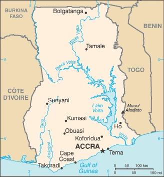
This state is located in Western Africa, bordering the Gulf of Guinea, between Côte d’Ivoire and Togo, under the coordinates of 8 00 N, 2 00 W, covering an area of 238,533 sq km with a coastline of 539 km. Ghana is Slightly smaller than Oregon.
Ghana has 2,420 km of land boundaries in total, and bordering with (3 nations): Burkina Faso 602 km, Côte d’Ivoire 720 km, Togo 1098 km.
Mostly low plains with dissected plateau in the south-central area, with Mount Afadjato 885 m as the highest point of Ghana, while Atlantic Ocean 0 m as the lowest point, causing a mean elevation at 190 m throughout the country. With 238,533 sq km, Ghana has 227,533 sq km of land and 11,000 sq km water surface.
The principal river is the Volta river mouth (shared with Burkina Faso’s) – 1,600 km. The significant watersheds for Ghana are Atlantic Ocean drainage: Volta (410,991 sq km).
Lake Volta is the world’s largest artificial lake (manufactured reservoir) by surface area (8,482 sq km; 3,275 sq mi); the lake was created following the completion of the Akosombo Dam in 1965 back the White Volta and Black Volta Rivers.
The climate in Ghana is as follows: Tropical, warm, and comparatively dry along the southeast coast, hot and humid in the southwest, hot and dry in the north.
When you visit Ghana, the natural hazards shall be considered: Dry, dusty, northeastern harmattan winds from January to March; droughts.
The following major health-threatening issues shall be considered when visiting Ghana: degree of risk: very high (2020), bacterial and protozoal diarrhea, hepatitis A, typhoid fever, malaria, dengue fever, yellow fever, schistosomiasis, rabies, meningococcal meningitis.
Current environmental issues affecting the Ghanaian people: recurrent drought in the north severely affect agricultural activities; deforestation; overgrazing; soil erosion; poaching and habitat destruction threaten wildlife populations; water pollution; inadequate supplies of potable water.
Google Maps Ghana
The capital and other divisions
Capital city: Accra found under the coordinates 5 33 N, 0 13 W, applying the time zone UTC 0 (5 hours ahead of Washington, DC, during Standard Time), using the following daylight saving time: none.
Accra is the capital of Ghana and is located in the greater Accra metropolitan area. It’s notorious for housing one of Africa’s largest markets, a vibrant music scene, and a wide variety of cuisine. This city has seen its fair share of political unrest and violence.
Ghana became independent on 6 March 1957 (from the UK), and its national holiday is Independence Day, 6 March (1957).
Administrative divisions: 16 regions; Ahafo, Ashanti, Bono, Bono East, Central, Eastern, Greater Accra, North East, Northern, Oti, Savannah, Upper East, Upper West, Volta, Western, Western North.
People and society
Around 75 cultural-linguistic groups. The largest is the Akan, which includes the Ashanti and Fanti peoples. Southern peoples are more prosperous and more urban than those of the north. There are few tribal tensions. Family ties are strong. Women play a significant role in market trading. The 2000 election saw Ghanas first peaceful handover of power. Poverty levels have been significantly reduced.
The population in Ghana is 32,372,889 (July 2021 estimate). Note: estimates for this country explicitly take into account the effects of excess mortality due to AIDS; this can result in lower life expectancy, higher infant mortality, higher death rates, lower population growth rates, and changes in the distribution of the population by age and sex than would otherwise be expected, with an average of 2.26% (2021 estimate) change. That means Ghana is the No. 44 in the world’s populated rank list. With an average of 21.4 years median age (21 years for males and 21 years for women), Ghana ranks No. 184 on the globe’s median age rank list.
The people living in this country are the Ghanaian(s) (noun) or Ghanaian (adjective) and belong mainly to the following ethnic groups: Akan 47.5%, Mole-Dagbon 16.6%, Ewe 13.9%, Ga-Dangme 7.4%, Gurma 5.7%, Guan 3.7%, Grusi 2.5%, Mande 1.1%, other 1.4% (2010 estimate).
They speak Asante 16%, Ewe 14%, Fante 11.6%, Boron (Brong) 4.9%, Dagomba 4.4%, Dangme 4.2%, Dagarte (Dagaba) 3.9%, Kokomba 3.5%, Akyem 3.2%, Ga 3.1%, other 31.2% (2010 estimate). Note: English is the official language languages and practice the following religions: Christian 71.2% (Pentecostal/Charismatic 28.3%, Protestant 18.4%, Catholic 13.1%, other 11.4%), Muslim 17.6%, traditional 5.2%, other 0.8%, none 5.2% (2010 estimate).
We can conclude the following about the population in Ghana: Population is concentrated in the southern half of the country, with the highest concentrations being on or near the Atlantic coast, as shown in this population distribution map. In Ghana, we are talking about 58% (2021) of the total population is living in cities, and most of them reside in the following municipalities: 3.390 million, Kumasi, 2.557 million, Accra (capital city), 991,000 Sekondi Takoradi (2021).
Industry
Worlds second-largest cocoa producer. Oil discovered in 2007: on stream from 2010. Hardwood trees such as maple and Sapele. Gold mining.
Ghana has a market-based economy with relatively few policy barriers to trade and investment compared to other countries in the region, and Ghana is endowed with natural resources. Ghana’s economy was strengthened by a quarter-century of relatively sound management, a competitive business environment, and sustained reductions in poverty levels, but in recent years has suffered the consequences of loose fiscal policy, high budget and current account deficits, and a depreciating currency., Agriculture accounts for about 20% of GDP and employs more than half of the workforce, mainly small landholders. Gold, oil, cocoa exports, and individual remittances are significant sources of foreign exchange. Expansion of Ghana’s nascent oil industry has boosted economic growth, but the fall in oil prices since 2015 reduced by half Ghana’s oil revenue.
Production at Jubilee, Ghana’s first commercial offshore oilfield, began in mid-December 2010. Production from two more fields, TEN and Sankofa, started in 2016 and 2017. The country’s first gas processing plant at Atuabo is also producing natural gas from the Jubilee field, providing power to several of Ghana’s thermal power plants., As of 2018, the government’s vital economic concerns include the lack of affordable electricity, a solid domestic revenue base, and the high debt burden. The AKUFO-ADDO administration has made some progress by committing to fiscal consolidation, but much work is still to be done. Ghana signed a $920 million extended credit facility with the IMF in April 2015 to help it address its growing economic crisis.
The IMF fiscal targets require Ghana to reduce the deficit by cutting subsidies, decreasing the bloated public sector wage bill, strengthening revenue administration, boosting tax revenues, and improving the health of Ghana’s banking sector. Priorities for the new administration include rescheduling some of Ghana’s $31 billion debt, stimulating economic growth, reducing inflation, and stabilizing the currency. Prospects for new oil and gas production and following through on tighter fiscal management are likely to help Ghana’s economy in 2018.
Ghana is rich in natural resources: Gold, timber, industrial diamonds, bauxite, manganese, fish, rubber, hydropower, petroleum, silver, salt, limestone.
The main industrial sectors are mining, lumbering, light manufacturing, aluminum smelting, food processing, cement, small commercial shipbuilding, petroleum.
The country’s export sectors are particularly strong in gold, crude petroleum, cocoa products, manganese, cashews (2019), partnering with these nations: Switzerland 23%, India 17%, China 12%, United Arab Emirates 8%, South Africa 8% (2019). The export trade resulted in $25.59 billion. Note: Data are in current year dollars (2019 estimate). In a global rank of the export, values resulted in Ghana’s position of 73.
Land use in Ghana: 21.2% (2018 estimate) forest, 9.7% (2018 estimate) other.
The arable land area is 20.7% (2018 estimate), and the agricultural land is 69.1% (2018 estimate). Land use for permanent crops 11.9% (2018 estimate), permanent pasture 36.5% (2018 estimate). The sum of the area of the irrigated land is 340 sq km (2012).
The main agro-industrial products of Ghana are cassava, yams, plantains, maize, oil palm fruit, taro, rice, cocoa, oranges, pineapples.
The country typically needs to import: metal tubing, ships, cars, refined petroleum, rice (2019), partnering with the following nations: China 24%, Nigeria 22%, United States 5% (2019) in a sum value of $26.91 billion. Note: data are in current year dollars (2019 estimate) $23.22 billion. Note: data are in current year dollars (2018 estimate). This sum value on the global ranking list of imports resulted in Ghana 74.
Ghana Driving Directions
In this post, you learned about Ghana, Western Africa, bordering the Gulf of Guinea, between Côte d’Ivoire and Togo. We published some basic information about its capital Accra, and the Ghanaian nation.
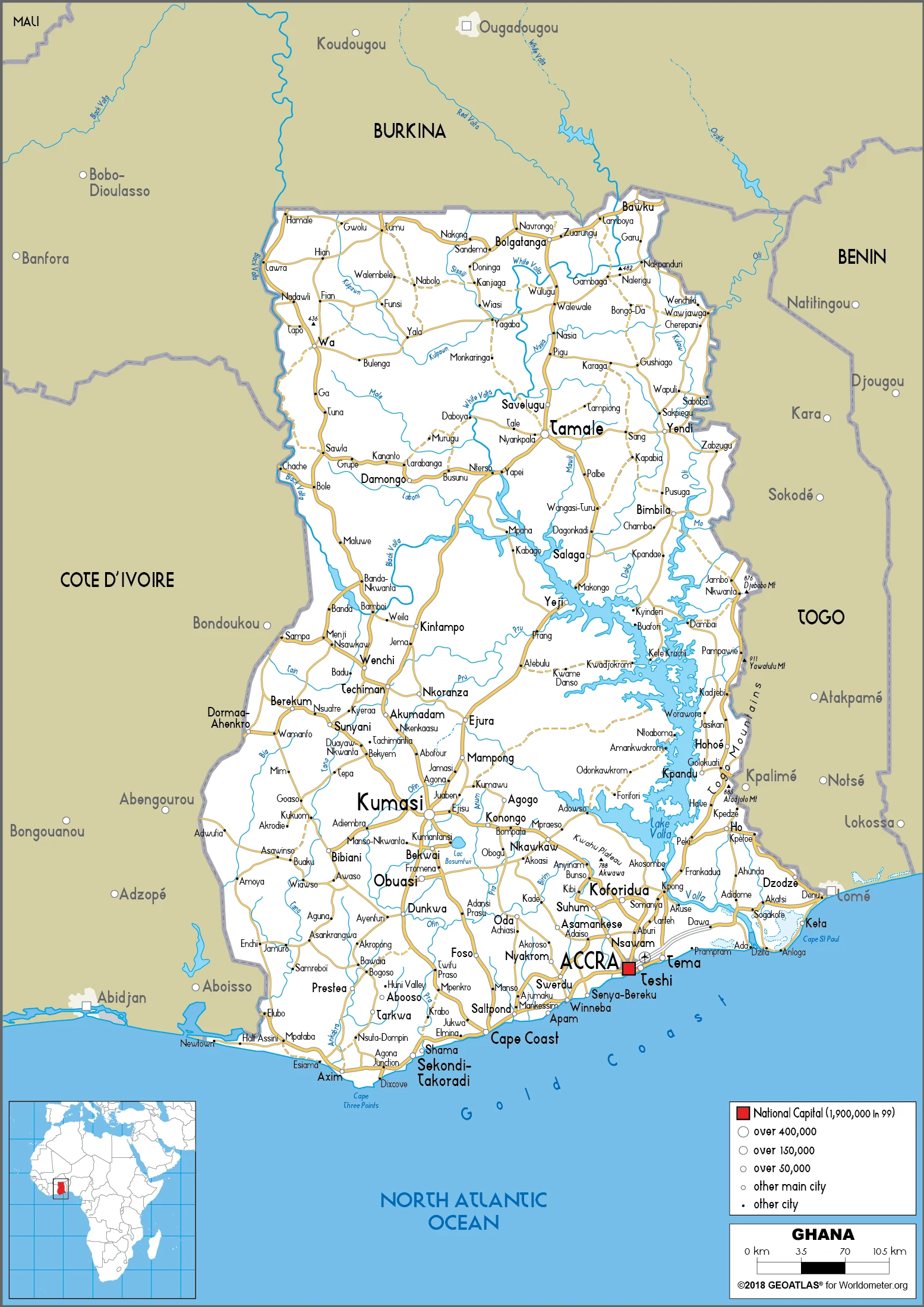
Are you interested in visiting Ghana and looking for driving directions? Click here to plan your route, or see a printable road map of Ghana below for an overview of the route network.
Printable map of Ghana
Did you know about Ghana?
The country is the second-most populous on the continent of Africa, and it is a Cocoa-producing nation. Ghana has a long history and a rich legacy that dates back to its pre-colonial period. The country has also been called the Gold Coast because of the gold trade that was done there for centuries. The people of Ghana are colorful and very friendly, making sure to give you a big welcome to their country.
After virtually visiting Ghana, you may also be interested in the neighboring countries: Burkina Faso, Côte d’Ivoire, Togo.
If you liked our Google map and Ghana information page,
please share it with others or save the link https://www.drivingdirections.net in your bookmarks.