
Guatemala Google Maps is a site/tool that offers a wide range of map views (topographic, satellite, street view) and navigation options, with little effort on your part, yet efficiently. If you need to plan a trip to a new place like Guatemala, Google maps are available on desktop, mobile, or tablet. This Google maps and information page is dedicated to Guatemala, Central America, and the Caribbean (35 countries), showing its location, country facts, details about its capital city Guatemala City, bordering countries like Belize, El Salvador, Honduras, Mexico, and plenty of other information which may be interesting when you visit this Central American and the Caribbean state.
Quick links: Google Maps Guatemala, Guatemala City Google maps, Driving Directions Guatemala, Printable Road Map.
About Guatemala in a nutshell
- Guatemala, which means “land of trees,” was the center of the ancient Mayan civilization.
- Conventional short form of the name: Guatemala
- The conventional long form of the name: Republic of Guatemala
- Local long form: Republica de Guatemala
- Local short form: Guatemala
- Former name(s): N/A
- Etymology: the Spanish conquistadors used many native Americans as allies in their conquest of Guatemala; the site of their first capital (established in 1524), a former Maya settlement, was called Quauhtemallan by their Nahuatl-speaking Mexican allies, a name that means land of trees or forested land, but which the Spanish pronounced Guatemala; the Spanish applied that name to a re founded capital city three years later and eventually it became the name of the country.
- The legal system in Guatemala: civil law system; judicial review of legislative acts.
- Climate: Tropical: hot and humid in coastal regions and north. More temperate in central highlands.
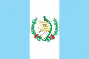
- The national symbols are quetzal (bird); national colors: blue, white.
- Internet TLD: .gt
Background
The Maya civilization flourished in Guatemala and surrounding regions during the first millennium A.D. After almost three centuries as a Spanish colony, Guatemala won its independence in 1821. During the second half of the 20th century, it experienced a variety of military and civilian governments and 36-year guerrilla war. In 1996, the government signed a peace agreement formally ending the internal conflict.
Geography
Narrow Pacific coastal plain. Central highlands with volcanoes. Short coast on the Caribbean Sea. Tropical rainforests in the north.
The largest and most populous nation on the Central American isthmus, Guatemala returned to civilian rule in 1986 after 32 years of violent and repressive military rule.
This state is located in Central America, bordering the North Pacific Ocean, between El Salvador and Mexico, and bordering the Gulf of Honduras (Caribbean Sea) between Honduras and Belize, under the coordinates of 15 30 N, 90 15 W, covering an area of 108,889 sq km with a coastline of 400 km. Guatemala is Slightly smaller than Pennsylvania.
Guatemala has 1,667 km of land boundaries in total and borders with (4 nations): Belize 266 km, El Salvador 199 km, Honduras 244 km, Mexico 958 km.
Two east-west trending mountain chains divide the country into three regions: the mountainous highlands, the pacific coast south of mountains, and the vast northern Peten lowlands, with Volcan Tajumulco (highest point in Central America) 4,220 m as the highest point of Guatemala, while Pacific Ocean 0 m as the lowest point, causing a mean elevation at 759 m throughout the country. With a total of 108,889 sq km, Guatemala has 107,159 sq km of land and 1,730 sq km water surface area.
Major water bodies in the country: Lago de Izabal – 590 sq km (a freshwater lake).
Despite having both eastern and western coastlines (the Caribbean Sea and the Pacific Ocean, respectively), there are no natural harbors on the west coast.
The climate in Guatemala is as follows: Tropical, hot, humid in lowlands, more relaxed in highlands.
When you visit Guatemala, the natural hazards shall be considered: Numerous volcanoes in the mountains, with occasional violent earthquakes; Caribbean coast extremely susceptible to hurricanes and other tropical storms volcanism: significant volcanic activity in the Sierra Madre range; Santa Maria (3,772 m) has been deemed a decade volcano by the international association of volcanology and chemistry of the interior of the earth, worthy of study due to its tumultuous history and proximity to human populations; Pacaya (2,552 m), which erupted in may 2010 causing ashfall on Guatemala city and prompting evacuations, is one of the country’s most active volcanoes with frequent eruptions since 1965; other historically active volcanoes include Acatenango, Almolonga, Atitlan, Fuego, and Tacana.
The following major health-threatening issues shall be considered when visiting Guatemala: degree of risk: high (2020), bacterial diarrhea, hepatitis A, typhoid fever, dengue fever, and malaria.
Current environmental issues affecting the Guatemalan people: deforestation in the Peten rainforest; soil erosion; water pollution.
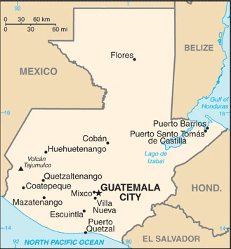
Google Maps Guatemala
The capital and other divisions
Capital city: Guatemala City found under the coordinates 14 37 N, 90 31 W, applying the time zone UTC-6 (1 hour behind Washington, DC, during Standard Time), using the following daylight saving time: none.
The capital of Guatemala is not only recognized for its historical buildings and beautiful attractions; it’s also a bustling metropolis brimming with culture. The city is home to over 2 million residents, and one of its main attractions is the Cathedral Basilica of St. James, a well-known tourist destination.
Guatemala became independent on 15 September 1821 (from Spain), and its national holiday is Independence Day, 15 September (1821).
Administrative divisions: 22 departments (departamentos, singular – departamento); Alta Verapaz, Baja Verapaz, Chimaltenango, Chiquimula, El Progreso, Escuintla, Guatemala, Huehuetenango, Izabal, Jalapa, Jutiapa, Peten, Quetzaltenango, Quiche, Retalhuleu, Sacatepequez, San Marcos, Santa Rosa, Solola, Suchitepequez, Totonicapan, Zacapa.
People and society
Amerindians, concentrated in the highlands, form a majority. Power, wealth, and land are controlled by ladinos (Westernized Amerindians and mestizos). Catholicism is predominant, mixed with Amerindian beliefs. Literacy is low. A quarter of the population lives on less than $2 a day. Violent crime is a problem.
The population in Guatemala is 17,422,821 (July 2021 estimate), with an average of 1.62% (2021 estimate) change. That means Guatemala is the No. 67 in the world’s populated rank list. With an average of 23.2 years median age (22.6 years for males and 22.6 years for women), Guatemala ranks No. 178 on the globe’s median age rank list.
The people living in this country are the Guatemalan(s) (noun) or Guatemalan (adjective) and belong mainly to the following ethnic groups: Mestizo (mixed Amerindian-Spanish – in local Spanish called Ladino) 56%, Maya 41.7%, Xinca (Indigenous, non-Maya) 1.8%, African descent 0.2%, Garifuna (mixed West and Central African, Island Carib, and Arawak) 0.1%, foreign 0.2% (2018 estimate).
They speak Spanish (official language) 69.9%, Maya languages 29.7% (Qeqchi 8.3%, Kiche 7.8%, Mam 4.4%, Kaqchikel 3%, Qanjobal 1.2%, Poqomchi 1%, other 4%), other 0.4% (includes Xinca and Garifuna); languages and practice the following religions: Roman Catholic 41.7%, Evangelical 38.8%, other 2.7%, atheist 0.1%, none 13.8%, unspecified 2.9% (2018 estimate).
We can conclude the following about the population in Guatemala: The vast majority of the populace resides in the southern half of the country, particularly in the mountainous regions. More than half of the population lives in rural areas. In Guatemala, we are talking about 52.2% (2021) of the total population is living in cities, and most of them reside in the following municipalities: 2.983 million, Guatemala City (capital city) (2021).
Industry
Coffee, sugar, and bananas are top exports. Tourism. Damage from natural disasters. Marked wealth inequalities inhibit the domestic market.
Guatemala is the most populous country in Central America, with roughly half the average GDP per capita for Latin America and the Caribbean. The agricultural sector accounts for 13.5% of GDP and 31% of the labor force; key agricultural exports include sugar, coffee, bananas, and vegetables. Guatemala is the top remittance recipient in Central America as a result of Guatemala’s large expatriate community in the U.S. These inflows are a primary source of foreign income, equivalent to two-thirds of the country’s exports and about a tenth of its GDP., The 1996 piece accords, which ended 36 years of civil war, removed a significant obstacle to foreign investment, and Guatemala has since pursued necessary reforms and macroeconomic stabilization.
The Dominican Republic-Central America Free Trade Agreement (CAFTA-DR) entered into force in July 2006, spurring increased investment and diversification of exports, with the most significant increases in ethanol and non-traditional agricultural exports. While CAFTA-DR has helped improve the investment climate, security concerns, the lack of skilled workers, and poor infrastructure continue to hamper foreign direct investment. The income distribution remains highly unequal, with the wealthiest 20% of the population accounting for more than 51% of Guatemala’s consumption. More than half of the population is below the national poverty line, and 23% live in extreme poverty. Poverty among indigenous groups, which make up more than 40% of the population, averages 79%, with 40% of the indigenous population living in extreme poverty. Nearly one-half of Guatemala’s children under age five are chronically malnourished, one of the highest malnutrition rates in the world.
Guatemala is rich in the following natural resources: Petroleum, nickel, rare woods, fish, chicle, hydropower.
The main industrial sectors are typically sugar, textiles, clothing, furniture, chemicals, petroleum, metals, rubber, tourism.
The country’s export sectors are particularly strong in bananas, raw sugar, coffee, cardamom, palm oil (2019), partnering with these nations: the United States 33%, El Salvador 12%, Honduras 8%, Mexico 5%, Nicaragua 5% (2019). The export trade resulted in $13.12 billion. Note: Data are in current year dollars (2020 estimate). In a global export rank, values resulted in Guatemala’s position of 97.
Land use in Guatemala: 33.6% (2018 estimate) forest, 25.2% (2018 estimate) other.
The arable land area is 14.2% (2018 estimate), and the agricultural land is 41.2% (2018 estimate). Land use for permanent crops 8.8% (2018 estimate), permanent pasture 18.2% (2018 estimate). The sum of the area of the irrigated land is 3,375 sq km (2012).
The main agro-industrial products of Guatemala are sugar cane, bananas, oil palm fruit, maize, melons, potatoes, milk, plantains, pineapples, rubber.
The country typically needs to import: refined petroleum, broadcasting equipment, packaged medicines, cars, delivery trucks (2019), partnering with the following nations: the United States 36%, China 12%, Mexico 11%, El Salvador 5% (2019) in a sum value of $19.3 billion. Note: data are in current year dollars (2020 estimate) $21.52 billion. Note: data are in current year dollars (2019 estimate) $21.17 billion. Note: data are in current year dollars (2018 estimate). This sum value on the global ranking list of imports resulted in Guatemala 87.
Guatemala Driving Directions
In this post, you learned about Guatemala, Central America, bordering the North Pacific Ocean, El Salvador and Mexico, and the Gulf of Honduras (Caribbean Sea) between Honduras and Belize. We published some basic information about its capital Guatemala City, and the Guatemalan nation.
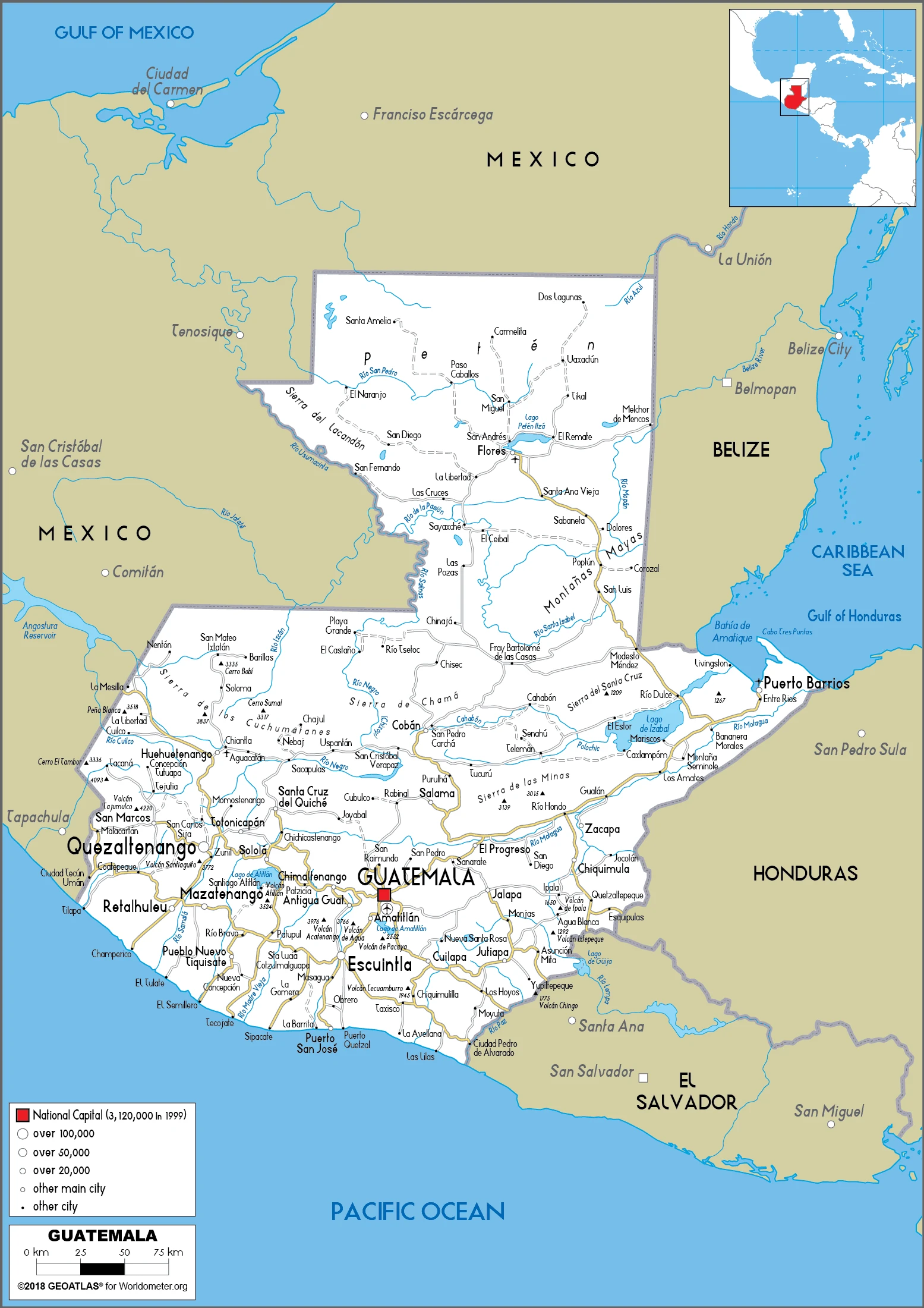
Are you interested in visiting Guatemala and looking for driving directions? Click here to plan your route, or see a printable road map of Guatemala below for an overview of the route network.
Printable map of Guatemala
Did you know about Guatemala?
Guatemala is geographically divided into highlands, lowlands, and coastal areas. It stretches over a total of 154,540 square miles and has about 17,5 million people.
After virtually visiting Guatemala, you may also be interested in the neighboring countries: Belize, El Salvador, Honduras, Mexico.
If you liked our Google map and Guatemala information page,
please share it with others or save the link https://www.drivingdirections.net in your bookmarks.