
Guinea-Bissau Google Maps is a site/tool that offers a wide range of map views (topographic, satellite, street view) and navigation options, with little effort on your part, yet efficiently. If you need to plan a trip to a new place like Guinea-Bissau, Google maps are available on desktop, mobile, or tablet. This Google maps and information page is dedicated to Guinea-Bissau, Africa (54 countries), showing its location, country facts, details about its capital city, Bissau, bordering countries like Guinea, Senegal, and plenty of other information which may be interesting when you visit this African state.
Quick links: Google Maps Guinea-Bissau, Bissau Google maps, Driving Directions Guinea-Bissau, Printable Road Map.
About Guinea-Bissau in a nutshell
- In 1974, Guinea-Bissau became the first Portuguese colony to gain independence.
- Conventional short form of the name: Guinea-Bissau
- The conventional long form of the name: Republic of Guinea-Bissau
- Local long form: Republica da Guine-Bissau
- Local short form: Guine-Bissau
- Former name(s): Portuguese Guinea
- Etymology: the country is named after the Guinea region of West Africa that lies along the Gulf of Guinea and stretches north to the Sahel; Bissau, the name of the capital city, distinguishes the country from neighboring Guinea.
- The legal system in Guinea-Bissau: mixed legal system of civil law, which incorporated Portuguese law at independence and influenced by Economic Community of West African States (ECOWAS), West African Economic and Monetary Union (UEMOA), African Francophone Public Law, and customary law.
- Climate: Tropical, with wet season May- November and dry season December- April. Hot, dry harmattan desert wind blows during dry season.
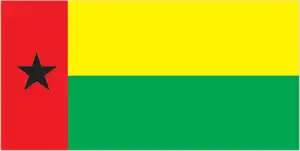
- The national symbols are black star; national colors: red, yellow, green, black.
- Internet TLD: .gw
Background
For much of its history, Guinea-Bissau was under the control of the Mali Empire and the Kaabu kingdom. In the 16th century, Portugal began establishing trading posts along Guinea-Bissau’s shoreline. Initially, the Portuguese were restricted to the coastline and islands. However, the enslaved person and gold trade was lucrative to local African leaders, and the Portuguese were slowly able to expand their power and influence inland. Starting in the 18th century, the Mali Empire and the Kingdom of Kaabu slowly disintegrated into smaller local entities. By the 19th century, Portugal had fully incorporated Guinea-Bissau into its empire. Since gaining independence in 1974, Guinea-Bissau has experienced considerable political and military upheaval. In 1980, a military coup established General Joao Bernardo Nino VIEIRA as president.
Vieira’s regime suppressed political opposition and purged political rivals. Several coup attempts through the 1980s and early 1990s failed to unseat him. In May 1999, a military mutiny and civil war led to VIEIRAs ouster. In February 2000, a transitional government turned the power to opposition leader Kumba YALA. In September 2003, a bloodless military coup overthrew YALA and installed businessman Henrique ROSA as interim president. In 2005, former President VIEIRA was reelected to pursue economic development and national reconciliation. He was assassinated in March 2009. In June 2009, Malam Bacai SANHA was elected, but he passed away in January 2012 from a long-term illness. In April 2012, a military coup prevented the second round of the presidential election. Following mediation from the Economic Community of Western African States (ECOWAS), a transitional civilian government assumed power. In 2014, Jose Mario VAZ won a free and fair election. In June 2019, VAZ became the first president in Guinea-Bissau to complete a full presidential term. After winning the 2019 presidential elections, Umaro SISSOCO EMBALO was president.
Geography
Low-lying, apart from savanna highlands in the northeast. Rainforests and swamps are found along with coastal areas.
Known as Portuguese Guinea while a colony, Guinea-Bissau lies on Africas west coast. Since 1994, its nascent democracy has been plagued by coups and rebellions.
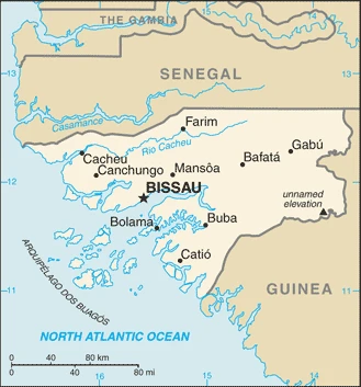
This state is located in Western Africa, bordering the North Atlantic Ocean, between Guinea and Senegal, under the coordinates of 12 00 N, 15 00 W, covering an area of 36,125 sq km with a coastline of 350 km. Guinea-Bissau is Slightly less than three times the size of Connecticut.
Guinea-Bissau has 762 km of land boundaries in total and borders with (2 nations): Guinea 421 km, Senegal 341 km.
Mostly low-lying coastal plain with a profoundly indented estuarine coastline rising to savanna in the east, numerous offshore islands including the archipelago dos Bijagos consisting of 18 main islands and many small islets, with Unnamed elevation in the eastern part of the country 300 m as the highest point of Guinea-Bissau, while Atlantic Ocean 0 m as the lowest point, causing a mean elevation at 70 m throughout the country. With a total of 36,125 sq km, Guinea-Bissau has 28,120 sq km of land and 8,005 sq km water surface area.
This small country is swampy along its western coast and low-lying inland.
The climate in Guinea-Bissau is as follows: Tropical, generally hot and humid, monsoonal-type rainy season (June to November) with southwesterly winds, dry season (December to May) with northeasterly harmattan winds.
When you visit Guinea-Bissau, the natural hazards shall be considered: Hot, dry, dusty harmattan haze may reduce visibility during the dry season; brush fires.
The following major health-threatening issues shall be considered when visiting Guinea-Bissau: degree of risk: very high (2020), bacterial and protozoal diarrhea, hepatitis A, and typhoid fever, malaria, dengue fever, and yellow fever, schistosomiasis, rabies.
Current environmental issues affecting the Bissau-Guinean people: deforestation (rampant felling of trees for timber and agricultural purposes); soil erosion; overgrazing; overfishing.
Google Maps Guinea-Bissau
The capital and other divisions
Capital city: Bissau found under the coordinates 11 51 N, 15 35 W, applying the time zone UTC 0 (5 hours ahead of Washington, DC, during Standard Time), using the following daylight saving time: none.
Bissau is the capital city of Guinea-Bissau and the country’s most populous city. Bissau is an old colonial port city on the Atlantic Ocean in West Africa. The name Bissau means “the mouth of the river” in Portuguese.
Guinea-Bissau became independent on 24 September 1973 (declared); 10 September 1974 (from Portugal), and its national holiday is Independence Day, 24 September (1973).
Administrative divisions: 9 regions (regioes, singular – regiao); Bafata, Biombo, Bissau, Bolama/Bijagos, Cacheu, Gabu, Oio, Quinara, Tombali.
People and society
The largest ethnic group is the Balante, who live in the south. Though only around 1% of the population, the mixed-race PortugueseAfrican mestiços dominate the top ranks of government and bureaucracy. Most people live and work on small family farms, grouped in self-contained villages. The bulk of the urban population lives in Bissau, where they face economic hardship. Narcotics traffickers are taking advantage of the ongoing instability.
The population in Guinea-Bissau is 1,976,187 (July 2021 estimate), with an average of 2.52% (2021 estimate) change. That means Guinea-Bissau is the No. 150 in the world’s populated rank list. With an average of 18 years median age (17.4 years for males and 17.4 years for women), Guinea-Bissau ranks No. 214 on the globe’s median age rank list.
The people living in this country are the Bissau-Guinean(s) (noun) or Bissau-Guinean (adjective) and belong mainly to the following ethnic groups: Fulani 28.5%, Balanta 22.5%, Mandinga 14.7%, Papel 9.1%, Manjaco 8.3%, Beafada 3.5%, Mancanha 3.1%, Bijago 2.1%, Felupe 1.7%, Mansoanca 1.4%, Balanta Mane 1%, other 1.8%, none 2.2% (2008 estimate).
They speak Portuguese-based Creole, Portuguese (official language; primarily used as a second or third language), Pular (a Fula language), Mandingo languages and practice the following religions: Muslim 45.1%, Christian 22.1%, animist 14.9%, none 2%, unspecified 15.9% (2008 estimate).
We can conclude the following about the population in Guinea-Bissau: Approximately one-fifth of the population lives in the capital city of Bissau along the Atlantic coast. The remainder is distributed among the eight other, mainly rural, regions as shown in this population distribution map. In Guinea-Bissau, we are talking about 44.6% (2021) of the total population is living in cities, and most of them reside in the following municipalities: 621,000 Bissau (capital city) (2021).
Industry
Mostly subsistence farming. Lack of sufficiency in rice staple. The main cash crop is cashew nuts. Major cocaine transit route from South America to Europe. Offshore oil as yet untapped. Fisheries and timber potential.
Guinea-Bissau is highly dependent on subsistence agriculture, cashew nut exports, and foreign assistance. Two out of three Bissau-Guineans remain below the absolute poverty line. The legal economy is based on cashews and fishing. Illegal logging and trafficking in narcotics also play significant roles. The combination of limited economic prospects, weak institutions, and favorable geography have made this West African country a way station for drugs bound for Europe. Guinea-Bissau has substantial potential for developing mineral resources, including phosphates, bauxite, and mineral sands. Offshore oil and gas exploration has begun.
The country’s climate and soil make it feasible to grow a wide range of cash crops, fruit, vegetables, and tubers; however, cashews generate more than 80% of export receipts and are the primary source of income for many rural communities. The government was deposed in August 2015, and since then, a political stalemate has resulted in weak governance and reduced donor support. The country is participating in a three-year, IMF extended credit facility program suspended because of a planned bank bailout. The program was renewed in 2017, but the major donors of direct budget support (the EU, World Bank, and African Development Bank) have halted their programs indefinitely. Diversification of the economy remains a key policy goal, but Guinea-Bissau’s poor infrastructure and business climate will constrain this effort.
Guinea-Bissau is rich in the following natural resources: Fish, timber, phosphates, bauxite, clay, granite, limestone, unexploited deposits of petroleum.
The main industrial sectors are typically agricultural products processing, beer, soft drinks.
The country’s export sectors are particularly strong in cashews, gold, fish, lumber, aluminum ores (2019), partnering with these nations: India 50%, Belgium 28%, Côte d’Ivoire 8% (2019). The export trade resulted in $290 million. Note: Data are in current year dollars (2019 estimate). In a global rank of the export, values resulted in Guinea-Bissau’s position of 202.
Land use in Guinea-Bissau: 55.2% (2018 estimate) forest, 0% (2018 estimate) other.
The arable land area is 8.2% (2018 estimate), and the agricultural land is 44.8% (2018 estimate). Land use for permanent crops 6.9% (2018 estimate), permanent pasture 29.7% (2018 estimate). The sum of the area of the irrigated land is 250 sq km (2012).
The main agro-industrial products of Guinea-Bissau are rice, cashew nuts, roots/tubers nes, oil palm fruit, plantains, cassava, groundnuts, vegetables, coconuts, fruit.
The country typically needs to import: refined petroleum, rice, wheat products, soups/broths, malt extract (2019), partnering with the following nations: Portugal 31%, Senegal 20%, China 10%, Netherlands 7%, Pakistan 7% (2019) in a sum value of $500 million. Note: data are in current year dollars (2019 estimate) $460 million. Note: data are in current year dollars (2018 estimate). This sum value on the global ranking list of imports resulted in Guinea-Bissau 203.
Guinea-Bissau Driving Directions
In this post, you learned about Guinea-Bissau, Western Africa, bordering the North Atlantic Ocean, between Guinea and Senegal. We published some basic information about its capital Bissau and the Bissau-Guinean nation.
Are you interested in visiting Guinea-Bissau and looking for driving directions? Click here to plan your route, or see a printable road map of Guinea-Bissau below for an overview of the route network.
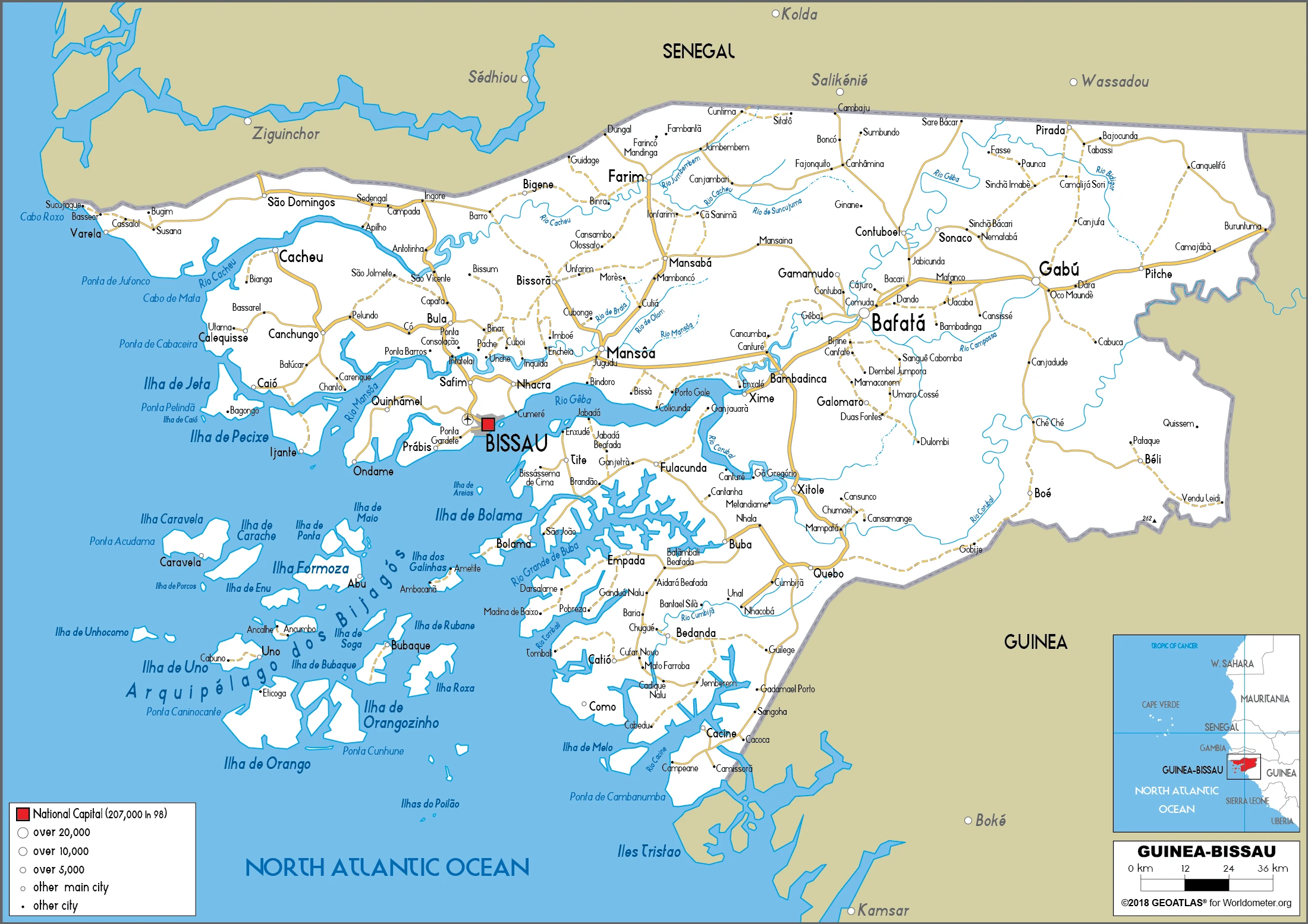
Printable map of Guinea-Bissau
Did you know about Guinea-Bissau?
It has a tropical climate, with an average temperature of 23 degrees Celsius (73.4 degrees Fahrenheit). Guinea-Bissau’s capital is Bissau, which lies between the Bijagos Archipelago and the Gulf of Guinea. This country has both arable land and rainforest.
After virtually visiting Guinea-Bissau, you may also be interested in the neighboring countries: Guinea, Senegal.
If you liked our Google map and Guinea-Bissau information page,
please share it with others or save the link https://www.drivingdirections.net in your bookmarks.