
Jan Mayen Google Maps is a site/tool that offers a wide range of map views (topographic, satellite, street view) and navigation options, with little effort on your part, yet efficiently. If you need to plan a trip to a new place like Jan Mayen, Google maps are available on desktop, mobile, or tablet. This Google maps and information page is dedicated to Jan Mayen, Arctic Region (4 countries), showing its location, country facts, details, and plenty of other information which may be interesting when you visit this Arctic state.
Quick links: Google Maps Jan Mayen, Google maps, Driving Directions Jan Mayen, Printable Road Map.
About Jan Mayen in a nutshell
- Conventional short form of the name: Jan Mayen
- The conventional long form of the name: none
- Etymology: named after Dutch Captain Jan Jacobszoon MAY, one of the first explorers to reach the island in 1614.
- The legal system in Jan Mayen: the laws of Norway apply where applicable.
- Climate: Arctic maritime with frequent storms and persistent fog.
Background
This lonely, arctic, mountainous island was named after a Dutch whaling captain who indisputably discovered it in 1614 (earlier claims are inconclusive). Visited only occasionally by seal hunters and trappers over the following centuries, the island came under Norwegian sovereignty in 1929. The long-dormant Beerenberg volcano, the northernmost active volcano on earth, resumed activity in 1970, and the most recent eruption occurred in 1985.
Geography
Jan Mayen is a small volcanic rock island in the Norwegian Arctic Ocean. It was once a solid whaling base, but now it is sparsely populated and used as a pasture for reindeer.
This state is located in Northern Europe, an island between the Greenland Sea and the Norwegian Sea, northeast of Iceland, under the coordinates of 71 00 N, 8 00 W, covering an area of 377 sq km with a coastline of 124.1 km. Jan Mayen is Slightly more than twice the size of Washington, DC.
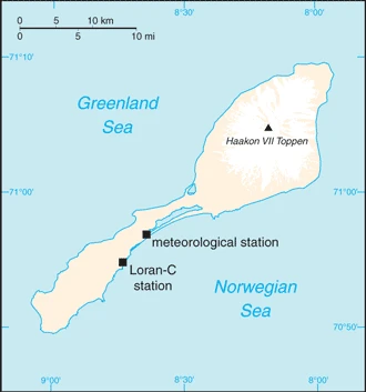
A volcanic island, partly covered by glaciers, with Haakon vii Toppen on Beerenberg 2,277 as the highest point of Jan Mayen, while Norwegian Sea 0 m as the lowest point. With a total of 377 sq km, Jan Mayen has 377 sq km of land and 0 sq km of water surface area.
Barren volcanic spoon-shaped island with some moss and grass flora; island consists of two parts: a larger northeast Nord-Jan (the spoon bowl) and the smaller Sor-Jan (the handle), linked by a 2.5 km-wide isthmus (the stem) with two large lakes, Sorlaguna (South Lagoon) and Nordlaguna (North Lagoon).
The climate in Jan Mayen is Arctic maritime with frequent storms and persistent fog.
When you visit Jan Mayen, the natural hazards shall be considered: Dominated by the volcano Beerenberg volcanism: Beerenberg (2,227 m) is Norway’s only active volcano; volcanic activity resumed in 1970; the most recent eruption occurred in 1985.
None of the following major health-threatening issues shall be considered when visiting Jan Mayen.
Current environmental issues affecting the people: pollutants transported from southerly latitudes by winds, ocean currents, and rivers accumulate in the food chains of native animals; climate change.
Google Maps Jan Mayen
The capital and other divisions
The island of Jan Mayen is the largest and only permanently inhabited territory of Norway, located in the Arctic Ocean. Denmark controls the south part of this island, but Norway controls the northern parts.
Administrative divisions: none.
Industry
Jan Mayen is a volcanic island with no exploitable natural resources, although surrounding waters contain substantial fish stocks and potential untapped petroleum resources. Economic activity is limited to providing services for employees of Norway’s radio and meteorological stations on the island.
Jan Mayen is rich in the following natural resources: none.
The leading industrial or agro-industrial products of Jan Mayen are none.
Jan Mayen Driving Directions
In this post, you learned about Jan Mayen, Northern Europe, an island between the Greenland Sea and the Norwegian Sea, northeast of Iceland. We published some basic information.
Are you interested in visiting Jan Mayen and looking for driving directions? Click here to plan your route, or see a printable road map of Jan Mayen below for an overview of the route network.
Printable map of Jan Mayen

Did you know about Jan Mayen?
Located in the Norwegian Sea, Jan Mayen Island is a volcanic island with an active volcano and part of Norway. The only inhabitants are about 50 Norwegian researchers who have lived on the island for six months. The island was discovered in 1599 by the Dutch admiral Jacob van Heemskerk.
After virtually visiting Jan Mayen, you may also be interested in the neighboring countries: none.
If you liked our Google map and Jan Mayen information page,
please share it with others or save the link https://www.drivingdirections.net in your bookmarks.