
Nepal Google Maps is a site/tool that offers a wide range of map views (topographic, satellite, street view) and navigation options, with little effort on your part, yet efficiently. If you need to plan a trip to a new place like Nepal, Google maps are available on desktop, mobile, or tablet. This Google maps and information page is dedicated to Nepal, Asia (22 countries), showing its location, country facts, details about its capital city Kathmandu, bordering countries like China, India, and plenty of other information which may be interesting when you visit this Asian state.
Quick links: Google Maps Nepal, Kathmandu Google maps, Driving Directions Nepal, Printable Road Map.
About Nepal in a nutshell
- Conventional short form of the name: Nepal
- The conventional long form of the name: none
- Local long form: none
- Local short form: Nepal
- Former name(s): N/A
- Etymology: the Newar people of the Kathmandu Valley and surrounding areas apparently gave their name to the country; the terms Nepal, Newar, Nepar, and Newal are phonetically different forms of the same word.
- The legal system in Nepal: English common law and Hindu legal concepts.
- Climate: Warm monsoon season from July to October. The rest of the year is dry, sunny, and mild. Winter temperatures in the Himalayas average 14°F (10°C).
- The national symbols are rhododendron blossom; national color: red.
- Internet TLD: .np
Sandwiched between China and India and one and a half times the size of our country, much of the country is dominated by the eight thousand meter high Himalayan chains and the Mahabharata Mountains, with the vast sub-tropical plains of the Terai in the south, fertile valleys in the center and high mountain desert in the north, bordering Tibet. The dry monsoon season from October to the end of May is ideal for tourism. The two natural and two cultural World Heritage Sites of the former kingdom are an excellent representation of the country’s main tourist attractions. On the banks of the sacred Bagmati River, the Kathmandu Valley is a veritable treasure trove of religions, arts, architecture, and ethnicities.
Hindu pagodas dating from the 16th and 17th centuries, Buddhist temples, including perhaps the most famous Swayambunath Stupa, Bhaktapur, which has preserved its medieval townscape to the fullest, and the medieval buildings of the old capital Patan, with Durbar Square, the royal palace, now form the country’s capital, Kathmandu. Prince Siddhartha Gautama, the Buddha, was born in the Terai plains, in a grove near the village of Lumbini near the Indian border in 623 BC. Four hundred years later, the Indian ruler Ashoka had a memorial pillar erected on the site, now a major Buddhist pilgrimage center. Also in the Terai area is Chitwan National Park, home to the last of the Indian rhinoceros and the Bengal tiger, most of which can be visited by elephant trek. Sagarmatha National Park is home to Mount Everest, the highest peak on the planet at 8848m.
Background
During the late 18th-early and 19th centuries, the principality of Gorkha united many of the other principalities and states of the sub-Himalayan region into the Nepali Kingdom. Nepal retained its independence following the Anglo-Nepalese War of 1814-16, and the subsequent peace treaty laid the foundations for two centuries of amicable relations between Britain and Nepal. (The Brigade of Gurkhas continues to serve in the British Army today.) In 1951, the Nepali monarch ended the century-old rule system by hereditary premiers and instituted a cabinet system that brought political parties into the government. That arrangement lasted until 1960, when political parties were again banned but were reinstated in 1990 with the establishment of a multiparty democracy within the framework of a constitutional monarchy.
An insurgency led by Maoists broke out in 1996. During the ensuing 10-year civil war between Maoist and government forces, the monarchy dissolved the cabinet and Parliament and re-assumed absolute power in 2002, after the crown prince massacred the royal family in 2001. A peace accord in 2006 led to the promulgation of an interim constitution in 2007. Following a nationwide Constituent Assembly (CA) election in 2008, the newly formed CA declared Nepal a federal democratic republic, abolished the monarchy, and elected the country’s first president. After the CA failed to draft a constitution by a 2012 deadline set by the Supreme Court, then-Prime Minister Baburam BHATTARAI dissolved the CA. Months of negotiations ensued until 2013 when the major political parties agreed to create an interim government headed by then-Chief Justice Khil Raj REGMI with a mandate to hold elections for a new CA.
Elections were held in 2013, in which the Nepali Congress (NC) won the largest share of seats in the CA, and in 2014 formed a coalition government with the second-place Communist Party of Nepal-Unified Marxist-Leninist (UML), with NC President Sushil KOIRALA serving as prime minister. Nepal’s new constitution came into effect in 2015, at which point the CA became the Parliament. Khagda Prasad Sharma OLI served as the first post-constitution prime minister from 2015 to 2016. OLI resigned ahead of a no-confidence motion against him, and Parliament elected Communist Party of Nepal-Maoist (CPN-M) leader Pushpa Kamal DAHAL (aka “Prachanda”) prime minister. The constitution provided for a transitional period during which three sets of elections, local, provincial, and national, needed to take place. The first local elections in 20 years occurred in three phases between May and September 2017, and state and federal elections proceeded in two phases in November and December 2017. The parties headed by OLI and DAHAL ran in a coalition. They swept the parliamentary elections, and OLI, who led the larger of the two parties, was sworn in as prime minister in February 2018. In May 2018, OLI and DAHAL announced the merger of their parties – the UML and CPN-M – to establish the Nepal Communist Party (NCP), which is now the ruling party in Parliament.
Geography
Mainly mountainous. The area includes some of the highest mountains in the world, including Mount Everest. Flat, fertile river plains form the south.
Nepal, lying between India and China on the southern shoulder of the Himalayas, is one of the worlds poorest countries. Its agricultural economy is heavily dependent on the monsoon.
This state is located in Southern Asia, between China and India, under the coordinates of 28 00 N, 84 00 E, covering an area of 147,181 sq km with a coastline of 0 km (landlocked country). Nepal is Slightly more significant than New York state.
Nepal has 3,159 km of land boundaries in total and borders (2 nations): China, 1389 km, India, 1770 km.
Tarai or flat river plain of the Ganges in the south, central hill region with the rugged Himalayas in the north, with Mount Everest (highest peak in Asia and highest point on Earth above sea level) 8,849 m as the highest point of Nepal, while Kanchan Kalan 70 m as the lowest point, causing a mean elevation at 2,565 m throughout the country. With a total of 147,181 sq km, Nepal has 143,351 sq km of land and 3,830 sq km of water surface area.
Major water bodies in the country: Brahmaputra (shared with India, China, Bangladesh, and Bhutan) – 3,969 km, Ganges (shared with Bangladesh and India) – 2,704 km. The significant watersheds for Nepal are Indian Ocean drainage: Brahmaputra (651,335 sq km), Ganges (1,016,124 sq km), and Indus (1,081,718 sq km).
Landlocked; strategic location between China and India; contains eight of the world’s 10 highest peaks, including Mount Everest and Kanchenjunga – the world’s tallest and third tallest mountains – on the borders with China and India, respectively.
The climate in Nepal is as follows: It varies from cool summers and severe winters in the north to subtropical summers and mild winters in the south.
When you visit Nepal, the natural hazards shall be considered: Severe thunderstorms, flooding, landslides, drought, and famine, depending on the timing, intensity, and duration of the summer monsoons.
The following major health-threatening issues shall be considered when visiting Nepal: degree of risk: high (2020), bacterial diarrhea, hepatitis A and E, typhoid fever, Japanese encephalitis, malaria, and dengue fever.
Current environmental issues affecting the Nepali people: deforestation (overuse of wood for fuel and lack of alternatives); forest degradation; soil erosion; contaminated water (with human and animal wastes, agricultural runoff, and industrial effluents); unmanaged solid waste; wildlife conservation; vehicular emissions.
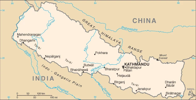
Google Maps Nepal
The capital and other divisions
Capital city: Kathmandu is found under the coordinates 27 43 N, 85 19 E, applying the time zone UTC+5.75 (10.75 hours ahead of Washington, DC, during Standard Time), using the following daylight saving time: none.
The capital of Nepal, Kathmandu, is a city that was once the capital of Tibet. It is also notable for its beautiful architecture and its unique culture that can be seen throughout the city’s many temples and artifacts. It is best known for its UNESCO World Heritage Sites and Buddhist temples. The city is also known for its street markets, which sell everything from leather goods to antiques.
Nepal became independent in 1768 (unified by Prithvi Narayan SHAH), and its national holiday is Constitution Day, 20 September (2015);.
Administrative divisions: 7 provinces (Pradesh, singular – Pradesh); Bagmati, Gandaki, Karnali, Lumbini, Province No. One, Province No. Two, Sudurpashchim.
People and society
Tensions are few between the diverse ethnic groups. Buddhist women, including Sherpas, face fewer social restrictions than Hindus. Trafficking of women and child labor are problems. Human rights violations rose during the 19992006 Maoist insurgency. The peace deal led to the abolition of the monarchy and the Maoists joining the political mainstream, but fractious coalitions mean instability continues.
The population in Nepal is 30,424,878 (July 2021 estimate), with an average of 0.81% (2021 estimate) change. That means Nepal is the No. 48 in the world’s populated rank list. With an average of 25.3 years median age (23.9 years for males and 23.9 years for women), Nepal ranks No. 161 on the globe’s median age rank list.
The people living in this country are the Nepali (also singular and plural) (noun) or Nepali (adjective) and belong mainly to the following ethnic groups: Chhettri 16.6%, Brahman-Hill 12.2%, Magar 7.1%, Tharu 6.6%, Tamang 5.8%, Newar 5%, Kami 4.8%, Muslim 4.4%, Yadav 4%, Rai 2.3%, Gurung 2%, Damai/Dholii 1.8%, Thakuri 1.6%, Limbu 1.5%, Sarki 1.4%, Teli 1.4%, Chamar/Harijan/Ram 1.3%, Koiri/Kushwaha 1.2%, other 19% (2011 estimate). Note: 125 caste/ethnic groups were reported in the 2011 national census.
They speak Nepali (official language) 44.6%, Maithali 11.7%, Bhojpuri 6%, Tharu 5.8%, Tamang 5.1%, Newar 3.2%, Bajjika 3%, Magar 3%, Doteli 3%, Urdu 2.6%, Avadhi 1.9%, Limbu 1.3%, Gurung 1.2%, Baitadeli 1%, other 6.4%, unspecified 0.2%; languages and practice the following religions: Hindu 81.3%, Buddhist 9%, Muslim 4.4%, Kirant 3.1%, Christian 1.4%, other 0.5%, unspecified 0.2% (2011 estimate).
We can conclude the following about the population in Nepal: Most of the population is divided nearly equally between a concentration in the southern-most plains of the Tarai region and the central hilly region. Overall density is relatively low. In Nepal, we are talking about 21% (2021) of the total population lives in cities, and most of them reside in the following municipalities: 1.472 million, Kathmandu (capital city) (2021).
Industry
Agriculture employs two-thirds of the workforce. Crops include rice and wheat. Tourism and investment are affected by instability. Reliant on aid and overseas remittances. Hydropower potential.
Nepal is among the least developed countries globally, with about one-quarter of its population living below the poverty line. Nepal is heavily dependent on remittances, which amount to as much as 30% of GDP. Agriculture is the mainstay of the economy, providing a livelihood for almost two-thirds of the population but accounting for less than a third of GDP. Industrial activity mainly involves processing agricultural products, including pulses, jute, sugarcane, tobacco, and grain. Nepal has considerable scope for exploiting its potential in hydropower, with an estimated 42,000 MW of commercially feasible capacity. Nepal has signed trade and investment agreements with India, China, and other countries, but political uncertainty and a challenging business climate have hampered foreign investment. The United States and Nepal signed a $500 million Millennium Challenge Corporation Compact in September 2017, which will expand Nepal’s electricity infrastructure and help maintain transportation infrastructure. Massive earthquakes struck Nepal in early 2015, which damaged or destroyed infrastructure and homes and set back economic development. Although political gridlock and lack of capacity have hindered post-earthquake recovery, government-led reconstruction efforts have progressed. However, many hard-hit areas still have little assistance. Additional challenges to Nepal’s growth include its landlocked geographic location, inconsistent electricity supply, and underdeveloped transportation infrastructure.
Nepal is rich in the following natural resources: Quartz, water, timber, hydropower, scenic beauty, small deposits of lignite, copper, cobalt, and iron ore.
The main industrial sectors are typically tourism, carpets, textiles, small rice, jute, sugar, oilseed mills, cigarettes, cement, and brick production.
The country’s export sectors are particularly strong in palm oil, clothing, and apparel, carpets, soybean oil, and flavored water (2019), partnering with these nations: India 68%, United States 10% (2019). The export trade resulted in $1.79 billion. Note: Data are in current year dollars (2020 estimate). A global rank of export values resulted in Nepal’s position of 158.
Land use in Nepal: 25.4% (2018 estimate) forest, 45.8% (2018 estimate) other.
The arable land area is 15.1% (2018 estimate), and the agricultural land is 28.8% (2018 estimate). Land use for permanent crops 1.2% (2018 estimate), permanent pasture 12.5% (2018 estimate). The sum of the area of the irrigated land is 13,320 sq km (2012).
The main agro-industrial products of Nepal are rice, vegetables, sugar cane, potatoes, maize, wheat, buffalo milk, milk, fruit, and mangoes/guavas.
The country typically needs to import: refined petroleum, iron, broadcasting equipment, natural gas, rice (2019), partnering with the following nations: India 70%, China 15% (2019) in a sum value of $10.68 billion. Note: data are in current year dollars (2020 estimate) $13.83 billion. Note: data are in current year dollars (2019 estimate) $14.65 billion. Note: data are in current year dollars (2018 estimate). This sum value on the global ranking list of imports resulted in Nepal 103.
Nepal Driving Directions
In this post, you learned about Nepal, Southern Asia, between China and India. We published some basic information about its capital Kathmandu, and the Nepali nation.
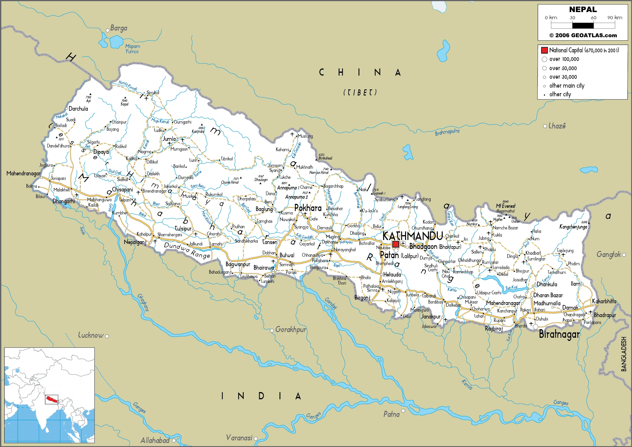
Are you interested in visiting Nepal and looking for driving directions? Click here to plan your route, or see a printable road map of Nepal below for an overview of the route network.
Printable map of Nepal
Did you know about Nepal?
Nepal is a small country in southern Asia. The country borders China, India, and the Himalayas. The nation is home to Mount Everest, which many people believe to be the tallest mountain on Earth. Nepal has been a kingdom for centuries, and an absolute monarchy has ruled it for most of its history. This changed when Nepal experienced a revolution in the early 1990s.
After virtually visiting Nepal, you may also be interested in the neighboring countries: China and India.
If you liked our Google map and Nepal information page,
please share it with others or save the link https://www.drivingdirections.net in your bookmarks.