
Bhutan Google Maps is a site/tool that offers a wide range of map views (topographic, satellite, street view) and navigation options, with little effort on your part, yet efficiently. If you need to plan a trip to a new place like Bhutan, Google maps are available on desktop, mobile, or tablet. This Google maps and information page is dedicated to Bhutan, Asia (22 countries), showing its location, country facts, details about its capital city Thimphu, bordering countries like China, India, and plenty of other information that may be interesting when you visit this Asian state.
Quick links: Google Maps Bhutan, Thimphu Google maps, Driving Directions Bhutan, Printable Road Map.
About Bhutan in a nutshell
- In 2004 Bhutan became the first country in the world to ban smoking and the sale of tobacco..
- Conventional short form of the name: Bhutan
- The conventional long form of the name: Kingdom of Bhutan
- Local long form: Druk Gyalkhap
- Local short form: Druk Yul
- Former name(s): N/A
- Etymology: named after the Bhotia, the ethnic Tibetans who migrated from Tibet to Bhutan; Bod is the Tibetan name for their land; the Bhutanese name Druk Yul means Land of the Thunder Dragon.
- The legal system in Bhutan: civil law based on Buddhist religious law.
- Climate: South is tropical, north is alpine, cold, and harsh. Central valleys warmer in east than west.
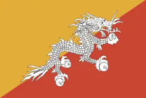
- The national symbols are thunder dragon known as Druk Gyalpo; national colors: orange, yellow.
- Internet TLD: .bt
Background
Following Britain’s victory in the 1865 Duar War, Britain and Bhutan signed the Treaty of Sinchulu. Bhutan would receive an annual subsidy for ceding land to British India. Ugyen WANGCHUCK – who had served as the de facto ruler of an increasingly unified Bhutan and had improved relations with the British toward the end of the 19th century – was named King in 1907. Three years later, a treaty was signed whereby the British agreed not to interfere in Bhutanese internal affairs, and Bhutan allowed Britain to direct its foreign affairs. Bhutan negotiated a similar arrangement with independent India in 1949.
The Indo-Bhutanese Treaty of Friendship returned to Bhutan a small piece of the territory annexed by the British, formalized the country’s annual subsidies, and defined India’s defense and foreign relations responsibilities. Under a succession of modernizing monarchs beginning in the 1950s, Bhutan joined the UN in 1971 and slowly continued its engagement beyond its borders. In 2005, King Jigme Singye WANGCHUCK unveiled the draft of Bhutan’s first constitution – which introduced major democratic reforms – and held a national referendum for its approval.
The King abdicated the throne in 2006 in favor of his son, Jigme Khesar Namgyel WANGCHUCK. In 2007, India and Bhutan renegotiated their treaty, eliminating the clause stating India would guide Bhutan in its foreign policy. However, Thimphu continues to coordinate closely with New Delhi. In 2008, Bhutan held its first parliamentary election following the constitution. Bhutan experienced a peaceful turnover of power following a parliamentary election in 2013, which resulted in the incumbent party’s defeat. In 2018, the incumbent party again lost the parliamentary election. Of the more than 100,000 ethnic Nepali – predominantly Lhotshampa – refugees who fled or were forced out of Bhutan in the 1990s, about 6,500 remain displaced in Nepal.
Geography
Low, tropical southern strip rising through fertile central valleys to the high Himalayas in the north. Around 70% of the land is forested.
Perched in the eastern Himalayas between India and China, lies the landlocked Kingdom of Bhutan. It is primarily closed to the outside world to protect its culture TV was banned until 1999.
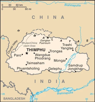
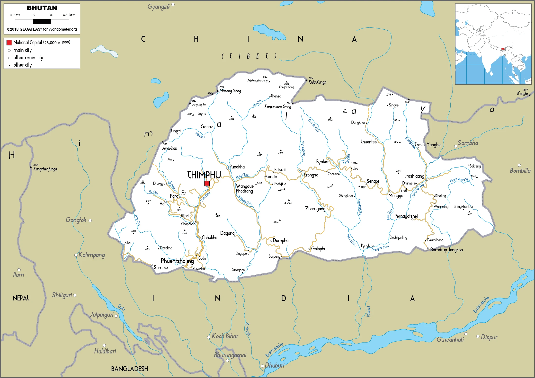
This state is located in Southern Asia, between China, and India, under the coordinates of 27 30 N, 90 30 E, covering an area of 38,394 sq km with a coastline of 0 km (landlocked country). Bhutan is Slightly larger than Maryland, about one-half the size of Indiana.
Bhutan has 1,136 km of land boundaries and borders with (2 nations): China 477 km, India 659 km.
Mostly mountainous with some fertile valleys and savanna, with Gangkar Puensum 7,570 m as the highest point of Bhutan, while Drangeme Chhu 97 m as the lowest point, causing a mean elevation at 2,220 m throughout the country. With a total of 38,394 sq km, Bhutan has 38,394 sq km of land and 0 sq km water surface area.
The principal river is Brahmaputra (shared with India, Nepal, Bangladesh, and China) – 3,969 km.
Landlocked; strategic location between China and India; controls several key Himalayan mountain passes.
The climate in Bhutan is as follows: Varies, tropical in southern plains, cool winters and hot summers in central valleys, severe winters and cool summers in the Himalayas.
When you visit Bhutan, the natural hazards shall be considered: Violent storms from the Himalayas are the source of the country’s Bhutanese name, which translates as a land of the thunder dragon; frequent landslides during the rainy season.
The following major health-threatening issues shall be considered when visiting Bhutan: none.
Current environmental issues affecting the Bhutanese people: soil erosion; limited access to potable water; wildlife conservation; industrial pollution; waste disposal.
Google Maps Bhutan
The capital and other divisions
Capital city: Thimphu found under the coordinates 27 28 N, 89 38 E, applying the time zone UTC+6 (11 hours ahead of Washington, DC, during Standard Time), using the following daylight saving time: none.
Thimphu is a small town in the north of Bhutan. It has been generally accepted that King Ugyen Wangchuck founded Thimphu in 1727, but no evidence of such a founding date exists. The town is known for its large market square and many temples and is also the most populous city in Bhutan, with a population of approximately 55,000 people.
Bhutan became independent on 17 December 1907 (became a unified kingdom under its first hereditary King); 8 August 1949 (Treaty of Friendship with India maintains Bhutanese independence), and its national holiday is National Day (Ugyen WANGCHUCK became the first hereditary King), 17 December (1907).
Administrative divisions: 20 districts (dzongkhag, singular and plural); Bumthang, Chhukha, Dagana, Gasa, Haa, Lhuentse, Mongar, Paro, Pemagatshel, Punakha, Samdrup Jongkhar, Samtse, Sarpang, Thimphu, Trashigang, Trashi Yangtse, Trongsa, Tsirang, Wangdue Phodrang, Zhemgang.
People and society
The King was an absolute monarch until 1998, and the first democratic elections were held a decade later. Most people are devoutly Buddhist and originate from Tibet. The Hindu Nepalese settled in the south. Bhutan has 20 languages. In 1988, Dzongkha (a Tibetan dialect native to just 16% of the people) was made official. The Nepalese community regards this as “cultural imperialism,” causing considerable ethnic tensions.
The population in Bhutan is 857,423 (July 2021 estimate), with an average of 0.99% (2021 estimate) change. That means Bhutan is the No. 164 in the world’s populated rank list. With an average of 29.1 years median age (29.6 years for males and 29.6 years for women), Bhutan ranks No. 136 on the globe’s median age rank list.
The people living in this country are the Bhutanese (also singular and plural) (noun) or Bhutanese (adjective) and belong mainly to the following ethnic groups: Ngalop (also known as Bhote) 50%, ethnic Nepali 35% (predominantly Lhotshampas), indigenous or migrant tribes 15%.
They speak Sharchopkha 28%, Dzongkha (official language) 24%, Lhotshamkha 22%, other 26% (includes foreign languages) (2005 estimate) languages and practice the following religions: Lamaistic Buddhist 75.3%, Indian- and Nepali-influenced Hinduism 22.1%, other 2.6% (2005 estimate).
We can conclude the following about the population in Bhutan: N/A In Bhutan, we are talking about 43% (2021) of the total population is living in cities, and most of them reside in the following municipalities: 203,000 Thimphu (capital city) (2018).
Industry
Reliant on India for trade. Most people farm their plots of land and herd cattle and yaks. Steep land unsuited for cultivation. Development of cash crops for Asian markets.
Bhutan’s small economy is mainly based on hydropower, agriculture, and forestry, which provide the main livelihood for more than half the population. Because rugged mountains dominate the terrain and make building roads and other infrastructure difficult and expensive, industrial production is primarily of the cottage industry type.
The economy is closely aligned with India through strong trade and monetary links. It is dependent on India for financial assistance and migrant laborers for development projects, especially for road construction. Bhutan signed a pact in December 2014 to expand duty-free trade with Bangladesh., Multilateral development organizations administer most educational, social, and environmental programs and consider the government’s desire to protect the country’s environment and cultural traditions. For example, the government is cautious in expanding the tourist sector, restricting visits to environmentally conscientious tourists. Complicated controls and uncertain policies in industrial licensing, trade, labor, and finance continue to hamper foreign investment.
Bhutan’s largest export – hydropower to India – could spur sustainable growth in the coming years if Bhutan resolves chronic delays in construction. Bhutan’s hydropower exports comprise 40% of total exports and 25% of the government’s total revenue. Bhutan currently taps only 6.5% of its 24,000-megawatt hydropower potential. It is behind schedule in building 12 new hydropower dams with a combined capacity of 10,000 megawatts by 2020, following a deal signed in 2008 with India. The high volume of imported materials to build hydropower plants has expanded Bhutan’s trade and current account deficits. Bhutan also signed a memorandum of understanding with Bangladesh and India in July 2017 to jointly construct a new hydropower plant for exporting electricity to Bangladesh.
Bhutan is rich in the following natural resources: Timber, hydropower, gypsum, calcium carbonate.
The main industrial sectors are cement, wood products, processed fruits, alcoholic beverages, calcium carbide, tourism.
The country’s export sectors are particularly strong in iron alloys, dolomite, refined iron, cement, silicon carbides (2019), partnering with these nations: India 94% (2019). The export trade resulted in $790 million. Note: Data are in current year dollars (2020 estimate). In a global rank of the export, values resulted in Bhutan’s position of 184.
Land use in Bhutan: 85.5% (2018 estimate) forest, 0.9% (2018 estimate) other.
The arable land area is 2.6% (2018 estimate), and the agricultural land is 13.6% (2018 estimate). Land use for permanent crops 0.3% (2018 estimate), permanent pasture 10.7% (2018 estimate). The sum of the area of the irrigated land is 320 sq km (2012).
The main agro-industrial products of Bhutan are milk, rice, maize, potatoes, roots/tubers, oranges, areca nuts, chilies/peppers, spices, ginger.
The country typically needs to import: refined petroleum, iron products, delivery trucks, cars, wood charcoal (2019), partnering with the following nations: India 85%, Thailand 5% (2019) in a sum value of $1.19 billion. Note: data are in current year dollars (2020 estimate) $1.23 billion. Note: data are in current year dollars (2019 estimate) $1.25 billion. Note: data are in current year dollars (2018 estimate). This sum value on the global ranking list of imports resulted in Bhutan 186.
Bhutan Driving Directions
In this post, you learned about Bhutan, Southern Asia, between China and India. We published some basic information about its capital Thimphu, and the Bhutanese nation.
Are you interested in visiting Bhutan and looking for driving directions? Click here to plan your route, or see a printable road map of Bhutan below for an overview of the route network.
Printable map of Bhutan
Did you know about Bhutan?
Bhutan is one of the most liberal countries in Asia. Bhutan was once part of Tibet, but it broke out and became an independent nation in 1907.
After virtually visiting Bhutan, you may also be interested in the neighboring countries: China, India.
If you liked our Google map and Bhutan information page,
please share it with others or save the link https://www.drivingdirections.net in your bookmarks.