
The Bahamas Google Maps is a site/tool that offers a wide range of map views (topographic, satellite, street view) and navigation options, with little effort on your part, yet efficiently. If you need to plan a trip to a new place like The Bahamas, Google maps are available on desktop, mobile, or tablet. This Google maps and information page is dedicated to The Bahamas, Central America, and the Caribbean (35 countries), showing its location, country facts, details about its capital city Nassau, bordering countries like none, and plenty of other information which may be interesting when you visit this Central American and the Caribbean state.
Quick links: Google Maps The Bahamas, Nassau Google maps, Driving Directions The Bahamas, Printable Road Map.
About The Bahamas in a nutshell
- Conventional short form of the name: The Bahamas
- The conventional long form of the name: Commonwealth of The Bahamas
- Etymology: name derives from the Spanish Baha mar, meaning shallow sea, which describes the shallow waters of the Bahama Banks.
- The legal system in The Bahamas: common law system based on the English model.
- Climate: Subtropical. Hot summers and mild winters. Heavy rainfall, especially in summer. Hurricanes can strike in July and December.
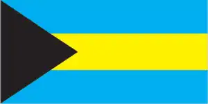
- The national symbols are blue marlin, flamingo, and Yellow Elderflower; the national colors: are aquamarine, yellow, and black.
- Internet TLD: .bs
The British-controlled volcanic archipelago of Bermuda comprises 150 smaller islands and reefs. The eight largest islands are connected by bridges and causeways and together makeup 95% of the archipelago’s total area of 21 km2. Bermuda is home to 63,000 people and receives half a million visitors. Also, a British outpost, Turks and Caicos, is ranked among the top 10 dive sites in the world. The Bahamas are a group of islands covering more than 250 000 km2, comprising some 700 islands and almost 2 500 small coral reefs (cays in English). The archipelago is located on the North American Rock Plate and contains one of the enormous limestone masses in the world. Most of the larger islands rising above the sea are over 150 km long but only a few kilometers wide. The Bahamas is a diver’s paradise and an ornithologist’s paradise. Its flamingo population is one of the largest on earth. Twelve national parks and protected areas have been created to preserve its unique wildlife.
The country’s extensive merchant fleet consists mainly of “flag-of-convenience” vessels registered by foreign owners.
Background
Lucayan Indians inhabited the islands when Christopher COLUMBUS first set foot in the New World in San Salvador in 1492. British settlement of the islands began in 1647. The islands became a colony in 1783. Piracy thrived in the 17th and 18th centuries because of The Bahamas’ proximity to shipping lanes. Since attaining independence from the UK in 1973, The Bahamas has prospered through tourism, international banking, and investment management, which comprise up to 85% of GDP. Because of its proximity to the US – the nearest Bahamian landmass being only 80 km (50 mi) from Florida – the country is a central transshipment point for illicit trafficking, particularly to the US mainland and Europe. US law enforcement agencies cooperate closely with The Bahamas, and the US Coast Guard assists Bahamian authorities in coastal defense through Operation Bahamas, Turks and Caicos, or OPBAT.
Geography
Long, mainly flat coral formations with a few low hills. Some islands have pine forests, lagoons, and mangrove swamps.
The Bahamas is one of the most important countries in the Caribbean and a member of the Commonwealth. It consists of more than 700 islands in the western Atlantic Ocean. It is a very diverse country with its own unique culture and customs.
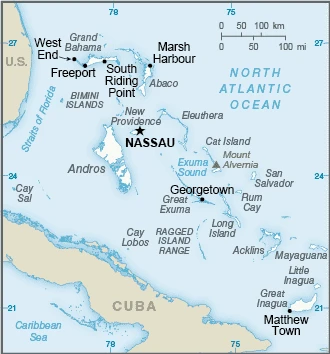
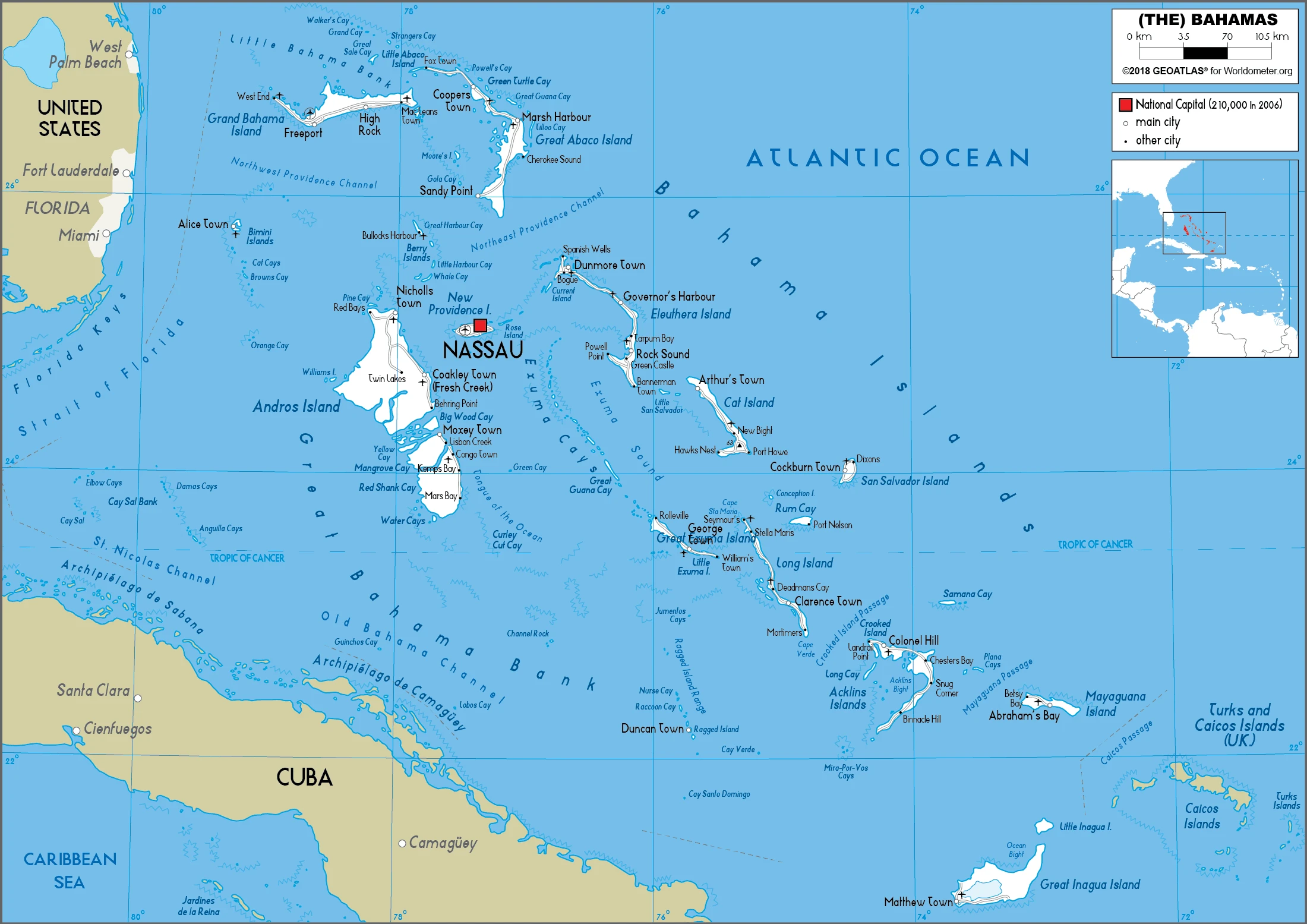
This state is located in a chain of islands in the North Atlantic Ocean, southeast of Florida, northeast of Cuba, under the coordinates of 24 15 N, 76 00 W, covering an area of 13,880 sq km with a coastline of 3,542 km. The Bahamas is Slightly smaller than Connecticut.
Long, flat coral formations with some low rounded hills, with 1.3 Km NE of old bight on cat island 64 m as the highest point of The Bahamas, while Atlantic Ocean 0 m as the lowest point. With a total of 13,880 sq km, The Bahamas has 10,010 sq km of land and 3,870 sq km of water surface area.
Strategic location adjacent to US and Cuba; extensive island chain of which 30 are inhabited.
The climate in The Bahamas is as follows: Tropical marine, moderated by warm waters of the gulf stream.
When you visit The Bahamas, the natural hazards shall be considered: Hurricanes and other tropical storms cause extensive flood and wind damage.
The following major health-threatening issues shall be considered when visiting The Bahamas: none.
Current environmental issues affecting the Bahamian people: coral reef decay; solid waste disposal.
Google Maps The Bahamas
The capital and other divisions
Capital city: Nassau found under the coordinates 25 05 N, 77 21 W, applying the time zone UTC-5 (same time as Washington, DC, during Standard Time), using the following daylight saving time: +1hr begins the second Sunday in March; ends first Sunday in November.
The capital, Nassau, is the largest city in the country of The Bahamas and also one of the most important ports in the Caribbean. One of the main attractions in Nassau is that it offers a great view of both Nassau Harbour and The Blue Lagoon. It’s a stunning view that has to be experienced to be believed.
The Bahamas became independent on 10 July 1973 (from the UK), and its national holiday is Independence Day, 10 July (1973).
Administrative divisions: 31 districts; Acklins Islands, Berry Islands, Bimini, Black Point, Cat Island, Central Abaco, Central Andros, Central Eleuthera, City of Freeport, Crooked Island and Long Cay, East Grand Bahama, Exuma, Grand Cay, Harbour Island, Hope Town, Inagua, Long Island, Mangrove Cay, Mayaguana, Moores Island, North Abaco, North Andros, North Eleuthera, Ragged Island, Rum Cay, San Salvador, South Abaco, South Andros, South Eleuthera, Spanish Wells, West Grand Bahama.
People and society
Over 60% of the population lives in New Providence. Tourism employs over half of the labor force. There are marked wealth disparities, from urban professionals in the banking sector to traditional fishers on outlying islands and illegal Haitian and Cuban immigrants. More women are now entering the professions. Government priorities are tackling narcotics trafficking and combating money laundering.
The population in The Bahamas is 352,655 (July 2021 estimate). Note: estimates for this country explicitly take into account the effects of excess mortality due to AIDS; this can result in lower life expectancy, higher infant mortality, higher death rates, lower population growth rates, and changes in the distribution of the population by age and sex than would otherwise be expected, with an average of 0.84% (2021 estimate) change. That means The Bahamas is the No. 178 in the world’s populated rank list. With an average of 32.8 years median age (31.7 years for males and 31.7 years for women), The Bahamas ranks No. 104 on the globe’s median age rank list.
The people living in this country are the Bahamian(s) (noun) or Bahamian (adjective) and belong mainly to the following ethnic groups: African descent 90.6%, White 4.7%, mixed 2.1%, other 1.9%, unspecified 0.7% (2010 estimate). Note: data represent population by racial group.
They speak English (official language), Creole (among Haitian immigrants) languages and practice the following religions: Protestant 69.9% (includes Baptist 34.9%, Anglican 13.7%, Pentecostal 8.9% Seventh Day Adventist 4.4%, Methodist 3.6%, Church of God 1.9%, Brethren 1.6%, other Protestant .9%), Roman Catholic 12%, other Christian 13% (includes Jehovahs Witness 1.1%), other 0.6%, none 1.9%, unspecified 2.6% (2010 estimate).
We can conclude the following about the population in The Bahamas: Most of the population lives in urban areas, with two-thirds living on the new providence island where Nassau is located. In The Bahamas, we are talking about 83.4% (2021) of the total population living in cities, and most of them reside in the following municipalities: 280,000 Nassau (capital city) (2018).
Industry
Major tourist destination, especially for US visitors. Financial services: banking and insurance.
The Bahamas has the second-highest per capita GDP in the English-speaking Caribbean, with an economy heavily dependent on tourism and financial services. Tourism accounts for approximately 50% of GDP and directly or indirectly employs half of the archipelago’s labor force. Financial services constitute the second-most important sector of the Bahamian economy, accounting for about 15% of GDP. Manufacturing and agriculture contribute less than 7% of GDP and show little growth, despite government incentives aimed at those sectors. The new government led by Prime Minister Hubert MINNIS has prioritized addressing fiscal imbalances and rising debt, which stood at 75% of GDP in 2016. Large capital projects like the Baha Mar Casino and Hotel are driving growth. Public debt increased in 2017 due to hurricane reconstruction and relief financing. The primary fiscal balance was a 0.4% of GDP deficit in 2016. The Bahamas is the only country in the Western Hemisphere that is not a member of the World Trade Organization.
The Bahamas is rich in the following natural resources: Salt, aragonite, timber, and arable land.
The main industrial sectors are tourism, banking, oil bunkering, maritime industries, transshipment and logistics, salt, aragonite, and pharmaceuticals.
The country’s export sectors are powerful in ships, refined petroleum, nitrogen compounds, crustaceans, and styrene polymers (2019), partnering with these nations: Poland 32%, United States 17%, Ecuador 9%, China 6%, Japan 5% (2019). The export trade resulted in $1.69 billion. Note: Data are in current year dollars (2020 estimate). In a global export rank, values resulted in The Bahamas’ position of 161.
Land use in The Bahamas: 51.4% (2018 estimate) forest, 47.2% (2018 estimate) other.
The arable land area is 0.8% (2018 estimate), and the agricultural land is 1.4% (2018 estimate). Land use for permanent crops 0.4% (2018 estimate), permanent pasture 0.2% (2018 estimate). The sum of the area of the irrigated land is 10 sq km (2012).
The main agro-industrial products of The Bahamas are sugar cane, grapefruit, vegetables, bananas, tomatoes, poultry, tropical fruit, oranges, coconuts, and mangoes/guavas.
The country typically needs to import: ships, refined petroleum, crude petroleum, recreational boats, and cars (2019), partnering with the following nations: the United States 31%, South Korea 29%, Japan 14% (2019) in a sum value of $3.64 billion. Note: data are in current year dollars (2020 estimate) $4.91 billion. Note: data are in current year dollars (2019 estimate) $5.12 billion. Note: data are in current year dollars (2018 estimate). This sum value on the global ranking list of imports resulted in The Bahamas 154.
The Bahamas Driving Directions
In this post, you learned about The Bahamas, a chain of islands in the North Atlantic Ocean, southeast of Florida and northeast of Cuba. We published some basic information about its capital Nassau, and the Bahamian nation.
Are you interested in visiting The Bahamas and looking for driving directions? Click here to plan your route, or see a printable road map of The Bahamas below for an overview of the route network.
Printable map of The Bahamas
Did you know about the Bahamas?
If you’re looking for a place to escape the cold winter weather, the Bahamas may be what you’re looking for. The country is known for its crystal clear waters and beautiful white-sand beaches. And if that’s not enough, the Bahamas also offers plenty of activities and attractions to keep you busy. From shopping at the luxury malls to exploring the many UNESCO World Heritage Sites, there’s something for everyone in the Bahamas.
The Bahamas were once the home of Christopher Columbus and Queen Isabella. The islands were also the site of one of the bloodiest battles in history – the Battle of Nassau. Today, the Bahamas is a popular tourist destination for those looking for relaxation and peace.
After virtually visiting The Bahamas, you may also be interested in the neighboring countries: none.
If you liked our Google map and The Bahamas information page,
please share it with others or save the link https://www.drivingdirections.net in your bookmarks.