
Bolivia Google Maps is a site/tool that offers a wide range of map views (topographic, satellite, street view) and navigation options, with little effort on your part, yet efficiently. If you need to plan a trip to a new place like Bolivia, Google maps are available on desktop, mobile, or tablet. This Google maps and information page is dedicated to Bolivia, South America (13 countries), showing its location, country facts, details about its capital city La Paz (administrative capital); Sucre (constitutional legislative and judicial capital), bordering countries like Argentina, Brazil, Chile, Paraguay, Peru, and plenty of other information which may be interesting when you visit this South American state.
Quick links: Google Maps Bolivia, La Paz (administrative capital), Sucre (constitutional legislative and judicial capital) Google maps, Driving Directions Bolivia, Printable Road Map.
About Bolivia in a nutshell
- Between 1825 and 1982 Bolivia averaged more than one armed coup a year.
- Conventional short form of the name: Bolivia
- The conventional long form of the name: Plurinational State of Bolivia
- Local long form: Estado Plurinacional de Bolivia
- Local short form: Bolivia
- Former name(s): N/A
- Etymology: the country is named after Simon BOLIVAR, a 19th-century leader in the South American wars for independence.
- The legal system in Bolivia: civil law system with influences from Roman, Spanish, canon (religious), French, and indigenous law.
- Climate: Altiplano has extreme tropical climate, with night-frost in winter. North and east are hot and humid.
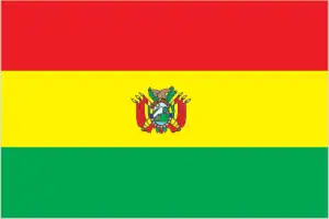
- The national symbols are llama, Andean condor, two national flowers: the cantuta and the patuju; national colors: red, yellow, green.
- Internet TLD: .bo
Sparsely populated, with highly varied topography and climate, isolated from the sea, Bolivia’s World Heritage sites range from the arid highlands of the arid Altiplano to the Amazon rainforest. The ruined city of Tiahuanaco preserves the remains of the Ajmara civilization that flourished around Lake Titicaca between 500 and 900 AD.
Fuerte de Samaipata may have been the religious center of a highly developed mystery culture in the 14th to 16th centuries AD, with geometric carvings and animal motifs unique in the Americas. Tucked away on the edge of the Altiplano, Potosí is the highest city on Earth, and its silver mine was the world’s largest industrial center in the 16th and 17th centuries.
Founded by the Spanish in 1538 as Ciuda de La Plata de Nuovo Toledo, Sucre became the first capital of independent Bolivia in the 19th century and was renamed in honor of Antonio Jósé de Sucre, the state’s first president. The Jesuit missions of Chiquitos were established at the end of the 17th century and operated for half a century: the ruins of six mission colonies remain. The Noel Kempff Mercado National Park is one of the largest, most pristine, and diverse protected habitats in the Amazon.
Background
Bolivia, named after independence fighter Simon BOLIVAR, broke away from Spanish rule in 1825. Much of its subsequent history has consisted of coups and countercoups, with the last coup occurring in 1978. Democratic civilian rule was established in 1982, but leaders have faced complex deep-seated poverty, social unrest, and illegal drug production.
In December 2005, Bolivians elected Movement Toward Socialism leader Evo MORALES president – by the widest margin of any leader since the restoration of civilian rule in 1982 – after he promised to change the country’s traditional political class empower the nations poor, indigenous majority. In December 2009 and October 2014, President MORALES easily won reelection. His party maintained control of the legislative branch of the government, which has allowed him to continue his process of change.
In February 2016, MORALES narrowly lost a referendum to approve a constitutional amendment that would have allowed him to compete in the 2019 presidential election. However, a 2017 Supreme Court ruling stating that term limits violate human rights justified MORALES to choose his party to run again in 2019. MORALES attempted to claim victory in the 20 October 2019 election, but widespread allegations of electoral fraud, rising violence, and pressure from the military ultimately forced him to flee the country. An interim government, led by President Jeanine ANEZ Chavez, prepared new elections on 18 October 2020.
Geography
Bolivia has some of the most beautiful landscapes in the world. There are deep valleys, rugged mountains, and immense dunes. You can find volcanoes, lakes, waterfalls, lush tropical forests, and more. Bolivia is a high windswept plateau, the Altiplano, lies between two Andean mountain ranges. Semiarid grasslands to the east; dense tropical forests to the north.
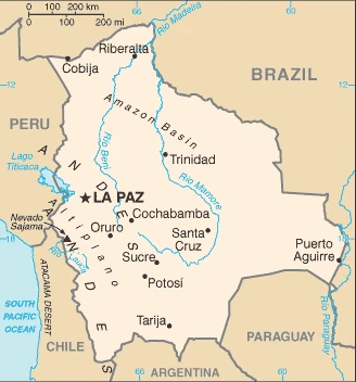
Landlocked high in central South America, Bolivia is one of the regions poorest countries. La Paz is the worlds highest capital city: 13,385 feet (3631 m) above sea level.
This state is located in Central South America, southwest of Brazil, under the coordinates of 17 00 S, 65 00 W, covering an area of 1,098,581 sq km with a coastline of 0 km (landlocked country). Bolivia is Slightly less than three times the size of Montana.
Bolivia has 7,252 km of land boundaries in total, and bordering with (5 nations): Argentina 942 km, Brazil 3403 km, Chile 942 km, Paraguay 753 km, Peru 1212 km.
Rugged Andes mountains with a highland plateau (Altiplano), hills, lowland plains of the Amazon basin, with Nevado Sajama 6,542 m as the highest point of Bolivia, while Rio Paraguay 90 m as the lowest point, causing a mean elevation at 1,192 m throughout the country. With a total of 1,098,581 sq km, Bolivia has 1,083,301 sq km of land and 15,280 sq km water surface area.
Major water bodies in the country: Lago Titicaca (shared with Peru) – 8,030 sq km (a freshwater lake), Lago Poopo – 1,340 sq km (saltwater lake) while the major rivers are: Rio de la Plata/Parana (shared with Brazil, Argentina, Paraguay, and Uruguay) – 4,880 km. The significant watersheds for Bolivia are Atlantic Ocean drainage: Amazon (6,145,186 sq km) Paraná (2,582,704 sq km).
Landlocked; shares control of Lago Titicaca, the world’s highest navigable lake (elevation 3,805 m), with Peru.
The climate in Bolivia is as follows: Varies with altitude, humid and tropical to cold and semiarid.
When you visit Bolivia, the natural hazards shall be considered: Flooding in the northeast (March to April), volcanism: volcanic activity in Andes mountains on the border with chile; historically active volcanoes in this region are Irruputuncu (5,163 m), which last erupted in 1995, and the olca-paruma volcanic complex (5,762 m to 5,167 m).
The following major health-threatening issues shall be considered when visiting Bolivia: degree of risk: very high (2020), bacterial diarrhea and hepatitis A, dengue fever, and malaria.
Current environmental issues affecting the Bolivian people: the clearing of land for agricultural purposes and the international demand for tropical timber are contributing to deforestation; soil erosion from overgrazing and poor cultivation methods (including slash-and-burn agriculture); desertification; loss of biodiversity; industrial pollution of water supplies used for drinking and irrigation.
Google Maps Bolivia
The capital and other divisions
Capital city: La Paz (administrative capital); Sucre (constitutional legislative and judicial capital) found under the coordinates 16 30 S, 68 09 W, applying the time zone UTC-4 (1 hour ahead of Washington, DC, during Standard Time), using the following daylight saving time: none.
La Paz is the capital and largest city of Bolivia, located in the westernmost La Paz Department, on the eastern slopes of the Andes. It is also the most populous city in Bolivia, with a population estimated at 2 million.
Bolivia became independent on 6 August 1825 (from Spain), and its national holiday is Independence Day, 6 August (1825).
Administrative divisions: 9 departments (departamentos, singular – departamento); Beni, Chuquisaca, Cochabamba, La Paz, Oruro, Pando, Potosi, Santa Cruz, Tarija.
People and society
Wealthy Spanish-descended families have traditionally controlled the economy. The indigenous majority faces widespread discrimination. Amerindian Evo Morales, president from 2005, is cutting poverty, redistributing land, and pushing for international recognition of legal coca use.
The population in Bolivia is 11,758,869 (July 2021 estimate), with an average of 1.39% (2021 estimate) change. That means Bolivia is the No. 81 in the world’s populated rank list. With an average of 25.3 years median age (24.5 years for males and 24.5 years for women), Bolivia ranks No. 160 on the globe’s median age rank list.
The people living in this country are the Bolivian(s) (noun) or Bolivian (adjective) and belong mainly to the following ethnic groups: Mestizo (mixed white and Amerindian ancestry) 68%, Indigenous 20%, White 5%, Cholo/Chola 2%, African descent 1%, other 1%, unspecified 3%; 44% of respondents indicated feeling part of some indigenous group, predominantly Quechua or Aymara (2009 estimate). Note: results among surveys vary based on the wording of the ethnicity question and the available response choices; the 2001 national census did not provide Mestizo as a response choice, resulting in a much higher proportion of respondents identifying themselves as belonging to one of the available indigenous ethnicity choices; the use of Mestizo and Cholo varies among response choices in surveys, with surveys using the terms interchangeably, providing one or the other as a response choice, or providing the two as different response choices.
They speak Spanish (official language) 60.7%, Quechua (official language) 21.2%, Aymara (official language) 14.6%, Guarani (official language) 0.6%, other native languages 0.4%, foreign languages 2.4%, none 0.1%; languages and practice the following religions: Roman Catholic 70%, Evangelical 14.5%, Adventist 2.5%, Church of Jesus Christ 1.2%, agnostic 0.3%, atheist 0.8%, other 3.5%, none 6.6%, unspecified 0.6% (2018 estimate).
We can conclude the following about the population in Bolivia: A high altitude plain in the west between two cordilleras of the Andes, known as the Altiplano, is the focal area for most of the population. A dense settlement pattern is also found in and around Santa Cruz, located on the eastern side of the Andes. In Bolivia, we are talking about 70.5% (2021) of the total population is living in cities, and most of them reside in the following municipalities: 278,000 Sucre (Constitutional Capital) (2018); 1.882 million, La Paz (capital city), 1.749 million, Santa Cruz, 1.337 million, Cochabamba (2021).
Industry
Gold, silver, zinc, tin, oil, and natural gas are all vulnerable to world price fluctuations. Social issues and the nationalization of the natural gas sector deter investors. Major cocoa producer. Lack of manufacturing. Rich eastern provinces want autonomy.
Bolivia is a resource-rich country with strong growth attributed to captive markets for natural gas exports to Brazil and Argentina. However, the country remains one of the least developed countries in Latin America because of state-oriented policies that deter investment. Following an economic crisis during the early 1980s, reforms in the 1990s spurred private investment, stimulated economic growth, and cut poverty rates. The period 2003-05 was characterized by political instability, racial tensions, and violent protests against plans – subsequently abandoned – to export Bolivia’s newly discovered natural gas reserves to large Northern Hemisphere markets.
In 2005-2006, the government passed hydrocarbon laws that imposed significantly higher royalties and required foreign firms then operating under risk-sharing contracts to surrender all production to the state energy company in exchange for a predetermined service fee; the laws engendered much public debate. High commodity prices between 2010 and 2014 sustained rapid growth and large trade surpluses, with GDP growing 6.8% in 2013 and 5.4% in 2014. The global decline in oil prices that began in late 2014 exerted downward pressure on Bolivia’s price for exported gas. It resulted in lower GDP growth rates – 4.9% in 2015 and 4.3% in 2016 – and losses in government revenue and fiscal and trade deficits.
A lack of foreign investment in the key sectors of mining and hydrocarbons, along with conflict among social groups, pose challenges for the Bolivian economy. In 2015, President Evo MORALES expanded efforts to court international investment and boosted Bolivias energy production capacity. MORALES passed an investment law and promised not to nationalize other industries to improve the investment climate. In early 2016, the Government of Bolivia approved the 2016-2020 National Economic and Social Development Plan to maintain the growth of 5% and reduce poverty.
Bolivia is rich in the following natural resources: Tin, natural gas, petroleum, zinc, tungsten, antimony, silver, iron, lead, gold, timber, hydropower.
The main industrial sectors are mining, smelting, electricity, petroleum, food, beverages, handicrafts, clothing, and jewelry.
The country’s export sectors are particularly strong in natural gas, gold, zinc, soybean oil, and soy products, tin, silver, lead (2019), partnering with these nations: Argentina 16%, Brazil 15%, United Arab Emirates 12%, India 10%, United States 6%, South Korea 5%, Peru 5%, Colombia 5% (2019). The export trade resulted in $7.55 billion. Note: Data are in current year dollars (2020 estimate). In a global rank of the export, values resulted in Bolivia’s position of 111.
Land use in Bolivia: 52.5% (2018 estimate) forest, 13.2% (2018 estimate) other.
The arable land area is 3.6% (2018 estimate), and the agricultural land is 34.3% (2018 estimate). Land use for permanent crops 0.2% (2018 estimate), permanent pasture 30.5% (2018 estimate). The sum of the area of the irrigated land is 3,000 sq km (2012).
The main agro-industrial products of Bolivia are sugar cane, soybeans, potatoes, maize, sorghum, rice, milk, plantains, poultry, bananas.
The country typically needs to import: cars, refined petroleum, delivery trucks, iron, buses (2019), partnering with the following nations: Brazil 22%, Chile 15%, China 13%, Peru 11%, Argentina 8%, United States 7% (2017) in a sum value of $8.27 billion. Note: data are in current year dollars (2020 estimate) $11.95 billion. Note: data are in current year dollars (2019 estimate) $12.44 billion. Note: data are in current year dollars (2018 estimate). This sum value on the global ranking list of imports resulted in Bolivia 117.
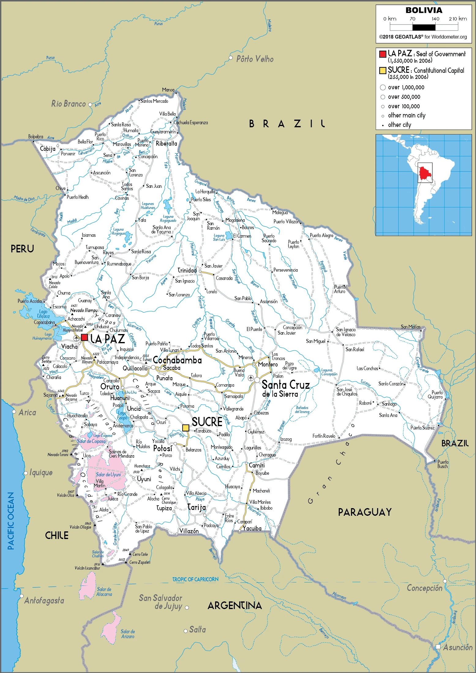
Bolivia Driving Directions
In this post, you learned about Bolivia, Central South America, southwest of Brazil. We published some basic information about its capital La Paz (administrative capital), Sucre (constitutional legislative and judicial capital), and the Bolivian nation.
Are you interested in visiting Bolivia and looking for driving directions? Click here to plan your route, or see a printable road map of Bolivia below for an overview of the route network.
Printable map of Bolivia
Did you know about Bolivia?
Bolivia is also known for having some of the best-preserved natural areas on Earth. These include some of the most diverse combinations of plant and animal species on the planet.
After virtually visiting Bolivia, you may also be interested in the neighboring countries: Argentina, Brazil, Chile, Paraguay, Peru.
If you liked our Google map and Bolivia information page,
please share it with others or save the link https://www.drivingdirections.net in your bookmarks.