
Bouvet Island Google Maps is a site/tool that offers a wide range of map views (topographic, satellite, street view) and navigation options, with little effort on your part, yet efficiently. If you need to plan a trip to a new place like Bouvet Island, Google maps are available on desktop, mobile, or tablet. This Google maps and information page is dedicated to Bouvet Island, Antarctic Region (4 countries), showing its location, country facts, and plenty of other information which may be interesting when you visit this Antarctic state.
Quick links: Google Maps Bouvet Island, Driving Directions Bouvet Island, Printable Map.
About Bouvet Island in a nutshell
- Conventional short form of the name: Bouvet Island
- The conventional long form of the name: none
- Etymology: named after the French naval officer Jean-Baptiste Charles BOUVET who discovered the island in 1739.
- The legal system in Bouvet Island: the laws of Norway apply where applicable.
- Climate: Antarctic.
- The national symbols are N/A.
- Internet TLD: .bv
Bouvet Island is a Norwegian uninhabited protected nature reserve. As a subantarctic volcanic island, it’s situated in the South Atlantic Ocean (54°25′S 3°22′E). It is not part of the southern region covered by the Antarctic Treaty. The island lies 1,700 kilometers away from the Princess Astrid Coast of Queen Maud Land, Antarctica, 1,900 kilometers from the South Sandwich Islands, 1,600 kilometers from Gough Island, and 2,600 kilometers from the coast of South Africa.
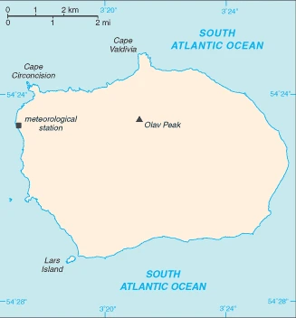
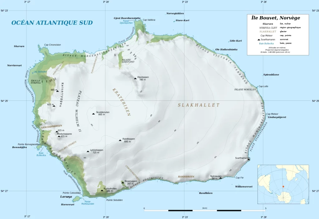
The island is 49 square kilometers (19 sq mi) in size, with 93% of its surface covered by glaciers. The center of the island features a crater created by an inactive volcano. It has one other island, Larsøya, along its coast. Nyrøysa is the only easy spot to land and houses a weather station.
Background
This uninhabited, volcanic, Antarctic island is almost entirely covered by glaciers making it difficult to approach. It is recognized as the most remote island on Earth. (It is furthest in the distance from any other point of land, 1,639 km from Antarctica.) Bouvet Island was discovered in 1739 by a French naval officer after whom it is named. No claim was made until 1825 when the British flag was raised. A few expeditions visited the island in the late 19th century. In 1929, the UK waived its claim in favor of Norway, which had previously occupied the island.
In 1971, Norway designated Bouvet Island and a nature reserve adjacent territorial waters. Since 1977, Norway has run an automated meteorological station and studied foraging strategies and distribution of fur seals and penguins on the island. In February 2006, an earthquake weakened the station’s foundation causing it to be blown out to sea in a winter storm. Norway erected a new research station in 2014 that can hold six people for periods of two to four months.
Geography
Bouvet Island is a tiny island in the South Atlantic Ocean. It is part of Norway but sits close to Antarctica. The island has been inhabited since 1827 and has been a French possession since 1927.
This state is located on an island in the South Atlantic Ocean, southwest of the Cape of Good Hope (South Africa), under the coordinates of 54 26 S, 3 24 E, covering an area of 49 sq km with a coastline of 29.6 km. Bouvet Island is About 0.3 times the size of Washington, DC.
The volcanic coast is primarily inaccessible, with Olavtoppen (Olav peak) 780 m as the highest point of Bouvet Island, while South Atlantic Ocean 0 m as the lowest point. With a total of 49 sq km, Bouvet Island has 49 sq km of land and 0 sq km water surface area.
Almost entirely covered by glacial ice (93%), declared a nature reserve by Norway; the distance from Bouvet Island to Norway is 12,776 km, which is almost one-third the circumference of the Earth.
The climate in Bouvet Island is as follows: Antarctic.
When you visit Bouvet Island, the natural hazards shall be considered: Occasional volcanism, rock slides, harsh climate, surrounded by pack ice in winter.
None of the following major health-threatening issues shall be considered when visiting Bouvet Island.
Current environmental issues affecting the people: none, and almost entirely ice-covered.
Google Maps Bouvet Island
The capital and other divisions
Bouvet Island is an uninhabited volcanic island located at the bottom of the western side of the South Atlantic Ocean. It is considered one of the most remote islands in the world. It is a territory of France and part of Antarctica. The highest point on Bouvet Island is Mount Sidley, at 795 meters above sea level. Still, it has no permanent residents due to extreme weather conditions, lack of freshwater, and other factors.
People and society
The population in Bouvet Island is uninhabited, with an average of 0% change.
Industry
No economic activity; declared a nature reserve.
Bouvet Island is rich in the following natural resources: None.
The main industrial sectors are typically none.
Land use in Bouvet Island: 0% (2018 estimate) forest, 100% (2018 estimate) other.
The arable land area is 0% (2018 estimate), and the agricultural land is 0% (2018 estimate). Land use for permanent crops 0% (2018 estimate), permanent pasture 0% (2018 estimate).
Bouvet Island Driving Directions
In this post, you learned about Bouvet Island, an island in the South Atlantic Ocean, southwest of the Cape of Good Hope (South Africa).
Are you interested in visiting Bouvet Island and looking for driving directions? Click here to plan your route, or see a printable road map of Bouvet Island below for an overview of the route network.
Printable map of Bouvet Island
Did you know about Bouvet Island?
Bouvet Island is the most remote island on Earth. It’s located in the South Atlantic Ocean, about 1800 kilometers from Antarctica. There’s nothing more than a few rocks and some penguins living on this island. The nearest land is Princess Astrid Coast of Queen Maud Land, Antarctica, about 740 miles away. It’s also known as “Bouvetoya” or “Bouvetøya”.
After virtually visiting Bouvet Island, you may also be interested in the neighboring places: Antarctic, Norway, South Africa.
If you liked our Google map and Bouvet Island information page,
please share it with others or save the link https://www.drivingdirections.net in your bookmarks.