
Cocos Islands Google Maps is a site/tool that offers a wide range of map views (topographic, satellite, street view) and navigation options, with little effort on your part, yet efficiently. If you need to plan a trip to a new place like Cocos Islands, Google maps are available on desktop, mobile, or tablet. This Google maps and information page is dedicated to Cocos Islands, Southeast Asia (19 countries), showing its location, country facts, details about its capital city West Island, bordering countries like none, and plenty of other information which may be interesting when you visit this Southeastern Asian state.
Quick links: Google Maps Cocos Islands, West Island Google maps, Driving Directions Cocos Islands, Printable Road Map.
About Cocos Islands in a nutshell
- Conventional short form of the name: Cocos (Keeling) Islands
- The conventional long form of the name: Territory of Cocos (Keeling) Islands
- Etymology: the name refers to the abundant coconut trees on the islands and to English Captain William KEELING, the first European to sight the islands in 1609.
- The legal system in Cocos Islands: common law based on the Australian model.
- Climate: Tropical with high humidity, moderated by the southeast trade winds for about nine months of the year.
- The national symbols are none.
- Internet TLD: .cc
Background
British captain William KEELING discovered Cocos (Keeling) Islands in 1609, and they were named Cocos Islands in 1622 for their coconut trees. Some maps began referring to them as the Keeling Islands in 1703. In 1825, Scottish trader John CLUNIES-ROSS tried to get to Christmas Island but was blown off-course and landed on Cocos (Keeling) Islands. The following year, a British trader hired Johns’s brother to bring enslaved people and a harem of Malay women to create the first permanent settlement on the island. By the 1830s, the Clunies-Ross family had firmly established themselves as the islands’ leaders, and they ruled Cocos (Keeling) Islands in a feudal style until 1978.
The UK annexed the islands in 1857 and administered them from Ceylon after 1878 and from Singapore after 1886. Cocos (Keeling) Islands hosted a cable relaying station and attacked the Germans in World War I. The Japanese similarly attacked the islands in World War II. The UK transferred the islands to Australia in 1955, which officially named the islands the Cocos (Keeling) Islands. In 1978, Australia bought all the land held by the Clunies-Ross family, ending their control of the island’s governance. In a referendum in 1984, most islanders voted to integrate with Australia, and Western Australian laws have applied on the islands since 1992.
Colombia was one of the three countries that emerged after the dissolution of Gran Colombia in 1830 (the others are Ecuador and Venezuela). A decades-long conflict between government forces, paramilitaries, and antigovernment insurgent groups heavily funded by the drug trade, principally the Revolutionary Armed Forces of Colombia (FARC), escalated during the 1990s. More than 31,000 former United Self Defense Forces of Colombia (AUC) paramilitaries were demobilized by the end of 2006, and the AUC as a formal organization ceased to operate. In the wake of the paramilitary demobilization, illegal armed groups arose, whose members included some former paramilitaries. After four years of formal peace negotiations, the Colombian Government signed a final peace accord with the FARC in November 2016, subsequently ratified by the Colombian Congress.
The accord calls for members of the FARC to demobilize, disarm, and reincorporate into society and politics. The accord also committed the Colombian Government to create three new institutions to form a comprehensive system for truth, justice, reparation, and non-repetition, to include a truth commission, a particular unit to coordinate the search for those who disappeared during the conflict, and a Special Jurisdiction for Peace to administer justice for conflict-related crimes. The Colombian Government has stepped up efforts to expand its presence into every one of its administrative departments. Despite decades of internal conflict and drug-related security challenges, Colombia maintains relatively strong democratic institutions characterized by peaceful, transparent elections and the protection of civil liberties.
Geography
Located on the edge of the Indian Ocean, Cocos Islands enjoy a pleasant climate and are home to rich vegetation. Despite being only inhabited by around 2,000 people, they are famous for their coral reefs and turtles.
This state is located in Southeastern Asia, a group of islands in the Indian Ocean, southwest of Indonesia, about halfway between Australia and Sri Lanka, under the coordinates of 12 30 S, 96 50 E, covering an area of 14 sq km with a coastline of 26 km. Cocos Islands is About 24 times the mall’s size in Washington, DC.
Flat, low-lying coral atolls, with South point on south island 9 m as the highest point of Cocos Islands, while Indian Ocean 0 m. With a total of 14 sq km, Cocos Islands has 14 sq km of land and 0 sq km water surface area.
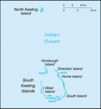
There are 27 coral islands in the group; apart from North Keeling Island, which lies 30 km north of the leading group, the islands form a horseshoe-shaped atoll surrounding a lagoon; North Keeling Island was declared a national park in 1995 and is administered by Parks Australia; the population on the two inhabited islands generally is split between the ethnic Europeans on West Island and the ethnic Malays on Home Island; the islands are thickly covered with coconut palms and other vegetation.
The climate in Cocos Islands is as follows: Tropical with high humidity, moderated by the southeast trade winds for about nine months of the year.
The natural hazards shall be considered when you visit Cocos Islands: Cyclone season is October to April.
The following major health-threatening issues shall be considered when visiting Cocos Islands: none.
Current environmental issues affecting the Cocos Islander people: freshwater resources are limited to rainwater accumulations in natural underground reservoirs; illegal fishing is a concern.
Google Maps Cocos Islands
The capital and other divisions
Capital city: West Island found under the coordinates 12 10 S, 96 50 E, applying the time zone UTC+6.5 (11.5 hours ahead of Washington, DC, during Standard Time), using the following daylight saving time: none.
Cocos Islands is the capital of West Island, a country divided into two islands located in the northern archipelago of Costa Rica. There are many stories about its creation, but one can be confident that this tiny country was built due to solid willpower and determination.
Cocos Islands became independent on none (territory of Australia), and its national holiday is Australia Day (commemorates the arrival of the First Fleet of Australian settlers), 26 January (1788).
Administrative divisions: none (territory of Australia).
People and society
The population in Cocos Islands is 596 (July 2014 estimate). That means Cocos Islands is the No. 236 in the world’s populated rank list.
The people living in this country are the Cocos Islander(s) (noun) or Cocos Islander (adjective) and belong mainly to the following ethnic groups: Europeans, Cocos Malays.
They speak Malay (Cocos dialect) 68.8%, English 22.3%, unspecified 8.9% languages and practice the following religions: Muslim (predominantly Sunni) 75%, Anglican 3.5%, Roman Catholic 2.2%, none 12.9%, unspecified 6.3% (2016 estimate).
We can conclude the following about the population in Cocos Islands: Only home island and west island are populated.
Industry
Coconuts, grown throughout the islands, are the sole cash crop. Small local gardens and fishing contribute to the food supply, but other food and most other necessities must be imported from Australia. There is a small tourist industry.
Cocos Islands is rich in the following natural resources: Fish.
The main industrial sectors are typically copra products tourism.
The country’s export sectors are particularly strong in computers, packaged medicines, precious metal watches, office machinery/parts, chemical analysis instruments (2019), partnering with these nations: the United States 57%, Ireland 15% (2019). The export trade resulted in N/A.
Land use in Cocos Islands: 0% (2018 estimate) forest, 100% (2018 estimate) other.
The main agro-industrial products of Cocos Islands are vegetables, bananas, pawpaws, coconuts.
The country typically needs to import: gold, x-ray equipment, cars, prefabricated buildings, packaged medicines (2019), partnering with the following nations: Australia 73%, United Arab Emirates 15%, Netherlands 5% (2019).
Cocos Islands Driving Directions
In this post, you learned about Cocos Islands, Southeastern Asia, a group of islands in the Indian Ocean, southwest of Indonesia, about halfway between Australia and Sri Lanka. We published some basic information about its capital West Island, and the Cocos Islander nation.
Are you interested in visiting Cocos Islands and looking for driving directions? Click here to plan your route, or see a printable road map of Cocos Islands below for an overview of the route network.
Printable map of Cocos Islands

Did you know about Cocos Islands?
Cocos Islands is a small and remote island. It was an important trade hub in the 17th and 18th centuries, but travelers mainly visit it seeking unspoiled natural beauty today. Cocos Island is considered one of the most biodiverse ecosystems on Earth.
The area is famous for several reasons: watching ships go by, snorkeling or diving, exploring sunken RMS Titanic shipwrecks, and other pleasures like fishing or swimming.
After virtually visiting Cocos Islands, you may also be interested in the neighboring countries: none.
If you liked our Google map and Cocos Islands information page,
please share it with others or save the link https://www.drivingdirections.net in your bookmarks.