
El Salvador Google Maps is a site/tool that offers a wide range of map views (topographic, satellite, street view) and navigation options, with little effort on your part, yet efficiently. If you need to plan a trip to a new place like El Salvador, Google maps are available on desktop, mobile, or tablet. This Google maps and information page is dedicated to El Salvador, Central America, and the Caribbean (35 countries), showing its location, country facts, details about its capital city San Salvador, bordering countries like Guatemala, Honduras, and plenty of other information which may be interesting when you visit this Central American and the Caribbean state.
Quick links: Google Maps El Salvador, San Salvador Google maps, Driving Directions El Salvador, Printable Road Map.
About El Salvador in a nutshell
- Independent since 1841, El Salvador is named after Jesus Christ, “the savior” of Christians.
- Conventional short form of the name: El Salvador
- The conventional long form of the name: Republic of El Salvador
- Local long form: Republica de El Salvador
- Local short form: El Salvador
- Former name(s): N/A
- Etymology: name is an abbreviation of the original Spanish conquistador designation for the area Provincia de Nuestro Senor Jesus Cristo, el Salvador del Mundo (Province of Our Lord Jesus Christ, the Saviour of the World), which became simply El Salvador (The Savior).
- The legal system in El Salvador: civil law system with minor common law influence; judicial review of legislative acts in the Supreme Court.
- Climate: Tropical coastal belt is very hot, with seasonal rains. Cooler, temperate in highlands.
- The national symbols are turquoise-browed motmot (bird); national colors: blue, white.
- Internet TLD: .sv
Background
El Salvador achieved independence from Spain in 1821 and the Central American Federation in 1839. A 12-year civil war, which cost about 75,000 lives, was brought to a close in 1992 when the government and leftist rebels signed a treaty that provided military and political reforms. El Salvador is beset by one of the world’s highest homicide rates and pervasive criminal gangs.
Geography
El Salvador is a narrow coastal belt backed by two mountain ranges. There is a central plateau. The country is located within a seismic zone, and there are more than 20 volcanic peaks.
El Salvador is Central Americas smallest and most densely populated country. Already struggling to recover from a civil war in the 1980s, it was severely struck by earthquakes in 2001.
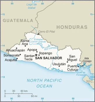
This state is located in Central America, bordering the North Pacific Ocean, between Guatemala and Honduras, under the coordinates of 13 50 N, 88 55 W, covering an area of 21,041 sq km with a coastline of 307 km. El Salvador is About the same size as New Jersey.
El Salvador has 590 km of land boundaries in total and borders with (2 nations): Guatemala 199 km, Honduras 391 km.
Primarily mountains with a narrow coastal belt and central plateau, with Cerro el Pital 2,730 m as the highest point of El Salvador, while Pacific Ocean 0 m as the lowest point, causing a mean elevation at 442 m throughout the country. With a total of 21,041 sq km, El Salvador has 20,721 sq km of land and 320 sq km of water surface area.
The smallest Central American country and only one without a coastline on the Caribbean Sea
The climate in El Salvador is as follows: Tropical, rainy season (May to October), dry season (November to April), tropical on coast, temperate in uplands.
When you visit El Salvador, the natural hazards shall be considered: Known as the land of volcanoes; frequent and sometimes destructive earthquakes and volcanic activity; extremely susceptible to hurricanes volcanism: significant volcanic activity; San Salvador (1,893 m), which last erupted in 1917, has the potential to cause significant harm to the country’s capital, which lies just below the volcanos Slopes; San Miguel (2,130 m), which last erupted in 2002, is one of the most active volcanoes in the country; other historically active volcanoes include Conchaguita, Ilopango, Izalco, and Santa Ana.
The following major health-threatening issues shall be considered when visiting El Salvador: degree of risk: high (2020), bacterial and protozoal diarrhea, dengue fever.
Current environmental issues affecting the Salvadoran people: deforestation, soil erosion; water pollution; contamination of soils from the disposal of toxic wastes.
Google Maps El Salvador
The capital and other divisions
Capital city: San Salvador found under the coordinates 13 42 N, 89 12 W, applying the time zone UTC-6 (1 hour behind Washington, DC, during Standard Time), using the following daylight saving time: none.
San Salvador is a city in northern El Salvador, which holds a prominent place in the country’s history. In the early years of its discovery, it was known as Ciudad Blanca (the White City) due to the whitewashed buildings that made up its Central Square. Later on, Spanish immigrants called it Ciudad Leona Victoria (the City of Leonora Victoria), and San Salvador was officially founded on February 2nd, 1538, by Spanish conquistador Pedro de Alvarado.
El Salvador became independent on September 15th, 1821 (from Spain), and its national holiday is Independence Day, September 15th (1821).
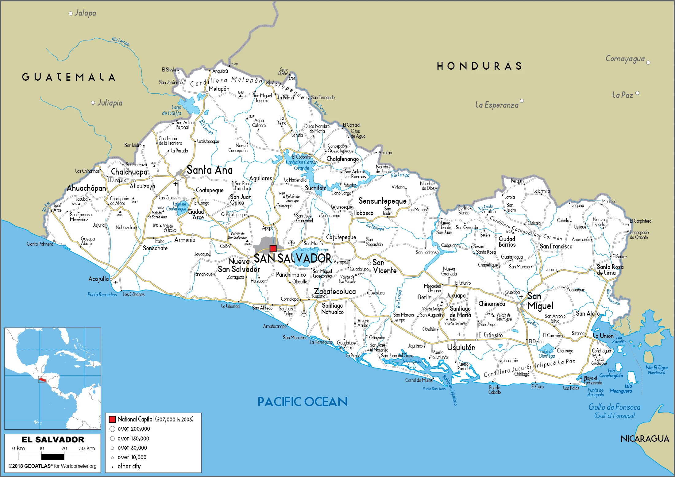
Administrative divisions: 14 departments (departamentos, singular – departamento); Ahuachapan, Cabanas, Chalatenango, Cuscatlan, La Libertad, La Paz, La Union, Morazan, San Miguel, San Salvador, San Vicente, Santa Ana, Sonsonate, Usulutan.
People and society
Ethnic tensions are few. Economic disparities sparked the 19811991 civil war between the US-backed government and left-wing FMLN guerrillas; 75,000 people died, many unarmed civilians, and widespread human rights abuses. In 2009 the FMLN won the presidency, but wealth disparities still exist despite some reform. Gangs now control much of daily life; the murder rate rises again despite a 2012 truce.
The population in El Salvador is 6,528,135 (July 2021 estimate), with an average of 0.67% (2021 estimate) change. That means El Salvador is the No. 109 in the world’s populated rank list. With an average of 27.7 years median age (26.2 years for males and 26.2 years for women), El Salvador ranks No. 145 on the globe’s median age rank list.
The people living in this country are the Salvadoran(s) (noun) or Salvadoran (adjective) and belong mainly to the following ethnic groups: Mestizo 86.3%, White 12.7%, Amerindian 0.2% (includes Lenca, Kakawira, Nahua-Pipil), Black 0.1%, other 0.6% (2007 estimate).
They speak Spanish (official language) Nawat (among some Amerindians) languages and practice the following religions: Roman Catholic 50%, Protestant 36%, other 2%, none 12% (2014 estimate).
We can conclude the following about the population in El Salvador: Although it is the smallest country in land area in Central America, El Salvador has a population that is 18 times larger than Belize. At least 20% of the population lives abroad. High population density country-wide, with particular concentration around the capital of San Salvador. In El Salvador, we are talking about 74.1% (2021) of the total population is living in cities, and most of them reside in the following municipalities: 1.107 million, San Salvador (capital city) (2021).
Industry
Coffee, sugar. Garment industry. Overseas remittances. Frequent natural disasters damage infrastructure and deepen the countrys reliance on aid. Most businesses suffer extortion by gangs. Violence deters investors and tourism.
The smallest country in Central America geographically, El Salvador has the fourth-largest economy. With the global recession, real GDP contracted in 2009, and economic growth has since remained low, averaging less than 2% from 2010 to 2014, but recovered somewhat in 2015-17 with an average annual growth rate of 2.4%. Remittances accounted for approximately 18% of GDP in 2017 and were received by about one-third of all households. In 2006, El Salvador was the first country to ratify the Dominican Republic-Central American Free Trade Agreement, bolstered the export of processed foods, sugar, and ethanol, and supported investment in the apparel sector amid increased Asian competition.
In September 2015, El Salvador kicked off a five-year $277 million second compact with the Millennium Challenge Corporation – a US Government agency aimed at stimulating economic growth and reducing poverty – to improve El Salvador’s competitiveness and productivity in international markets. The Salvadoran Government maintained fiscal discipline during reconstruction and rebuilding following earthquakes in 2001 and hurricanes in 1998 and 2005. Still, El Salvador’s public debt, estimated at 59.3% of GDP in 2017, has grown over the last several years.
El Salvador is rich in the following natural resources: Hydropower, geothermal power, petroleum, arable land.
The main industrial sectors are food processing, beverages, petroleum, chemicals, fertilizer, textiles, furniture, light metals.
The country’s export sectors are particularly strong in textiles and apparel, electrical capacitors, plastic lids, raw sugar, toilet paper (2019), partnering with these nations: the United States 40%, Guatemala 15%, Honduras 15%, Nicaragua 6% (2019). The export trade resulted in $6.29 billion. Note: Data are in current year dollars (2020 estimate). In a global rank of the export, values resulted in El Salvador’s position of 118.
Land use in El Salvador: 13.6% (2018 estimate) forest, 11.7% (2018 estimate) other.
The arable land area is 33.1% (2018 estimate), and the agricultural land is 74.7% (2018 estimate). Land use for permanent crops 10.9% (2018 estimate), permanent pasture 30.7% (2018 estimate). The sum of the area of the irrigated land is 452 sq km (2012).
The main agro-industrial products of El Salvador are sugar cane, maize, milk, poultry, sorghum, beans, coconuts, eggs, apples, oranges.
The country typically needs to import: refined petroleum, packaged medicines, clothing, broadcasting equipment, natural gas (2019), partnering with the following nations: the United States 30%, China 14%, Guatemala 13%, Mexico 8%, Honduras 6% (2019) in a sum value of $10.82 billion. Note: data are in current year dollars (2020 estimate) $12.45 billion. Note: data are in current year dollars (2019 estimate) $12.32 billion. Note: data are in current year dollars (2018 estimate). This sum value on the global ranking list of imports resulted in El Salvador 102.
El Salvador Driving Directions
In this post, you learned about El Salvador, Central America, bordering the North Pacific Ocean, between Guatemala and Honduras. We published some basic information about its capital San Salvador, and the Salvadoran nation.
Are you interested in visiting El Salvador and looking for driving directions? Click here to plan your route, or see a printable road map of El Salvador below for an overview of the route network.
Printable map of El Salvador
Did you know about El Salvador?
El Salvador is a small country in Central America, bordered by Guatemala and Honduras. It was under Spanish rule for more than 200 years before gaining independence in 1821. It’s known for its coastal mountain ranges, coffee production, and tourism.
After virtually visiting El Salvador, you may also be interested in the neighboring countries: Guatemala, Honduras.
If you liked our Google map and El Salvador information page,
please share it with others or save the link https://www.drivingdirections.net in your bookmarks.