
Honduras Google Maps is a site/tool that offers a wide range of map views (topographic, satellite, street view) and navigation options, with little effort on your part, yet efficiently. If you need to plan a trip to a new place like Honduras, Google maps are available on desktop, mobile, or tablet. This Google maps and information page is dedicated to Honduras, Central America and the Caribbean (35 countries), showing its location, country facts, details about its capital city Tegucigalpa, bordering countries like Guatemala, El Salvador, Nicaragua, and plenty of other information which may be interesting when you visit this Central American and the Caribbean state.
Quick links: Google Maps Honduras, Tegucigalpa Google maps, Driving Directions Honduras, Printable Road Map.
About Honduras in a nutshell
- The Honduran currency is named after a Lenca Indian chief who was the main leader of resistance to the Spanish conquest in the 16th century.
- Conventional short form of the name: Honduras
- The conventional long form of the name: Republic of Honduras
- Local long form: Republica de Honduras
- Local short form: Honduras
- Etymology: the name means depths in Spanish and refers to the deep anchorage in the northern Bay of Trujillo.
- The legal system in Honduras: civil law system.
- Climate: Tropical coastal lowlands are hot and humid, with MayOctober rains. Interior is cooler and drier.
- The national symbols are scarlet macaw, white-tailed deer; national colors: blue, white.
- Internet TLD: .hn
Background
Once part of Spain’s vast empire in the New World, Honduras became an independent nation in 1821. After two and a half decades of mostly military rule, a freely elected civilian government came to power in 1982. During the 1980s, Honduras proved a haven for anti-Sandinista contras fighting the Marxist Nicaraguan Government and an ally to Salvadoran Government forces fighting leftist guerrillas. The country was devastated by Hurricane Mitch in 1998, which killed about 5,600 people and caused approximately $2 billion in damage. Since then, the economy has slowly rebounded.
Geography
Narrow plains along both coasts, with a mountainous interior, cut by river valleys. Tropical forests, swamps, and lagoons in the east.
Straddling the Central American isthmus, Honduras returned to democratic rule in 1984, after a period of military government. Hurricane Mitch devastated the country in 1998.
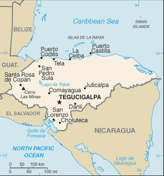
This state is located in Central America, bordering the Caribbean Sea, between Guatemala and Nicaragua and bordering the Gulf of Fonseca (North Pacific Ocean), between El Salvador and Nicaragua, under the coordinates of 15 00 N, 86 30 W, covering an area of 112,090 sq km with a coastline of 823 km. Honduras is Slightly larger than Tennessee.
Honduras has 1,575 km of land boundaries in total and borders with (3 nations): Guatemala 244 km, El Salvador 391 km, Nicaragua 940 km.
Mostly mountains in interior, narrow coastal plains, with Cerro las minas 2,870 m as the highest point of Honduras, while the Caribbean Sea 0 m as the lowest point, causing a mean elevation at 684 m throughout the country. With a total of 112,090 sq km, Honduras has 111,890 sq km of land and 200 sq km water surface area.
Major water bodies in the country: Laguna de Caratasca – 1,110 sq km (saltwater lake).
Has only a short Pacific coast but a long Caribbean shoreline, including the virtually uninhabited eastern Mosquito Coast.
The climate in Honduras is as follows: Subtropical in lowlands, temperate in mountains.
When you visit Honduras, the natural hazards shall be considered: Frequent, but generally mild, earthquakes; extremely susceptible to damaging hurricanes and floods along the Caribbean coast.
The following major health-threatening issues shall be considered when visiting Honduras: degree of risk: high (2020), bacterial diarrhea, hepatitis A, typhoid fever, dengue fever, and malaria.
Current environmental issues affecting the Honduran people: urban population expanding; deforestation results from logging and the clearing of land for agricultural purposes; further land degradation and soil erosion hastened by uncontrolled development and improper land-use practices such as the farming of marginal lands; mining activities are polluting Lago de Yojoa (the country’s largest source of fresh water), as well as several rivers and streams, with heavy metals.
Google Maps Honduras
The capital and other divisions
Capital city: Tegucigalpa found under the coordinates 14 06 N, 87 13 W, applying the time zone UTC-6 (1 hour behind Washington, DC during Standard Time), using the following daylight saving time: none.
The capital of Honduras, Tegucigalpa, is a popular destination for travelers interested in experiencing Central American culture in general and Honduran history in particular.
Honduras became independent on 15 September 1821 (from Spain), and its national holiday is Independence Day, 15 September (1821).
Administrative divisions: 18 departments (departamentos, singular – departamento); Atlantida, Choluteca, Colon, Comayagua, Copan, Cortes, El Paraiso, Francisco Morazan, Gracias a Dios, Intibuca, Islas de la Bahia, La Paz, Lempira, Ocotepeque, Olancho, Santa Barbara, Valle, Yoro.
People and society
The majority of the population is mestizo (mixed EuropeanAmerindian). An English-speaking garífuna (black) community and Miskito Amerindians struggle to preserve their rights to land along the remote Caribbean coast. Womens status remains low. Wealth inequalities are significant, and poverty is at the root of social tension. Two-thirds of the population live in poverty. The army ousted the president in 2009. Violent crime is a significant issue.
The population in Honduras is 9,346,277 (July 2021 estimate). Note: estimates for this country explicitly take into account the effects of excess mortality due to AIDS; this can result in lower life expectancy, higher infant mortality, higher death rates, lower population growth rates, and changes in the distribution of the population by age and sex than would otherwise be expected, with an average of 1.22% (2021 estimate) change. That means Honduras is the No. 95 in the world’s populated rank list. With an average of 24.4 years median age (23.5 years for males and 23.5 years for women), Honduras ranks No. 165 on the globe’s median age rank list.
The people living in this country are the Honduran(s) (noun) or Honduran (adjective) and belong mainly to the following ethnic groups: Mestizo (mixed Amerindian and European) 90%, Amerindian 7%, African descent 2%, White 1%.
They speak Spanish (official language), Amerindian dialects languages and practice the following religions: Roman Catholic 46%, Protestant 41%, atheist 1%, other 2%, none 9% (2014 estimate).
We can conclude the following about the population in Honduras: Most residents live in the mountainous western half of the country. Unlike other central american nations, honduras is the only one with an urban population distributed between two large centers – the capital of Tegucigalpa and the city of san pedro sula. The Rio Ulua valley in the north is the only densely populated lowland area. In Honduras, we are talking about 59% (2021) of the total population is living in cities, and most of them reside in the following municipalities: 1.485 million, Tegucigalpa (capital city), 929,000 San Pedro Sula (2021).
Industry
Garments, coffee, bananas, and shellfish are exported. Remittances account for a fifth of GDP. Debt relief from 2005. Mineral potential. High underemployment and corruption.
Honduras, the second poorest country in Central America, suffers from the extraordinarily unequal distribution of income and high underemployment. While historically dependent on the export of bananas and coffee, Honduras has diversified its export base to include apparel and automobile wire harnessing. Honduras’s economy depends heavily on US trade and remittances. The US-Central America-Dominican Republic Free Trade Agreement came into force in 2006 and has helped foster foreign direct investment, but physical and political insecurity, as well as crime and perceptions of corruption, may deter potential investors; about 15% of foreign direct investment is from US firms.
The economy registered modest economic growth of 3.1%-4.0% from 2010 to 2017, insufficient to improve living standards for the nearly 65% of the population in poverty. In 2017, Honduras faced rising public debt, but its economy has performed better than expected due to low oil prices and improved investor confidence. Honduras signed a three-year standby arrangement with the IMF in December 2014 to ease Honduras’s poor fiscal position.
Honduras is rich in the following natural resources: Timber, gold, silver, copper, lead, zinc, iron ore, antimony, coal, fish, hydropower.
The main industrial sectors are sugar processing, coffee, woven and knit apparel, wood products, cigars.
The country’s export sectors are particularly strong in clothing and apparel, coffee, insulated wiring, bananas, palm oil (2019), partnering with these nations: the United States 53%, El Salvador 8%, Guatemala 5%, Nicaragua 5% (2019). The export trade resulted in $7.16 billion. Note: Data are in current year dollars (2019 estimate). In a global rank of the export, values resulted in Honduras’s position of 115.
Land use in Honduras: 45.3% (2018 estimate) forest, 25.9% (2018 estimate) other.
The arable land area is 9.1% (2018 estimate), and the agricultural land is 28.8% (2018 estimate). Land use for permanent crops 4% (2018 estimate), permanent pasture 15.7% (2018 estimate). The sum of the area of the irrigated land is 900 sq km (2012).
The main agro-industrial products of Honduras are sugarcane, oil palm fruit, milk, bananas, maize, coffee, melons, oranges, poultry, beans.
The country typically needs to import: refined petroleum, clothing and apparel, packaged medicines, broadcasting equipment, insulated wiring (2019), partnering with the following nations: United States 42%, China 10%, Guatemala 8%, El Salvador 8%, Mexico 6% (2019) in a sum value of $11.5 billion. Note: data are in current year dollars (2019 estimate) $11.78 billion. Note: data are in current year dollars (2018 estimate). This sum value on the global ranking list of imports resulted in Honduras 99.
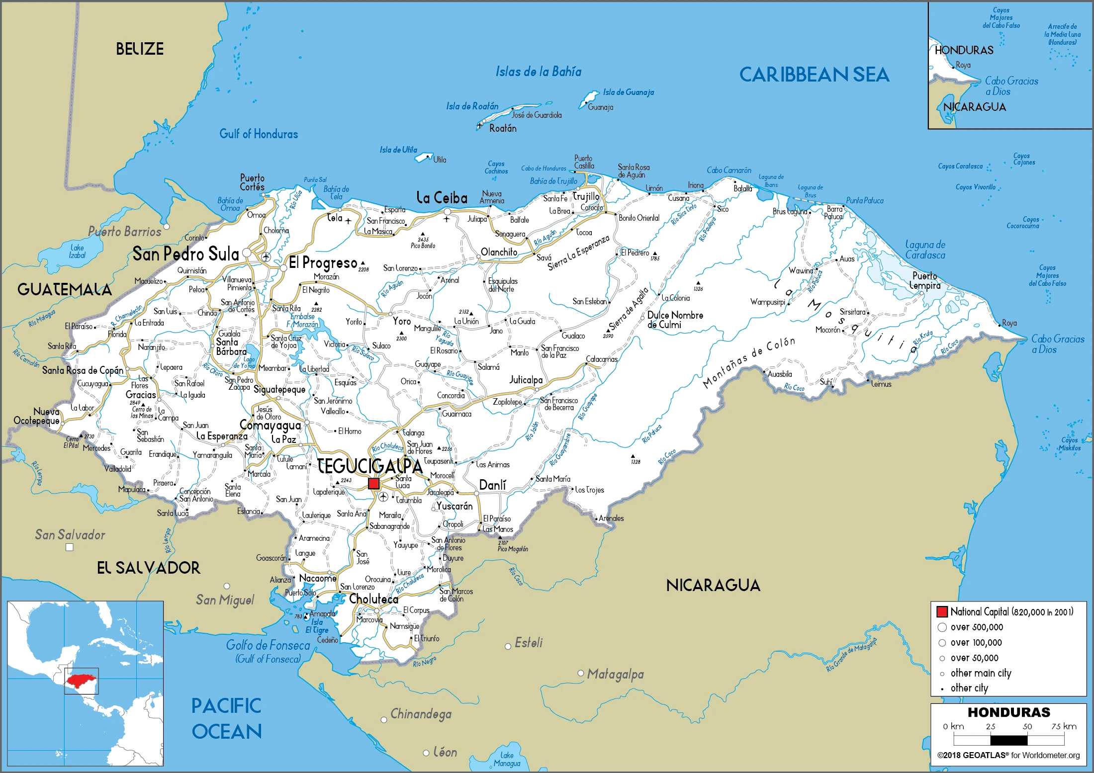
Honduras Driving Directions
In this post, you learned about Honduras, Central America, bordering the Caribbean Sea, Guatemala, and Nicaragua, and bordering the Gulf of Fonseca (North Pacific Ocean) between El Salvador and Nicaragua. We published some basic information about its capital Tegucigalpa, and the Honduran nation.
Are you interested in visiting Honduras and looking for driving directions? Click here to plan your route, or see a printable road map of Honduras below for an overview of the route network.
Printable map of Honduras
Did you know about Honduras?
Honduras is a small country in Central America that people often don’t know much about. One of its most famous attractions is the national park, which is considered one of the most biodiverse places on Earth. Honduras also has beaches and rainforests, which attract many tourists every year.
After virtually visiting Honduras, you may also be interested in the neighboring countries: Guatemala, El Salvador, Nicaragua.
If you liked our Google map and Honduras information page,
please share it with others or save the link https://www.drivingdirections.net in your bookmarks.