
Iceland Google Maps is a site/tool that offers a wide range of map views (topographic, satellite, street view) and navigation options, with little effort on your part, yet efficiently. If you need to plan a trip to a new place like Iceland, Google maps are available on desktop, mobile, or tablet. This Google maps and information page is dedicated to Iceland, Arctic Region (4 countries), showing its location, country facts, details about its capital city Reykjavik, and plenty of other information which may be interesting when you visit this Arctic state.
Quick links: Google Maps Iceland, Reykjavik Google maps, Driving Directions Iceland, Printable Road Map.
About Iceland in a nutshell
- Conventional short form of the name: Iceland
- The conventional long form of the name: Republic of Iceland
- Local long form: Lydveldid Island
- Local short form: Island
- Etymology: Floki VILGERDARSON, an early explorer of the island (9th century), applied the name Land of Ice after spotting a fjord full of drift ice to the north and spending a bitter winter on the island; he eventually settled on the island, however, after he saw how it greened up in the summer and that it was, in fact, habitable.
- The legal system in Iceland: civil law system influenced by the Danish model.
- Climate: Its location in the middle of the Gulf Stream moderates the climate. Mild winters and brief, cool summers.
- The national symbols are gyrfalcon; national colors: blue, white, red.
- Internet TLD: .is
Rising out of the Atlantic Ocean, Iceland lies at the boundary of the Eurasian and North American rock plates. Volcanic activity on the island has been going on for millions of years. It is still active today, evidenced by many after-volcanic activities and heat sources. The word geyser, a common name for volcanic springs worldwide, is named after Iceland’s once most active volcanic source. Located directly below the Arctic Circle, the island’s coastline is moderated by the North Atlantic Current, which means that the sea never freezes. Still, its elevations of over 2,000 m (2,000 m) are home to several permanent ice caps and glaciers, including Europe’s most giant continuous ice sheet, Vatnajökull. The Pingvellir lava field, an extensive plateau on the windswept, barren island, was the site of the first assembly of Iceland – and of our planet – in 930 AD, led by the chiefs of the Al|oing.
Geyser is taken from Geysir (the “gusher”) in southwest Iceland.
Background
Settled by Norwegian and Celtic (Scottish and Irish) immigrants during the late 9th and 10th centuries A.D., Iceland boasts the world’s oldest functioning legislative assembly, the Althingi, established in 930. Independent for over 300 years, Iceland was subsequently ruled by Norway and Denmark. The Askja volcano of 1875 devastated the Icelandic economy and caused widespread famine. Over the next quarter-century, 20% of the island’s population emigrated, mainly to Canada and the U.S. Denmark granted limited home rule in 1874 and complete independence in 1944. The second half of the 20th century saw substantial economic growth driven primarily by the fishing industry. The economy diversified extensively after the country joined the European Economic Area in 1994, but the global financial crisis especially hard hit Iceland following 2008. The economy is upward, fueled primarily by a tourism and construction boom. Literacy, longevity, and social cohesion are first-rate by world standards.
Geography
Grassy coastal lowlands, with fjords in the north. The central plateau of cold lava desert, geothermal springs, and glaciers. Around 200 volcanoes, with numerous geysers and solfataras.
Europes westernmost country, Icelands strategic ocean location, straddles the Mid-Atlantic Ridge. Its spectacular landscape is mainly uninhabited, aside from coastal towns.
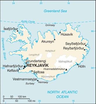
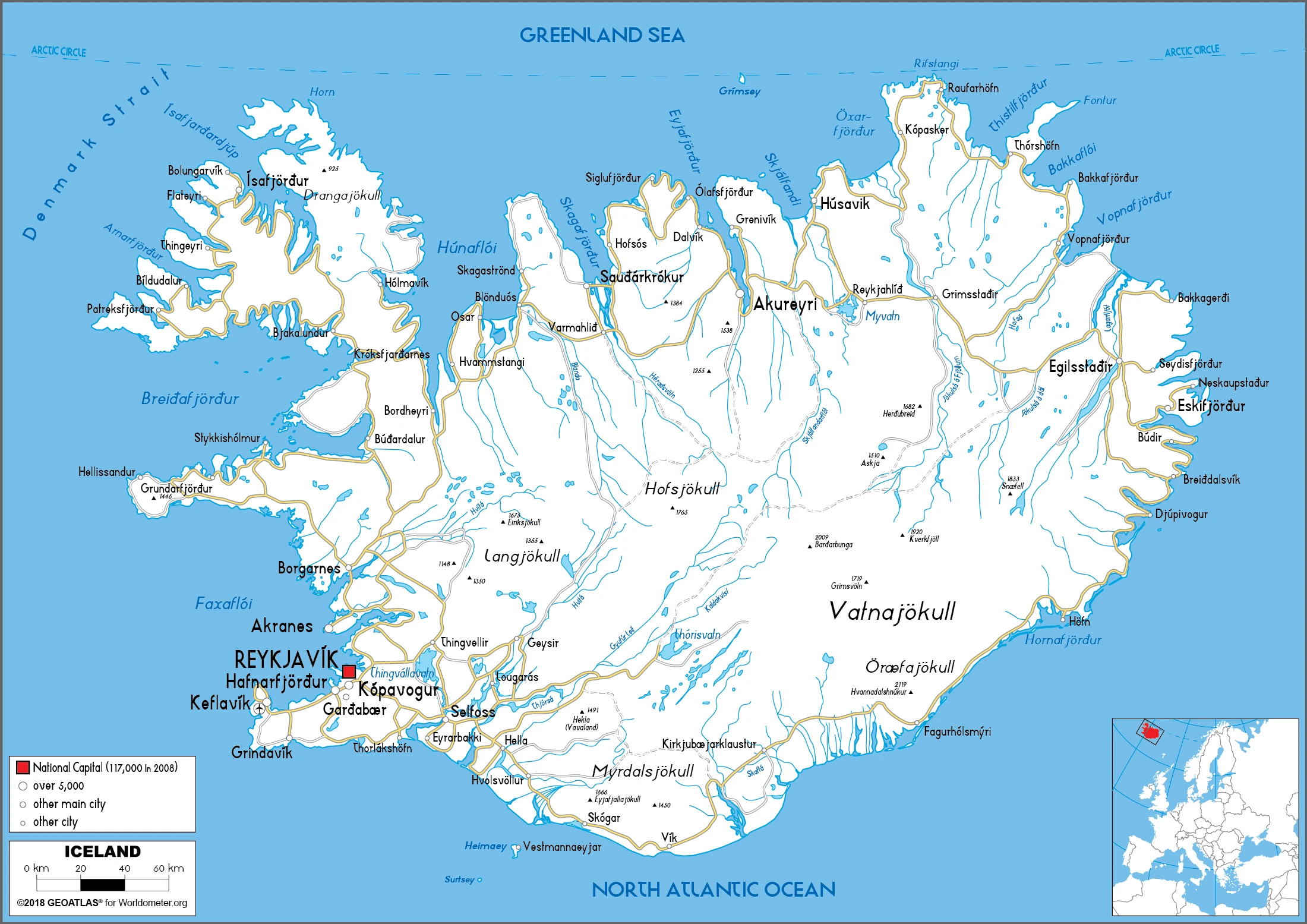
This state is located in Northern Europe, an island between the Greenland Sea and the North Atlantic Ocean, northwest of the United Kingdom, under the coordinates of 65 00 N, 18 00 W, covering an area of 103,000 sq km with a coastline of 4,970 km. Iceland is Slightly smaller than Pennsylvania, about the same size as Kentucky.
Iceland has 0 km of land boundaries in total.
Mostly plateau interspersed with mountain peaks, icefields, coast deeply indented by bays and inlets, with Hvannadalshnukur (at Vatnajokull glacier) 2,110 m as the highest point of Iceland, while Atlantic Ocean 0 m as the lowest point, causing a mean elevation at 557 m throughout the country. With 103,000 sq km, Iceland has 100,250 sq km of land and 2,750 sq km of water surface area.
Strategic location between Greenland and Europe; westernmost European country; Reykjavik is the northernmost national capital in the world; more land covered by glaciers than in all of continental Europe.
The climate in Iceland is as follows: Temperate, moderated by the North Atlantic current, mild, windy winters, damp, cool summers.
When you visit Iceland, the natural hazards shall be considered: Earthquakes and volcanic activity volcanism: Iceland, situated on top of a hotspot, experiences severe volcanic activity; Eyjafjallajokull (1,666 m) erupted in 2010, sending ash high into the atmosphere and seriously disrupting European air traffic; scientists continue to monitor nearby Katla (1,512 m), which has a high probability of an eruption very shortly, potentially disrupting air traffic; Grimsvoetn and Hekla are Iceland’s most active volcanoes; other historically active volcanoes include Askja, Bardarbunga, Brennisteinsfjoll, Esjufjoll, Hengill, Krafla, Krisuvik, Kverkfjoll, Oraefajokull, Reykjanes, Torfajokull, and Vestmannaeyjar.
The following major health-threatening issues shall be considered when visiting Iceland: none.
Current environmental issues affecting the Icelandic people: water pollution from fertilizer runoff.
Google Maps Iceland
The capital and other divisions
Capital city: Reykjavik found under the coordinates 64 09 N, 21 57 W, applying the time zone UTC 0 (5 hours ahead of Washington, DC, during Standard Time), using the following daylight saving time: none.
Reykjavik is a city on the island of Iceland and the most northerly capital in the world. It is known for its many hot springs, geothermal pools, proximity to the ocean, and impressive landscapes. In addition to all that, it has beautiful architecture that you can see in plenty of pictures!
Iceland became independent on 1 December 1918 (became a sovereign state under the Danish Crown); 17 June 1944 (from Denmark; the birthday of Jon SIGURDSSON, leader of Iceland’s 19th Century independence movement), and its national holiday is Independence Day, 17 June (1944).
Administrative divisions: 69 municipalities (sveitarfelog, singular – sveitarfelagidh); Akrahreppur, Akranes, Akureyri, Arneshreppur, Asahreppur, Blaskogabyggdh, Blonduosbaer, Bolungarvik, Borgarbyggdh, Dalabyggdh, Dalvikurbyggdh, Eyjafjardharsveit, Eyja-og Miklaholtshreppur, Fjallabyggdh, Fjardhabyggdh, Fljotsdalshreppur, Floahreppur, Gardhabaer, Grimsnes-og Grafningshreppur, Grindavikurbaer, Grundarfjardharbaer, Grytubakkahreppur, Hafnarfjordhur, Helgafellssveit, Horgarsveit, Hrunamannahreppur, Hunathing Vestra, Hunavatnshreppur, Hvalfjardharsveit, Hveragerdhi, Isafjardharbaer, Kaldrananeshreppur, Kjosarhreppur, Kopavogur, Langanesbyggdh, Mosfellsbaer, Mulathing, Myrdalshreppur, Nordhurthing, Rangarthing Eystra, Rangarthing Ytra, Reykholahreppur, Reykjanesbaer, Reykjavik, Seltjarnarnes, Skaftarhreppur, Skagabyggdh, Skeidha-og Gnupverjahreppur, Skorradalshreppur, Skutustadhahreppur, Snaefellsbaer, Strandabyggdh, Stykkisholmur, Sudhavikurhreppur, Sudhurnesjabaer, Svalbardhshreppur, Svalbardhsstrandarhreppur, Sveitarfelagidh Arborg, Sveitarfelagidh Hornafjordhur, Sveitarfelagidh Olfus, Sveitarfelagidh Skagafjordhur, Sveitarfelagidh Skagastrond, Sveitarfelagidh Vogar, Talknafjardharhreppur, Thingeyjarsveit, Tjorneshreppur, Vestmannaeyjar, Vesturbyggdh, Vopnafjardharhreppur.
People and society
Icelanders share a solid national identity with few foreign residents. Their language has changed little in 700 years due to the countrys isolation. High social mobility, free health care, and low-cost heating (geothermal and hydropower). Icelands recent banking collapse and near financial ruin has swung the long-running debate over E.U. membership in favor of joining.
The population in Iceland is 354,234 (July 2021 estimate), with an average of 0.97% (2021 estimate) change. That means Iceland is the No. 177 in the world’s populated rank list. With an average of 37.1 years median age (36.6 years for males and 36.6 years for women), Iceland ranks No. 74 on the globe’s median age rank list.
The people living in this country are the Icelander(s) (noun) or Icelandic (adjective) and belong mainly to the following ethnic groups: Icelandic 81.7%, Polish 5.6%, Danish 1%, other 11.7% (2020 estimate). Note: data represent population by country of birth.
They speak Icelandic, English, Nordic languages, German languages and practice the following religions: Evangelical Lutheran Church of Iceland (official) 62.3%, Roman Catholic 4%, Reykjavik Free Church 2.7%, Hafnarfjordur Free Church 2%, pagan worship 1.4%, Icelandic Ethical Humanist 1.1%, other religions 4% (includes Zuist and Pentecostal), none 7.6%, other or unspecified 15% (2020 estimate).
We can conclude the following about the population in Iceland: Iceland is almost entirely urban, with half of the population located in and around the capital of Reykjavik. Smaller clusters are primarily found along the coast in the north and west. In Iceland, we are talking about 93.9% (2021) of the total population lives in cities, and most of them reside in the following municipalities: 216,000 Reykjavik (capital city) (2018).
Industry
Once reliant on fish. Aluminum smelting. Tourism. Banks overexposed in the 20072009 global downturn. Nation bankrupt, króna depreciated 90%.
Iceland’s economy combines a capitalist structure and free-market principles with an extensive welfare system. Except for a brief period during the 2008 crisis, Iceland has achieved high growth, low unemployment, and remarkably even income distribution in recent years. Iceland’s economy has been diversifying into manufacturing and service industries in the last decade, particularly in tourism, software production, and biotechnology. Abundant geothermal and hydropower sources have attracted substantial foreign investment in the aluminum sector, boosted economic growth, and sparked some interest from high-tech firms looking to establish data centers using cheap green energy., Tourism, aluminum smelting, and fishing are the pillars of the economy. For decades the Icelandic economy depended heavily on fisheries, but tourism has now surpassed fishing and aluminum as Iceland’s primary export industry. Tourism accounted for 8.6% of Iceland’s GDP in 2016 and 39% of total merchandise and services exports.
From 2010 to 2017, tourists visiting Iceland increased by nearly 400%. Since 2010, tourism has become the main driver of Icelandic economic growth, with the number of tourists reaching 4.5 times the Icelandic population in 2016. Iceland remains sensitive to fluctuations in world prices for its main exports and fluctuations in the exchange rate of the Icelandic Krona. Following the privatization of the banking sector in the early 2000s, domestic banks expanded aggressively in foreign markets, and consumers and businesses borrowed heavily in foreign currencies. Worsening global financial conditions throughout 2008 resulted in a sharp depreciation of the krona vis-a-vis other major currencies. The foreign exposure of Icelandic banks, whose loans and other assets totaled nearly nine times the country’s GDP, became unsustainable. Iceland’s three largest banks collapsed in late 2008. GDP fell 6.8% in 2009, and unemployment peaked at 9.4% in February 2009. Three new banks were established to take over the domestic assets of the collapsed banks. Two of them have majority ownership by the state, which intends to re-privatize them., Since the collapse of Iceland’s financial sector, government economic priorities have included stabilizing the krona, implementing capital controls, reducing Iceland’s high budget deficit, containing inflation, addressing high household debt, restructuring the financial sector, and diversifying the economy. Capital controls were lifted in March 2017, but some financial protections, such as reserve requirements for specified investments connected to new inflows of foreign currency, remain in place.
Iceland is rich in the following natural resources: Fish, hydropower, geothermal power, diatomite.
The main industrial sectors are tourism, fish processing, aluminum smelting, geothermal power, hydropower, medical/pharmaceutical products.
The country’s export sectors are particularly strong in aluminum and aluminum products, fish products, aircraft, iron alloys, animal meals (2019), partnering with these nations: Netherlands 23%, United Kingdom 9%, Germany 9%, Spain 8%, United States 7%, France 7%, Canada 5% (2019). The export trade resulted in $7.43 billion. Note: Data are in current year dollars (2020 estimate). In a global rank of the export, values resulted in Iceland’s position of 113.
Land use in Iceland: 0.3% (2018 estimate) forest, 81% (2018 estimate) other.
The arable land area is 1.2% (2018 estimate), and the agricultural land is 18.7% (2018 estimate). Land use for permanent crops 0% (2018 estimate), permanent pasture 17.5% (2018 estimate).
The main agro-industrial products of Iceland are milk, mutton, poultry, potatoes, barley, pork, eggs, beef, other meat, sheepskins.
The country typically needs to import: refined petroleum, aluminum oxide, carbon/graphite electronics, cars, packaged medicines (2019), partnering with the following nations: Norway 11%, Netherlands 10%, Germany 8%, Denmark 8%, United States 7%, United Kingdom 6%, China 6%, Sweden 5% (2019) in a sum value of $7.55 billion. Note: data are in current year dollars (2020 estimate) $9.76 billion. Note: data are in current year dollars (2019 estimate) $11.34 billion. Note: data are in current year dollars (2018 estimate). This sum value on the global ranking list of imports resulted in Iceland 120.
Iceland Driving Directions
In this post, you learned about Iceland, Northern Europe, the island between the Greenland Sea, and the North Atlantic Ocean, northwest of the United Kingdom. We published some basic information about its capital Reykjavik, and the Icelandic nation.
Are you interested in visiting Iceland and looking for driving directions? Click here to plan your route, or see a printable road map of Iceland below for an overview of the route network.
Printable map of Iceland
Did you know about Iceland?
Iceland is known worldwide for its natural beauty and its friendly people. The Reykjavik area is famous for its geothermal hot springs, volcanic steam vents, and the surrounding low-lying hills covered with grasses. It was only a matter of time before it became a popular tourist destination.
After virtually visiting Iceland, you may also be interested in the neighboring countries: none.
If you liked our Google map and Iceland information page,
please share it with others or save the link https://www.drivingdirections.net in your bookmarks.