
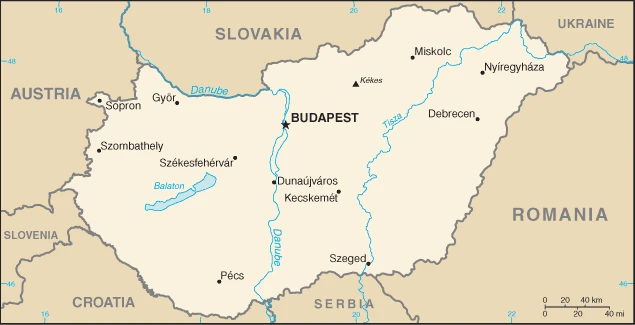
Hungary Google Maps is a site/tool that offers a wide range of map views (topographic, satellite, street view) and navigation options, with little effort on your part, yet efficiently. If you need to plan a trip to a new place like Hungary, Google maps are available on desktop, mobile, or tablet. This Google maps and information page is dedicated to Hungary, Europe (47 countries), showing its location, country facts, details about its capital city Budapest, bordering countries like Austria, Croatia, Romania, Serbia, Slovakia, Slovenia, Ukraine, and plenty of other information which may be interesting when you visit this European state.
Quick links: Google Maps Hungary, Budapest Google maps, Driving Directions Hungary, Printable Road Map.
About Hungary in a nutshell
- Conventional short form of the name: Hungary
- The conventional long form of the name: none
- Local long form: none
- Local short form: Magyarorszag
- Former name(s): the Kingdom of Hungary, Hungarian Peoples Republic, Hungarian Soviet Republic, Hungarian Republic
- Etymology: the Byzantine Greeks referred to the tribes that arrived on the steppes of Eastern Europe in the 9th century as the Oungroi, a name that was later Latinized to Ungri and which became Hungari; the name originally meant an alliance of ten tribes; the Hungarian name Magyarorszag means Country of the Magyars; the term may derive from the most prominent of the Hungarian tribes, the Megyer.
- The legal system in Hungary: civil legal system influenced by the German model.
- Climate: Continental, with wet springs, late but sweltering summers, and cold, cloudy winters. The transition between seasons tends to be sudden.
- The national symbols are the Holy Crown of Hungary (Crown of Saint Stephen), while the national colors: red, white, and green.
- Internet TLD: .hu
Occupying a large part of the Carpathian Basin, the country has a very diverse natural environment, and its World Heritage sites are also among the country’s most outstanding tourist attractions. The more than 700 (!) caves of the Aggtelek and Slovak Karsts, with their diverse formations and stalactites, and the cultural heritage of the Lake Fertő area are common heritage with neighboring countries. The traditional architecture of the villages and the 18th and 19th-century castles in the area add exceptional cultural interest to the landscape. The Hortobágy salt marshes were grazed and trampled by Hungarian shepherds for centuries – the Hortobágy National Park preserves this rare cultural landscape shaped by human activity.
The vineyards and cellars of the historic Tokaj wine region, not to mention its unforgettable flavors, offer visitors a different kind of cultural landscape. The old village of Hollókő, hidden among the slopes of the Cserhát, and its surroundings, with its traditional folk architecture, are another artificial heritage site. Pécs, the former Sopianae, with its Roman early Christian burial chambers richly decorated with wall paintings, the thousand-year-old Benedictine Abbey of Pannonhalma, home to Hungary’s first school, and last but not least, Budapest, considered one of the most beautiful cities in the world, with its Aquincum, the Buda Castle District, the Danube embankment and Andrássy Avenue, evoking the capital’s significant historical periods, complete the list of Hungary’s World Heritage sites.
The Hungarian language is Asian in origin and closely related to Finnish.
Background
Hungary became a Christian kingdom in A.D. 1000 and served as a bulwark against Ottoman Turkish expansion in Europe for many centuries. The kingdom eventually became part of the polyglot Austro-Hungarian Empire, which collapsed during World War I. The country fell under communist rule following World War II. In 1956, Moscow met a revolt and announced withdrawal from the Warsaw Pact with massive military intervention. Under the leadership of Janos KADAR in 1968, Hungary began liberalizing its economy, introducing so-called Goulash Communism. Hungary held its first multiparty elections in 1990 and initiated a free market economy. It joined NATO in 1999 and the E.U. five years later.
Geography
Landlocked. Fertile plains in the east and northwest; the West and north are hilly. The Danube River cuts through the country and the capital.
Landlocked in central Europe, Hungary was one of the twin centers of the once-great Habsburg Empire. It lost two-thirds of its historical territory for supporting Germany in WW I.
This state is located in Central Europe, northwest of Romania, under the coordinates of 47 00 N, 20 00 E, covering an area of 93,028 sq km with a coastline of 0 km (landlocked country). Hungary is Slightly smaller than Virginia, about the same size as Indiana.
Hungary has 2,106 km of land boundaries and borders (7 nations): Austria 321 km, Croatia 348 km, Romania 424 km, Serbia 164 km, Slovakia 627 km, Slovenia 94 km, Ukraine 128 km.
Mostly flat to rolling plains, hills, and low mountains on the Slovakian border, with Kekes 1,014 m as the highest point of Hungary, while Tisza River 78 m as the lowest point, causing a mean elevation at 143 m throughout the country. With 93,028 sq km, Hungary has 89,608 sq km of land and 3,420 sq km of water surface area.
Major water bodies in the country: Lake Balaton – 590 sq km (a freshwater lake), while the significant river is: the Danube (shared with Germany, Austria, Slovakia, Croatia, Serbia, Bulgaria, Ukraine, Moldova, and Romania) – 2,888 km note. The significant watersheds for Hungary are the Atlantic Ocean drainage: (Black Sea) and Danube (795,656 sq km).
Landlocked; strategic location astride main land routes between Western Europe and Balkan Peninsula and between Ukraine and Mediterranean basin; the north-south flowing Duna (Danube) and Tisza Rivers divide the country into three large regions.
The climate in Hungary is as follows: Temperate, cold, cloudy, humid winters, and warm summers.
When you visit Hungary, the natural hazards shall be considered: none.
The following major health-threatening issues shall be considered when visiting Hungary: degree of risk: intermediate (2016), tick-borne encephalitis (2016).
Current environmental issues affecting the Hungarian people: air and water pollution are some of Hungary’s most serious environmental problems; water quality in the Hungarian part of the Danube has improved but is still plagued by pollutants from industry and large-scale agriculture; soil pollution.
Google Maps Hungary
The capital and other divisions
Capital city: Budapest found under the coordinates 47 30 N, 19 05 E, applying the time zone UTC+1 (6 hours ahead of Washington, DC, during Standard Time), using the following daylight saving time: +1hr begins last Sunday in March; ends last Sunday in October.
Budapest is the capital of Hungary. The city has been continuously inhabited since the Bronze age, and it’s currently home to 1.9 million people. It’s one of the largest cities in central Europe with a serene atmosphere and an exciting history that dates back a thousand-year!
Hungary became independent on 16 November 1918 (republic proclaimed); notable earlier dates: 25 December 1000 (crowning of King STEPHEN I, traditional founding date); 30 March 1867 (Austro-Hungarian dual monarchy established), and its national holiday is Saint Stephens Day, 20 August (1083).
Administrative divisions: 19 counties (megyek, singular – megye), 23 cities with county rights (megyei jogu varosok, singular – megyei jogu varos), and 1 capital city (fovaros) counties: Bacs-Kiskun, Baranya, Bekes, Borsod-Abauj-Zemplen, Csongrad-Csanad, Fejer, Gyor-Moson-Sopron, Hajdu-Bihar, Heves, Jasz-Nagykun-Szolnok, Komarom-Esztergom, Nograd, Pest, Somogy, Szabolcs-Szatmar-Bereg, Tolna, Vas, Veszprem, Zala cities with county rights: Bekescsaba, Debrecen, Dunaujvaros, Eger, Erd, Gyor, Hodmezovasarhely, Kaposvar, Kecskemet, Miskolc, Nagykanizsa, Nyiregyhaza, Pecs, Salgotarjan, Sopron, Szeged, Szekesfehervar, Szekszard, Szolnok, Szombathely, Tatabanya, Veszprem, Zalaegerszeg capital city: Budapest.
People and society
Hungarys population has been shrinking since the 1980s. Mostly ethnic Hungarian (Magyar), tiny minorities of Germans, Jews, and neighboring peoples. Roma faces particular discrimination. The government is greatly concerned about the fate of ethnic Hungarians in Romania, Serbia, and Slovakia. Hungary joined the E.U. in 2004. Working hours are longer than in western Europe.
The population in Hungary is 9,728,337 (July 2021 estimate), with an average of -0.29% (2021 estimate) change. That means Hungary is the No. 93 in the world’s populated rank list. With an average of 43.6 years median age (41.5 years for males and 41.5 years for women), Hungary ranks No. 24 on the globe’s median age rank list.
The people living in this country are the Hungarian(s) (noun) or Hungarian (adjective) and belong mainly to the following ethnic groups: Hungarian 85.6%, Romani 3.2%, German 1.9%, other 2.6%, unspecified 14.1% (2011 estimate). Note: percentages add up to more than 100% because respondents were able to identify more than one ethnic group; Romani populations are usually underestimated in official statistics and may represent 510% of Hungary’s population.
They speak Hungarian (official language) 99.6%, English 16%, German 11.2%, Russian 1.6%, Romanian 1.3%, French 1.2%, other 4.2% languages and practice the following religions: Roman Catholic 37.2%, Calvinist 11.6%, Lutheran 2.2%, Greek Catholic 1.8%, other 1.9%, none 18.2%, no response 27.2% (2011 estimate).
We can conclude the following about the population in Hungary: A fairly even distribution throughout most of the country, with urban areas attracting larger and denser populations. In Hungary, we are talking about 72.2% (2021) of the total population living in cities, and most of them reside in the following municipalities: 1.772 million, Budapest (capital city) (2021).
Industry
Strong industrial base. Hard-hit by 2007-2009 global downturn: currency plummeted. IMF bailout to avoid a meltdown. Spending cuts. Fast growth in 2014. No date set for joining euro.
Hungary has transitioned from a centrally planned to a market-driven economy with a per capita income of approximately two-thirds of the EU-28 average; however, the government has become more involved in managing the economy in recent years. Budapest has implemented unorthodox economic policies to boost household consumption and has relied on EU-funded development projects to generate growth. Following the fall of communism in 1990, Hungary experienced a drop-off in exports and financial assistance from the former Soviet Union. Hungary embarked on a series of economic reforms, including privatization of state-owned enterprises and reduction of social spending programs, to shift from a centrally planned to a market-driven economy and reorient its economy towards trade with the West. These efforts helped spur growth, attract investment, and reduce Hungary’s debt burden and fiscal deficits. Despite these reforms, living conditions for the average Hungarian initially deteriorated as inflation increased and unemployment reached double digits. Conditions slowly improved over the 1990s as the reforms came to fruition and export growth accelerated. Economic policies instituted during that decade helped position Hungary to join the European Union in 2004. Hungary has not yet joined the eurozone.
Hungary suffered a historic economic contraction due to the global economic slowdown in 2008-09 as export demand and domestic consumption dropped, prompting it to take an IMF-EU financial assistance package. Since 2010, the government has backpedaled on many economic reforms and taken a more populist approach toward economic management. Through legislation, regulation, and public procurements, the government has favored national industries and government-linked businesses. In 2011 and 2014, Hungary nationalized private pension funds, which squeezed financial service providers out of the system and helped Hungary curb its public debt and lower its budget deficit to below 3% of GDP, as subsequent pension contributions were channeled into the state-managed pension fund. Hungary’s public debt (at 74.5% of GDP) is still high compared to E.U. peers in Central Europe.
Real GDP growth has been robust in the past few years due to increased E.U. funding, higher E.U. demand for Hungarian exports, and a rebound in domestic household consumption. To further boost household consumption ahead of the 2018 election, the government embarked on a six-year phased increase to minimum wages and public sector salaries, decreased taxes on foodstuffs and services, cut the personal income tax from 16% to 15%, and implemented a uniform 9% business tax for small and medium-sized enterprises and large companies. Real GDP growth slowed in 2016 due to a cyclical decrease in E.U. funding but increased to 3.8% in 2017 as the government pre-financed EU-funded projects ahead of the 2018 election. Systemic economic challenges include pervasive corruption, labor shortages driven by demographic declines and migration, widespread poverty in rural areas, vulnerabilities to changes in demand for exports, and a heavy reliance on Russian energy imports.
Hungary is rich in the following natural resources: Bauxite, coal, natural gas, fertile soils, and arable land.
The main industrial sectors are mining, metallurgy, construction materials, processed foods, textiles, chemicals (especially pharmaceuticals), and motor vehicles.
The country’s export sectors are powerful in cars and vehicle parts, packaged medicines, spark-ignition engines, video displays, and broadcasting equipment (2019), partnering with these nations: Germany 27%, Romania 5%, Italy 5%, Slovakia 5% (2019). The export trade resulted in $123.83 billion. Note: Data are in current year dollars (2020 estimate). In a global rank of the export, values resulted in Hungary’s position of 36.
Land use in Hungary: 22.5% (2018 estimate) forest, 18.6% (2018 estimate) other.
The arable land area is 48.5% (2018 estimate), and the agricultural land is 58.9% (2018 estimate). Land use for permanent crops 2% (2018 estimate), permanent pasture 8.4% (2018 estimate). The sum of the area of the irrigated land is 1,721 sq km (2012).
The main agro-industrial products of Hungary are maize, wheat, milk, sunflower seed, barley, rapeseed, sugar beet, apples, pork, and grapes.
The country typically needs to import: cars and vehicle parts, integrated circuits, packaged medicines, broadcasting equipment, and crude petroleum (2019), partnering with the following nations: Germany 25%, China 6%, Poland 6%, Austria 6%, Czechia 5%, Slovakia 5%, Italy 5%, Netherlands 5% (2019) in a sum value of $120.25 billion. Note: data are in current year dollars (2020 estimate) $129.9 billion. Note: data are in current year dollars (2019 estimate) $127.52 billion. Note: data are in current year dollars (2018 estimate). This sum value on the global ranking list of imports resulted in Hungary 35.
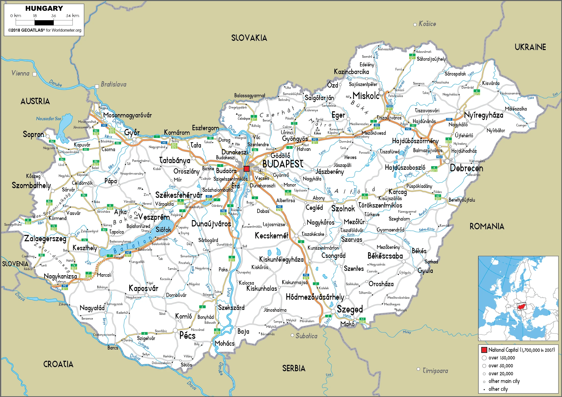
Hungary Driving Directions
In this post, you learned about Hungary, Central Europe, and northwest Romania. We published basic information about its capital Budapest, and the Hungarian nation.
Are you interested in visiting Hungary and looking for driving directions? Click here to plan your route, or see a printable road map of Hungary below for an overview of the route network.
Printable map of Hungary
Did you know about Hungary?
Hungary is in Central Europe, where the influences of both Western and Eastern Europe are visible. The country’s south-eastern border is the Serbian frontier. Hungary has a long history of agriculture, and its main crop is grain. It has rich deposits of other minerals like copper, lead, silver, and zinc that are mined in about a dozen towns and villages. Hungarians had developed a rich tradition of making their goods during a time when hunger was not unheard of from country to country. Today, the production of textiles still ranks high among the export portfolio in Hungary and processed food products.
After virtually visiting Hungary, you may also be interested in the neighboring countries: Austria, Croatia, Romania, Serbia, Slovakia, Slovenia, and Ukraine.
If you liked our Google map and Hungary information page,
please share it with others or save the link https://www.drivingdirections.net in your bookmarks.