
Slovenia Google Maps is a site/tool that offers a wide range of map views (topographic, satellite, street view) and navigation options, with little effort on your part, yet efficiently. If you need to plan a trip to a new place like Slovenia, Google maps are available on desktop, mobile, or tablet. This Google maps and information page is dedicated to Slovenia, Europe (47 countries), showing its location, country facts, details about its capital city Ljubljana, bordering countries like Austria, Croatia, Hungary, Italy, and plenty of other information which may be interesting when you visit this European state.
Quick links: Google Maps Slovenia, Ljubljana Google maps, Driving Directions Slovenia, Printable Road Map.
About Slovenia in a nutshell
- Conventional short form of the name: Slovenia
- The conventional long form of the name: Republic of Slovenia
- Local long form: Republika Slovenija
- Local short form: Slovenija
- Former name(s): Peoples Republic of Slovenia, Socialist Republic of Slovenia
- Etymology: the country’s name means Land of the Slavs in Slovene.
- The legal system in Slovenia: civil law system.
- Climate: Mediterranean on the small coastal strip. The alpine interior has continental extremes.
- The national symbols are Mount Triglav; national colors: white, blue, red.
- Internet TLD: .si
Slovenia is dominated by the Julian Alps and the Karavanke ranges, which rise above 2,500 m, and the foothills of the Slovenian High Karst. The first Slavic-speaking Slovenians settled in the region in the 6th century, and two centuries later, it was ruled by the Germanic tribes and then by the Holy Roman Empire. The Austro-German Empire ruled almost uninterruptedly from the 14th century until 1918. It was part of Yugoslavia for 45 years after the Second World War. It became the first of the member republics to withdraw from the Yugoslav Federation in 1991 before joining the European Union in 2004. Ljubljana is one of the oldest Roman settlements in Europe. The Slovenian-Ma-Gas Karst is the name of the karst phenomena. Of the 20 or so caves in the Postojna Basin, the most visited is the Postojna stalactite cave, which is served by a small railway. Europe’s largest cave halls and stalactite formations are hidden in the World Heritage-listed Skocjani Cave.
A wheel found in a marsh in 2003 is claimed to be the worlds oldest, pre-dating 3000 BCE.
Background
The Slovene lands were part of the Austro-Hungarian Empire until the latter’s dissolution during World War I. In 1918, the Slovenes joined the Serbs and Croats to form a new multinational state, Yugoslavia, in 1929. After World War II, Slovenia was one of the republics in restored Yugoslavia, which, though communist, soon distanced itself from the Soviet Union and spearheaded the Non-Aligned Movement. Dissatisfied with the exercise of power by the majority of Serbs, the Slovenes succeeded in establishing their independence in 1991 after a short 10-day war. Historical ties to Western Europe, a growing economy, and a stable democracy have assisted Slovenia’s post-communist transition. Slovenia acceded to both NATO and the EU in the spring of 2004. It joined the eurozone and the Schengen zone in 2007.
Geography
Alpine terrain with hills and mountains. Forests cover almost half the countrys area. There is a short coastline on the Adriatic Sea.
Lying at the junction of central Europe and the Balkans, Slovenia seceded from socialist Yugoslavia in 1991. In 2004, it became the first former Yugoslav state to join the EU.
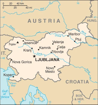
This state is located in South Central Europe, the Julian Alps between Austria and Croatia, under the coordinates of 46 07 N, 14 49 E, covering an area of 20,273 sq km with a coastline of 46.6 km. Slovenia is slightly smaller than New Jersey.
Slovenia has 1,211 km of land boundaries in total and borders (4 nations): Austria 299 km, Croatia 600 km, Hungary 94 km, and Italy 218 km.
A short southwestern coastal strip of karst topography on the Adriatic, an alpine mountain region lies adjacent to Italy and Austria in the north, mixed mountains, and valleys with numerous rivers to the east, with Triglav 2,864 m as the highest point of Slovenia, while the Adriatic Sea 0 m as the lowest point, causing a mean elevation at 492 m throughout the country. With a total of 20,273 sq km, Slovenia has 20,151 sq km of land and 122 sq km of water surface area.
The significant watersheds for Slovenia are the Atlantic Ocean drainage: (Black Sea) Danube (795,656 sq km).
This eastern Alpine country controls some of Europe’s major transit routes despite its small size.
The climate in Slovenia is as follows: Mediterranean climate on the coast, continental climate with mild to hot summers and cold winters in the plateaus, and valleys to the east.
When you visit Slovenia, the natural hazards shall be considered: Flooding; earthquakes.
The following major health-threatening issues shall be considered when visiting Slovenia: none.
Current environmental issues affecting the Slovenian people: air pollution from road traffic, domestic heating (wood burning), power generation, and industry; water pollution; biodiversity protection.
Google Maps Slovenia
The capital and other divisions
Capital city: Ljubljana found under the coordinates 46 03 N, 14 31 E, applying the time zone UTC+1 (6 hours ahead of Washington, DC, during Standard Time), using the following daylight saving time: +1hr begins last Sunday in March; ends last Sunday in October.
Ljubljana is the capital of Slovenia. It’s one of the most beautiful cities in Europe, with a rich history and culture. The city is known for its castles and museums and has become a great destination for exploring all over Europe. It is known for its baroque Old Town, which was voted one of the New Seven Wonders of the World when inscribed as such in 2007. The buildings are all so different and beautiful; it’s one of the must-see places in Europe.
Slovenia became independent on 25 June 1991 (from Yugoslavia), and its national holiday is Independence Day/Statehood Day, 25 June (1991).
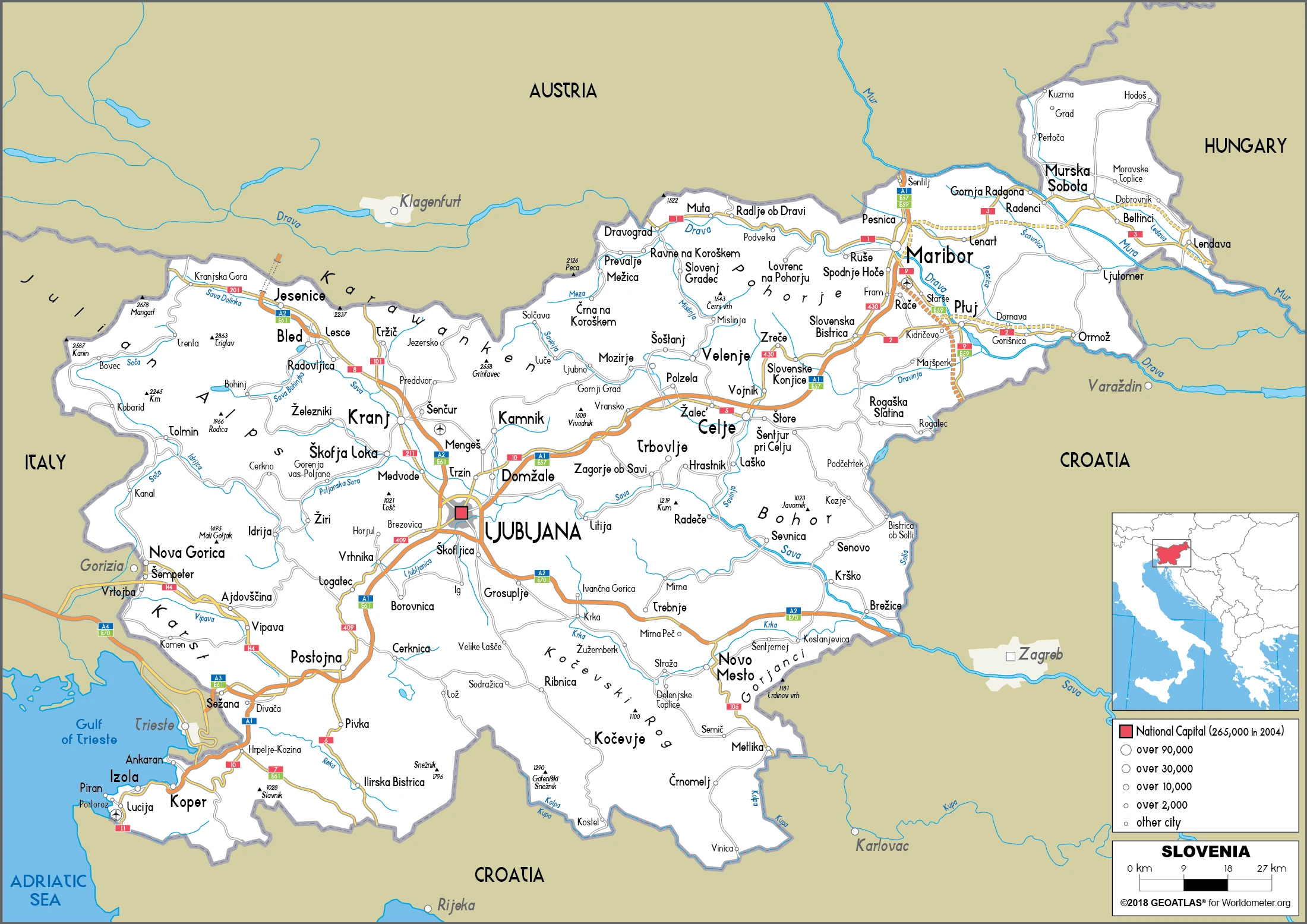
Administrative divisions: 201 municipalities (obcine, singular – obcina) and 11 urban municipalities (mestne obcine, singular – mestna obcina) municipalities: Ajdovscina, Ankaran, Apace, Beltinci, Benedikt, Bistrica ob Sotli, Bled, Bloke, Bohinj, Borovnica, Bovec, Braslovce, Brda, Brezice, Brezovica, Cankova, Cerklje na Gorenjskem, Cerknica, Cerkno, Cerkvenjak, Cirkulane, Crensovci, Crna na Koroskem, Crnomelj, Destrnik, Divaca, Dobje, Dobrepolje, Dobrna, Dobrova-Polhov Gradec, Dobrovnik/Dobronak, Dolenjske Toplice, Dol pri Ljubljani, Domzale, Dornava, Dravograd, Duplek, Gorenja Vas-Poljane, Gorisnica, Gorje, Gornja Radgona, Gornji Grad, Gornji Petrovci, Grad, Grosuplje, Hajdina, Hoce-Slivnica, Hodos, Horjul, Hrastnik, Hrpelje-Kozina, Idrija, Ig, Ilirska Bistrica, Ivancna Gorica, Izola/Isola, Jesenice, Jezersko, Jursinci, Kamnik, Kanal ob Soci, Kidricevo, Kobarid, Kobilje, Kocevje, Komen, Komenda, Kosanjevica na Krki, Kostel, Kozje, Kranjska Gora, Krizevci, Krsko, Kungota, Kuzma, Lasko, Lenart, Lendava/Lendva, Litija, Ljubno, Ljutomer, Log-Dragomer, Logatec, Loska Dolina, Loski Potok, Lovrenc na Pohorju, Luce, Lukovica, Majsperk, Makole, Markovci, Medvode, Menges, Metlika, Mezica, Miklavz na Dravskem Polju, Miren-Kostanjevica, Mirna, Mirna Pec, Mislinja, Mokronog-Trebelno, Moravce, Moravske Toplice, Mozirje, Muta, Naklo, Nazarje, Odranci, Oplotnica, Ormoz, Osilnica, Pesnica, Piran/Pirano, Pivka, Podcetrtek, Podlehnik, Podvelka, Poljcane, Polzela, Postojna, Prebold, Preddvor, Prevalje, Puconci, Race-Fram, Radece, Radenci, Radlje ob Dravi, Radovljica, Ravne na Koroskem, Razkrizje, Recica ob Savinji, Rence-Vogrsko, Ribnica, Ribnica na Pohorju, Rogaska Slatina, Rogasovci, Rogatec, Ruse, Salovci, Selnica ob Dravi, Semic, Sempeter-Vrtojba, Sencur, Sentilj, Sentjernej, Sentjur, Sentrupert, Sevnica, Sezana, Skocjan, Skofja Loka, Skofljica, Slovenska Bistrica, Slovenske Konjice, Smarje pri Jelsah, Smarjeske Toplice, Smartno ob Paki, Smartno pri Litiji, Sodrazica, Solcava, Sostanj, Sredisce ob Dravi, Starse, Store, Straza, Sveta Ana, Sveta Trojica v Slovenskih Goricah, Sveti Andraz v Slovenskih Goricah, Sveti Jurij ob Scavnici, Sveti Jurij v Slovenskih Goricah, Sveti Tomaz, Tabor, Tisina, Tolmin, Trbovlje, Trebnje, Trnovska Vas, Trzic, Trzin, Turnisce, Velika Polana, Velike Lasce, Verzej, Videm, Vipava, Vitanje, Vodice, Vojnik, Vransko, Vrhnika, Vuzenica, Zagorje ob Savi, Zalec, Zavrc, Zelezniki, Zetale, Ziri, Zirovnica, Zrece, Zuzemberk urban municipalities: Celje, Koper, Kranj, Ljubljana, Maribor, Murska Sobota, Nova Gorica, Novo Mesto, Ptuj, Slovenj Gradec, Velenje.
People and society
Long historical association with western Europe accounts for the “Alpine” rather than “Balkan” outlook of Slovenias people, despite close similarities to other former Yugoslavs. The absence of sizable Serb or Croat minorities made for relatively peaceful secession from Yugoslavia. There are small communities of Italians and Magyars (Hungarians) in the southwest and east.
The population in Slovenia is 2,102,106 (July 2021 estimate), with an average of -0.03% (2021 estimate) change. That means Slovenia is the No. 149 in the world’s populated rank list. With an average of 44.9 years median age (43.4 years for males and 43.4 years for women), Slovenia ranks No. 11 on the globe’s median age rank list.
The people living in this country are the Slovene(s) (noun) or Slovenian (adjective) and belong mainly to the following ethnic groups: Slovene 83.1%, Serb 2%, Croat 1.8%, Bosniak 1.1%, other or unspecified 12% (2002 estimate).
They speak Slovene (official language) 91.1%, Serbo-Croatian 4.5%, other or unspecified 4.4%, Italian (official language, only in municipalities where Italian national communities reside), Hungarian (official language, only in municipalities where Hungarian national communities reside) (2002 estimate) languages and practice the following religions: Catholic 57.8%, Muslim 2.4%, Orthodox 2.3%, other Christian 0.9%, unaffiliated 3.5%, other or unspecified 23%, none 10.1% (2002 estimate).
We can conclude the following about the population in Slovenia: A fairly even distribution throughout most of the country, with urban areas attracting larger and denser populations. Pockets in the mountainous northwest exhibit less density than elsewhere. In Slovenia, we are talking about 55.4% (2021) of the total population living in cities, and most of them reside in the following municipalities: 286,000 Ljubljana (capital city) (2018).
Industry
First new EU member to join eurozone (in 2007). Export-oriented, so vulnerable to global economic trends. Competitive manufacturing industry. The sizable state-owned sector remains.
With excellent infrastructure, a well-educated workforce, and a strategic location between the Balkans and Western Europe, Slovenia has one of the highest per capita GDPs in Central Europe, despite having suffered a protracted recession in the 2008-2009 period in the wake of the global financial crisis. Slovenia became the first 2004 EU entrant to adopt the euro (on 1 January 2007) and has experienced a stable political and economic transition. In March 2004, Slovenia became the first transition country to graduate from borrower status to donor partner at the World Bank. In 2007, Slovenia was invited to begin joining the OECD; it became a member in 2012. From 2014 to 2016, export-led growth, fueled by demand in larger European markets, pushed annual GDP growth above 2.3%. Growth reached 5.0% in 2017 and is projected to reach 5% in 2018. What used to be stubbornly high unemployment fell below 5.5% in early 2018, driven by strong exports and increasing consumption that boosted labor demand. Continued fiscal consolidation through increased tax collection and social security contributions will likely result in a balanced government budget in 2019. Prime Minister CERARs government took office in September 2014, pledging to press ahead with commitments to privatize a select group of state-run companies, rationalize public spending, and further stabilize the banking sector. Efforts to privatize Slovenia’s largely state-owned banking sector have stalled, however, amid concerns about an ongoing dispute over Yugoslav-era foreign currency deposits.
Slovenia is rich in the following natural resources: Lignite, lead, zinc, building stone, hydropower, and forests.
The main industrial sectors are typically ferrous metallurgy and aluminum products, lead and zinc smelting, electronics (including military electronics), trucks, automobiles, electric power equipment, wood products, textiles, chemicals, and machine tools.
The country’s export sectors are particularly strong in packaged medicines, cars and vehicle parts, refined petroleum, electrical lighting/signaling equipment, electricity (2019), partnering with these nations: Germany at 18%, Italy at 11%, Croatia at 8% at, Austria at 7%, France at 5%, Switzerland at 5% (2019). The export trade resulted in $41.73 billion. Note: Data are in current year dollars (2020 estimate). In a global rank of the export, values resulted in Slovenia’s position of 60.
Land use in Slovenia: 62.3% (2018 estimate) forest, 14.9% (2018 estimate) other.
The arable land area is 8.4% (2018 estimate), and the agricultural land is 22.8% (2018 estimate). Land use for permanent crops 1.3% (2018 estimate), permanent pasture 13.1% (2018 estimate). The sum of the area of the irrigated land is 60 sq km (2012).
The main agro-industrial products of Slovenia are milk, maize, wheat, grapes, barley, potatoes, poultry, apples, beef, and pork.
The country typically needs to import: packaged medicines, cars and vehicle parts, refined petroleum, delivery trucks, electricity (2019), partnering with the following nations: Germany 14%, Italy 12%, Austria 8%, Switzerland 8%, China 7% (2019) in a sum value of $36.6 billion. Note: data are in current year dollars (2020 estimate) $40.8 billion. Note: data are in current year dollars (2019 estimate) $41.32 billion. Note: data are in current year dollars (2018 estimate). This sum value on the global ranking list of imports resulted in Slovenia 66.
Slovenia Driving Directions
You learned about Slovenia, south Central Europe, and the Julian Alps between Austria and Croatia in this post. We published some basic information about its capital Ljubljana, and the Slovenian nation.
Are you interested in visiting Slovenia and looking for driving directions? Click here to plan your route, or see a printable road map of Slovenia below for an overview of the route network.
Printable map of Slovenia
Did you know about Slovenia?
Slovenia’s population is only 2,1 million people. Its capital is Ljubljana. This city has the lowest unemployment rate of all European Union countries. Slovenia has a rich history, with many Roman ruins and castles left in the area. The country also has an unusual language – it is one of the few languages that use the Latin alphabet but have its own special characters.
After virtually visiting Slovenia, you may also be interested in the neighboring countries: Austria, Croatia, Hungary, and Italy.
If you liked our Google map and Slovenia information page,
please share it with others or save the link https://www.drivingdirections.net in your bookmarks.