
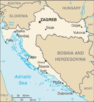
Croatia Google Maps is a site/tool that offers a wide range of map views (topographic, satellite, street view) and navigation options, with little effort on your part, yet efficiently. If you need to plan a trip to a new place like Croatia, Google maps are available on desktop, mobile, or tablet. This Google maps and information page is dedicated to Croatia, Europe (47 countries), showing its location, country facts, details about its capital city Zagreb, bordering countries like Bosnia and Herzegovina, Hungary, Montenegro, Serbia, Slovenia, and plenty of other information which may be interesting when you visit this European state.
Quick links: Google Maps Croatia, Zagreb Google maps, Driving Directions Croatia, Printable Road Map.
About Croatia in a nutshell
- Croatia only regained control of Serb-occupied Eastern Slavonia, around Vukovar, in 1998.
- Conventional short form of the name: Croatia
- The conventional long form of the name: Republic of Croatia
- Local long form: Republika Hrvatska
- Local short form: Hrvatska
- Former name(s): Peoples Republic of Croatia, Socialist Republic of Croatia
- Etymology: name derives from the Croats, a Slavic tribe who migrated to the Balkans in the 7th century A.D..
- The legal system in Croatia: civil law system influenced by legal heritage of Austria-Hungary.
- Climate: The interior has a temperate continental climate. Mediterranean along the Adriatic coast.
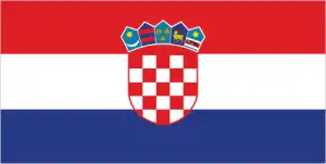
- The national symbols are red-white checkerboard; national colors: red, white, blue.
- Internet TLD: .hr
The country’s northern half is made up of the lowlands of the Drava and Sava rivers and the forested ruggedness between the rivers. At the same time, the Adriatic coast and archipelago are built up by the karstic ranges of the Dinaric Mountains. The first inhabitants of Croatian land, the Illyrians, were followed by the Romans and then, in the 7th century, by the first Slavic Croatian tribes. After the fall of the Tatars, various parts of Croatia were occupied by the Habsburgs, the Hungarian kings, the Venetian Republic, Napoleon, and the pro-Nazi Ustasha, before becoming part of the Yugoslav Federation.
After the bloody war that followed the secession, independent Croatia reopened its doors to tourists in 1995. Today, a significant part of its national income comes from tourism. World Heritage sites are located along the Adriatic coast from Istria to southern Dalmatia, with one exception. Among the country’s many national parks, rich in scenic beauty, the stunningly beautiful Plitvice Lakes National Park, with its collection of waterfalls, lakes, and caves, has been inscribed on the World Natural Heritage List. The historic old town of Trogir was founded by Greek settlers in the 3rd century BC. In the old town of Split, Diocletian’s Palace is the best-preserved piece of Roman architecture in Dalmatia. Dubrovnik, destroyed by earthquakes and war, has always been rebuilt, and its old town is a symbol of the strength of the city-state that ruled the seas from the 13th century onwards. The first Christian monument is the Byzantine basilica of Porec, built around 550 AD, and the 15th-century St James’ Cathedral in Sibenik is the most important Renaissance building in Dalmatia.
Background
Today, the lands that comprise Croatia were part of the Austro-Hungarian Empire until World War I. In 1918, the Croats, Serbs, and Slovenes formed a kingdom known after 1929 as Yugoslavia. Following World War II, Yugoslavia became a federal independent communist state consisting of six socialist republics under the strong hand of Marshal Josip Broz, aka TITO. Although Croatia declared its independence from Yugoslavia in 1991, it took four years of sporadic, but often bitter, fighting before occupying Yugoslav forces, dominated by Serb officers, were mostly cleared from Croatian lands, along with a majority of Croatia’s ethnic Serb population. Under UN supervision, the last Serb-held enclave in eastern Slavonia was returned to Croatia in 1998. The country joined NATO in April 2009 and the EU in July 2013.
Geography
Rocky, the mountainous Adriatic coastline, is dotted with islands. The Interior is a mixture of wooded mountains and broad valleys.
Though it was controlled by Hungary from medieval times and was a part of the Yugoslav state for much of the 20th century, Croatia has a solid national identity.
This state is located in Southeastern Europe, bordering the Adriatic Sea, between Bosnia and Herzegovina and Slovenia, under the coordinates of 45 10 N, 15 30 E, covering an area of 56,594 sq km with a coastline of 5,835 km. Croatia is Slightly smaller than West Virginia.
Croatia has 2,237 km of land boundaries in total and borders with (5 nations): Bosnia and Herzegovina 956 km, Hungary 348 km, Montenegro 19 km, Serbia 314 km, Slovenia 600 km.
Geographically diverse, flat plains along Hungarian border, low mountains, and highlands near Adriatic coastline and islands, with Dinara 1,831 m as the highest point of Croatia, while the Adriatic Sea 0 m as the lowest point, causing a mean elevation at 331 m throughout the country. With a total of 56,594 sq km, Croatia has 55,974 sq km of land and 620 sq km water surface area.
The principal rivers are the Danube (shared with Germany, Austria, Slovakia, Czechia, Hungary, Serbia, Bulgaria, Ukraine, Moldova, and Romania) – 2,888 km. The significant watersheds for Croatia are Atlantic Ocean drainage: (Black Sea) Danube (795,656 sq km).
Controls most land routes from Western Europe to the Aegean Sea and Turkish Straits; most Adriatic Sea islands lie off the coast of Croatia – some 1,200 islands, islets, ridges, and rocks.
The climate in Croatia is as follows: Mediterranean and continental, continental climate predominant with hot summers and cold winters, mild winters, dry summers along the coast.
When you visit Croatia, the natural hazards shall be considered: Destructive earthquakes.
The following major health-threatening issues shall be considered when visiting Croatia: degree of risk: intermediate (2020), N/A, tickborne encephalitis.
Current environmental issues affecting the Croatian people: improving air pollution in urban settings and emissions from neighboring countries; surface water pollution in the Danube River Basin.
Google Maps Croatia
The capital and other divisions
Capital city: Zagreb found under the coordinates 45 48 N, 16 00 E, applying the time zone UTC+1 (6 hours ahead of Washington, DC, during Standard Time), using the following daylight saving time: +1hr, begins last Sunday in March; ends last Sunday in October.
Zagreb is Croatia’s capital and a city well-traveled by people from all over the world. People visit its two UNESCO-listed former capitals, medieval Old Town, covered with cobblestone streets, bridges, and squares, and New Town, built in the 19th century as a planned residential area for the upper classes Zagreb. The city has many green spaces, such as parks home to Croatian culture and tradition.
Croatia became independent on June 25, 1991 (from Yugoslavia), and its national holiday is Statehood Day (National Day), May 30 (1990).
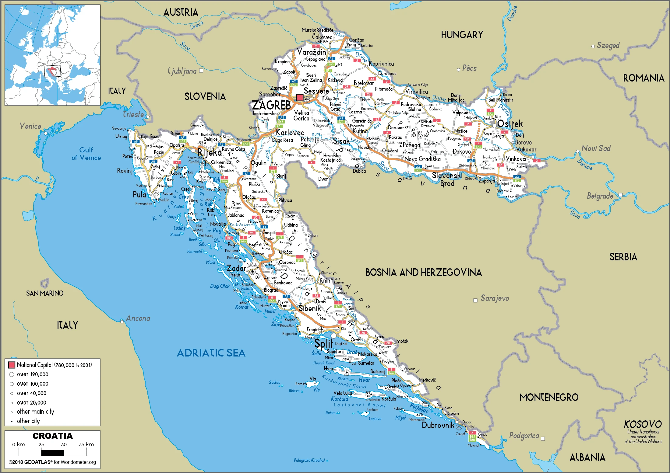
Administrative divisions: 20 counties (zupanije, zupanija – singular) and 1 city (grad – singular) with special county status; Bjelovarsko-Bilogorska (Bjelovar-Bilogora), Brodsko-Posavska (Brod-Posavina), Dubrovacko-Neretvanska (Dubrovnik-Neretva), Istarska (Istria), Karlovacka (Karlovac), Koprivnicko-Krizevacka (Koprivnica-Krizevci), Krapinsko-Zagorska (Krapina-Zagorje), Licko-Senjska (Lika-Senj), Medimurska (Medimurje), Osjecko-Baranjska (Osijek-Baranja), Pozesko-Slavonska (Pozega-Slavonia), Primorsko-Goranska (Primorje-Gorski Kotar), Sibensko-Kninska (Sibenik-Knin), Sisacko-Moslavacka (Sisak-Moslavina), Splitsko-Dalmatinska (Split-Dalmatia), Varazdinska (Varazdin), Viroviticko-Podravska (Virovitica-Podravina), Vukovarsko-Srijemska (Vukovar-Syrmia), Zadarska (Zadar), Zagreb, Zagrebacka (Zagreb county).
People and society
Croats are distinguished from Bosniaks and Serbs by their Roman Catholic faith and the Latin alphabet. Many Serbs fled Croatia during the early 1990s conflict that accompanied Yugoslavias breakup. Croatia’s entry into the EU, delayed by border disputes with Slovenia, finally occurred in 2013.
The population in Croatia is 4,208,973 (July 2021 estimate), with an average of -0.48% (2021 estimate) change. That means Croatia is the No. 127 in the world’s populated rank list. With an average of 43.9 years median age (42 years for males and 42 years for women), Croatia ranks No. 18 on the globe’s median age rank list.
The people living in this country are the Croat(s), Croatian(s) (noun) or Croatian (adjective) and belong mainly to the following ethnic groups: Croat 90.4%, Serb 4.4%, other 4.4% (including Bosniak, Hungarian, Slovene, Czech, and Romani), unspecified 0.8% (2011 estimate).
They speak Croatian (official language) 95.6%, Serbian 1.2%, other 3% (including Hungarian, Czech, Slovak, and Albanian), unspecified 0.2% (2011 estimate) languages and practice the following religions: Roman Catholic 86.3%, Orthodox 4.4%, Muslim 1.5%, other 1.5%, unspecified 2.5%, not religious or atheist 3.8% (2011 estimate).
We can conclude the following about the population in Croatia: More of the population lives in the northern half of the country, with approximately a quarter of the populace residing in and around the capital of Zagreb. Many of the islands are sparsely populated. In Croatia, we are talking about 57.9% (2021) of the total population is living in cities, and most of them reside in the following municipalities: 685,000 Zagreb (capital city) (2021).
Industry
The war cost an estimated $50 billion. Unemployment has been persistently high. Corruption deters foreign investment. Tourism is mainly on the Dalmatian coast. EU membership.
Though still one of the wealthiest of the former Yugoslav republics, Croatia’s economy suffered severely during the 1991-95 war. During that time, the country’s output collapsed, and Croatia missed the early waves of investment in Central and Eastern Europe that followed the fall of the Berlin Wall. Between 2000 and 2007, however, Croatia’s economic fortunes began to improve with moderate but steady GDP growth between 4% and 6%, led by a rebound in tourism and credit-driven consumer spending. Inflation over the same period remained tame, and the currency, the kuna, stable., Croatia experienced an abrupt slowdown in the economy in 2008; economic growth was stagnant or negative in each year between 2009 and 2014 but has picked up since the third quarter of 2014, ending 2017 with an average of 2.8% growth. Challenges remain, including uneven regional development, a challenging investment climate, an inefficient judiciary, and loss of educated young professionals seeking higher salaries elsewhere in the EU. In 2016, Croatia revised its tax code to stimulate domestic consumption and foreign investment growth. Income tax reduction began in 2017, and in 2018 various business costs were removed from income tax calculations.
At the start of 2018, the government announced its economic reform plan, slated for implementation in 2019. Tourism is one of the main pillars of the Croatian economy, comprising 19.6% of Croatia’s GDP. Croatia is becoming a regional energy hub and plans to open a floating liquefied natural gas (LNG) regasification terminal by 2019 or early in 2020 to import LNG for re-distribution in southeast Europe.
Following a decade-long accession process, Croatia joined the EU on July 1, July 2. Croatia has developed a plan for Eurozone accession, and the government projects Croatia will adopt the Euro by 2024. In 2017, the Croatian government decreased public debt to 78% of GDP, from an all-time high of 84% in 2014, and realized a 0.8% budget surplus – the first surplus since independence in 1991. The government has also sought to accelerate the privatization of non-strategic assets with mixed success. Croatia’s economic recovery is still somewhat fragile; Croatia’s largest private company narrowly avoided collapse in 2017, thanks to a capital infusion from an American investor. Restructuring is ongoing and projected to finish by mid-July 2018.
Croatia is rich in the following natural resources: Oil, some coal, bauxite, low-grade iron ore, calcium, gypsum, natural asphalt, silica, mica, clays, salt, hydropower.
The main industrial sectors are typically chemicals and plastics, machine tools, fabricated metal, electronics, pig iron, rolled steel products, aluminum, paper, wood products, construction materials, textiles, shipbuilding, petroleum, petroleum refining, food and beverages, tourism.
The country’s export sectors are particularly strong in refined petroleum, packaged medicines, cars, medical cultures/vaccines, lumber (2019), partnering with these nations: Italy 13%, Germany 13%, Slovenia 10%, Bosnia and Herzegovina 9%, Austria 6%, Serbia 5% (2019). The export trade resulted in $23.66 billion. Note: Data are in current year dollars (2020 estimate). In a global rank of the export, values resulted in Croatia’s position of 75.
Land use in Croatia: 34.4% (2018 estimate) forest, 41.9% (2018 estimate) other.
The arable land area is 16% (2018 estimate), and the agricultural land is 23.7% (2018 estimate). Land use for permanent crops 1.5% (2018 estimate), permanent pasture 6.2% (2018 estimate). The sum of the area of the irrigated land is 240 sq km (2012).
The main agro-industrial products of Croatia are maize, wheat, sugar beet, milk, barley, soybeans, potatoes, pork, grapes, sunflower seed.
The country typically needs to import: crude petroleum, cars, refined petroleum, packaged medicines, electricity (2019), partnering with the following nations: Italy 14%, Germany 14%, Slovenia 11%, Hungary 7%, Austria 6% (2019) in a sum value of $27.59 billion. Note: data are in current year dollars (2020 estimate) $31.39 billion. Note: data are in current year dollars (2019 estimate) $31.32 billion. Note: data are in current year dollars (2018 estimate). This sum value on the global ranking list of imports resulted in Croatia 72.
Croatia Driving Directions
In this post, you learned about Croatia, Southeastern Europe, bordering the Adriatic Sea, between Bosnia and Herzegovina and Slovenia. We published some basic information about its capital Zagreb, and the Croatian nation.
Are you interested in visiting Croatia and looking for driving directions? Click here to plan your route, or see a printable road map of Croatia below for an overview of the route network.
Printable map of Croatia
Did you know about Croatia?
Croatia is the second-largest country in the Balkans, and its capital city Zagreb is one of Europe’s greenest cities. Croatia offers a colorful cuisine rich in seafood, meats, and vegetables. Orthodox cathedrals, Roman temples, and Ottoman mosques are scattered throughout the country.
After virtually visiting Croatia, you may also be interested in the neighboring countries: Bosnia and Herzegovina, Hungary, Montenegro, Serbia, Slovenia.
If you liked our Google map and Croatia information page,
please share it with others or save the link https://www.drivingdirections.net in your bookmarks.