
Jersey Google Maps is a site/tool that offers a wide range of map views (topographic, satellite, street view) and navigation options, with little effort on your part, yet efficiently. If you need to plan a trip to a new place like Jersey, Google maps are available on desktop, mobile, or tablet. This Google maps and information page is dedicated to Jersey, Europe (47 countries), showing its location, country facts, details about its capital city Saint Helier, and plenty of other information which may be interesting when you visit this European state.
Quick links: Google Maps Jersey, Saint Helier Google maps, Driving Directions Jersey, Printable Road Map.
About Jersey in a nutshell
- Conventional short form of the name: Jersey
- The conventional long form of the name: Bailiwick of Jersey
- Former name(s): Norman Isles
- Etymology: the name is of Old Norse origin, but the meaning of the root Jer(s) is uncertain; the -ey ending means island.
- The legal system in Jersey: the laws of the UK apply where applicable; includes local statutes.
- Climate: Temperate, mild winters, and cool summers.
- The national symbols are Jersey cow; national colors: red, white.
- Internet TLD: .je
Background
Jersey and the other Channel Islands represent the last remnants of the medieval Duchy of Normandy that held sway in both France and England. These islands were the only British soil occupied by German troops in World War II. The Bailiwick of Jersey is a British Crown dependency, which means that it is not part of the UK but is instead a self-governing possession of the British Crown. However, the UK Government is constitutionally responsible for its defense and international representation.
Geography
Jersey is the largest of the Channel Islands in the English region of the island chain. The first people to settle on this island were Celts, but as waves of invaders arrived from Europe, it became inhabited by different peoples.
This state is located in Western Europe, an island in the English Channel, northwest of France, under the coordinates of 49 15 N, 2 10 W, covering an area of 116 sq km with a coastline of 70 km. Jersey is About two-thirds the size of Washington, DC.
Gently rolling plain with low, rugged hills along the north coast, with Les Platons 136 m as the highest point of Jersey, while the English Channel 0 m as the lowest point, causing a mean elevation at N/A throughout the country. With a total of 116 sq km, Jersey has 116 sq km of land and 0 sq km of water surface area.
Largest and southernmost of the Channel Islands; about 30% of the population is concentrated in Saint Helier.
The climate in Jersey is as follows: Temperate, mild winters, and cool summers.
The natural hazards shall be considered when you visit Jersey: Considerable tidal variation can be hazardous to navigation.
The following major health-threatening issues shall be considered when visiting Jersey: none.
Current environmental issues affecting the Channel Islander people: habitat and species depletion due to human encroachment; water pollution; improper solid waste disposal.
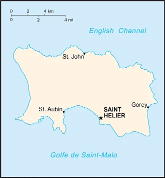
Google Maps Jersey
The capital and other divisions
Capital city: Saint Helier found under the coordinates 49 11 N, 2 06 W, applying the time zone UTC 0 (5 hours ahead of Washington, DC, during Standard Time), using the following daylight saving time: +1hr, begins last Sunday in March; ends last Sunday in October.
Saint Helier, known as Jersey, is the capital of the British territory in the Channel Islands. It is also one of its most populated cities, with approximately 52,000 residents.
Jersey became independent of none (British Crown dependency), and its national holiday is Liberation Day, 9 May (1945).
Administrative divisions: none (British crown dependency); there are no first-order administrative divisions as defined by the US Government, but there are 12 parishes; Grouville, Saint Brelade, Saint Clement, Saint Helier, Saint John, Saint Lawrence, Saint Martin, Saint Mary, Saint Ouen, Saint Peter, Saint Saviour, and Trinity.
People and society
The population in Jersey is 101,476 (July 2021 estimate), with an average of 0.67% (2021 estimate) change. That means Jersey is the No. 194 in the world’s populated rank list. With an average of 37.5 years median age (36 years for males and 36 years for women), Jersey ranks No. 70 on the globe’s median age rank list.
The people living in this country are the Channel Islander(s) (noun) or Channel Islander (adjective) and belong mainly to the following ethnic groups: Jersey 46.4%, British 32.7%, Portuguese/Madeiran 8.2%, Polish 3.3%, Irish, French, and other White 7.1%, other 2.4% (2011 estimate).
They speak English (official language) 94.5%, Portuguese 4.6%, other .9% (including French (official language) and Jerriais)(2001 estimate). Note: data represent the primary spoken language; the traditional language of Jersey is Jerriais or Jersey French (a Norman language), which fewer than 3,000 people spoke as of 2001. Two-thirds of Jerriais speakers are aged 60 and over languages and practice the following religions: Protestant (Anglican, Baptist, Congregational New Church, Methodist, Presbyterian), Roman Catholic.
We can conclude the following about the population in Jersey: Fairly even distribution. No notable trends. In Jersey, we are talking about 31% (2021) of the total population is living in cities, and most of them reside in the following municipalities: 34,000 Saint Helier (capital city) (2018).
Industry
Jersey’s economy is based on international financial services, agriculture, and tourism. In 2016, the financial services sector accounted for about 41% of the island’s output. Agriculture represented about 1% of Jersey’s economy in 2016. Potatoes are an important export crop, mainly shipped to the UK. The Jersey breed of dairy cattle originated on the island and is known worldwide. The dairy industry remains essential to the island, with approximately $8.8 million gallons of milk produced in 2015. Tourism accounts for a significant portion of Jersey’s economy, with more than 700,000 total visitors in 2015. Living standards come close to those of the UK. All raw material and energy requirements are imported, and Jersey’s food needs are a significant share. Light taxes and death duties make the island a famous offshore financial center. Jersey maintains its relationship with the EU through the UK. Therefore, in light of the UK’s decision to leave the EU, Jersey will also need to renegotiate its ties to the EU.
Jersey is rich in the following natural resources: Arable land.
The main industrial sectors are tourism, banking, finance, dairy, electronics.
The country’s export sectors are powerful in light industrial and electrical goods, dairy cattle, foodstuffs, textiles, flowers.
Land use in Jersey: 0% (2018 estimate) forest, 34% (2018 estimate) other.
The arable land area is 66% (2018 estimate), and the agricultural land is 66% (2018 estimate). Land use for permanent crops 0% (2018 estimate), permanent pasture 0% (2018 estimate). The sum of the area of the irrigated land is N/A.
The main agro-industrial products of Jersey are potatoes, cauliflower, tomatoes, beef, dairy products.
The country typically needs to import: machinery and transport equipment, manufactured goods, foodstuffs, mineral fuels, chemicals.
Jersey Driving Directions
In this post, you learned about Jersey, Western Europe, an island in the English Channel northwest of France. We published some basic information about its capital Saint Helier, and the Channel Islander nation.
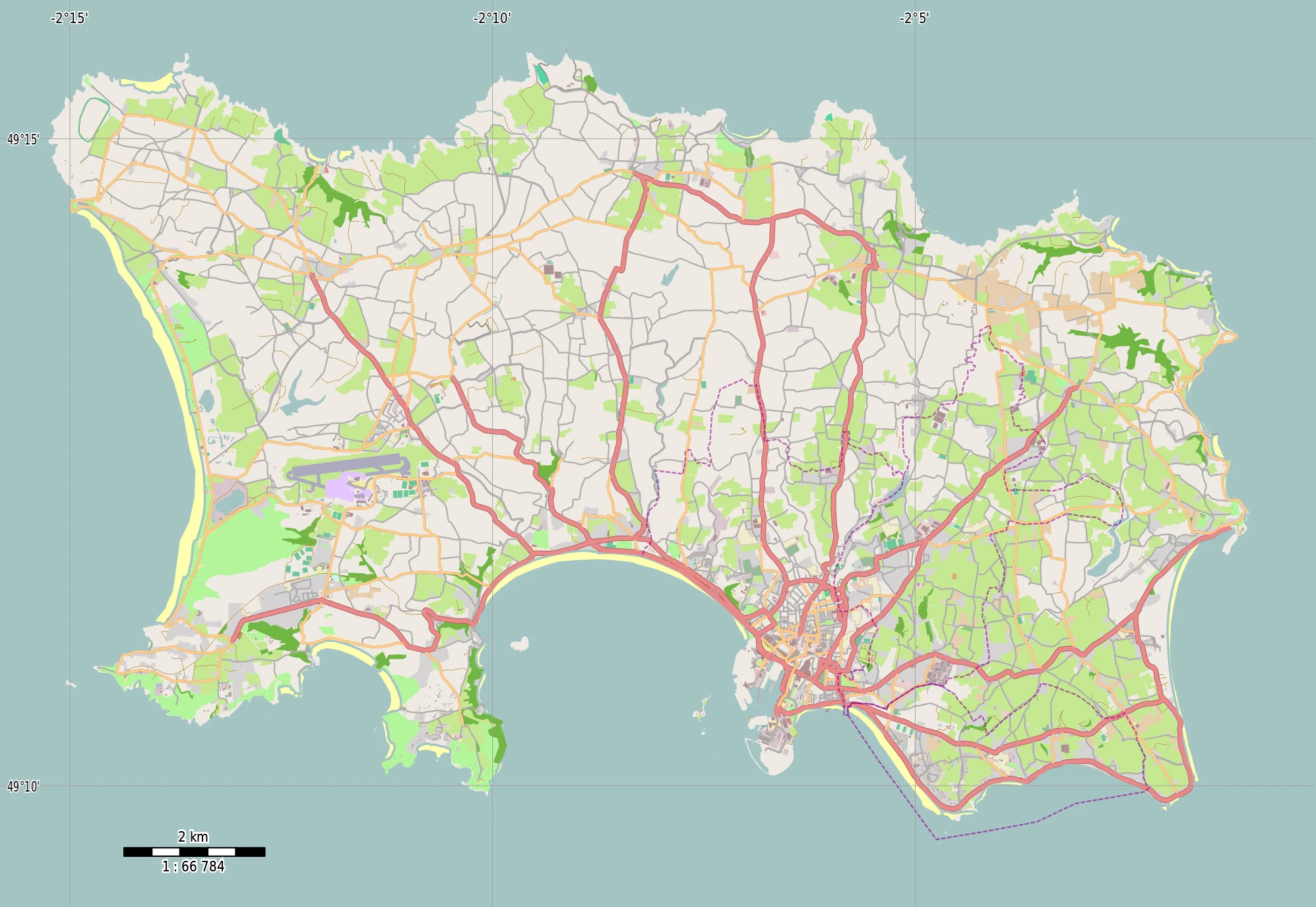
Are you interested in visiting Jersey and looking for driving directions? Click here to plan your route, or see a printable road map of Jersey below for an overview of the route network.
Printable map of Jersey
Did you know about Jersey?
On the island of Jersey, residents have their currency called JEQ. It is the islands’ official currency and is legal tender in Jersey. Jersey’s coins are exceptional in that they are made of copper-nickel, a mixture of copper and nickel.
After virtually visiting Jersey, you may also be interested in the neighboring countries: none.
If you liked our Google map and Jersey information page,
please share it with others or save the link https://www.drivingdirections.net in your bookmarks.