
Liechtenstein Google Maps is a site/tool that offers a wide range of map views (topographic, satellite, street view) and navigation options, with little effort on your part, yet efficiently. If you need to plan a trip to a new place like Liechtenstein, Google maps are available on desktop, mobile, or tablet. This Google maps and information page is dedicated to Liechtenstein, Europe (47 countries), showing its location, country facts, details about its capital city Vaduz, bordering countries like Austria, Switzerland, and plenty of other information that may be interesting when you visit this European state.
Quick links: Google Maps Liechtenstein, Vaduz Google maps, Driving Directions Liechtenstein, Printable Road Map.
About Liechtenstein in a nutshell
- Conventional short form of the name: Liechtenstein
- The conventional long form of the name: Principality of Liechtenstein
- Local long form: Fuerstentum Liechtenstein
- Local short form: Liechtenstein
- Former name(s): N/A
- Etymology: named after the Liechtenstein dynasty that purchased and united the counties of Schellenburg and Vaduz and that was allowed by the Holy Roman Emperor in 1719 to rename the new property after their family; the name in German means light (bright) stone.
- The legal system in Liechtenstein: civil law system influenced by Swiss, Austrian, and German law.
- Climate: Warm, dry summers. Winters are cold, with heavy snow in the mountains from December to March.
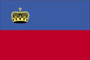
- The national symbols are princely hat (crown); national colors: blue, red.
- Internet TLD: .li
The tiny principality is one of only two states on Earth with no landlocked neighbors. The Rhine runs for 25 km along its western border, the snow-capped Rátikon rises to 2,600 meters in the southeast, and the broad floodplain of the once marshy but now cultivated Rhine lies to the north. Due to the specific topography, the climate is surprisingly mild and rainy and is influenced by frequent dry north-westerly winds from the south. The vegetation is dense and varied, with almost a third of the country covered by forest. Four-fifths of its inhabitants are descendants of the Germanic Alemanni, who settled here around 500 AD and spoke the Aleman dialect of German.
Liechtenstein’s economy uses Swiss money and is part of the Swiss customs union. Most of the mini-state’s tourist attractions are clustered around the intersection of two main streets in the ‘village-sized’ capital Vaduz. The temporary exhibitions of the State Art Collection present a selection of artworks collected over the centuries by the Princes of Liechtenstein. The Postage Stamp Museum has more than 300 galleries displaying stamps issued since 1912 – a significant part of the mini-state’s income still comes from stamp-issuing. Ski lovers can visit the Ski Museum before heading to the ski resort of Malbun in the southeast of the country. The local history museum in Trie-Senberg commemorates the Walser community who arrived from Switzerland in the 13th century.
Women in Liechtenstein obtained the vote only in 1984.
Background
The Principality of Liechtenstein was established within the Holy Roman Empire in 1719. Occupied by French and Russian troops during the Napoleonic Wars, it became a sovereign state in 1806 and joined the German Confederation in 1815. Liechtenstein became fully independent in 1866 when the Confederation dissolved. Until World War I, it was closely tied to Austria. Still, the economic devastation caused by that conflict forced Liechtenstein to enter into a customs and monetary union with Switzerland. Since World War II (in which Liechtenstein remained neutral), the country’s low taxes have spurred outstanding economic growth. In 2000, shortcomings in banking regulatory oversight resulted in concerns about the use of financial institutions for money laundering. However, Liechtenstein implemented anti-money laundering legislation and a Mutual Legal Assistance Treaty with the US that went into effect in 2003.
Geography
The upper Rhine Valley covers the western third of the country. The mountains and narrow valleys of the eastern Alps make up the remainder.
Perched in the Alps between Switzerland and Austria, the state of Liechtenstein became an independent principality of the Holy Roman Empire in 1719. It has close links with Switzerland.
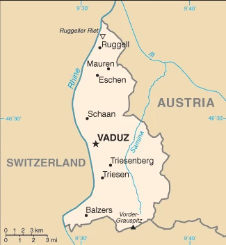
This state is located in Central Europe, between Austria and Switzerland, under the coordinates of 47 16 N, 9 32 E, covering an area of 160 sq km with a coastline of 0 km (landlocked country). Liechtenstein is About 0.9 times the size of Washington, DC.
Liechtenstein has 75 km of land boundaries and borders with (2 nations): Austria 34 km, Switzerland 41 km.
Mostly mountainous (alps) with rhine valley in western third, with Vorder-Grauspitz 2,599 m as the highest point of Liechtenstein, while Ruggeller Riet 430 m as the lowest point. With a total of 160 sq km, Liechtenstein has 160 sq km of land and 0 sq km water surface area.
Major water bodies in the country: The significant watersheds for Liechtenstein are Atlantic Ocean drainage: Rhine-Maas (198,735 sq km).
Along with Uzbekistan, one of only two doubly landlocked countries globally, a variety of microclimatic variations based on elevation.
The climate in Liechtenstein is as follows: Continental, cold, cloudy winters with frequent snow or rain, cool to moderately warm, cloudy, humid summers.
When you visit Liechtenstein, the natural hazards shall be considered: avalanches, landslides.
The following major health-threatening issues shall be considered when visiting Liechtenstein: none.
Current environmental issues affecting the Liechtenstein people: some air pollution generated locally, some transferred from surrounding countries.
Google Maps Liechtenstein
The capital and other divisions
Capital city: Vaduz found under the coordinates 47 08 N, 9 31 E, applying the time zone UTC+1 (6 hours ahead of Washington, DC, during Standard Time), using the following daylight saving time: +1hr begins last Sunday in March; ends last Sunday in October.
Vaduz is a small city, which from 1527-1797 was part of the Duchy of Liechtenstein (unlike the rest of the country) and was its administrative center. It’s located on the north-western shore of Lake Vaduz in the Kiental valley.
Liechtenstein became independent on 23 January 1719 (Principality of Liechtenstein established); 12 July 1806 (independence from the Holy Roman Empire); 24 August 1866 (independence from the German Confederation), and its national holiday is National Day, 15 August (1940);.
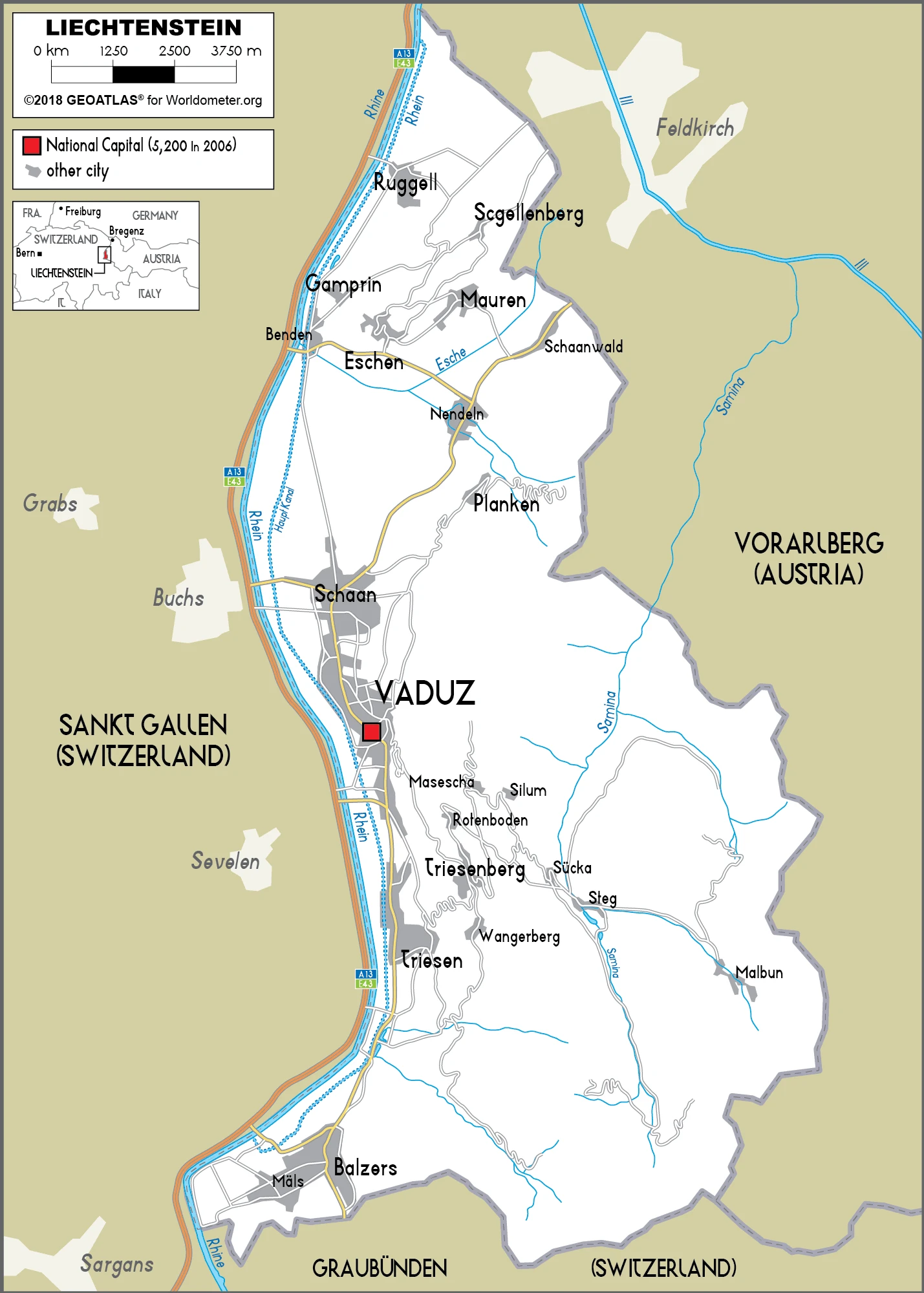
Administrative divisions: 11 communes (Gemeinden, singular – Gemeinde); Balzers, Eschen, Gamprin, Mauren, Planken, Ruggell, Schaan, Schellenberg, Triesen, Triesenberg, Vaduz.
People and society
The principalitys role as a financial center accounts for many foreign residents (a third of the population). Half of the workforce is cross-border commuters. Living standards are high, with few social tensions. Linked by a customs union since 1924, Switzerland handles Liechtensteins foreign affairs and defense issues.
The population in Liechtenstein is 39,425 (July 2021 estimate). Note: immigrants make up 67% of the total population, according to UN data (2019), with an average of 0.73% (2021 estimate) change. That means Liechtenstein is the No. 212 in the world’s populated rank list. With an average of 43.7 years median age (42 years for males and 42 years for women), Liechtenstein ranks No. 22 on the globe’s median age rank list.
The people living in this country are the Liechtensteiner(s) (noun) or Liechtenstein (adjective) and belong mainly to the following ethnic groups: Liechtensteiner 65.8%, Swiss 9.6%, Austrian 5.9%, German 4.4%, Italian 3.1%, other 11.2% (2019 estimate). Note: data represent population by nationality.
They speak German 91.5% (official language) (Alemannic is the main dialect), Italian 1.5%, Turkish 1.3%, Portuguese 1.1%, other 4.6% (2015 estimate) languages and practice the following religions: Roman Catholic (official) 73.4%, Protestant Reformed 6.3%, Muslim 5.9%, Christian Orthodox 1.3%, Lutheran 1.2%, other Protestant .7%, other Christian .3%, other .8%, none 7%, unspecified 3.3% (2015 estimate).
We can conclude the following about the population in Liechtenstein: Most of the population is found in the western half of the country along the rhine river. In Liechtenstein, we are talking about 14.5% (2021) of the total population is living in cities, and most of them reside in the following municipalities: 5,000 Vaduz (capital city) (2018).
Industry
Banking secrecy (now modified) and low taxes help attract foreign investment. Anti-money-laundering rules are recent. Diversified exports include precision instruments, dental products, and chemicals.
Despite its small size and lack of natural resources, Liechtenstein has developed into a prosperous, highly industrialized, free-enterprise economy with a vital financial services sector and one of its highest per capita income levels. The Liechtenstein economy is widely diversified, with many small and medium-sized businesses, particularly in the services sector. Low business taxes – a flat tax of 12.5% on income is applied – and easy incorporation rules have induced many holding companies to establish nominal offices in Liechtenstein, providing 30% of state revenues. The country participates in a customs union with Switzerland and uses the Swiss franc as its national currency. It imports more than 90% of its energy requirements. Liechtenstein has been a member of the European Economic Area (an organization serving as a bridge between the European Free Trade Association and the EU) since May 1995.
The government is working to harmonize its economic policies with those of an integrated EU. As of 2015, 54% of Liechtenstein’s workforce consisted of cross-border commuters, mainly from Austria, Germany, and Switzerland. Since 2008, Liechtenstein has faced renewed international pressure – particularly from Germany and the US – to improve transparency in its banking and tax systems. In December 2008, Liechtenstein signed a Tax Information Exchange Agreement with the US. Upon Liechtenstein’s conclusion of 12 bilateral information-sharing agreements, the OECD in October 2009 removed the principality from its grey list of countries that had yet to implement the organization’s Model Tax Convention. By the end of 2010, Liechtenstein had signed 25 Tax Information Exchange Agreements or Double Tax Agreements. In 2011, Liechtenstein joined the Schengen area, allowing passport-free travel across 26 European countries. In 2015, Liechtenstein and the EU agreed to clamp down on tax fraud and evasion and, in 2018, will start automatically exchanging information on the bank accounts of each other’s residents.
Liechtenstein is rich in the following natural resources: Hydroelectric potential, arable land.
The main industrial sectors are electronics, metal manufacturing, dental products, ceramics, pharmaceuticals, food products, precision instruments, tourism, optical instruments.
The country’s export sectors are potent in small specialty machinery, connectors for audio and video, parts for motor vehicles, dental products, hardware, prepared foodstuffs, electronic equipment, optical products. The export trade resulted in $3.217 billion. Note: Data are in current year dollars (2015 estimate). In a global rank of the export, values resulted in Liechtenstein’s position of 143.
Land use in Liechtenstein: 43.1% (2018 estimate) forest, 19.3% (2018 estimate) other.
The arable land area is 18.8% (2018 estimate), and the agricultural land is 37.6% (2018 estimate). Land use for permanent crops 0% (2018 estimate), permanent pasture 18.8% (2018 estimate). The sum of the area of the irrigated land is 0 sq km (2012).
The main agro-industrial products of Liechtenstein are wheat, barley, corn, potatoes; livestock, dairy products.
The country typically needs to import: agricultural products, raw materials, energy products, machinery, metal goods, textiles, foodstuffs, motor vehicles, partnering with the following nations in a sum value of $2.23 billion (2014 estimate). Note: trade data exclude trade with Switzerland. This sum value on the global ranking list of imports resulted in Liechtenstein 173.
Liechtenstein Driving Directions
In this post, you learned about Liechtenstein, Central Europe, between Austria and Switzerland. We published some basic information about its capital Vaduz, and the Liechtenstein nation.
Are you interested in visiting Liechtenstein and looking for driving directions? Click here to plan your route, or see a printable road map of Liechtenstein below for an overview of the route network.
Printable map of Liechtenstein
Did you know about Liechtenstein?
Liechtenstein is a very small country located in Europe. It has the third-highest GDP per capita globally and is known for its banking sector. The country also offers many outdoor activities, including skiing, hiking, and biking.
After virtually visiting Liechtenstein, you may also be interested in the neighboring countries: Austria, Switzerland.
If you liked our Google map and Liechtenstein information page,
please share it with others or save the link https://www.drivingdirections.net in your bookmarks.