
Montserrat Google Maps is a site/tool that offers a wide range of map views (topographic, satellite, street view) and navigation options, with little effort on your part, yet efficiently. If you need to plan a trip to a new place like Montserrat, Google maps are available on desktop, mobile, or tablet. This Google maps and information page is dedicated to Montserrat, Central America, and the Caribbean (35 countries), showing its location, country facts, details about its capital city Plymouth, and plenty of other information which may be interesting when you visit this Central American and the Caribbean state.
Quick links: Google Maps Montserrat, Plymouth Google maps, Driving Directions Montserrat, Printable Road Map.
About Montserrat in a nutshell
- Conventional short form of the name: Montserrat
- The conventional long form of the name: none
- Etymology: island named by explorer Christopher COLUMBUS in 1493 after the Benedictine abbey Santa Maria de Montserrat, near Barcelona, Spain.
- The legal system in Montserrat: English common law.
- Climate: Tropical, with little daily or seasonal temperature variation.
- The national symbols are N/A.
- Internet TLD: .ms
Background
English and Irish colonists from St. Kitts first settled on Montserrat in 1632. The first enslaved Africans arrived three decades later. The British and French fought for possession of the island for most of the 18th century, but it finally was confirmed as a British possession in 1783. The island’s sugar plantation economy was converted to small farm landholdings in the mid-19th century. Much of this island was devastated, and two-thirds of the population fled abroad because of the eruption of the Soufriere Hills Volcano that began on 18 July 1995. Montserrat has endured volcanic activity since, with the last eruption occurring in 2013.
Geography
Montserrat is a small, mountainous island in the Caribbean Sea. It has a rich and diverse culture, history, and natural beauty.
This state is located on the Caribbean, an island in the Caribbean Sea, southeast of Puerto Rico, under the coordinates of 16 45 N, 62 12 W, covering an area of 102 sq km with a coastline of 40 km. Montserrat is About 0.6 times the size of Washington, DC.
A volcanic island, mostly mountainous, with minor coastal lowland, with Soufriere hills volcano pre-eruption height, was 915 m; current lava dome is subject to periodic build-up and collapse; estimated dome height was 1,050 m in 2015 as the highest point of Montserrat, while the Caribbean Sea 0 m as the lowest point. With a total of 102 sq km, Montserrat has 102 sq km of land and 0 sq km of water surface area.
The island is entirely volcanic in origin and comprises three major volcanic centers of differing ages.
The climate in Montserrat is as follows: Tropical, with slight daily or seasonal temperature variation.
When you visit Montserrat, the natural hazards shall be considered: Volcanic eruptions; severe hurricanes (June to November) volcanism: Soufriere Hills volcano (915 m) has erupted continuously since 1995; a massive eruption in 1997 destroyed most of the capital, Plymouth, and resulted in approximately half of the island becoming uninhabitable; the island of Montserrat is part of the volcanic island arc of the lesser Antilles that extends from saba in the north to Grenada in the south.
The following major health-threatening issues shall be considered when visiting Montserrat: none.
Current environmental issues affecting the Montserratian people: land erosion occurs on slopes that have been cleared for cultivation.
Google Maps Montserrat
The capital and other divisions
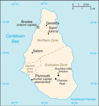
Capital city: Plymouth found under the coordinates 16 42 N, 62 13 W, applying the time zone UTC-4 (1 hour ahead of Washington, DC, during Standard Time), using the following daylight saving time: none.
Plymouth is located on the southern shore of Montserrat. It includes Plymouth City, Plymouth Parish, and Woodbury Harbour. People from Britain, Ireland settled in Plymouth and Africa to protect against pirates. Many museums and historical sites, including cannons that came over on the Mayflower and other famous pioneers, started their journeys here.
Montserrat became independent of none (overseas territory of the UK). Its national holiday is the Birthday of Queen ELIZABETH II, usually celebrated the Monday after the second Saturday in June (1926).
Administrative divisions: 3 parishes; Saint Anthony, Saint Georges, Saint Peter.
People and society
The population in Montserrat is 5,387 (July 2021 estimate). Note: an estimated 8,000 refugees left the island following the resumption of volcanic activity in July 1995; some have returned, with an average of 0.52% (2021 estimate) change. That means Montserrat is the No. 226 in the world’s populated rank list. With an average of 34.8 years median age (34.1 years for males and 34.1 years for women), Montserrat ranks No. 88 on the globe’s median age rank list.
The people living in this country are the Montserratian(s) (noun) or Montserratian (adjective) and belong mainly to the following ethnic groups: African/Black 86.2%, mixed 4.8%, Hispanic/Spanish 3%, Caucasian/White 2.7%, East Indian/Indian 1.6%, other 1.8% (2018 estimate).
They speak English languages and practice the following religions: Protestant 71.4% (includes Anglican 17.7%, Pentecostal/Full Gospel 16.1%, Seventh Day Adventist 15%, Methodist 13.9%, Church of God 6.7%, other Protestant 2%), Roman Catholic 11.4%, Rastafarian 1.4%, Hindu 1.2%, Jehovahs Witness 1%, Muslim 0.4%, other/not stated 5.1%, none 7.9% (2018 estimate).
We can conclude the following about the population in Montserrat: Only the northern half of the island is populated, the southern portion is uninhabitable due to volcanic activity. In Montserrat, we are talking about 9.2% (2021) of the total population is living in cities.
Industry
Severe volcanic activity, which began in July 1995, has put a damper on this small, open economy. A catastrophic eruption in June 1997 closed the airport and seaports, causing further economic and social dislocation. Two-thirds of the 12,000 inhabitants fled the island. Some began to return in 1998, but lack of housing limited the number. The agriculture sector continued to be affected by the lack of suitable land for farming and the destruction of crops. Prospects for the economy depend largely on developments in volcanic activity and public sector construction activity. Half of the island remains uninhabitable. In January 2013, the EU announced the disbursement of a $55.2 million aid package to Montserrat to boost the country’s economic recovery, with a specific focus on public finance management, public sector reform, and prudent economic management. Montserrat is tied to the EU through the UK. Although the UK is leaving the EU, Montserrat’s aid will not be affected as Montserrat maintains a direct agreement with the EU regarding aid.
The main industrial sectors are typically tourism, rum, textiles, electronic appliances.
The country’s export sectors are particularly strong in the sand, iron products, seats, medical instruments, fish (2019), partnering with these nations: Antigua and Barbuda 19%, United States 18%, France 17%, Singapore 14%, Belgium 9%, Netherlands 5% (2019). The export trade resulted in $4.4 million. Note: Data are in current year dollars (2017 estimate). In a global rank of the export, values resulted in Montserrat’s position of 222.
Land use in Montserrat: 25% (2018 estimate) forest, 45% (2018 estimate) other.
The arable land area is 20% (2018 estimate), and the agricultural land is 30% (2018 estimate). Land use for permanent crops 0% (2018 estimate), permanent pasture 10% (2018 estimate). The sum of the area of the irrigated land is 0 sq km (2012).
The main agro-industrial products of Montserrat are cabbages, carrots, cucumbers, tomatoes, onions, peppers, livestock products.
The country typically needs to import: refined petroleum, cars, oranges, electric motors, broadcasting equipment (2019), partnering with the following nations: the United States 70%, United Kingdom 6% (2019) in a sum value of $39.44 million (2017 estimate) $36.1 million (2016 estimate). This sum value on the global ranking list of imports resulted in Montserrat 223.
Montserrat Driving Directions
In this post, you learned about Montserrat, a Caribbean island southeast of Puerto Rico. We published some basic information about its capital Plymouth, and the Montserratian nation.
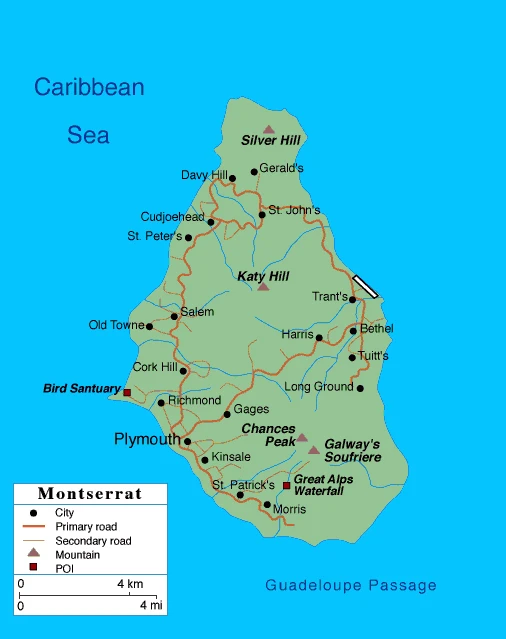
Are you interested in visiting Montserrat and looking for driving directions? Click here to plan your route, or see a printable road map of Montserrat below for an overview of the route network.
Printable map of Montserrat
Did you know about Montserrat?
Montserrat is an island in the Caribbean region of the kingdom of Spain. The island has been home to humans for centuries, but it was largely abandoned in 1997 when Montserrat’s Soufriere Hills Volcano erupted. Montserrat consists of an old side and a new side. The new site contains a few hundred people who live in and around Plymouth, also home to the capital city Brades.
After virtually visiting Montserrat, you may also be interested in Spain.
If you liked our Google map and Montserrat information page,
please share it with others or save the link https://www.drivingdirections.net in your bookmarks.