
Pakistan Google Maps is a site/tool that offers a wide range of map views (topographic, satellite, street view) and navigation options, with little effort on your part, yet efficiently. If you need to plan a trip to a new place like Pakistan, Google maps are available on desktop, mobile, or tablet. This Google maps and information page is dedicated to Pakistan, Asia (22 countries), showing its location, country facts, details about its capital city Islamabad, bordering countries like Afghanistan, China, India, Iran, and plenty of other information which may be interesting when you visit this Asian state.
Quick links: Google Maps Pakistan, Islamabad Google maps, Driving Directions Pakistan, Printable Road Map.
About Pakistan in a nutshell
- Conventional short form of the name: Pakistan
- The conventional long form of the name: Islamic Republic of Pakistan
- Local long form: Jamhuryat Islami Pakistan
- Local short form: Pakistan
- Former name(s): West Pakistan
- Etymology: the word pak means pure in Persian or Pashto, while the Persian suffix -stan means place or country, so the word Pakistan means Land of the Pure.
- The legal system in Pakistan: common law system with Islamic law influence.
- Climate: Temperatures can soar to 122°F (50°C) in the south and west and fall to 4°F (20°C) in the Hindu Kush.
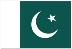
- The national symbols are a five-pointed star between the horns of a waxing crescent moon, jasmine; national colors: green and white.
- Internet TLD: .pk
A multi-ethnic country, Pakistan has always been much more than a transit point for the caravan from the Middle East to India – as its world heritage proves. Mohenjodaro was the center of the Indus Valley civilization in the 3rd and 2nd millennia BC. Taxila is the most important archaeological site in the north of the country, the ‘Troy of Pakistan’: three cities were built here, one on top of the other, from the Neolithic period to the 2nd century A.D. Taxila was a center of Buddhist teaching for seven centuries, as was the monastery of Bakhti in Takth, founded in the 1st century A.D. The fortress of Rohtas, the necropolis of Thatta, the capital of the three dynasties of the Sindh-Viddh, the fortress of Lahore, and the hanging gardens of Shalamar are monuments of Islamic Mughal architecture from the 14th to 18th centuries.
In 1988, Pakistan elected Benazir Bhutto as the first female prime minister in the Muslim world.
Background
The Indus Valley civilization, one of the oldest globally and dating back at least 5,000 years, spread over much of what is presently Pakistan. During the second millennium B.C., remnants of this culture fused with the migrating Indo-Aryan peoples. In subsequent centuries, the area underwent successive invasions from the Persians, Greeks, Scythians, Arabs (who brought Islam), Afghans, and Turks. The Mughal Empire flourished in the 16th and 17th centuries. The British came to dominate the region in the 18th century. The separation in 1947 of British India into the Muslim state of Pakistan (with West and East sections) and predominantly Hindu India was never satisfactorily resolved, and India and Pakistan fought two wars and a limited conflict – in 1947-48, 1965, and 1999 respectively – over the disputed Kashmir territory. A third war between these countries in 1971 – in which India assisted an indigenous movement reacting to the marginalization of Bengalis in Pakistani politics – resulted in East Pakistan becoming the separate nation of Bangladesh. In response to Indian nuclear weapons testing, Pakistan conducted its tests in mid-1998. India-Pakistan relations improved in the mid-2000s but have been rocky since the November 2008 Mumbai attacks and have been further strained by attacks in India by militants believed to be based in Pakistan. Imran KHAN took office as prime minister in 2018 after the Pakistan Tehreek-e-Insaaf (PTI) party won a plurality of seats in the July 2018 general elections. Pakistan has been engaged in a decades-long armed conflict with militant groups that target government institutions and civilians, including the Tehreek-e-Taliban Pakistan (TTP) and other militant networks.
Geography
Indus floodplain across east and south. Hindu Kush mountains in the north. Semidesert plateau, mountains in the west.
Once a part of British India, Pakistan was created in 1947 in response to demands for an independent Muslim state. In 1971, Bangladesh (former East Pakistan) became a separate state.
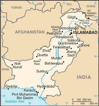
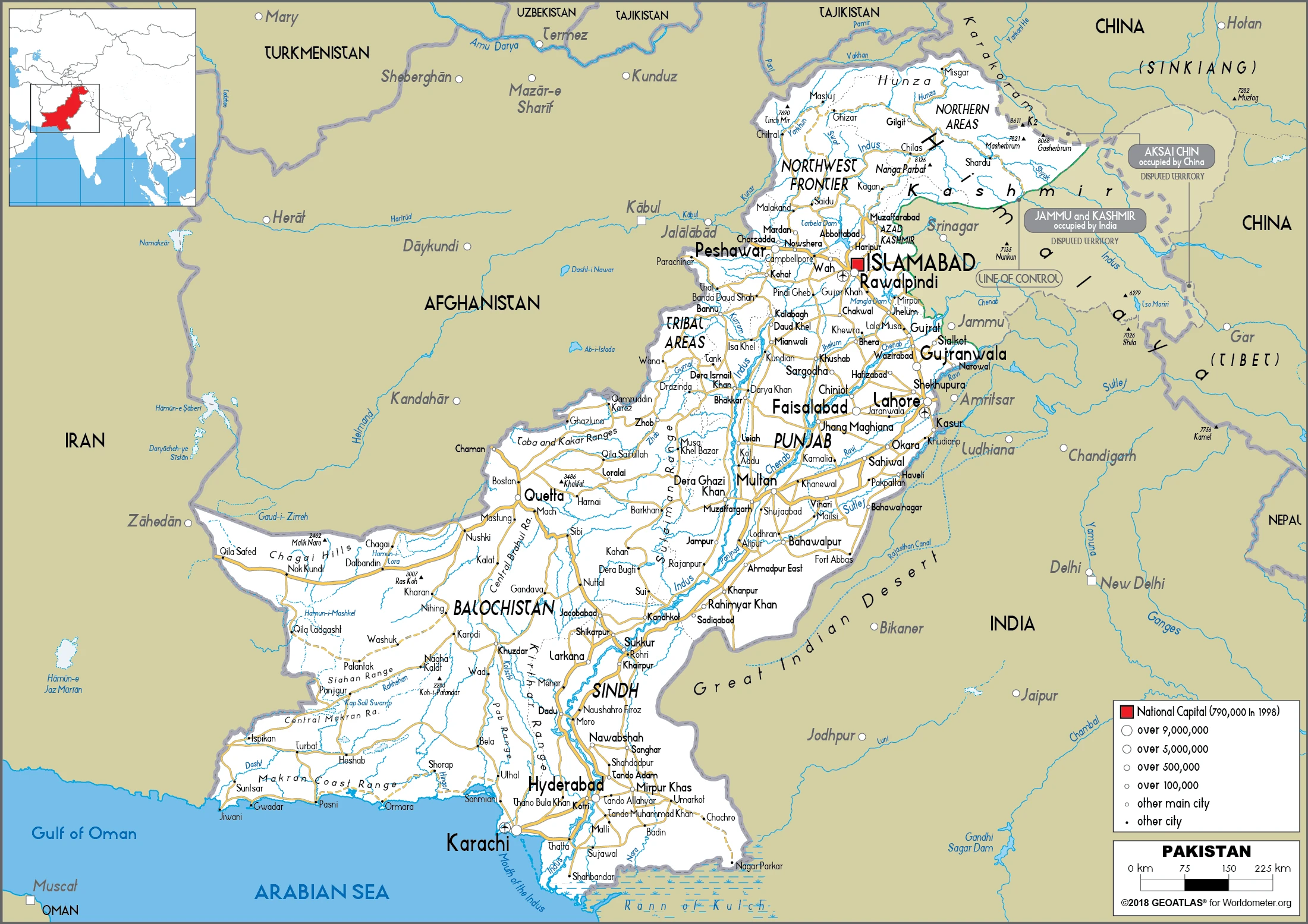
This state is located in Southern Asia, bordering the Arabian Sea, between India on the east and Iran and Afghanistan on the west, and China in the north, under the coordinates of 30 00 N, 70 00 E, covering an area of 796,095 sq km with a coastline of 1,046 km. Pakistan is Slightly more than five times the size of Georgia; slightly less than twice the size of California.
Pakistan has 7,257 km of land boundaries and borders (4 nations): Afghanistan 2670 km, China 438 km, India 3190 km, and Iran 959 km.
Divided into three major geographic areas: the northern highlands, the Indus River plain in the center and east, and the Balochistan plateau in the south and west, with K2 (mt. Godwin-Austen) 8,611 m as the highest point of Pakistan, while the Arabian Sea 0 m as the lowest point, causing a mean elevation at 900 m throughout the country. With a total of 796,095 sq km, Pakistan has 770,875 sq km of land and 25,220 sq km of water surface area.
The major rivers are: Indus (shared with India and China) – 3,610 km, Sutlej (shared with India) – 1,372 km, Chenab (shared with India) – 1,086 km. The significant watersheds for Pakistan are Indian Ocean drainage: Indus (1,081,718 sq km) Internal (endorheic basin) drainage: Tarim Basin (1,152,448 sq km), (Aral Sea basin) Amu Darya (534,739 sq km).
Controls Khyber Pass and Bolan Pass, traditional invasion routes between Central Asia and the Indian Subcontinent.
The climate in Pakistan is primarily hot, desert, temperate in the northwest, and arctic in the north.
When you visit Pakistan, the natural hazards shall be considered: Frequent earthquakes, occasionally severe, especially in the north and west; flooding along the Indus after heavy rains (July and August).
The following major health-threatening issues shall be considered when visiting Pakistan: degree of risk: high (2020), bacterial diarrhea, hepatitis A and E, typhoid fever, dengue fever and malaria, and rabies.
Current environmental issues affecting the Pakistani people: water pollution from raw sewage, industrial wastes, and agricultural runoff; limited natural freshwater resources; most of the population does not have access to potable water; deforestation; soil erosion; desertification; air pollution and noise pollution in urban areas.
Google Maps Pakistan
The capital and other divisions
Capital city: Islamabad found under the coordinates 33 41 N, 73 03 E, applying the time zone UTC+5 (10 hours ahead of Washington, DC, during Standard Time), using the following daylight saving time: none.
Islamabad is known as the political heart of Pakistan, and it has historically been the capital of Pakistan. It is a city with a rich culture and many historical sites, such as the Quaid-e-Azam’s Mausoleum. It is also home to many modern landmarks due to migration trends in recent years. It is located in the northwest of Pakistan, near the border with China and Afghanistan. The city’s name comes from “Islami ka Sher” which means “City of Islam,” and was founded in 1542 by Prince back from a military campaign into what is now called Pakistan and India.
Pakistan became independent on 14 August 1947 (from British India), and its national holiday is Pakistan Day (also referred to as Pakistan Resolution Day or Republic Day), 23 March (1940).
Administrative divisions: 4 provinces, 2 Pakistan-administered areas, and 1 capital territory; Azad Kashmir, Balochistan, Gilgit-Baltistan, Islamabad Capital Territory, Khyber Pakhtunkhwa, Punjab, Sindh.
People and society
Punjabis dominate government and the army. Tensions with minority groups are exacerbated by the vast gap between rich and poor. Strong family ties permeate politics and business. Relations with India are tense over Kashmir and terrorism. Islamist Taliban insurgency in tribal areas on Afghan border: fighting has displaced millions.
The population in Pakistan is 238,181,034 (July 2021 estimate). Note: provisional results of Pakistan’s 2017 national census estimate the country’s total population to be 207,774,000, with an average of 1.99% (2021 estimate) change. That means Pakistan is the No. 5 in the world’s populated rank list. With an average of 22 years median age (21.9 years for males and 21.9 years for women), Pakistan ranks No. 180 on the globe’s median age rank list.
The people living in this country are the Pakistani(s) (noun) or Pakistani (adjective) and belong mainly to the following ethnic groups: Punjabi 44.7%, Pashtun (Pathan) 15.4%, Sindhi 14.1%, Saraiki 8.4%, Muhajirs 7.6%, Balochi 3.6%, other 6.3%.
They speak Punjabi 48%, Sindhi 12%, Saraiki (a Punjabi variant) 10%, Pashto (alternate name, Pashtu) 8%, Urdu (official language) 8%, Balochi 3%, Hindko 2%, Brahui 1%, English (official language; lingua franca of Pakistani elite and most government ministries), Burushaski, and other 8% languages and practice the following religions: Muslim (official) 96.5% (Sunni 85-90%, Shia 10-15%), other (includes Christian and Hindu) 3.5% (2020 estimate).
We can conclude the following about the population in Pakistan: The Indus River and its tributaries attract most of the settlements, with Punjab province the most densely populated. In Pakistan, we talk about 37.4% (2021) of the total population lives in cities. Most of them reside in the following municipalities: 16.459 million, Karachi, 13.095 million, Lahore, 3.542 million, Faisalabad, 2.281 million, Rawalpindi, 2.290 million, Gujranwala, 1.164 million, Islamabad (capital city) (2021).
Industry
Major cotton and rice producers, but unpredictable weather conditions often affect crops. Textiles. Instability. Corruption. Aid to fight terrorism and for earthquake reconstruction.
Decades of internal political disputes and low levels of foreign investment have led to underdevelopment in Pakistan. Pakistan has a large English-speaking population, with English-language skills less prevalent outside urban centers. However, some progress in recent years in both security and energy, a challenging security environment, electricity shortages, and a burdensome investment climate have traditionally deterred investors. Agriculture accounts for one-fifth of output and two-fifths of employment. Textiles and apparel account for more than half of Pakistan’s export earnings; Pakistan’s failure to diversify its exports has made it vulnerable to shifts in world demand. Pakistan’s GDP growth has gradually increased since 2012 and was 5.3% in 2017. Official unemployment was 6% in 2017, but this fails to capture the accurate picture because much of the economy is informal, and underemployment remains high. Human development continues to lag behind most of the region.
In 2013, Pakistan embarked on a $6.3 billion IMF Extended Fund Facility, which focused on reducing energy shortages, stabilizing public finances, increasing revenue collection, and improving its balance of payments position. The program concluded in September 2016. Although Pakistan missed several structural reform criteria, it restored macroeconomic stability, improved its credit rating, and boosted growth. The Pakistani rupee has remained relatively stable against the US dollar since 2015, though it declined about 10% between November 2017 and March 2018. However, the balance of payments concerns has reemerged due to a significant increase in imports and weak export and remittance growth. Pakistan must continue to address several longstanding issues, including expanding investment in education, healthcare, and sanitation, adapting to the effects of climate change and natural disasters, improving the country’s business environment, and widening the country’s tax base. Given demographic challenges, Pakistan’s leadership will be pressed to implement economic reforms, promote further development of the energy sector, and attract foreign investment to support sufficient economic growth necessary to employ its growing and rapidly urbanizing population, much of which is under the age of 25. Pakistan and China implemented the China-Pakistan Economic Corridor (CPEC) with $60 billion in investments targeted toward energy and other infrastructure projects to boost development. Pakistan believes CPEC investments will enable growth rates of over 6% of GDP by laying the groundwork for increased exports. CPEC-related obligations have raised IMF concern about Pakistan’s capital outflows and external financing needs over the medium term.
Pakistan is rich in the following natural resources: Arable land, extensive natural gas reserves, limited petroleum, poor quality coal, iron ore, copper, salt, and limestone.
The main industrial sectors are textiles and apparel, food processing, pharmaceuticals, surgical instruments, construction materials, paper products, fertilizer, and shrimp.
The country’s export sectors are robust in textiles, clothing and apparel, rice, leather goods, and surgical instruments (2019), partnering with these nations: the United States 14%, China 8%, Germany 7%, the United Kingdom 6% (2019). The export trade resulted in $27.3 billion. Note: Data are in current year dollars (2020 estimate). In a global rank of the export, values resulted in Pakistan’s position of 72.
Land use in Pakistan: 2.1% (2018 estimate) forest, 62.7% (2018 estimate) other.
The arable land area is 27.6% (2018 estimate), and the agricultural land is 35.2% (2018 estimate). Land use for permanent crops 1.1% (2018 estimate), permanent pasture 6.5% (2018 estimate). The sum of the area of the irrigated land is 202,000 sq km (2012).
The main agro-industrial products of Pakistan are sugar cane, buffalo milk, wheat, milk, rice, maize, potatoes, cotton, fruit, and mangoes/guavas.
The country typically needs to import: refined petroleum, crude petroleum, natural gas, palm oil, and scrap iron (2019), partnering with the following nations: China 28%, the United Arab Emirates 11%, the United States 5% (2019) in a sum value of $51.07 billion. Note: data are in current year dollars (2020 estimate) $57.98 billion. Note: data are in current year dollars (2019 estimate) $68.42 billion. Note: data are in current year dollars (2018 estimate). This sum value on the global ranking list of imports resulted in Pakistan 60.
Pakistan Driving Directions
In this post, you learned about Pakistan, Southern Asia, bordering the Arabian Sea, between India on the east and Iran and Afghanistan on the west, and China in the north. We published some basic information about its capital Islamabad, and the Pakistani nation.
Are you interested in visiting Pakistan and looking for driving directions? Click here to plan your route, or see a printable road map of Pakistan below for an overview of the route network.
Printable map of Pakistan
Did you know about Pakistan?
Pakistan is a fascinating country with a long and complicated history. It’s a landlocked country located in South Asia and has over 238 million people. Pakistan was founded in 1947 after the partition of British India into Hindu and Muslim territories. Since then, it has experienced many political changes, including a military coup in 1958, a civil war in 1971, and a series of tribal conflicts that continue to this day.
Pakistan has a rich culture and history and is known for its mountains, deserts, and lush green valleys. It is also home to many major cities, including Karachi, Lahore, Islamabad, Rawalpindi, Peshawar, and Quetta.
After virtually visiting Pakistan, you may also be interested in the neighboring countries: Afghanistan, China, India, and Iran.
If you liked our Google map and Pakistan information page,
please share it with others or save the link https://www.drivingdirections.net in your bookmarks.