
Puerto Rico Google Maps is a site/tool that offers a wide range of map views (topographic, satellite, street view) and navigation options, with little effort on your part, yet efficiently. If you need to plan a trip to a new place like Puerto Rico, Google maps are available on desktop, mobile, or tablet. This Google maps and information page is dedicated to Puerto Rico, Central America, and the Caribbean (35 countries), showing its location, country facts, details about its capital city San Juan, bordering countries like none, and plenty of other information which may be interesting when you visit this Central American and the Caribbean state.
Quick links: Google Maps Puerto Rico, San Juan Google maps, Driving Directions Puerto Rico, Printable Road Map.
About Puerto Rico in a nutshell
- Conventional short form of the name: Puerto Rico
- The conventional long form of the name: Commonwealth of Puerto Rico
- Former name(s): N/A
- Etymology: Christopher COLUMBUS named the island San Juan Bautista (Saint John the Baptist) and the capital city and main port Cuidad de Puerto Rico (Rich Port City); over time, however, the names were shortened and transposed, and the island became to be called Puerto Rico, and it’s capital San Juan.
- The legal system in Puerto Rico: civil law system based on the Spanish civil code and within the framework of the US federal system.
- Climate: Tropical marine, mild; little seasonal temperature variation.
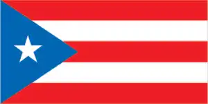
- The national symbols are Puerto Rican Spindalis (bird) and Coqui (frog). The national colors are red, white, and blue.
- Internet TLD: .pr
Background
Populated for centuries by aboriginal peoples, the Spanish Crown claimed the island in 1493 following Christopher COLUMBUS’s second voyage to the Americas. In 1898, after 400 years of colonial rule that saw the indigenous population nearly exterminated and African slave labor introduced, Puerto Rico was ceded to the US due to the Spanish-American War. Puerto Ricans were granted US citizenship in 1917. Popularly elected governors have served since 1948. In 1952, a constitution was enacted, providing for internal self-government. In plebiscites held in 1967, 1993, and 1998, voters chose not to alter the existing political status with the US, but the results of a 2012 vote left the possibility of American statehood.
Economic recession on the island has led to a net population loss since about 2005, as many residents moved to the US mainland. The trend has accelerated since 2010. In 2014, Puerto Rico experienced a net population loss to the mainland of 64,000, more than double the net loss of 26,000 in 2010. Hurricane Maria struck the island on 20 September 2017, causing catastrophic damage, including the destruction of the electrical grid that had been cripled by Hurricane Irma just two weeks before. It was the worst storm to hit the island in eight decades, and damage is estimated in the tens of billions of dollars. A referendum held in late 2020 showed a narrow preference for American statehood.
Geography
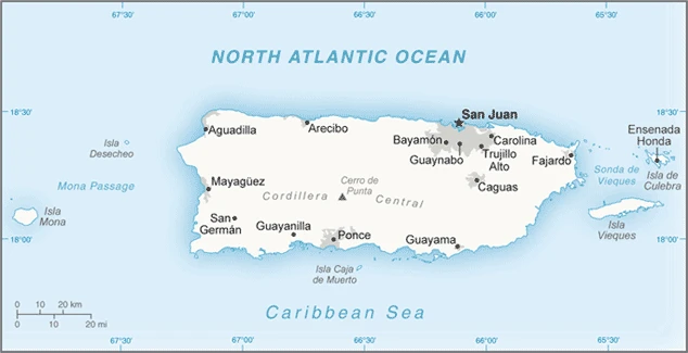
Puerto Rico is an island territory of the United States. It is a common misconception that it is in Central America, but it is part of the Caribbean. The land mass lies between the Caribbean Sea and the North Atlantic Ocean, north of Cuba and south of the US Virgin Islands.
This state is located in the Caribbean, an island between the Caribbean Sea and the North Atlantic Ocean, east of the Dominican Republic, under the coordinates of 18 15 N, 66 30 W, covering an area of 9,104 sq km with a coastline of 501 km. Puerto Rico is Slightly less than three times the size of Rhode Island.
Mostly mountains with a coastal plain in the north, steep mountains to the sea on the west coast, sandy beaches along most coastal areas, with Cerro de punta 1,338 m as the highest point of Puerto Rico, while the Caribbean Sea 0 m as the lowest point, causing a mean elevation at 261 m throughout the country. With a total of 9,104 sq km, Puerto Rico has 8,959 sq km of land and 145 sq km of water surface area.
An important location along the Mona Passage – a key shipping lane to the Panama Canal; San Juan is one of the biggest and best natural harbors in the Caribbean; many small rivers and high central mountains ensure land is well watered; the south coast is relatively dry; fertile coastal plain belt in the north.
The climate in Puerto Rico is as follows: Tropical marine, mild, with slight seasonal temperature variation.
When you visit Puerto Rico, the natural hazards shall be considered: Periodic droughts; hurricanes.
The following major health-threatening issues shall be considered when visiting Puerto Rico: none.
Current environmental issues affecting Puerto Ricans include soil erosion, occasional droughts causing water shortages, and industrial pollution.
Google Maps Puerto Rico
The capital and other divisions
Capital city: San Juan found under the coordinates 18 28 N, 66 07 W, applying the time zone UTC-4 (1 hour ahead of Washington, DC, during Standard Time), using the following daylight saving time: none.
San Juan is Puerto Rico’s capital and an important financial center for the island. San Juan has one of the biggest ports in the Caribbean region, and it also has a lot of natural resources. San Juan has become one of the top tourist destinations in the Western Hemisphere because of its natural beauty, beaches, and cultural diversity.
Puerto Rico became independent on none (territory of the US with commonwealth status), and its national holiday is US Independence Day, 4 July (1776); Puerto Rico Constitution Day, 25 July (1952).
Administrative divisions: none (territory of the US); there are no first-order administrative divisions as defined by the US Government, but there are 78 municipalities (municipios, singular – municipio) in the second order; Adjuntas, Aguada, Aguadilla, Aguas Buenas, Aibonito, Anasco, Arecibo, Arroyo, Barceloneta, Barranquitas, Bayamon, Cabo Rojo, Caguas, Camuy, Canovanas, Carolina, Catano, Cayey, Ceiba, Ciales, Cidra, Coamo, Comerio, Corozal, Culebra, Dorado, Fajardo, Florida, Guanica, Guayama, Guayanilla, Guaynabo, Gurabo, Hatillo, Hormigueros, Humacao, Isabela, Jayuya, Juana Diaz, Juncos, Lajas, Lares, Las Marias, Las Piedras, Loiza, Luquillo, Manati, Maricao, Maunabo, Mayaguez, Moca, Morovis, Naguabo, Naranjito, Orocovis, Patillas, Penuelas, Ponce, Quebradillas, Rincon, Rio Grande, Sabana Grande, Salinas, San German, San Juan, San Lorenzo, San Sebastian, Santa Isabel, Toa Alta, Toa Baja, Trujillo Alto, Utuado, Vega Alta, Vega Baja, Vieques, Villalba, Yabucoa, Yauco.
People and society
The population in Puerto Rico is 3,142,779 (July 2021 estimate), with an average of -1.46% (2021 estimate) change. That means Puerto Rico is the No. 135 in the world’s populated rank list. With an average of 43.6 years median age (41.6 years for males and 41.6 years for women), Puerto Rico ranks No. 25 on the globe’s median age list.
The people living in this country are Puerto Rican(s) (US citizens) (noun) or Puerto Rican (adjective) and belong mainly to the following ethnic groups: White 75.8%, Black/African American 12.4%, other 8.5% (includes American Indian, Alaskan Native, Native Hawaiian, other Pacific Islander, and others), mixed 3.3% (2010 estimate). Note: 99% of the population is Latino.
They speak Spanish and English languages and practice the following religions: Roman Catholic 85%, Protestant, and other 15%.
We can conclude the following about the population in Puerto Rico: Population clusters tend to be found along the coast, and the largest of these is found in and around San Juan. An exception to this is a sizeable population located in the interior of the island immediately south of the capital around Caguas. Most of the interior, particularly in the western half of the island, is dominated by the central cordillera mountains, with low population density. In Puerto Rico, we are talking about 93.6% (2021) of the total population living in cities, and most of them reside in the following municipalities: 2.445 million, San Juan (capital city) (2021).
Industry
Puerto Rico had one of the most dynamic economies in the Caribbean region until 2006; however, growth has been negative for the last 11 years. The downturn coincided with the phaseout of tax preferences that had led US firms to invest heavily in the Commonwealth since the 1950s and a steep rise in the price of oil, which generates most of the island’s electricity., Diminished job opportunities prompted a sharp rise in outmigration, as many Puerto Ricans sought jobs on the US mainland. Unemployment reached 16% in 2011 but declined to 11.5% in December 2017. US minimum wage laws apply in Puerto Rico, hampering job expansion. Per capita income is about two-thirds that of the US mainland. The industrial sector greatly exceeds agriculture as the locus of economic activity and income. Tourism has traditionally been an essential source of income, with estimated arrivals of more than 3.6 million tourists in 2008. Puerto Ricos merchandise trade surplus is solid, with exports nearly 50% greater than imports and its current account surplus about 10% of GDP.
Closing the budget deficit while restoring economic growth and employment remains the central concern of the government. The gap between revenues and expenditures amounted to 0.6% of GDP in 2016. However, analysts believe that not all expenditures have been accounted for in the budget and that a better accounting of costs would yield an overall deficit of roughly 5% of GDP. Public debt remained steady at 92.5% of GDP in 2017, about $17,000 per person, or nearly three times the per capita debt of the State of Connecticut, the highest in the US. State-run schools and public corporations issued much of that debt, including water and electric utilities.
In June 2015, Governor Alejandro GARCIA Padilla announced that the island could not pay back at least $73 billion in debt and that it would seek a deal with its creditors. Hurricane Maria hit Puerto Rico square in September 2017, causing electrical power outages to 90% of the territory, extensive loss of housing and infrastructure, and contamination of potable water. Despite massive efforts, more than 40% of the territory remained without electricity as of yearend 2017. As a result of the destruction, many Puerto Ricans have emigrated to the US mainland.
Puerto Rico is rich in the following natural resources: Some copper and nickel and the potential for onshore and offshore oil.
The main industrial sectors are pharmaceuticals, electronics, apparel, food products, and tourism.
The country’s export sectors are particularly strong in packaged medicines, medical cultures/vaccines, hormones, orthopedic and medical appliances, and sulfur compounds (2019), partnering with these nations: Italy 15%, Netherlands 15%, Belgium 9%, Japan 8%, Germany 8%, Austria 8%, Spain 7%, China 5% (2019). The export trade resulted in $73.17 billion. Note: Data are in current year dollars (2017 estimate). In a global rank of the export, values resulted in Puerto Rico’s position of 48.
Land use in Puerto Rico: 63.2% (2018 estimate) forest, 14.8% (2018 estimate) other.
The arable land area is 6.6% (2018 estimate), and the agricultural land is 22% (2018 estimate). Land use for permanent crops is 5.6% (2018 estimate), and permanent pasture is 9.8% (2018 estimate). The sum of the area of the irrigated land is 220 sq km (2012).
The main agro-industrial products of Puerto Rico are milk, plantains, bananas, poultry, tomatoes, mangoes/guavas, eggs, oranges, gourds, and papayas.
The country typically needs to import: nitrogen compounds, sulfur compounds, refined petroleum, medical cultures/vaccines, and cars (2019), partnering with the following nations: Ireland 38%, Singapore 9%, Switzerland 8%, South Korea 5% (2019) in a sum value of $49.01 billion (2017 estimate) $48.86 billion (2016 estimate). This sum value on the global ranking list of imports resulted in Puerto Rico 61.
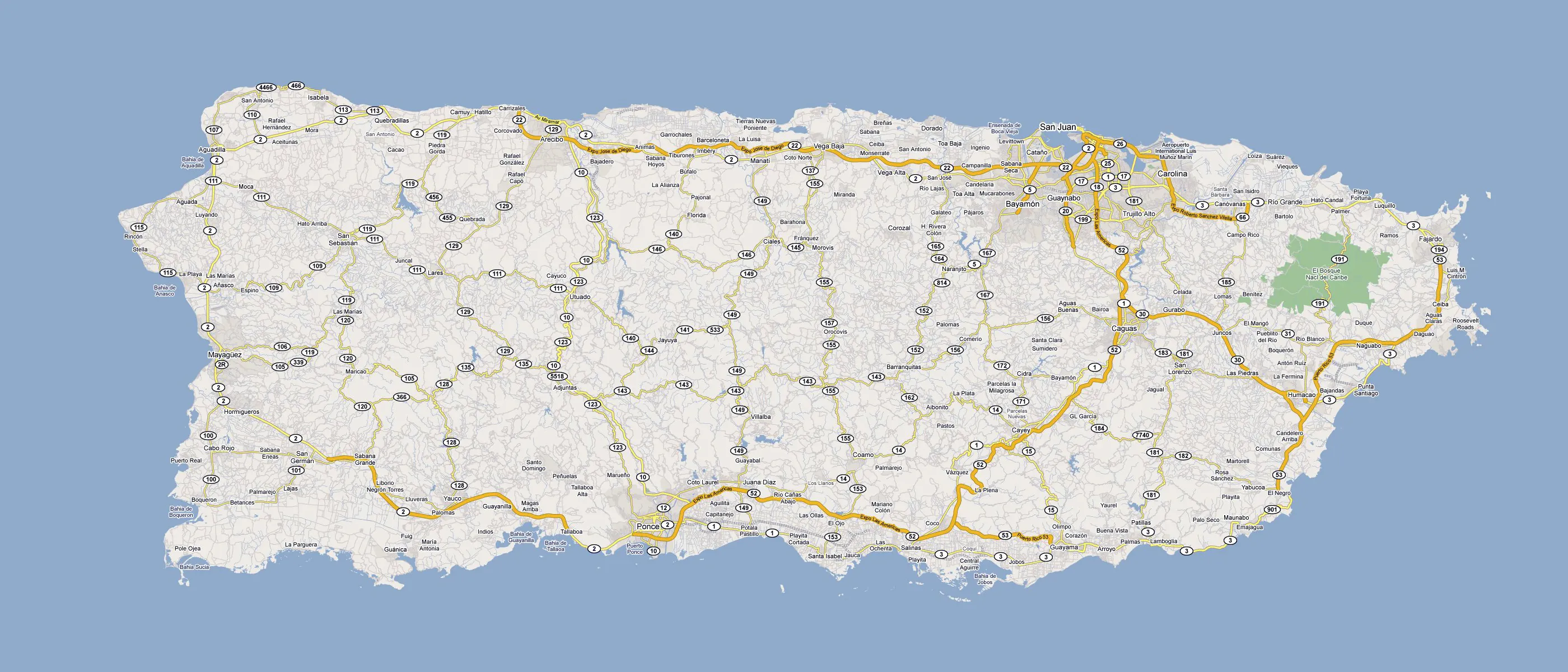
Puerto Rico Driving Directions
In this post, you learned about Puerto Rico, the Caribbean island between the Caribbean Sea and the North Atlantic Ocean, east of the Dominican Republic. We published some basic information about its capital San Juan, and the Puerto Rican nation.
Are you interested in visiting Puerto Rico and looking for driving directions? Click here to plan your route, or see a printable road map of Puerto Rico below for an overview of the route network.
Printable map of Puerto Rico
Did you know about Puerto Rico?
Did you know that Puerto Rico is an archipelago located in the Caribbean Sea, east of the Dominican Republic and west of the Virgin Islands? Despite being a territory of the United States, Puerto Rico has its unique culture, history, and identity. The island is known for its beautiful beaches, lush rainforests, and vibrant cities.
San Juan, the capital city of Puerto Rico, is known for its rich history and stunning architecture, including the 16th-century El Morro fortress and the Paseo de la Princesa, a charming promenade along the city’s historic district. The island is also known for its delicious cuisine, blending Spanish, African, and Taíno indigenous influences.
In recent years, Puerto Rico has faced numerous challenges, including natural disasters such as Hurricane Maria in 2017 and ongoing economic and political struggles. Despite these difficulties, the people of Puerto Rico remain proud of their heritage and continue working towards a brighter future for their island and community.
After virtually visiting Puerto Rico, you may also be interested in the neighboring countries: none.
If you liked our Google map and Puerto Rico information page,
please share it with others or save the link https://www.drivingdirections.net in your bookmarks.